


This article was automatically translated from the original Turkish version.
+2 More
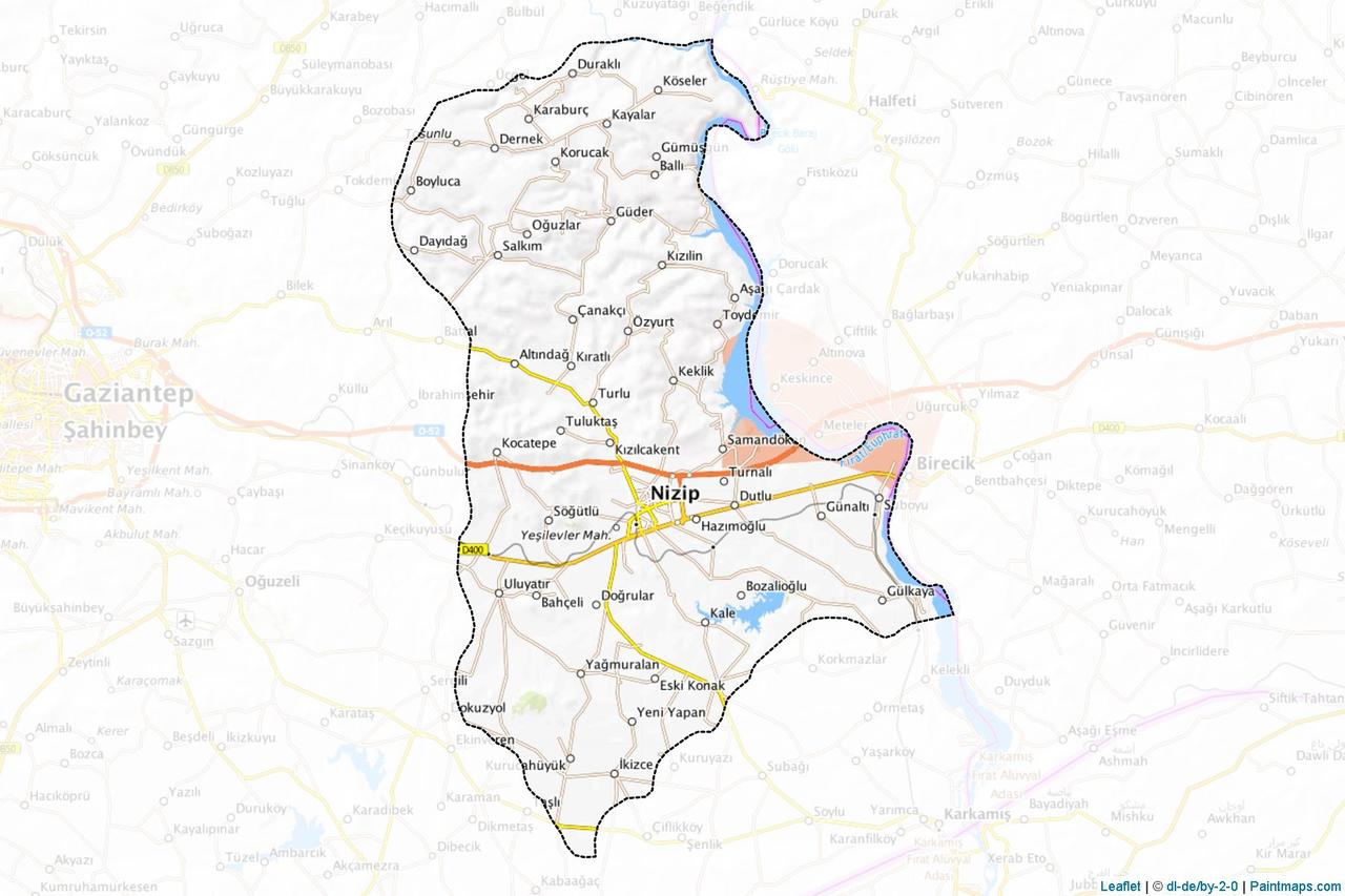
Nizip (District)
Region | Southeastern Anatolia | ||||||||
|---|---|---|---|---|---|---|---|---|---|
Neighbors | To the east Şanlıurfa (Birecik), to the south Karkamış, to the north Yavuzeli, to the west Gaziantep and Oğuzeli | ||||||||
Population | 151.246 (2024) | ||||||||
Coordinates | 36°38′ north latitude 36°28′ east longitude | ||||||||
Elevation | 400-500 metres (above sea level) | ||||||||
Area | 761.950 decares | ||||||||
District Governor | Osman Uğurlu | ||||||||
Mayor | Ali Doğan | ||||||||
Nizip is a district of Gaziantep province in the Southeastern Anatolia Region of Türkiye. Nizip, situated in the Euphrates River basin and noted for its historical and cultural richness as well as its geographical location, has been a settlement center for many civilizations throughout history. One of the district’s most important features is its hosting of archaeological sites such as the Belkıs/Zeugma Ancient City.
Nizip’s history extends back to the earliest periods of human history. The region’s cultural and historical periods can be categorized as Chalcolithic, Paleolithic, Iron, Hittite (Eti), Mitanni, Assyrian, Iranian, Hellenistic, Roman, Byzantine, Arab-Islamic and Turk-Islamic periods; remains from these eras are found in the district. Nizip has been inhabited since the Paleolithic Age (Stone Age), with traces of this era preserved in caves and mounds along the Belkıs Creek. During the Chalcolithic period, the region continued to serve as a settlement center, represented by sites such as Cabahöyük in Sakçagözü and Turlu “Şehzade” mound on the Nizip road.
During the Hittite period (18th century BCE), Nizip was incorporated into the Hittite state by King Mursili I. By the 13th century BCE, under Suppiluliuma, it became part of the Hittite Empire, and by the 12th century BCE, during the Late Hittite period, it became the regional center. After the Hittites, the region came under the control of the Assyrians, Medes, Alexander the Great, Romans and Byzantines. Nizip held religious significance during the Hittite period and gained strategic military importance during the Byzantine era. The Belkıs Ruins (Zeugma, later Seleucia ad Euphrates), located 8 km northeast of Nizip, are a significant settlement from the Byzantine period. Additionally, in the district center there is a Byzantine-era church building, and Byzantine remains are found in the villages of Orul (Sekili), Mızar (Uluyatır) and Çardak.
In 639 CE, Nizip was incorporated into the Arab state and after the Four Caliphs period passed under Umayyad administration. However, due to uprisings and civil wars within the Islamic state, it was recaptured by the Byzantines. The Abbasids regained control of the region in 780, and between 925 and 1013 it came under the control of the Hamdanids. During the Abbasid period, Nizip experienced significant development, and at one point Gaziantep was a settlement subordinate to Nizip. Starting from the 1st century CE, Turkic tribes began settling in the region, followed by rule from the Egyptian Mamluks and the Dulkadirids. The presence of Turks in the region dates to the mid-11th century. In 1098, the County of Edessa controlled the area, followed by the Seljuks in 1150, a period of Fatimid rule, Christian forces during the later Crusades, and finally the Ayyubids in 1187. During the Mamluk period (mid-12th century), Nizip entered a phase of prosperity, although this period was interrupted by invasions and occupations. From 1515 until 1516, the region was governed by the Dulkadirids and then the Egyptians before being incorporated into the Ottoman Empire in 1516.
During the Ottoman period, Nizip was the site of the Battle of Nizip on 29 June 1839, fought between the Ottoman army and Mehmet Ali Pasha, the Egyptian governor. This battle ended in an Ottoman defeat and affected the international political balance of the time. Nizip gained municipality status in 1904, at which time it was subordinate to the district of Birecik. During the War of Independence, it became one of the key centers of resistance against French occupation, where the first bullets were fired under the leadership of “Çete Habeş Böler”. In 1924, Nizip was attached to Gaziantep province and attained district status on 26 April 1926.
Nizip is the largest peripheral district of Gaziantep, bordered by Şanlıurfa (Birecik) to the east, Karkamış to the south, Yavuzeli to the north, and Gaziantep and Oğuzeli to the west. Located between 36°28′ east longitude and 36°38′ north latitude, the district lies at an elevation of 400 to 500 meters above sea level. Its total area is 761,950 decares. Situated in the Euphrates River basin, Nizip features a plateau extending eastward and plains to the south. The terrain is generally flat and not highly rugged.
Nizip lies in a transitional zone between Mediterranean and continental climates. Annual precipitation averages around 440 mm, occurring mostly in winter and spring. The summer season is completely dry, making it one of the driest areas in Türkiye. The average temperature is 16°C; the highest recorded temperature is 43°C and the lowest is -15°C. The dominant wind direction is from the south and west; hot and dry winds from the south during summer intensify aridity. The natural vegetation is steppe, but cultivated crops such as olive, pistachio and grape are widely grown.
Nizip’s social structure has been shaped by the influence of various cultures throughout history. The district possesses a rich heritage spanning from the Hittites to the Byzantines and from the Arabs to the Turk-Islamic period, reflecting this diversity in its social fabric. During the Ottoman period, Nizip was an important settlement center and is recognized as a region with strong national consciousness due to its resistance during the War of Independence. Today, the district maintains a community structure that preserves traditional values.
Nizip’s economy is based on agriculture and trade. Thanks to water resources provided by the Euphrates River, products such as olive, pistachio and grape are produced intensively. Its location along the E-90 highway also makes it a commercial link point. The tourism potential of the Belkıs/Zeugma Ancient City is also economically significant. The prosperity Nizip experienced during the Abbasid period, when Gaziantep was subordinate to it, demonstrates the region’s historical economic strength.
Nizip is an important tourism center due to its rich historical and natural attractions. The Belkıs/Zeugma Ancient City, located 10 km north of the district on the banks of the Euphrates River, was founded in 300 BCE by Seleucus Nicator. During the Roman period, this city, known as Zeugma, had a population of 80,000 and was among the largest cities of its time. It is renowned for its mosaics, villas and strategic location. Rumkale, another significant tourist site, is situated on steep cliffs where the Euphrates River meets the Merzimen Creek. It features structures dating from the Late Roman and Medieval periods. Fevkani Church is a structure from the Byzantine period that was converted into a mosque in the 1800s. Additionally, the Karpuzatan Picnic Area along the Nizip Creek is an attractive destination for nature lovers. Mounds (Nizip, Belkıs, Horum) preserve traces of prehistoric settlements.
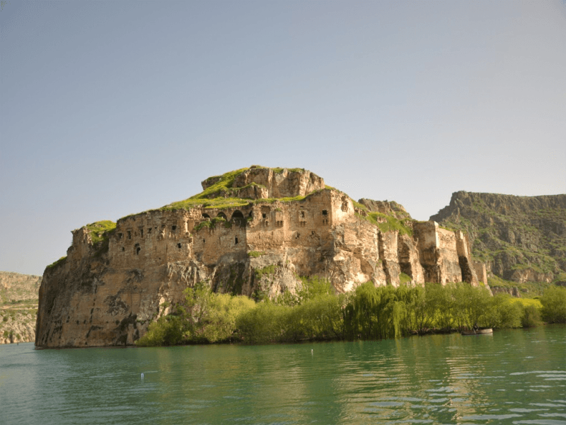
Nizip Rumkale (Nizip Municipality)
In the 1927 census, Nizip’s population was recorded as 7,041. However, due to limited employment opportunities at the time, significant migration occurred to Gaziantep. Today, as Gaziantep’s largest peripheral district, Nizip has increased its population and modernized. Throughout history, Nizip has been settled by communities from various civilizations, resulting in demographic diversity.
Gaziantep Büyükşehir Municipality. "Nizip." Gaziantep Metropolitan Municipality Website. Accessed April 9, 2025.https://www.gaziantep.bel.tr/tr/ilceler/nizip
Nizip Belediyesi. "Coğrafya." Nizip Belediyesi Web Sitesi. Accessed April 9, 2025.https://www.nizip.bel.tr/nizip/cografya
Nizip Belediyesi. "Ulaşım." Nizip Belediyesi Web Sitesi. Accessed April 9, 2025.https://www.nizip.bel.tr/nizip/ulasim
Nizip Belediyesi. “Rumkale.” Nizip Belediyesi Web Sitesi. Accessed April 9, 2025.https://www.nizip.bel.tr/nizip/rumkale
Nizip Belediyesi. “Tarihçe.” Nizip Belediyesi Web Sitesi. Accessed April 9, 2025.https://www.nizip.bel.tr/nizip/tarihce
Nizip Belediyesi. “Turizm.” Nizip Belediyesi Web Sitesi. Accessed April 9, 2025.https://www.nizip.bel.tr/nizip/turizm
Nizip Belediyesi. “Zeugma.” Nizip Belediyesi Web Sitesi. Accessed April 9, 2025.https://www.nizip.bel.tr/nizip/zeugma
T.C. Nizip Kaymakamlığı. "Kültürel Değerlerimiz." T.C. Nizip Kaymakamlığı Web Sitesi. Accessed April 9, 2025.http://www.nizip.gov.tr/kulturel-degerlerimiz
T.C.Nizip Kaymakamlığı Governorship. "Tarihçe." T.C. Nizip District Governorship Website. Accessed April 9, 2025.http://nizip.gov.tr/tarihce

Nizip (District)
Region | Southeastern Anatolia | ||||||||
|---|---|---|---|---|---|---|---|---|---|
Neighbors | To the east Şanlıurfa (Birecik), to the south Karkamış, to the north Yavuzeli, to the west Gaziantep and Oğuzeli | ||||||||
Population | 151.246 (2024) | ||||||||
Coordinates | 36°38′ north latitude 36°28′ east longitude | ||||||||
Elevation | 400-500 metres (above sea level) | ||||||||
Area | 761.950 decares | ||||||||
District Governor | Osman Uğurlu | ||||||||
Mayor | Ali Doğan | ||||||||
History
Geographical Structure
Climate and Vegetation
Social Structure
Economic Structure
Tourism Potential
Demographic Structure