


This article was automatically translated from the original Turkish version.
+1 More
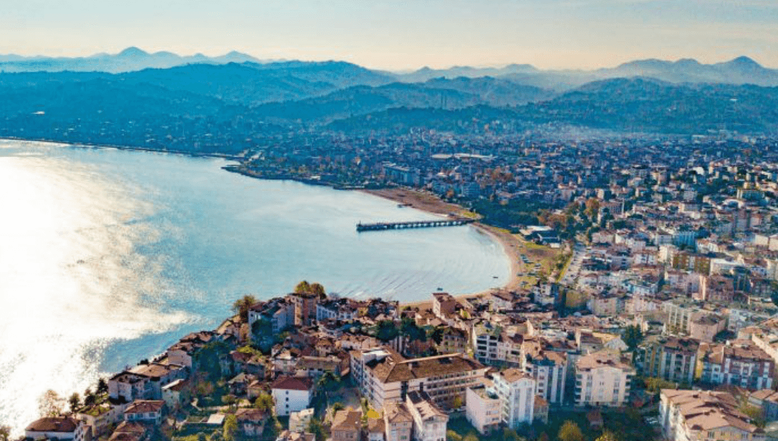
Ünye
Province | Ordu | ||||||||
|---|---|---|---|---|---|---|---|---|---|
Geographic Region | Black Sea | ||||||||
Elevation | 10 | ||||||||
Area | 440 km² | ||||||||
Population | 132.915 (2024) | ||||||||
Mayor | Hüseyin TAVLI | ||||||||
District Governor | Ayhan IŞIK | ||||||||
Ünye is a district located in Türkiye’s Black Sea Region, known primarily for its hazelnut cultivation. In addition to its agricultural production, the district plays a regional role through its industrial and commercial activities. Ünye’s historical and geographical characteristics are significant factors influencing its position within the Black Sea Region. Hazelnuts are a major agricultural product in the district, and industrial and commercial activities contribute to diversifying the local economy.
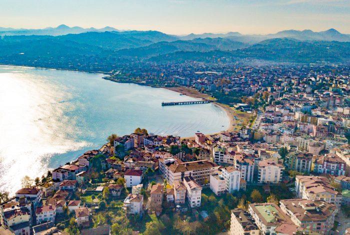
Ünye (Source: Ünye Municipality)
Ünye is a district situated along the Black Sea coast, and research indicates that its surroundings are among the earliest human settlements in Anatolia. Excavations conducted by Prof. Dr. İ. Kılıç Kökten in the Cevizdere Valley have uncovered evidence of human habitation dating back to the 15th millennium BCE. Artifacts from the Paleolithic and Neolithic periods—including stone tools, weapons, pottery, and human and domestic animal skeletons—were discovered at these sites. A flint hand axe from the Lower Paleolithic period is the oldest such find ever recorded on the Black Sea coast.
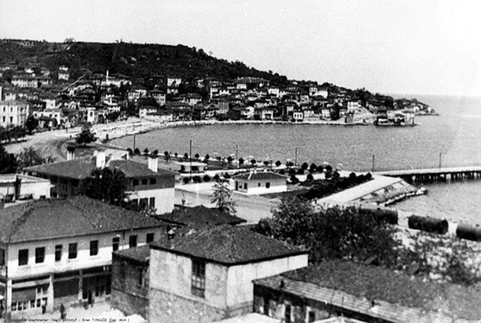
Historical Ünye (Source: Ünye Municipality)
The earliest group mentioned in written records in and around Ünye are the Kashkans (circa 2000 BCE). Subsequently, the region came under the rule of the Hittites, Scythians (Sakas), Cimmerians, Chalybes, Greeks (during the colonization period of the 8th century BCE), Persians, Pontic rulers, and Romans. Around 750 BCE, Milesian colonists established a trading colony named Oinoie. The name derives from the Luvian word “Oinos,” meaning “vineyard, grape, wine,” reflecting the region’s significance in antiquity. Following the division of the Roman Empire in 395 CE, Ünye became part of the Eastern Roman (Byzantine) Empire.
During the Turkification of Anatolia, Ünye and its surroundings became a battleground between the Danishmendids and the Anatolian Seljuks. In 1080, the Black Sea coast was incorporated into the Great Seljuk Empire. Turkish dominance in the region began with conquests initiated by Melik Ahmed Gazi of the Danishmendids. During the reign of Melik Yağıbasan (1150–1164), Bafra, Samsun, and Ünye were recaptured, but due to alliances with the Byzantines, these territories were periodically lost and regained. By 1178, all Danishmend territories were fully integrated into the Anatolian Seljuk State.
With the decline of the Anatolian Seljuks, the region entered the period of the Canik Beyliks. Ünye came under the control of the Hacı Emir Beylik and was definitively conquered by Hacı Emir Bey in 1346. The Hacı Emir Beylik became subordinate to the Eretna State and the state of Kadı Burhaneddin, and later acknowledged Ottoman authority as the Ottomans advanced into the region. In 1398, following Yıldırım Bayezid’s campaign in Canik, Süleyman Bey of the Hacıemiroğulları submitted to the Ottomans along with other Canik beyliks. In 1461, during Fatih Sultan Mehmed’s campaign against Trabzon, the Hacı Emir Beylik was abolished and Ünye was directly incorporated into the Ottoman State.
Under Ottoman rule, Ünye enjoyed a prolonged period of stability as an important port and commercial center. In the 16th century, the Canik Sanjak was subordinate to the Sivas Eyalet. The Ünye shipyard played a vital role in constructing warships for the state. During the 18th century, as central authority weakened within the Ottoman Empire, local notables such as the Caniklioğulları (the family of Hacı Ali Pasha) gained power in the Canik region. However, by the early 19th century, the influence of the Caniklioğulları had ended.
Administrative reorganizations occurred in the 19th century: Ünye briefly attained the status of a sanjak before being reverted to a kaza. Following Russia’s occupation of the Caucasus, Circassian and Georgian migrations entered the region.
During World War I, Ünye was bombed by Russian ships. During the War of Independence, Hasan Fehmi Efendi of Ünye served as a deputy for Canik in the Grand National Assembly of Türkiye. Ünye residents participated in resistance organizations against Pontic Greek activities. After the proclamation of the Republic, Ünye became a district subordinate to Ordu Province. In 1954 and 1990, several sub-districts were separated to form the new districts of Akkuş, Çaybaşı, and İkizce. Although Ünye’s population declined in the early years of the Republic, it later resumed growth and increased further after Ordu attained metropolitan status.
Ünye is located between 41° 09′ North Latitude and 37° 88′ East Longitude. The district center borders Fatsa and Terme districts along the Black Sea coast and shares boundaries with Akkuş, İkizce, and Çaybaşı districts inland. It is approximately 61 km from Ordu city center and covers a total area of 487 km². Following Ordu’s acquisition of metropolitan status in 2013, Ünye had 85 neighborhoods as of 2017.
Administratively, the southern, eastern, and western boundaries of Ünye district center are defined by rivers, while the northern boundary is the Black Sea and the southern boundary is the North Anatolian Mountains. The district center is built on a wide crescent-shaped bay. Its nearly flat topography distinguishes it from the typical rugged geography of eastern Black Sea. The Tabakhane Creek, which flows through the district, divides the settlement approximately into a one-third eastern and two-thirds western section. The Akçay River to the west forms the natural boundary between Ünye and Terme. Within the district boundaries, various elevated areas include Çet Hill (402 m), Kızılkaya Hill (392 m), and Erkiz Hill (391 m).
Ünye lies within the influence of the Black Sea climate. Due to its maritime location and low elevation, humidity levels are high. The annual average temperature is 14.4 °C, and the average annual rainfall is approximately 1,183 mm. Important rivers in the region include the Lahna, Tabakhane, Curi, and Ceviz creeks.
Soil types are generally gray-brown podzolic, brown forest, and alluvial soils. The area on which the district center is built consists of alluvial material deposited by rivers.
The vegetation reflects the typical characteristics of the Black Sea Region. Mixed forest types predominate, with widespread stands of fir, cedar, coastal pine, and forest roses. The extensive areas of agricultural and forest land have limited urban expansion. However, human activities have led to deforestation and land conversion for settlement purposes. More than 50% of the district’s land is used for agriculture.
According to 2024 data, Ünye’s total population is 132,915, with a population density of 230.75 persons per km². Gender distribution is nearly balanced, with approximately 50% of the population being female and 50% male.
By age group, 32% of the population is young (0–24 years), 48% is of working age (25–64 years), and 20% is elderly (65 years and over). These figures indicate a significant proportion of the population in the working-age bracket.
In terms of education levels, 14% of the population has completed university or higher education. The largest segment, 69%, has received primary, secondary, or high school education. The remaining 17% fall into other educational categories. These figures show that secondary education is widespread in the district, while higher education rates remain relatively low.
Due to its location on the Black Sea coastal highway, Ünye holds a strategic position in transportation, and increasing emphasis has been placed on improving the quality and infrastructure of its transport systems.
Ünye is integrated into a well-developed road network. The D010/E70 highway passes through the district center, providing direct connections to major cities such as Samsun to the west and Ordu and Giresun to the east. Regular bus services operate between Ünye and Ordu city center, approximately 61 km away. Frequent bus services also connect Ünye to Samsun. Intra-district transportation is provided by municipal and private minibuses, linking the district center with surrounding neighborhoods and rural settlements. Taxi stands are located in the district center and designated locations.
Historically, Ünye served as an important commercial port. Today, Ünye Port continues to function primarily for commercial activities and as a fishing harbor. Although there are no regular passenger ferry services, infrastructure exists to accommodate private vessels such as boats and yachts.
The nearest civilian airport to Ünye is the Ordu-Giresun Airport, located approximately 70 km away. Access to Ünye district center is provided via private car, taxi, or airport shuttle services. Ordu-Giresun Airport offers regular scheduled flights to major cities including Istanbul and Ankara.
Transportation dynamics in Ünye district center are based on pedestrian movement and public transit. The relatively low population density allows for easy walking access to many locations. The public transit system relies primarily on municipal buses and private minibuses, which operate routes connecting the district center with surrounding neighborhoods. Taxi services are available 24 hours a day as an alternative for urban mobility.
Agriculture plays a significant role in Ünye’s economy. Hazelnut production is a primary source of income for the district and region. Ordu Province is one of Türkiye’s major hazelnut-producing regions, and Ünye contributes significantly to this output. Hazelnut orchards occupy a substantial portion of the district’s agricultural land. High labor costs and challenges faced by producers in price determination are notable concerns.
The industrial sector in Ünye is developing. The district hosts various industries, including food processing, bentonite refining, and ready-made garment manufacturing. There are registered industrial enterprises. Industrial zones are located outside residential areas, in regions with adequate transportation access.
Ünye functions as a commercial center serving surrounding regions. Commercial areas are concentrated in the city center. The main destinations for sales are Istanbul, Ordu, Samsun, Hatay, and Sakarya. Major sources of imports are Istanbul, Ordu, Trabzon, Giresun, and Hatay.
The proportion of Ünye’s population aged 15–64 (working age) is 73.5% of the total population. The district has a population of college graduates. According to the Socioeconomic Development Index (SEDI), Ünye ranks in the middle among districts in Türkiye and third within Ordu Province, after Altınordu and Fatsa. Investments in the district benefit from incentives designated for Region 5 under Türkiye’s investment incentive system.
Ünye, located in the Black Sea Region, possesses diverse tourism potential.
The district features recreational areas such as Çamlık, a wooded slope overlooking the sea that includes the Çamlık Motel as an accommodation facility. Çakırtepe is a hill offering panoramic views of the city and is known for its rest areas. Beaches such as Uzunkum, İncekum, İnciraltı, and Çınarsuyu provide opportunities for seaside tourism. Natural sites within the district include Asarkaya National Park and Yazkonağı Caves, which hold potential for cave tourism.
Ünye also attracts interest through its historical and cultural heritage. Ünye Castle is a historical structure. Restored Ünye houses reflect traditional Black Sea architecture. The Yunus Emre Türbesi is also located in the district. Historic streets such as the Anıt Çınar trees in the city center and Kadılar Yokuşu are notable. Additionally, historical structures such as churches and hammams exist within the district.
Ünye offers accommodation facilities including star-rated hotels and modern hotels/pensions. The Çınarsuyu Holiday Complex is an example of tourism infrastructure.
The Ünye Living Cultural Heritage Museum exhibits characteristics of 19th-century Classical Ottoman architecture. It was expropriated in 2009 and restored by 2013 with technical support from Prof. Dr. Zeynep Ahunbay. In 2013, it received an award from the Union of Historic Cities in the Competition for Encouraging the Protection and Implementation of Historical and Cultural Heritage. The museum house was converted into a Living Cultural Heritage Museum to preserve intangible cultural heritage and enhance tourism potential. It is the fourth such museum in Türkiye, the first in the Black Sea Region, and the only museum in Türkiye authorized to use the UNESCO logo.
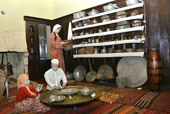
Living Cultural Heritage Museum (Source: Ünye Municipality)
Kadılar Yokuşu was historically the place where many judges were trained in the Ottoman period. The position of judge was passed down from father to son in Ünye. Judges of the era and their descendants built mansions along this slope, which became known as the Judges’ Quarter. Many of these mansions still stand today. Kadılar Yokuşu is notable for its original stone-paved path, stone-carved entrance gates, and historic Ünye houses.
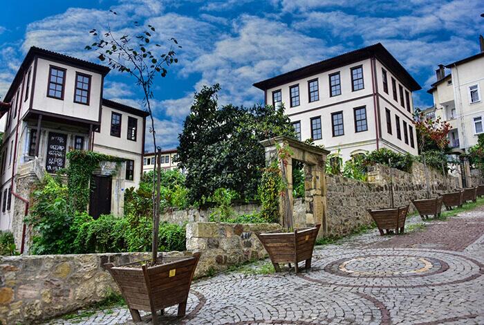
Kadılar Yokuşu (Source: Ünye Municipality)
Çifte Hamam was constructed in the early 800s by Armenian stone masons using quarried stone from Taşhane Cape. Closed at the end of the 1930s and remaining unused since, the bathhouse has deteriorated over time due to lack of maintenance. It has been placed under protection by Ünye Municipality.
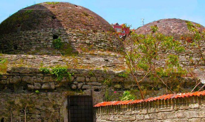
Çifte Hamam (Source: Ünye Municipality)
Located 9 km from the city along the Ünye-Fatsa highway, Asarkaya National Park and Recreation Area sits at an elevation of 360 meters. The park offers opportunities for picnicking and outdoor sports in harmony with nature. Accessible year-round, the area provides visitors with the chance to enjoy time immersed in the natural environment.
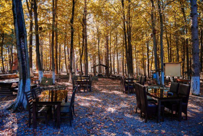
Asarkaya Urban Forest (Source: Ünye Municipality)
Located 2 km northwest of the district center, where the sea meets the forest, Çamlık is a favored recreational and picnic area for residents of Ünye and surrounding regions. Named after the pine trees planted in the 1940s, Çamlık also contains 19th-century Greek cemeteries. It offers visitors sea views, walking and jogging paths, and shaded seating areas beneath the pines.
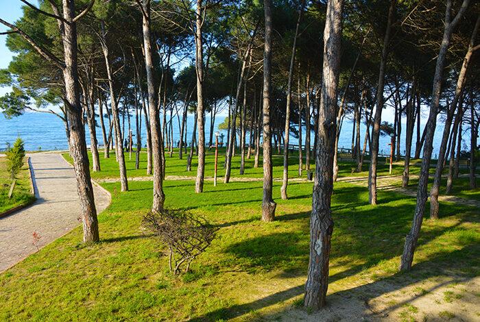
Çamlık (Source: Ünye Municipality)
The Turk-Japanese Friendship and Ertuğrul Frigate Martyrs Monument was erected in 2014 in memory of Turkish sailors who perished when the Ertuğrul Frigate sank after being caught in a typhoon near Kushimoto, Japan, on 16 September 1890, shortly after departing Yokohama Harbor.
In September 1891, near the site where survivors reached shore and received initial medical care, a memorial monument was erected. The original monument bore inscriptions in both Japanese and Turkish, detailing Osman Pasha’s mission and the tragedy.
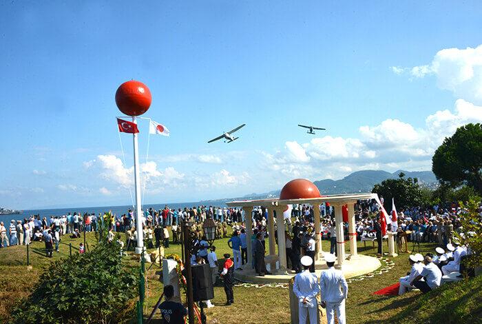
Turk-Japanese Friendship and Ertuğrul Frigate Martyrs Monument (Source: Ünye Municipality)
Ünye Castle is a historical structure located approximately 5–7 km from the city center along the Ünye-Niksar highway, situated atop a hill at an elevation of about 300 meters.
The castle’s earliest construction dates back to around 250 BCE and was commissioned by King Mithridates II of Pontus. Throughout history, the castle was used by various peoples and underwent multiple modifications. Major powers that utilized the castle include the Romans, Pontic rulers, and the Ottoman State, which gave it its final form.
Rock-cut tombs are found within the castle. These tombs were carved into tall, upright rock formations. Near the summit, two passageways and a cistern are located, sloping at a 45-degree angle toward the northwest. One of the passageways is believed to have 420 steps leading down to the castle’s base.
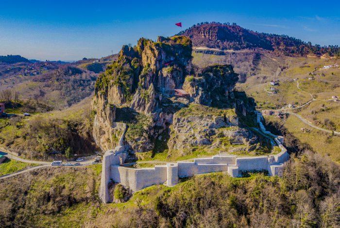
Ünye Castle (Source: Ünye Municipality)
The historic plane tree in Ünye Square welcomes visitors. Its planting story is as follows: In 1461, while returning from his campaign against Trabzon, Fatih Sultan Mehmet, accompanied by Akşemseddin, noticed the absence of trees in Ünye Square. He then declared, “Let us plant a tree here so that when we return, we will have shade,” and personally planted a plane sapling.
This historic plane tree in Cumhuriyet Square is estimated to be approximately 556 years old. Its circumference is 9 meters, its diameter is 2.5 meters, and its height is 30 meters. However, in 1950, a lightning strike damaged and partially burned its trunk.
It is said that all roads in Ünye lead to this tree, and the surrounding area is known as the Square.
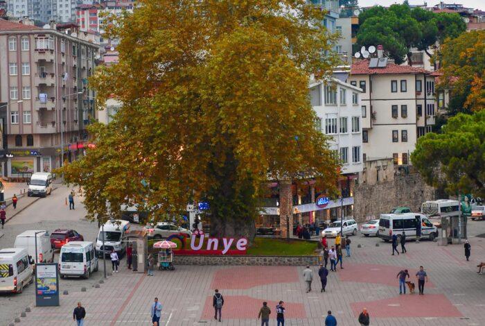
Historic Plane Tree (Source: Ünye Municipality)
With a 27-kilometer coastline, Ünye is among Türkiye’s pristine coastal areas. One of its most distinctive features is its beaches. Ünye’s beaches have recently attracted global attention due to their magnetic properties and claims of therapeutic benefits. The black sand, rich in minerals, is believed to stimulate the thymus gland and alleviate stress and sleep disorders, as well as conditions such as rheumatism and psoriasis.
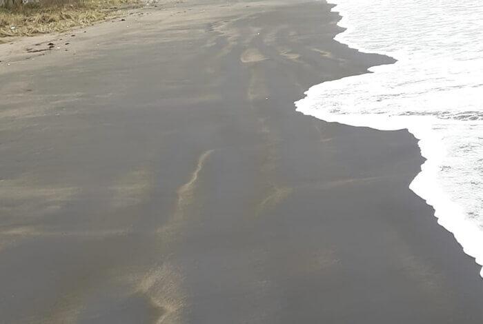
Magnetic Beaches (Source: Ünye Municipality)
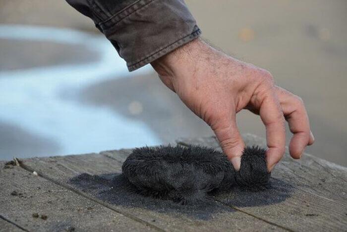
Magnetic Beaches (Source: Ünye Municipality)
The Ünye Pier was constructed to support the maritime trade activities of Ünye, once one of the most important ports of the Black Sea. During the Ottoman period, goods such as hazelnuts, timber, and minerals were transported by ship from this region. In the Republican era, it became primarily a facility serving local transportation and fishing activities.
In its modern form, the Ünye Pier is a mixed structure of wood and reinforced concrete. The entrance has been widened into a pedestrian walkway, making it easily accessible to the public. It is especially popular among photographers and walkers during sunset hours.
Today, the Ünye Pier is used mainly as a social and tourist area. During summer months, concerts, cultural events, and performances are held on the pier. It is also a significant attraction for amateur fishermen and those seeking to enjoy the seaside. Through renovations by Ünye Municipality, the pier has become a symbolic structure strengthening Ünye’s relationship with the sea.
Together with walking paths, cafés, and rest areas along the shore, the pier supports Ünye’s tourist identity. Combined with the region’s natural beauty, this structure enhances the significance of Ünye’s position along the Black Sea coast.
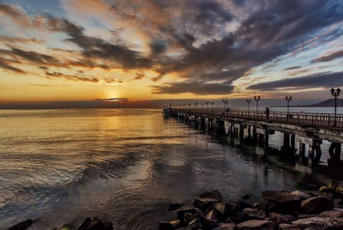
Ünye Pier (Source: Ünye Municipality)
"Asarkaya Kent Ormanı." Ünye Belediyesi. Accessed April 24, 2025.https://www.unye.bel.tr/sehir-rehberi/asarkaya-kent-ormani/
"Kadılar Yokuşu." Ünye Belediyesi. Accessed April 24, 2025.https://www.unye.bel.tr/sehir-rehberi/kadilar-yokusu/
"Manyetik Kumsallar." Ünye Belediyesi. Accessed April 24, 2025.https://www.unye.bel.tr/sehir-rehberi/manyetik-kumsallar/
"Tarihi Çınar." Ünye Belediyesi. Accessed April 24, 2025.https://www.unye.bel.tr/sehir-rehberi/tarihi-cinar/
"Turk-Japanese Friendship and the Martyrs of theErtuğrul Fırkateyni Monument." Ünye Belediyesi. Accessed April 24, 2025.https://www.unye.bel.tr/sehir-rehberi/turk-japon-dostlugu-ve-ertugrul-firkateyni-sehitleri-aniti/
"Turk-Japanese Friendship and theErtuğrul Fırkateyni." T.C. Dışişleri Bakanlığı. Accessed April 24, 2025.https://www.mfa.gov.tr/data/enformasyon/ertugrul-firkateyni.pdf
"Yaşayan Kültürel Miras Müzesi." Ünye Belediyesi. Accessed April 24, 2025.https://www.unye.bel.tr/sehir-rehberi/yasayan-kulturel-miras-muzesi/
"Çamlık." Ünye Belediyesi. Accessed April 24, 2025.https://www.unye.bel.tr/sehir-rehberi/camlik/
"Çifte Hamam." Ünye Belediyesi. Accessed April 24, 2025.https://www.unye.bel.tr/sehir-rehberi/cifte-hamam/
"Ünye Coğrafi Konumu." Ünye Kaymakamlığı. Accessed April 24, 2025.http://www.unye.gov.tr/unyenin-cografi-konumu
"Ünye Coğrafyası." Ünye Belediyesi. Accessed April 24, 2025.https://www.unye.bel.tr/sehir-rehberi/unye-cografyasi/
"Ünye Ekonomik Yapısı." Doğu Karadeniz Kalkınma Ajansı (DOKA). "Ünye İlçe Yatırım Ortamı Raporu", 2019.https://www.doka.org.tr/dosyalar/page_108/attachment/unye-ilce-yatirim-ortami-raporu.pdf
"Ünye Fotoğrafları." Ünye Belediyesi. Accessed April 24, 2025.https://www.unye.bel.tr/galeri/unye-resimleri-2021/
"Ünye Kalesi." Kültür Portalı. Accessed April 24, 2025.https://www.kulturportali.gov.tr/turkiye/ordu/gezilecekyer/unye-kalesi
"Ünye Kalesi." Ünye Belediyesi. Accessed April 24, 2025.https://www.unye.bel.tr/sehir-rehberi/unye-kalesi/
"Ünye Sosyo-Ekonomik Yapı." Ünye Ticaret ve Sanayi Odası. Accessed April 24, 2025.https://unyetso.org.tr/unye/sosyo-ekonomik-yapi
"Ünye Tarihi." Ordu Valiliği. Accessed April 24, 2025.http://www.ordu.gov.tr/unye
"Ünye Tarihi." Ünye Belediyesi. Accessed April 24, 2025.https://www.unye.bel.tr/sehir-rehberi/unye-tarihi/
"Ünye Tarihi." Ünye Kaymakamlığı. Accessed April 24, 2025.http://www.unye.gov.tr/unyenin-tarihi
"Ünye İskelesi." Ünye Belediyesi. Accessed April 24, 2025.https://www.unye.bel.tr/sehir-rehberi/unye-iskelesi/
Demographic Structure. *Endeksa*. Accessed April 24, 2025.https://www.endeksa.com/tr/analiz/turkiye/ordu/unye/demografi
Özdemir, Fatih. "Ünye Şehrinde Sanayi ve Ticaret Fonksiyonlarının Mekânsal Analizi." Academia.edu, 2021.https://www.academia.edu/78963585/%C3%9Cnye_%C5%9Eehrinde_Sanayi_ve_Ticaret_Fonksiyonlar%C4%B1n%C4%B1n_Mek%C3%A2nsal_Analizi
Ünye Kaymakamlığı. "Ünye Kalesi." Accessed April 24, 2025.http://www.unye.gov.tr/unye-kalesi.
“Ünye’nin Ekonomik Yapısı.” Accessed April 24, 2025.https://dergipark.org.tr/tr/download/article-file/934383.
Ünye
Province | Ordu | ||||||||
|---|---|---|---|---|---|---|---|---|---|
Geographic Region | Black Sea | ||||||||
Elevation | 10 | ||||||||
Area | 440 km² | ||||||||
Population | 132.915 (2024) | ||||||||
Mayor | Hüseyin TAVLI | ||||||||
District Governor | Ayhan IŞIK | ||||||||
History
Geography and Climate
Vegetation
Population and Demographic Structure
Transportation
Road Transport
Sea Transport
Air Transport
Urban Transport
Economy
Agriculture
Industry
Commerce
Other Economic Indicators
Tourism Potential
Living Cultural Heritage Museum
Kadılar Yokuşu (Judges’ Slope)
Çifte Hamam (Double Bathhouse)
Asarkaya Urban Forest
Çamlık
Turk-Japanese Friendship and Ertuğrul Frigate Martyrs Monument
Ünye Castle
Historic Plane Tree
Magnetic Beaches
Ünye Pier