


This article was automatically translated from the original Turkish version.
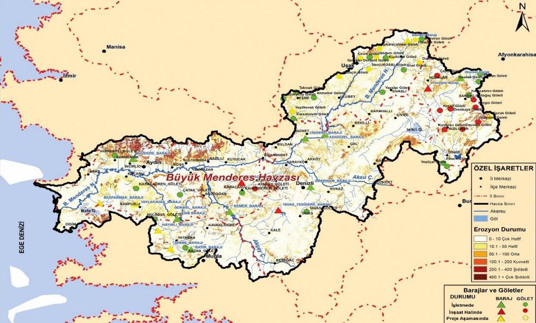
Great Menderes Basin
Surface Area | 25,987 km² | ||||||||
|---|---|---|---|---|---|---|---|---|---|
Distribution by Provinces | Denizli (%32.09) Aydın (%29.28) Muğla (%9.50) Uşak (%13.94) Afyonkarahisar (%12.61) | ||||||||
Main River | Büyük Menderes Nehri | ||||||||
River Length | Approximately 600 km | ||||||||
Major Tributaries | Akçay Çine Çayı Dandalas Çayı Banaz Çayı More than 50 small and large streams | ||||||||
Surface Water Status | Only 9% of the 134 surface water bodies are in good or very good condition; 72 have not been monitored at all. | ||||||||
Groundwater Status | Seven of the 38 groundwater bodies have been assessed as being in 'poor' condition. | ||||||||
Great Menderes Basin is a large hydrological and ecological region centered around the Great Menderes River, one of Türkiye’s major river systems, located in Western Anatolia. The river originates in the Dinar district of Afyonkarahisar and flows approximately 584 kilometers before emptying into the Aegean Sea. The basin covers an area of about 25,987 km², encompassing the provinces of Aydın, Denizli, Uşak, Muğla, and Afyonkarahisar.
Geographically situated in the southern part of the Aegean Region, the basin holds significant importance both for its natural environment and for its socio-economic activities due to its fertile agricultural lands, abundant surface and groundwater resources, biological diversity, and cultural heritage. Agricultural production, in particular, enhances the basin’s regional and national significance. However, factors such as urbanization, industrialization, unsustainable water use, and climate change threaten the basin’s sustainability.
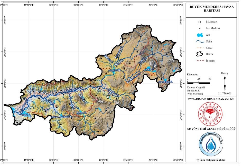
Büyük Menderes Havzası ( T.C. Tarım ve Orman Bakanlığı Su Yönetimi Genel Müdürlüğü)
Great Menderes Basin is located in Türkiye’s Western Anatolia Region and features a rich physical geography composed of numerous mountains, plains, and valleys. The most distinctive characteristic of the basin is the harmonious integration of high mountainous areas in the interior with low-lying valleys and plains traversed by the river. The Great Menderes River originates in these mountainous regions and flows through extensive plains and agricultural lands. Within the basin’s overall structure, fertile agricultural areas such as the Alaşehir Plain, Nazilli Plain, and Çine Plain play a prominent role.
The basin contains major mountain ranges including the Bozdağlar, Menteşe Mountains, and Aydın Mountains. These mountains define the northern and southern boundaries of the basin and directly influence the regional hydrological cycle and climatic conditions. The lowland areas in the center of the basin form the valleys of the Menderes River, which are the most intensively cultivated regions.
The Great Menderes Basin is defined by the Great Menderes River, from which it derives its name. The river originates in the Dinar district of Afyonkarahisar and flows through the boundaries of Aydın Province before emptying into the Aegean Sea. It serves as the region’s primary water source, supplying irrigation to surrounding agricultural lands. With a length of approximately 584 kilometers, the Great Menderes River has a vast drainage basin. Other important tributaries within the basin include the Small Menderes, Çine Creek, and Aksu Creek.
The Great Menderes River can reach high discharge levels that occasionally cause flooding, leading to significant agricultural losses, particularly in the plains. Therefore, management of water resources in the region is of great importance. Numerous dams and regulators have also been constructed along the river, serving various purposes such as irrigation and hydropower generation.
Groundwater resources in the region are also of considerable importance. Groundwater is vital for irrigation systems, especially in agriculture. However, in recent years, problems such as excessive water consumption and declining groundwater levels have raised concerns about the sustainability of water resources.
The Great Menderes Basin is one of Türkiye’s key agricultural regions, renowned for its fertile plains. The basin stands out as an area with extensive irrigation potential and abundant surface and groundwater resources. Agriculture forms the foundation of the basin’s economy, and many local settlements are directly dependent on agricultural activities.
The most prominent agricultural products in the basin include cotton, olives, fruit (particularly figs, pomegranates, and grapes), vegetables, and tobacco. Olive and fig production hold significant importance in districts such as Nazilli, Aydın, Çine, and Kuşadası. Olive cultivation is one of the most important agricultural products of the Aegean Region and a major contributor to the regional economy. Similarly, Grapes and Wine Production also represent key aspects of the basin’s agricultural richness.
Cotton production in the Great Menderes Basin is widespread, largely due to the availability of irrigation. Cotton is one of the key raw materials for the region’s industry, and the areas where it is grown also serve the textile sector. In this context, the basin is an important production area not only for agriculture but also for agro-industry.
Thanks to irrigation infrastructure, the basin also produces a variety of fruits and vegetables. Irrigation water is primarily drawn from the Great Menderes River and various groundwater sources. However, in recent years, issues such as depletion of water resources and excessive water consumption have threatened agricultural activities in the region.
Livestock farming is also an important economic activity in the Great Menderes Basin. The region is rich in sheep and goat rearing. Cattle and small ruminant production also hold significant importance. Alongside agriculture-based economic activities, fishing and beekeeping contribute to diversifying the regional economy.
Livestock activities in the region are crucial for meeting nutritional needs and ensuring meat and dairy production. These activities not only contribute to the regional economy but also support rural development.
In addition to agriculture, the Great Menderes Basin includes sectors such as food processing, textiles, and construction. Processing of agricultural products forms the backbone of the basin’s industry, with cotton and olive products being processed and exported to international markets. Furthermore, industrial facilities are present in sectors such as food industry, textile industry, and fertilizer production.
At the same time, tourism plays a significant role in the basin’s economy, particularly due to the influence of tourist centers such as Kuşadası. Coastal towns along the Aegean Sea attract both domestic and international tourists, contributing to the growth of the service sector in the region.
The Great Menderes Basin is an important region due to its rich natural resources and agricultural production areas, yet it also faces significant environmental challenges. These issues are shaped by factors such as water pollution, soil erosion, climate change, overuse of water resources, and loss of biodiversity.
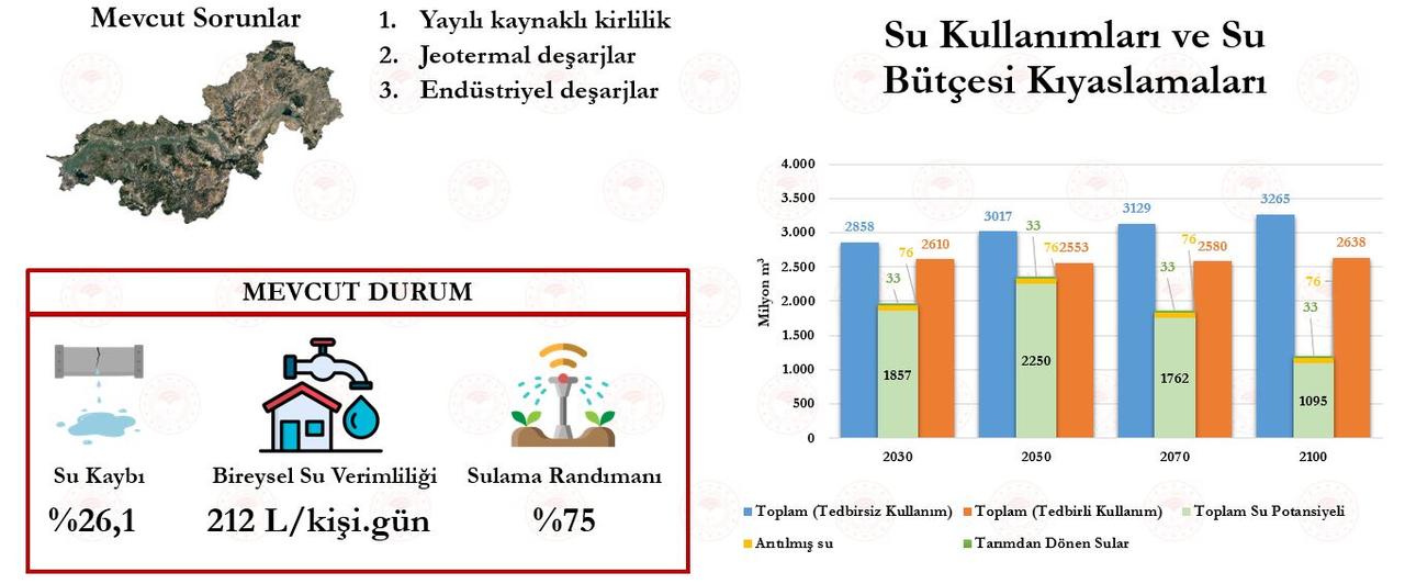
Mevcut Sorunlar ( T.C. Tarım ve Orman Bakanlığı Su Yönetimi Genel Müdürlüğü)
One of the most significant environmental problems in the region is pollution of water resources. The Great Menderes River is contaminated by waste from surrounding agricultural activities, industrial facilities, and settlements. Chemical fertilizers and pesticides used in agriculture seep into river water, degrading its quality. Industrial and domestic wastewater further contribute to river pollution.
In the Great Menderes Basin, particularly in mountainous areas, soil erosion is a serious problem. Deforestation and improper farming practices lead to soil being washed away by water, resulting in the loss of fertile agricultural land. This reduces productivity in agriculture-dependent settlements and threatens biodiversity. Additionally, inappropriate irrigation methods and deforestation accelerate desertification processes.
Considering the high intensity of agricultural and industrial activities in the basin, overuse of water resources is another major environmental issue. Declining groundwater levels, unrestricted extraction of water for irrigation, and reduced river flows are disrupting the region’s water balance. This threatens the sustainability of agriculture and negatively affects water quality.
Global climate change has marked effects on agriculture and water resources in the Great Menderes Basin. Rising temperatures accelerate evaporation, leading to lower groundwater levels. Prolonged drought periods further reduce the availability of water needed for irrigation. This negatively impacts agricultural productivity and threatens the region’s economic structure.
The Great Menderes Basin hosts a variety of flora and fauna species. However, intensive agricultural practices, deforestation, and water pollution have led to a decline in biological diversity. The destruction of habitats for certain endemic plant and animal species disrupts ecosystem balance and risks their extinction.
Various conservation and sustainable development projects have been developed to address environmental challenges in the Great Menderes Basin. These initiatives aim to protect the region’s ecosystem, ensure sustainable use of water resources, and promote environmentally friendly agricultural practices.
Water management is one of the most critical conservation areas in the region. Irrigation projects and water conservation techniques are the main efforts aimed at efficient water use. Additionally, awareness campaigns are conducted to discourage water-intensive farming methods and protect groundwater resources. Rainwater harvesting systems and drip irrigation methods are among the approaches that optimize water use.
To prevent soil erosion, reforestation and soil rehabilitation projects are implemented. Farmers are educated to adopt sustainable agricultural practices and reduce the use of harmful agrochemicals. Biodiversity conservation areas and natural habitat restoration projects also contribute to combating erosion.
To protect biodiversity in the Great Menderes Basin, several nature parks and conservation areas have been established. These areas safeguard endemic plant and animal species. Furthermore, promoting organic farming methods to align agricultural activities with ecosystem needs is essential.
Educational programs are organized for local communities and farmers to raise environmental awareness. These programs provide information on environmentally friendly farming practices, water conservation techniques, and biodiversity protection strategies. Additionally, awareness campaigns on environmental issues are conducted through collaboration between local authorities and civil society organizations.
Akdeniz, Engin. "Büyük Menderes Havzasında Prehistorik Yerleşim Dokusu." BELLETEN 66, no. 245 (2002): 1-34.
Sütgibi, Semra. "BÜYÜK MENDERES HAVZASININ SICAKLIK, YAĞIŞ VE AKIM DEĞERLERİNDEKİ DEĞİŞİMLER VE EĞİLİMLER." Marmara Coğrafya Dergisi, no. 31 (January 2015): 398-414.
T.C. Ministry of Agriculture and Forestry. *Büyük Menderes Havzası Tanıtım Raporu*. Ankara: Su Yönetimi Genel Müdürlüğü, 2023. Accessed May 5, 2025.Accessed adresi
T.C. Ministry of Agriculture and Forestry. *Mevcut Sorunlar Görseli.* Ankara: Su Yönetimi Genel Müdürlüğü, 2023. Accessed May 7, 2025.Büyük Menderes Havzası

Great Menderes Basin
Surface Area | 25,987 km² | ||||||||
|---|---|---|---|---|---|---|---|---|---|
Distribution by Provinces | Denizli (%32.09) Aydın (%29.28) Muğla (%9.50) Uşak (%13.94) Afyonkarahisar (%12.61) | ||||||||
Main River | Büyük Menderes Nehri | ||||||||
River Length | Approximately 600 km | ||||||||
Major Tributaries | Akçay Çine Çayı Dandalas Çayı Banaz Çayı More than 50 small and large streams | ||||||||
Surface Water Status | Only 9% of the 134 surface water bodies are in good or very good condition; 72 have not been monitored at all. | ||||||||
Groundwater Status | Seven of the 38 groundwater bodies have been assessed as being in 'poor' condition. | ||||||||
No Discussion Added Yet
Start discussion for "Great Menderes Basin" article
Geographical Structure
Hydrography
Economic Use and Agricultural Activities
Agriculture
Livestock Farming
Industry and Other Economic Activities
Environmental Issues and Conservation Efforts
Water Pollution
Soil Erosion and Desertification
Overuse of Water Resources
Climate Change and Rising Temperatures
Loss of Biodiversity
Conservation Efforts
Water Resource Management
Soil Conservation and Erosion Control
Biodiversity Conservation
Education and Awareness