This article was automatically translated from the original Turkish version.
+2 More
Official Name | GIUK Gap (Greenland-Iceland-United Kingdom Passage) | ||||||||
|---|---|---|---|---|---|---|---|---|---|
Geographical Location | North Atlantic Ocean; the connection point between the Arctic Ocean and the Atlantic Ocean | ||||||||
Area Covered | Marine areas between Greenland, Iceland and the United Kingdom | ||||||||
Military Operational Importance | Primary route providing year-round ice-free access to the Atlantic for Russia's Northern Fleet Center of NATO's Anti-Submarine Warfare (ASW) and underwater surveillance operations | ||||||||
Key Surveillance Technologies | SOSUS: Sound Surveillance System (underwater hydrophone network) Air Assets: P-8 Poseidon maritime patrol aircraft and RQ-4D Phoenix unmanned aerial vehicles Unmanned Systems: Orca Extra Large Unmanned Underwater Vehicle (XLUUV) | ||||||||
Strategic Partners | United States, Canada, Denmark, Norway, Iceland, the United Kingdom, and new members Finland and Sweden | ||||||||
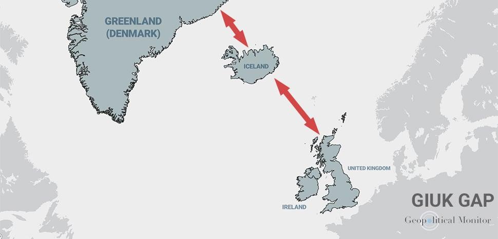
GIUK Gap (Greenland-Iceland-United Kingdom Passage), is a strategically significant maritime transit zone located in the North Atlantic Ocean that connects the Arctic Ocean to the Atlantic Ocean.【1】
The GIUK Gap is a natural chokepoint and strategic passage encompassing the maritime areas between Greenland, Iceland and the United Kingdom. Although this passage covers a broader area than classic narrow straits such as Gibraltar or Hormuz Strait, it still constitutes a constraining boundary for maritime forces seeking to enter the Atlantic.
The region is a critical focal point for maritime strategists due to its role in facilitating sea traffic between North America and Europe and linking Northern European waters to the broader oceanic expanse. The geographical configuration of the passage provides advantageous observation points for parties seeking to defend North Atlantic sea lanes against threats originating from the north.【2】
The military and naval significance of the region dates back to World War I and played a vital role during World War II in safeguarding transatlantic supply routes. Allied forces occupied Iceland and Greenland to establish surveillance bases aimed at preventing German submarines (U-boats) and surface ships from disrupting Atlantic shipping lanes.
During the Cold War, the GIUK Gap became the primary "chokepoint" and forward defensive line used by NATO to detect Soviet submarines. During this period, NATO deployed underwater hydrophone networks known as the Sound Surveillance System (SOSUS) and maritime patrol aircraft such as the P-3 Orion to monitor Soviet efforts to penetrate from the Kola Peninsula into the Atlantic.【3】
Russia considers the GIUK Gap the primary route through which its Northern Fleet maintains year-round ice-free access to the North Atlantic. Russia’s naval strategy is built around its nuclear submarine fleet, which operates from the Kola Peninsula and the Barents Sea and projects power through this passage.
In recent years, Russia has sought to strengthen its naval dominance by introducing advanced submarines of the Yasen and Borei classes equipped with stealth technology, as well as Kalibr cruise missiles and Zircon hypersonic missiles into the region. Additionally, melting Arctic ice caps are expanding Russia’s operational area, enabling it to bypass traditional chokepoints and gain direct access to the Atlantic via the GIUK Gap.【4】
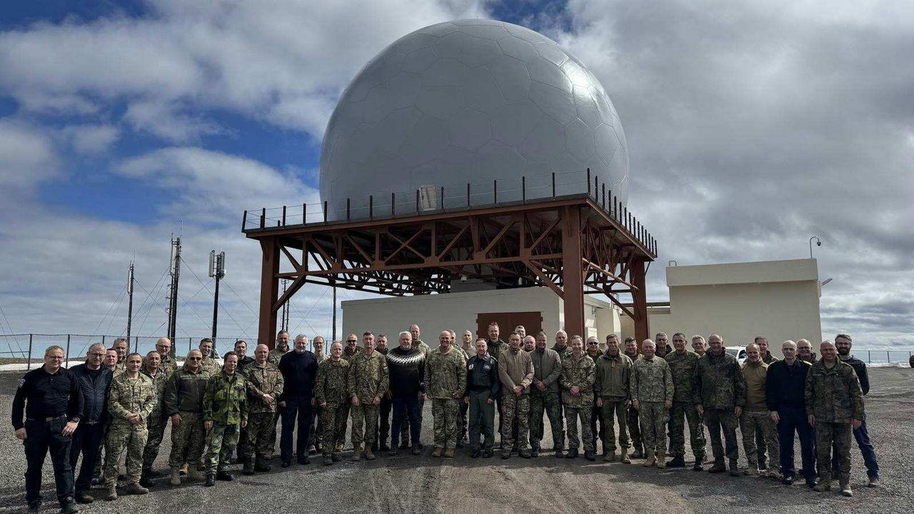
NATO Military Committee Visits Iceland (NATO)
After the collapse of the Soviet Union, NATO reduced its focus on the region but has since revitalized its anti-submarine warfare (ASW) capabilities in response to increased Russian naval activity. As part of this effort, the presence of P-8 Poseidon maritime patrol aircraft in Iceland has been expanded, and investments have been made in unmanned underwater systems such as the Orca XLUUV for enhanced submarine surveillance.
Within NATO’s defense architecture, the Joint Force Command Norfolk and the U.S. Second Fleet assume central roles in securing transatlantic sea lines of communication (SLOCs). Iceland, with its modernized air base and radar centers at Keflavik, continues to serve as NATO’s “eyes and ears” in the North.【5】
The GIUK Gap is a focal point for hybrid warfare threats due to its critical undersea communication cables, which carry 95% of global internet traffic, and open-sea energy infrastructure. Russia’s capability to conduct sabotage against these vital cables and pipelines using specialized vessels such as the Yantar and remotely operated underwater vehicles poses a direct risk to the economic and financial stability of NATO member states. This has necessitated expanding situational awareness in the region beyond mere naval vessel tracking to include comprehensive undersea infrastructure security.【6】
Melting ice due to climate change is reshaping Arctic geopolitics and enhancing the strategic value of the GIUK Gap. New trade routes, including the Northern Sea Route (NSR), are transforming the region into a global transportation corridor. NATO aims to enhance situational awareness by extending its Intelligence, Surveillance and Reconnaissance (ISR) operations into the GIUK Gap from advanced forward bases such as Finland, using long-endurance unmanned aerial systems such as the RQ-4D Phoenix.【7】
Aguiar, Paulo. "Geopolitics of the GIUK Gap: Past, Present, and Future." Geopolitical Monitor. Accessed June 26, 2026. https://www.geopoliticalmonitor.com/geopolitics-of-the-giuk-gap-past-present-and-future/
Demirayak, Özgür, and Davut Ateş. 2024. “Nato’nun Yüksek Kuzey’deki Rolü Ve Yetenekleri”. Paradigma: İktisadi ve İdari Araştırmalar Dergisi 13 (Özel Sayı): 112–28. Accessed June 26, 2026. https://izlik.org/JA56WE93TX
IISS. "The GIUK Gap’s strategic significance." Accessed June 26, 2026. https://www.iiss.org/publications/strategic-comments/2019/the-giuk-gaps-strategic-significance/
NATO. "Less Transit, More Surveillance: NISRF Extends GIUK Mission from the High North." Accessed June 26, 2026. https://nisrf.nato.int/home/newsroom/news-2025/less-transit--more-surveillance-nisrf-extends-giuk-mission-from-the-high-north
NATO. "NATO Military Committee visits Iceland." Accessed June 26, 2026. https://www.nato.int/en/news-and-events/articles/news/2026/06/03/nato-military-committee-visits-iceland.
[1]
Aguiar, Paulo "Geopolitics of the GIUK Gap: Past, Present, and Future" Geopolitical Monitor. Access Date 26 June 2026. https://www.geopoliticalmonitor.com/geopolitics-of-the-giuk-gap-past-present-and-future/
[2]
Aguiar, Paulo "Geopolitics of the GIUK Gap: Past, Present, and Future" Geopolitical Monitor. Access Date 26 June 2026. https://www.geopoliticalmonitor.com/geopolitics-of-the-giuk-gap-past-present-and-future/
[3]
IISS. "The GIUK Gap’s strategic significance" Access Date 26 June 2026. https://www.iiss.org/publications/strategic-comments/2019/the-giuk-gaps-strategic-significance/
[4]
Aguiar, Paulo "Geopolitics of the GIUK Gap: Past, Present, and Future" Geopolitical Monitor. Access Date 26 June 2026. https://www.geopoliticalmonitor.com/geopolitics-of-the-giuk-gap-past-present-and-future/
[5]
Demirayak, Özgür, and Davut Ateş. 2024. “NATO’s Role and Capabilities in the High North”. Paradigma: Journal of Economic and Administrative Research 13 (Special Issue): 116 https://izlik.org/JA56WE93TX.
[6]
NATO. "Less Transit, More Surveillance: NISRF Extends GIUK Mission from the High North." Access Date 26 June 2026. https://nisrf.nato.int/home/newsroom/news-2025/less-transit--more-surveillance-nisrf-extends-giuk-mission-from-the-high-north
[7]
NATO. "Less Transit, More Surveillance: NISRF Extends GIUK Mission from the High North." Access Date 26 June 2026. https://nisrf.nato.int/home/newsroom/news-2025/less-transit--more-surveillance-nisrf-extends-giuk-mission-from-the-high-north


Official Name | GIUK Gap (Greenland-Iceland-United Kingdom Passage) | ||||||||
|---|---|---|---|---|---|---|---|---|---|
Geographical Location | North Atlantic Ocean; the connection point between the Arctic Ocean and the Atlantic Ocean | ||||||||
Area Covered | Marine areas between Greenland, Iceland and the United Kingdom | ||||||||
Military Operational Importance | Primary route providing year-round ice-free access to the Atlantic for Russia's Northern Fleet Center of NATO's Anti-Submarine Warfare (ASW) and underwater surveillance operations | ||||||||
Key Surveillance Technologies | SOSUS: Sound Surveillance System (underwater hydrophone network) Air Assets: P-8 Poseidon maritime patrol aircraft and RQ-4D Phoenix unmanned aerial vehicles Unmanned Systems: Orca Extra Large Unmanned Underwater Vehicle (XLUUV) | ||||||||
Strategic Partners | United States, Canada, Denmark, Norway, Iceland, the United Kingdom, and new members Finland and Sweden | ||||||||
Geostategic Location and Definition
Historical Development and 20th Century Strategies
Russian Federation’s Strategic Interests in the Region
NATO’s Defense and Deterrence Capabilities
Hybrid Warfare and Critical Infrastructure Security
Arctic and Climate Change Impact