


This article was automatically translated from the original Turkish version.
+1 More
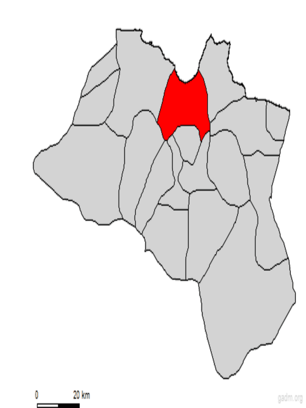
Fatsa (District)
Province | Ordu | ||||||||
|---|---|---|---|---|---|---|---|---|---|
Geographic Region | Black Sea | ||||||||
Population | 128359 (2024) | ||||||||
District Governor | Avni KULA | ||||||||
Mayor | İbrahim Etem KİBAR | ||||||||
Ordu is a district belonging to the province of Fatsa, located along the coast of the Black Sea Region in the eastern part of the region. With its natural beauty, historical heritage, advanced agriculture, and trade, it is one of the region’s most significant settlement centers. Fatsa attracts attention due to its favorable location for both sea and land transport, and it holds a prominent place among Ordu’s dynamic districts through its cultural diversity, local economy, and modern urban structure.
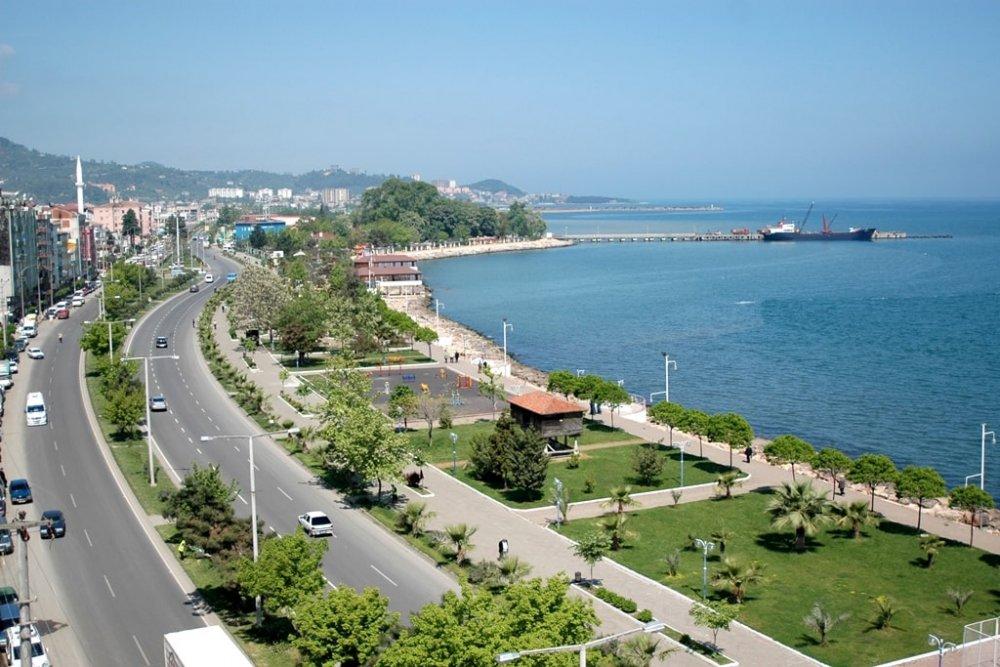
Fatsa (Fatsa Municipality)
Fatsa and its surroundings served as a home to indigenous communities such as the Colchians, Drilae, Halizones, Mossynoecians, and Tibarenes during the 4th century BCE. Although traces from this period are believed to be concentrated around Çıngırt Rock in the Yapraklı locality, these claims lack scientific foundation. Further archaeological research in the region is expected to provide clearer information.
From 675 BCE, the region came under the control successively of the Cimmerians, Persians, and Alexander the Great along with his commanders. However, Fatsa’s most significant historical period coincides with the Kingdom of Pontus. Between 280 BCE and 263 CE, this era strengthened the region, and it is said that Pharnaces II ruled from Fatsa and built a castle in the name of his daughter Phanis. For this reason, the region was known for a time as “Phanis.” Over time, this name evolved into forms such as Fanise, Phadsane, Pytane, and Faça, eventually becoming Fatsa. Claims that Fatsa was the capital of the Pontic state, however, lack historical evidence.
Following the dissolution of the Kingdom of Pontus by Rome in 63 CE, the region became part of the Byzantine territories in 395 CE. In the 11th century, invasions by the Pecheneg and Cuman Turks into Anatolia also affected the Fatsa area.
The permanent settlement of Turks in the region occurred after the Battle of Manzikert in 1071. Sevli Bey, one of the Danişmentids, conquered the Black Sea coast including Fatsa. Among the Turkic tribes settling in the region, the Çepniler were the most prominent. In the 1380s, the Hacıemiroğulları Beylik gained control over Fatsa, and in 1427–1428, the region was incorporated into Ottoman territory following the Canik Campaign led by Yörgüç Paşa.
During the 13th and 14th centuries, Genoese commercial activities were evident along the coast, and Fatsa became one of the Black Sea’s important trade centers. The Genoese used a coastal fortress as a warehouse. Genoese dominance in the Black Sea ended during the reign of Fatih Sultan Mehmet.
During the Ottoman period, Fatsa was a settlement under the Canik Sanjak. Initially known as “Satılmış-ı Mezid Bey,” the region became a nahiye in the 15th century and attained kaza status from the 16th century onward. Records from the 17th century indicate six distinct kazas in the region. According to Katip Çelebi, Fatsa and Vonayı were among them.
From the second half of the 16th century, the Fatsalı Caniklizade family exerted influence in the Canik region. In the 19th century, administrative changes occurred: between 1869 and 1872, Fatsa was subordinate to Ünye as a nahiye, but it regained kaza status in 1878.
On 30 November 1920, the establishment of the Ordu and Giresun sanjaks was discussed in the Grand National Assembly of Türkiye, and on 4 December 1920, the Ordu Sanjak was created. Fatsa and Ünye kazas were attached to this new sanjak. Although the populations of Ünye and Fatsa opposed this decision, their appeals were rejected, and Fatsa officially became a kaza under Ordu.
Fatsa is a district of the province of Ordu in Türkiye’s Black Sea Region, situated between 41° North latitude and 37°–38° East longitude. To the east lies Perşembe, to the west Ünye, and to the south Korgan, Çamaş, Çatalpınar, and Kumru districts. The northern boundary of Fatsa is formed by the Black Sea.
The district is generally mountainous and rugged in terrain. Elevation ranges from sea level up to 550 meters. The Canik Mountains, running parallel to the Black Sea coast, gradually descend toward the shoreline. The important rivers of the district, Bolaman and Elekçi streams, create flat areas near the coast.
The main rivers flowing within Fatsa’s boundaries are Bolaman Stream, Elekçi Stream, Şerefiye Stream, and Kurtuluş Mahallesi Stream. The most important natural lake in the region is Gaga Lake, located within the boundaries of Örencik Village, 10 kilometers southeast of the district.
Settlement in Fatsa occurs both along the coastal alluvial plain and on the sloping terrains further inland. Based on excavation data from the slopes, no groundwater has been detected in these areas. The flatlands, however, consist of fine sand and clay soils that contain groundwater. The upper soil layer on the slopes is 1.5–2 meters thick, composed of clay and vegetation cover, while the underlying layer consists of fractured blue limestone.
Agricultural areas in the district consist of lowland terrains along stream beds and sloping lands. Agricultural activities are carried out in areas containing Class I and III soils. Approximately 80 percent of arable land is used for hazelnut cultivation. Higher-altitude slopes are covered with forested areas, and due to the steep topography, conversion of these forests into agricultural land is rare.
Fatsa experiences a typical Black Sea climate. Winters are mild and summers are cool and humid. Annual temperature variations are low. Humidity remains high throughout the year, and rainfall is evenly distributed.
As of 31 December 2024, Fatsa’s population is 128,359. Women constitute 51 percent of the population and men 49 percent. The population density of the district is calculated at 349.30 persons per square kilometer.
When analyzed by age group, individuals in the middle-aged group (48 percent) form the largest segment of Fatsa’s population. This is followed by the youth population (34 percent) and the elderly population (18 percent). This distribution indicates that the working-age population is dominant and the active labor force is at a high level.
The majority of the population resides in the district center, but a significant population also lives in rural neighborhoods. Although age distribution is relatively balanced, the dominance of the middle-aged group is decisive for medium- and long-term planning in social services, healthcare, and education.
The district’s economy is based on agriculture and fishing. Major agricultural products include hazelnuts, tea, and maize. Additionally, cultivation of apples and pears, along with vegetables and fruits, is practiced, and greenhouse farming and cultivation of mushrooms are becoming increasingly common. Livestock farming includes both large and small ruminants, as well as poultry farming and beekeeping. Fishing is one of the primary sources of livelihood in Fatsa, and traditional carpet weaving and hazelnut cracking workshops also contribute to the local economy. The district has one organized industrial zone, and industrial investments are increasing.
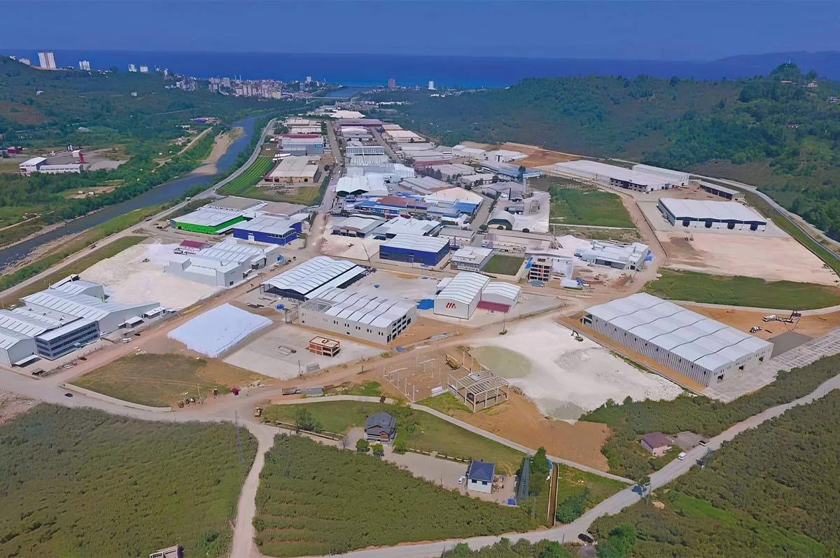
Fatsa Organized Industrial Zone (Fatsa OSB)
In addition to primary and secondary educational institutions, Fatsa hosts higher education institutions affiliated with Ordu University, namely the Fatsa Faculty of Marine Sciences and the Vocational School. Cultural activities in the district are organized by the municipality and local associations. Additionally, folk dances, traditional weddings, and regional festivals reflect the cultural richness of the area.
Fatsa lies along the Black Sea Coastal Road. This road provides strong road connections to major cities such as Ordu, Samsun, and Trabzon. Although sea transport is not utilized within the district, it is approximately 60 kilometers from Ordu-Giresun Airport. The district’s bus terminal provides access to surrounding provinces and districts.
Fatsa’s natural attractions include Gaga Lake, Çerkezler Hill, Bolaman Castle, and Yalıköy Beach. Additionally, the town of Bolaman is an important historical tourism center, featuring Ottoman-era civil architecture and the Bolaman Mansion. The district offers suitable areas for nature hiking and highland tourism. Fatsa is also fortunate in terms of natural underground resources: the town of Ilıca has medicinal water known to be beneficial for rheumatism, back pain, and kidney disorders. In Elmaköy, Acısu water is known to have curative properties for various ailments.
Fatsa is one of the important port cities of the Black Sea that has hosted numerous civilizations throughout history. Archaeological excavations in the district and its surroundings have uncovered traces of ancient settlements. Particularly in Bolaman Neighborhood, Roman and Byzantine-era artifacts have been discovered. Additionally, Hellenistic-era coins and ceramic fragments have been unearthed. These historical layers ensure that Fatsa attracts attention not only for its natural beauty but also for its cultural heritage.
Located approximately 9 kilometers from Fatsa district center along the Ordu–Fatsa road, the Bolaman neighborhood stands out for its historical structure. This structure has become a symbol of the region, distinguished not only by its architecture but also by its presence in cultural imagery. This monument, photographed by hundreds of visitors annually, appears visually on numerous objects ranging from tourist souvenirs to matchboxes.
The historical structure incorporates elements from two distinct periods. The first phase consists of stone walls dating back to the early centuries of the Common Era. These stone walls were originally constructed as a defensive structure on a small island surrounded by water on all sides. The structure, along with its walls, exhibits characteristics of a castle and is believed to have housed a church within its confines. In this respect, it represents a typical example of early defensive and religious architecture.
The second phase is an wooden mansion built during the Ottoman period. This mansion was constructed on top of the existing stone walls in the late 18th century. It is believed to have been commissioned by Mehmet Bey, son of Büyük Ali Bey of the Hazinedar family. With a history of approximately two hundred years, the mansion exhibits characteristic features of Ottoman civil architecture.
Hazinedaroğlu Mansion has been officially registered as a historical monument by the General Directorate of Monuments and Museums under the Ministry of Culture and Tourism and is recognized as cultural heritage requiring preservation. The mansion and its ruins, described by the same directorate as “a typical example of old Turkish architecture,” are among the rare surviving examples in the Black Sea Region that have maintained their architectural integrity. Efforts to restore the structure for preservation and transmission to future generations have been initiated by the Black Sea Technical University.
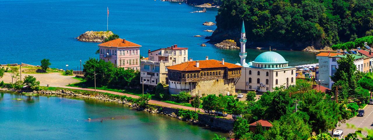
Bolaman Castle and Hazinedaroğlu Mansion (Fatsa Subgovernorship)
In the area of Dumlupınar Neighborhood, currently occupied by a prison, lies a site known locally as “Manastır,” where ruins of a castle allegedly built by Kont Polenon are found. Although the structure itself has not survived to the present day, it remains preserved in local memory as “manastır.” While no definitive information exists regarding its original function or architectural details, the historical nature of the site reflects the cultural diversity of the region.
To the west of Fatsa district, within the boundaries of Evkaf Village and approximately five kilometers from the district center, remains of a castle, mansion, church, and monastery from the Pontic period have been discovered. These ruins indicate that a large settlement once existed in the area. Surface surveys in the region have uncovered silver coins bearing inscriptions indicating that, at one time, Derebeyi Hacı Şevda ruled here and minted coins in his name. This information reveals the area’s historical significance both politically and economically.
Located west of the district center, in the area where Görevi Stream flows, the Cıngırt Rock Graves are among structures believed to belong to an ancient castle. The site is situated on a hill approximately five kilometers away and contains a rocky tunnel with a 45-degree incline descending toward Elekçi Stream. Inside the tunnel is a staircase of 120 steps carved into a large rock. This hidden passage is thought to have been constructed to connect the castle on the hill to Elekçi Stream. The site holds great archaeological importance.
Located approximately 10 kilometers from Fatsa district, the Sarmaşık Hot Springs are one of the region’s key health tourism centers due to their natural therapeutic properties and accessibility. Chemical analyses show that one liter of the 47°C spring water contains 0.731 grams of sulfur compounds, 0.1755 grams of sodium chloride, 0.253 grams of calcium salts, 0.005 grams of silica, and 1.433 grams of gelatinous substance (yeluse essence). The water is colorless, odorless, and has a mild mineral taste, with a flow rate of 200 liters per minute. It has long been used by the local population for treating various skin and rheumatic conditions.
One of Fatsa’s most vibrant tourism areas is Yalıköy, which attracts both domestic and foreign tourists during summer months with its long shoreline and natural coves. With its fine sandy beaches and clear sea, it is one of the rare coastal areas in the Black Sea with significant beach tourism potential. Additionally, coastal excursions organized by small fishing boats are among the popular activities for visitors.
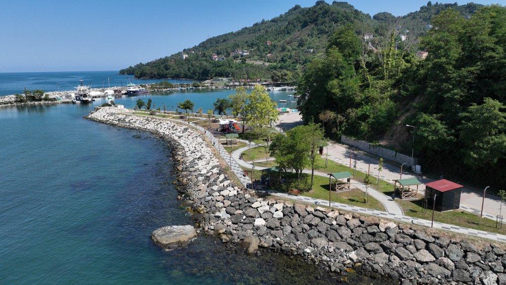
Yalıköy Shoreline (Fatsa Municipality)
Located 10 kilometers southeast of Fatsa district, within the boundaries of Örencik Village, Gaga Lake is a small freshwater lake covering approximately 15,000 square meters. Surrounded by dense forest and trees, the lake draws attention for its natural landscape and tranquil character. In the center of the lake is a very small islet. Local folklore suggests that a church once stood on this islet in earlier times, but these claims have not yet been supported by archaeological or historical evidence. Access to the lake shore by motor vehicles is possible, making Gaga Lake an attractive destination for nature walks and rural tourism.
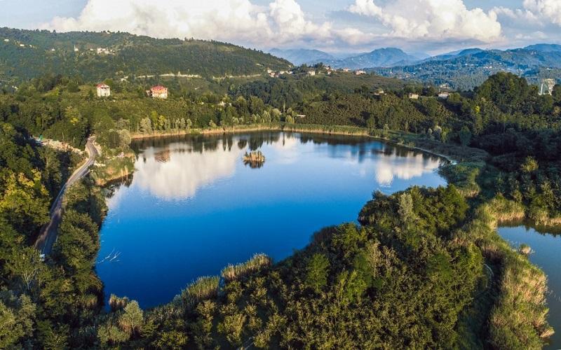
Fatsa Gaga Lake (Fatsa Subgovernorship)
Although Fatsa and its surroundings were not occupied during the War of Independence, the district served as one of the organizational centers of local resistance movements. Local monuments and commemorative events in this context help sustain national consciousness in the district and serve as a resource for educational and historical tourism.
Traditional Black Sea culture prevails in Fatsa. Family structure generally follows the extended family model. Cultural diversity has increased due to migration from other regions. Social life in the district revolves around tea gardens, cafes, marketplaces, and coastal promenades.
Fatsa Belediyesi Resmî Web Sitesi. Accessed April 14, 2025.https://www.fatsa.bel.tr
Fatsa Kaymakamlığı. "Bolaman Kalesi ve Hazinedaroğlu Konağı." Accessed April 14, 2025.http://www.fatsa.gov.tr/bolaman-kalesi-ve--hazinedaroglu-konagi
Fatsa Kaymakamlığı. "Gaga Gölü." Accessed April 14, 2025.http://www.fatsa.gov.tr/gaga-golu
Fatsa Organize Sanayi Bölgesi Resmî Web Sitesi. Accessed April 14, 2025.https://www.fatsaosb.org.tr/
Ordu İl Kültür ve Turizm Müdürlüğü. "Fatsa." Accessed April 14, 2025.https://ordu.ktb.gov.tr/TR-67377/fatsa.html
T.C.Fatsa Belediyesi. "Eski Fatsa Fotoğrafları." Accessed April 14, 2025.https://www.fatsa.bel.tr/fotograf/eski-fatsa-fotograflari
T.C.Fatsa Belediyesi. "Fatsa Fotoğrafları." Accessed April 14, 2025.https://www.fatsa.bel.tr/fotograf/fatsa-fotograflari
TÜİK, Adrese Dayalı Nüfus Kayıt Sistemi (ADNKS), 2024. Accessed April 14, 2025.
Fatsa (District)
Province | Ordu | ||||||||
|---|---|---|---|---|---|---|---|---|---|
Geographic Region | Black Sea | ||||||||
Population | 128359 (2024) | ||||||||
District Governor | Avni KULA | ||||||||
Mayor | İbrahim Etem KİBAR | ||||||||
History
Ottoman Period (1427–1922)
Pre-Republican Developments
Geography
Location
Topography
Hydrography
Geology
Soil and Land Use
Climate
Population and Demographic Structure
Economy
Education and Culture
Transportation
Tourism Potential
Bolaman Castle and Hazinedaroğlu Mansion
Monastery Ruins in Dumlupınar Neighborhood
Göreği Monastery and Ancient Settlement Ruins
Cıngırt Rock Graves
Sarmaşık Hot Springs
Yalıköy and Its Beaches
Gaga Lake
Martyrs’ Monument and National Resistance Traces
Social Structure