This article was automatically translated from the original Turkish version.
+1 More
Settlement Type | Ionian urbanization, terraced settlement | ||||||||
|---|---|---|---|---|---|---|---|---|---|
Period | Early Bronze Age – Byzantine Period | ||||||||
Location | İzmir Province Çeşme District Ildırı Neighborhood | ||||||||
Economy | Maritime trade Stone production | ||||||||
Erythrai Ancient City is an Ionian settlement located within the boundaries of Ildırı Village, Çeşme District, İzmir Province, on the western Anatolian coastline【1】. The ancient city developed on a peninsula with direct maritime access, situated on the western part of the Urla Peninsula. Architectural remains of the settlement largely overlap with the modern village of Ildırı. The city is approximately 20 km from the Çeşme district center【2】.
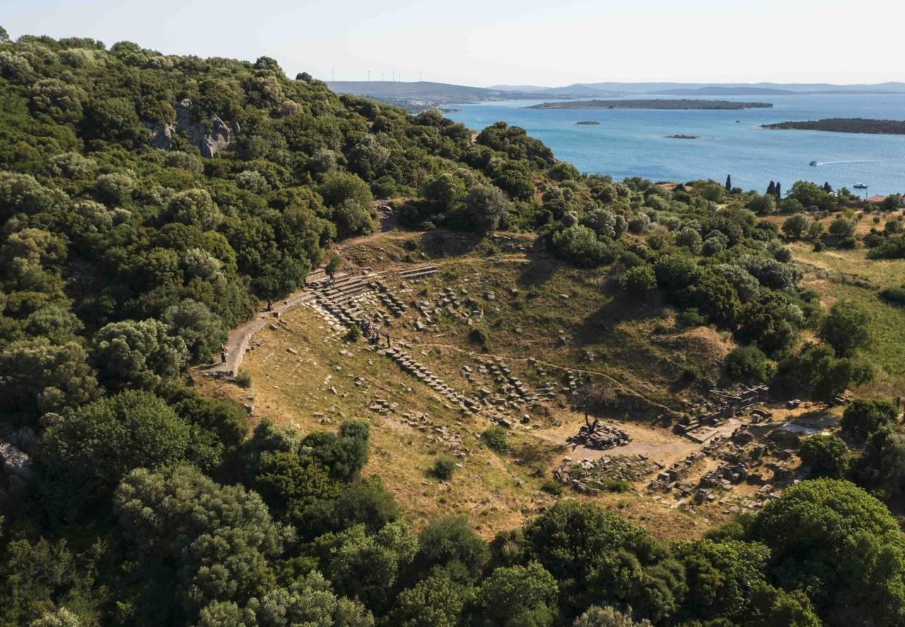
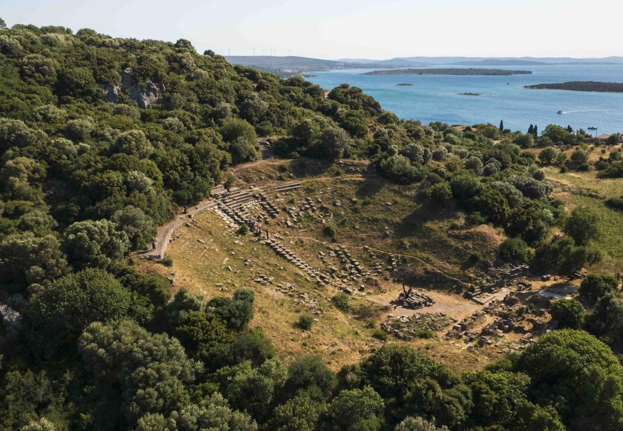
Erythrai Ancient City (Cultural Portal)
The settlement area is bordered by elevated terrain to the north and east, and by open coastal zones to the south and west. Natural bays and indentations along the coastline provided favorable conditions for maritime access and harbor use in antiquity. The harbor area was constructed on a natural bay approximately 150–200 meters wide.
The settlement is surrounded by hilltops reaching 60–80 meters in elevation to the northeast, while its southwestern coastline is directly connected to the sea.
Evidence of settlement at Erythrai extends back to the Early Bronze Age【3】. During the Archaic period, the city was established as an Ionian settlement, and construction activity intensified during the Classical and Hellenistic periods. Public spaces remained in use during the Roman period, while settlement during the Byzantine period was confined to a more limited area.
The city’s layout follows a terraced system adapted to the natural topography. The theater was built into the slope, with seating carved directly from the bedrock. It had a capacity of approximately 800–1000 spectators. Construction of the theater is dated to the 3rd century BCE【4】.
The Temple of Athena on the acropolis was first constructed in the second half of the 8th century BCE and expanded with additions in subsequent centuries【5】. The Kore statue found near the temple is dated to the 6th century BCE【6】. The acropolis area covers a total of 1.2 hectares.
The city was enclosed by walls approximately 5 km in length【7】. Some sections of the walls reach heights of up to 5 meters【8】. The earliest phases of the wall construction date to the 4th century BCE, while the main sections were built during the 3rd–2nd centuries BCE【9】.
Several stone quarries have been identified around the city【10】. The stone extracted from these quarries was used primarily in the city walls as well as in public and private buildings. The stone blocks show regular cutting marks, and their dimensions were standardized for architectural use【11】. The quarries operated as part of an integrated production and utilization system directly linked to the city.
Sacred areas played a significant role in urban life at Erythrai. The city is associated with the cult of Apollo, and written and archaeological evidence indicates the presence of female priestesses【12】. This highlights a distinctive feature of the city’s religious practices.
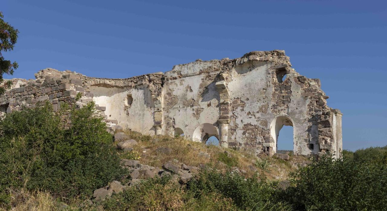
Erythrai Ancient City (Cultural Portal)
During the second-generation excavations conducted by Ankara University at Erythrai Ancient City, a sacred area dedicated to the mother goddess Kybele was uncovered and officially registered as a first-degree archaeological site for protection【13】. As a result, the boundaries of the site were expanded and specific conservation conditions and usage restrictions were established.
Following its registration, the site boundaries were extended and conservation conditions and usage limitations were defined.
The Kybele sacred area covers approximately 0.8 hectares and contains stone-based platforms, ritual spaces, and small structures. Excavations revealed that the main architectural elements of the area are preserved, with large portions of stone pavements and foundations still standing. Small archaeological finds indicating ritual and ceremonial use have also been identified【14】.
Following its registration, protection and monitoring mechanisms were implemented in publicly accessible areas, and restrictions were imposed on construction and land use in the surrounding zone【15】. The Kybele sacred area is regarded as the center of religious life at Erythrai and is considered part of a ritual network connecting other sacred areas and temples within the ancient city. This underscores its importance in revealing the role of female priestesses and the cult of the mother goddess within Ionian religious practices【16】.
Erythrai’s economic activities are understood to have been linked to maritime trade and stone production. Thanks to its harbor connections, the city maintained relations with the Aegean world, while local stone production was intensively used in urban construction.
Excavations and surface surveys at the site have provided detailed documentation of defensive structures, quarries, and the urban fabric. Research on the quarries has particularly revealed insights into Erythrai’s architectural production capacity and building technology【17】.
Architectural remains of the ancient city are visible in open areas today. The site is designated as an archaeological protected area, and ongoing research continues at the location.
Altın Rota. “İyon Gezginleri 7: Erythrai – Kadın Kâhinlerin Kenti.” Accessed January 29, 2026.https://www.altinrota.org/yazilar/iyon-gezginleri-7-eriytrai-kadin-kahinlerin-kenti/224
Ankara Üniversitesi Culture Research Application and Research Center (ANKÜSAM). "Erythrai." Accessed January 29, 2026.https://ankusam.ankara.edu.tr/erythrai/
GZT Seyahat. “Erythrai Antik Kenti'nde Kybele kutsal alanı 1. derece sit oldu.” Accessed January 29, 2026.https://www.gzt.com/seyahat/erythrai-antik-kentinde-kybele-kutsal-alani-1-derece-sit-oldu-3710608
T.C. Ministry of Culture and Tourism, Turkey Culture Portal. "Erythrai Antik Kenti." Accessed January 29, 2026.https://www.kulturportali.gov.tr/turkiye/izmir/gezilecekyer/erythrai-antik-kenti-
Tulga Albustanlıoğlu. “Erythrai (Ildırı) Antik Kenti Taş Ocakları: Yeni Bulgular.” *Arkeoloji ve Sanat* 161 (2019): 91–106.https://www.researchgate.net/publication/356586510_Erythrai_Ildiri_Antik_Kenti_Tas_Ocaklari_Yeni_Bulgular_Arkeoloji_ve_Sanat_Dergisi_2019_16191-106
Türkiye Turizm Ansiklopedisi. "Erythrai Örenyeri ve Kazıları." Accessed January 29, 2026.https://turkiyeturizmansiklopedisi.com/erythrai-orenyeri-ve-kazilari
İzmir Kültür. "Erythrai Antik Kenti." Accessed January 29, 2026.https://izmirkultur.com/izmir-erythrai-antik-kenti/
İzmir İl Kültür ve Turizm Müdürlüğü. "Erythrai (Ildırı) – Çeşme." Accessed January 29, 2026.https://izmir.ktb.gov.tr/TR-210590/erythrai-ildiri-cesme.html
[1]
Türkiye Turizm Ansiklopedisi, “Erythrai Örenyeri ve Kazıları,” erişim 29 Ocak 2026, https://turkiyeturizmansiklopedisi.com/erythrai-orenyeri-ve-kazilari
[2]
Türkiye Turizm Ansiklopedisi, “Erythrai Örenyeri ve Kazıları,” erişim 29 Ocak 2026, https://turkiyeturizmansiklopedisi.com/erythrai-orenyeri-ve-kazilari
[3]
Ankara Üniversitesi Kültür Araştırmaları Uygulama ve Araştırma Merkezi (ANKÜSAM), “Erythrai,” erişim 29 Ocak 2026, https://ankusam.ankara.edu.tr/erythrai/
[4]
İzmir İl Kültür ve Turizm Müdürlüğü, “Erythrai (Ildırı) – Çeşme,” erişim 29 Ocak 2026, https://izmir.ktb.gov.tr/TR-210590/erythrai-ildiri-cesme.html
[5]
İzmir İl Kültür ve Turizm Müdürlüğü, “Erythrai (Ildırı) – Çeşme,” erişim 29 Ocak 2026, https://izmir.ktb.gov.tr/TR-210590/erythrai-ildiri-cesme.html
[6]
İzmir İl Kültür ve Turizm Müdürlüğü, “Erythrai (Ildırı) – Çeşme,” erişim 29 Ocak 2026, https://izmir.ktb.gov.tr/TR-210590/erythrai-ildiri-cesme.html
[7]
T.C. Kültür ve Turizm Bakanlığı, Türkiye Kültür Portalı, “Erythrai Antik Kenti,” erişim 29 Ocak 2026, https://www.kulturportali.gov.tr/turkiye/izmir/gezilecekyer/erythrai-antik-kenti-
[8]
T.C. Kültür ve Turizm Bakanlığı, Türkiye Kültür Portalı, “Erythrai Antik Kenti,” erişim 29 Ocak 2026, https://www.kulturportali.gov.tr/turkiye/izmir/gezilecekyer/erythrai-antik-kenti-
[9]
T.C. Kültür ve Turizm Bakanlığı, Türkiye Kültür Portalı, “Erythrai Antik Kenti,” erişim 29 Ocak 2026, https://www.kulturportali.gov.tr/turkiye/izmir/gezilecekyer/erythrai-antik-kenti-
[10]
T.C. Kültür ve Turizm Bakanlığı, Türkiye Kültür Portalı, “Erythrai Antik Kenti,” erişim 29 Ocak 2026, https://www.kulturportali.gov.tr/turkiye/izmir/gezilecekyer/erythrai-antik-kenti-
[11]
Tulga Albustanlıoğlu, “Erythrai (Ildırı) Antik Kenti Taş Ocakları: Yeni Bulgular,” Arkeoloji ve Sanat 161 (2019): 91–106, https://www.researchgate.net/publication/356586510_Erythrai_Ildiri_Antik_Kenti_Tas_Ocaklari_Yeni_Bulgular_Arkeoloji_ve_Sanat_Dergisi_2019_16191-106
[12]
Altın Rota, “İyon Gezginleri 7: Erythrai – Kadın Kâhinlerin Kenti,” erişim 29 Ocak 2026, https://www.altinrota.org/yazilar/iyon-gezginleri-7-eriytrai-kadin-kahinlerin-kenti/224
[13]
GZT Seyahat, "Erythrai Antik Kenti'nde Kybele kutsal alanı 1. derece sit oldu", Erişim Tarihi: 29 Ocak 2026. https://www.gzt.com/seyahat/erythrai-antik-kentinde-kybele-kutsal-alani-1-derece-sit-oldu-3710608
[14]
GZT Seyahat. “Erythrai Antik Kenti'nde Kybele kutsal alanı 1. derece sit oldu.” Erişim Tarihi: 29 Ocak 2026. https://www.gzt.com/seyahat/erythrai-antik-kentinde-kybele-kutsal-alani-1-derece-sit-oldu-3710608
[15]
GZT Seyahat. “Erythrai Antik Kenti'nde Kybele kutsal alanı 1. derece sit oldu.” Erişim Tarihi: 29 Ocak 2026. https://www.gzt.com/seyahat/erythrai-antik-kentinde-kybele-kutsal-alani-1-derece-sit-oldu-3710608
[16]
GZT Seyahat. “Erythrai Antik Kenti'nde Kybele kutsal alanı 1. derece sit oldu.” Erişim Tarihi: 29 Ocak 2026. https://www.gzt.com/seyahat/erythrai-antik-kentinde-kybele-kutsal-alani-1-derece-sit-oldu-3710608
[17]
İzmir Kültür, “Erythrai Antik Kenti,” erişim 29 Ocak 2026, https://izmirkultur.com/izmir-erythrai-antik-kenti/

Settlement Type | Ionian urbanization, terraced settlement | ||||||||
|---|---|---|---|---|---|---|---|---|---|
Period | Early Bronze Age – Byzantine Period | ||||||||
Location | İzmir Province Çeşme District Ildırı Neighborhood | ||||||||
Economy | Maritime trade Stone production | ||||||||
No Discussion Added Yet
Start discussion for "Erythrai Ancient City" article
Geographical Features
Historical Continuity
Urban Fabric and Architecture
Defensive Systems
Quarries and Building Materials
Religious Structures and Cult Practices
Site Area and Kybele Sacred Area
Economic Structure
Archaeological Research
Erythrai Today