


This article was automatically translated from the original Turkish version.
Istanbul has held an important position throughout history, both geopolitically and geologically. The city lies in a region close to the North Anatolian Fault Line and is therefore at risk of earthquakes. When Istanbul’s earthquake history is examined, it becomes clear that events have occurred resulting in massive destruction and loss of life.
Byzantine sources record that earthquakes in 557, 869 and 1346 were highly destructive. More detailed records pertain to earthquakes closer to our own time.
This major earthquake is historically referred to as “Kıyamet-i Suğra” (Minor Doomsday). It is known that the quake largely destroyed the city and caused the deaths of thousands of people. The earthquake is estimated to have had a magnitude of approximately 7.4 to 7.7. It is believed to have originated from fault segments north of the Marmara Sea. According to historical records, during the quake cracks formed in the main dome of the Ayasofya, and the city walls suffered extensive damage. A tsunami generated by the quake caused widespread destruction along the Marmara coastlines.
Technical Characteristics of the Earthquake
Historical Context
The earthquake occurred during the reign of Ottoman Sultan Bayezid II. This period was one of considerable political and cultural strength for the Ottoman Empire. However, this earthquake deeply shook both the city and its population.
Matrakçı Nasuh described the intensity of the earthquake and its aftermath as follows:
"...Suddenly, on the 25th night of Jumada al-Awwal in the year 914 of the Hijra, while people were asleep, a great earthquake struck Istanbul such that no such quake had occurred since the time of Adam. Ultimately, the Exalted Allah, through the fullness of His power, revealed the form of the Day of Judgment to all creation. From its terror, the universe and space trembled; especially the buildings of Constantinople (Istanbul), which reached heights rivaling the sky, were reduced to rubble. Countless minarets, walls and houses collapsed, and countless people perished beneath the debris.

(Source, 1509 Istanbul Earthquake, AI)
Effects and Damage
Social and Economic Effects
In the aftermath of the earthquake, a large-scale migration wave occurred. Food shortages, epidemics and security problems emerged in the city. Economic activity nearly came to a halt, and tradespeople and merchants suffered major losses.
Geological Context
The 1509 earthquake resulted from the rupture of one of the segments of the North Anatolian Fault Line (NAF) beneath the Marmara Sea. This fault lies along the boundary between the Eurasian Plate and the Anatolian Plate and is a strike-slip fault system.
The earthquake of 1766 is recorded as one of the most destructive in Istanbul’s history. It caused heavy damage on both the European and Anatolian sides of the city. In the aftermath, extensive restoration work was carried out on historical structures such as Topkapı Palace and Ayasofya. According to records from Ottoman archives, economic losses caused by the earthquake were addressed through tax amnesties and state aid.
Technical Characteristics of the Earthquake
Historical and Social Context
The 1766 Istanbul earthquake occurred during the reign of Ottoman Sultan Mustafa III. This was a period marked by reform efforts and modernization initiatives within the Ottoman Empire. However, the earthquake negatively affected Istanbul’s political and economic structures, hindering recovery efforts.
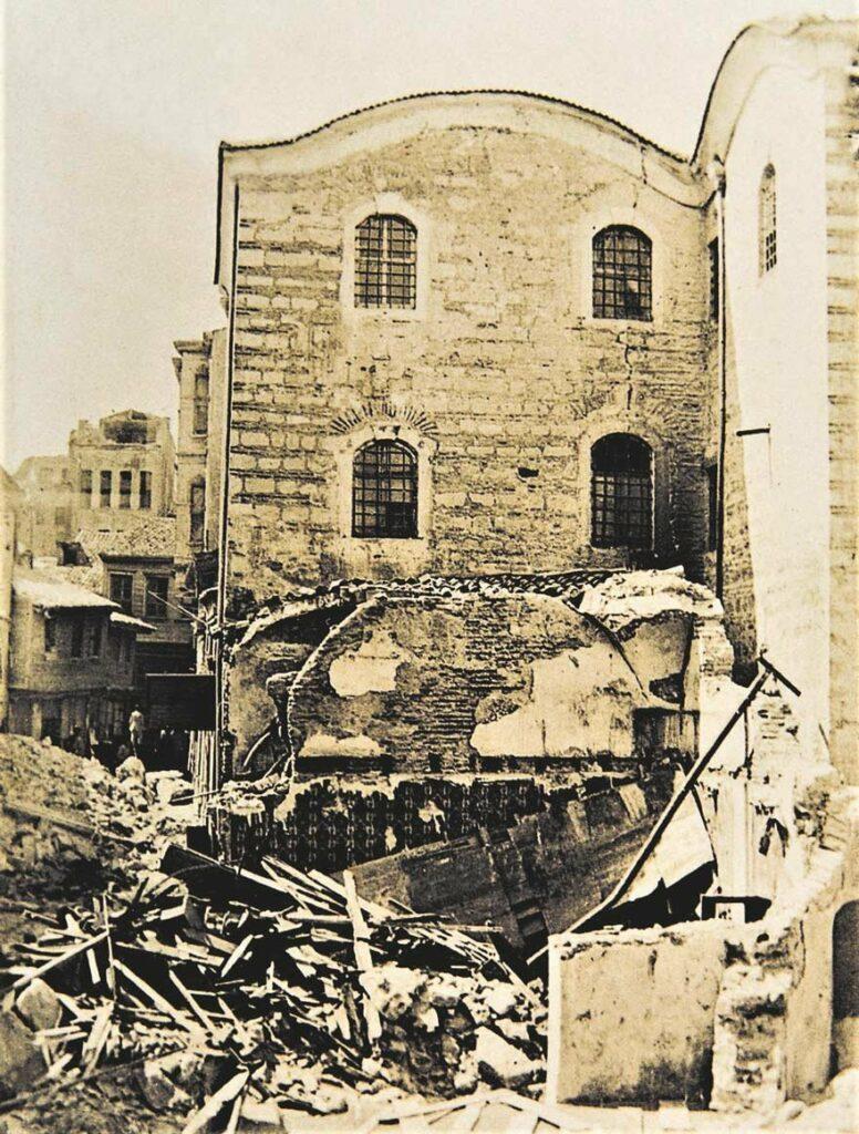
(Source, gdh.digital, 22 May 1766 earthquake)
Effects and Damage
Social and Economic Effects
Trade and the economy suffered greatly, forcing many tradespeople to close their shops. A large migration wave occurred after the earthquake, with migrants from rural areas contributing to the city’s reconstruction. The Ottoman State implemented measures such as tax amnesties to compensate for public losses.
Geological Context
The Marmara Sea is a pull-apart basin formed by the North Anatolian Fault Line. The 1766 earthquake resulted from the rupture of a segment of this fault beneath the Marmara Sea, causing widespread destruction in Istanbul and its vicinity.
The earthquake of 1894 is remembered as one of the most destructive to strike Istanbul during the Ottoman Empire. It holds a significant place in history due to both its physical destruction and its social and economic consequences.
Technical Characteristics of the Earthquake
Historical and Social Context
The 1894 earthquake, recorded during the Ottoman period, occurred under the reign of Sultan Abdülhamid II. Following the quake, at the Sultan’s instruction, construction of fire-resistant and more robust buildings began in Istanbul.
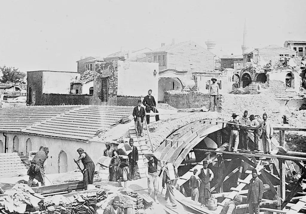
(Repair of arches in the Grand Bazaar after the 1894 earthquake, year 1896)
Effects and Damage
Social and Economic Effects
Markets and bazaars suffered major destruction, bringing commercial life to a standstill. The poor were the most affected group. Temporary shelter shortages and food scarcity emerged. The Ottoman State mobilized to assist victims and organized large-scale relief campaigns.
Geological Context
The Marmara Sea lies under the influence of the North Anatolian Fault Line, whose activity is the primary cause of earthquakes in the region. The 1894 Istanbul earthquake once again highlighted the city’s seismic risk and underscored the importance of constructing buildings capable of withstanding earthquakes.
The 1999 earthquake released a large portion of the accumulated energy along the Marmara segment of the North Anatolian Fault Line, but also increased the risk of a future major earthquake threatening Istanbul.
Technical Characteristics of the Earthquake
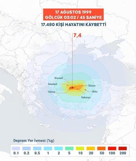
(Source, Anadolu Agency, 17 August 1999 earthquake)
Effects and Damage
Social and Economic Effects
A major humanitarian crisis followed the earthquake, with search and rescue operations lasting for days. National and international aid organizations provided support to meet the shelter, nutrition and health needs of earthquake victims.
Geological Context
The earthquake occurred along the North Anatolian Fault Line, which forms the boundary between the Eurasian and Anatolian plates and is a right-lateral strike-slip fault. The quake generated a surface rupture approximately 150 km in length.
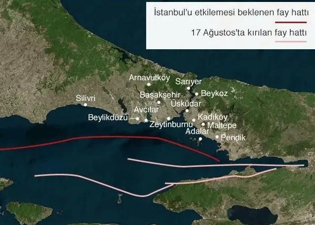
(Source, AFAD)
Istanbul, located along the northern branch of the North Anatolian Fault Line (NAF), is a metropolis with high seismic risk. Having experienced many major earthquakes throughout history, the city may face a new major quake in the coming years, as warned by scientists.
Istanbul has been shaken by major earthquakes throughout history and remains under a significant seismic threat today. Scientists emphasize that a major earthquake beneath the Marmara Sea is inevitable and that preparedness is essential. The city can minimize the impact of this disaster by taking necessary measures, but greater awareness and preparedness at both individual and institutional levels are required.
"1894 İstanbul Depremi - akademik tarih." Akademik Tarih, April 15, 2023
Anadolu Ajansı. "Anadolu Ajansı." Accessed. https://www.aa.com.tr/tr/info/infografik/40784.
BBC News Türkçe. "İstanbul’un deprem tarihi - BBC News Türkçe." March 5, 2023
Fikriyat Gazetesi. "İstanbul’un Bizans dönemi depremleri." February 26, 2023
Tarihten Yazılar. "Küçük kıyamet: 1509 İstanbul depremi." February 12, 2025
“İstanbul’s Great Nightmare: The May 22, 1766 Earthquake,” n.d. https://gdh.digital/haber/istanbulun-buyuk-kabusu-22-mayis-1766-depremi

No Discussion Added Yet
Start discussion for "Earthquakes in Istanbul in History" article
The 1509 Earthquake: Kıyamet-i Suğra
The 1766 Earthquake
The 1894 Istanbul Earthquake: “Büyük Hareket-i Arz”
The 1999 Kocaeli (Gölcük) Earthquake
Contemporary Perspective
Istanbul’s Seismic Risk Status
Recent Research and Fault Line Status
Istanbul’s Structural Resilience
Possible Earthquake Scenario and Expected Outcomes
Measures and Preparations Taken
Recommendations for Istanbul