This article was automatically translated from the original Turkish version.
+2 More
Feature(s) | One of the World's Widest and Tallest Waterfalls | ||||||||
|---|---|---|---|---|---|---|---|---|---|
Elevation(s)(Text) | Its deepest point is 108 meters | ||||||||
Width(Text) | Approximately 1708 meters | ||||||||
Location | On the Border of Zambia and Zimbabwe | ||||||||
Protection | UNESCO World Heritage Site | ||||||||
Altitude | Approximately 915 meters above sea level | ||||||||
Water Source | Zambezi River | ||||||||
Victoria Falls, a natural waterfall located on the Zambezi River at the border between Zambia and Zimbabwe. The waterfall is characterized by its wide water curtain, high spray plumes, daytime rainbows, and lunar rainbows formed under moonlight. These features visibly demonstrate the exceptional universal value of its natural beauty and geomorphological processes. The area encompasses a vast region including Mosi-oa-Tunya National Park, Victoria Falls National Park, and Zambezi National Park, and is classified as one of the seven natural wonders of Africa.
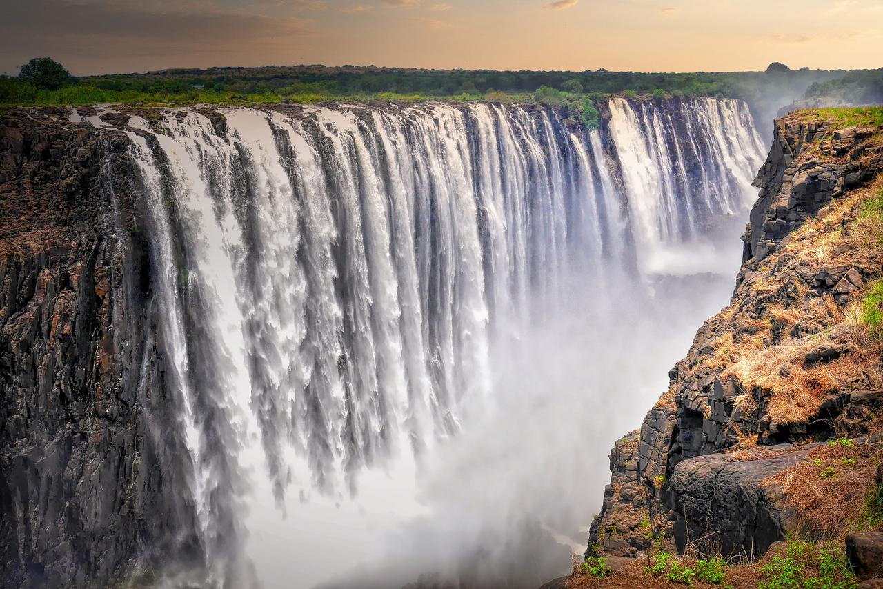
Victoria Falls (Pixabay)
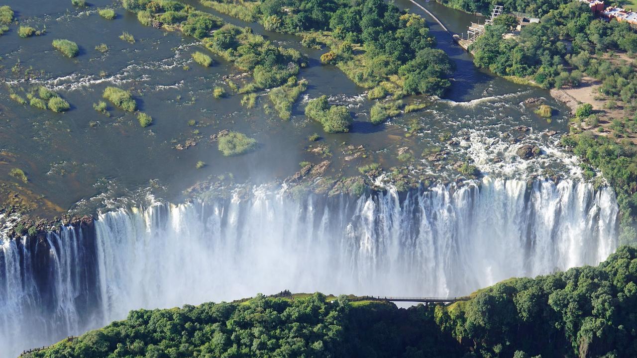
Victoria Falls is situated along the course of the Zambezi River, forming a natural boundary between southern Zambia and northwestern Zimbabwe. The waterfall is formed by the river’s water cascading over a steep drop in its channel, with the surrounding area bordered by the main river and its tributaries. The topography, riverbed, and hydrological connections of the region have a decisive influence on the local climate, water regime, and natural processes. The area around the falls is characterized by the moisture and water vapor generated by the river and the waterfall curtain. These environmental features shape local climatic conditions and enable the preservation of biological diversity.
The surrounding area functions as a natural conservation zone and contains diverse natural habitats. Its extent, including river islands and terrestrial parks, enhances ecosystem diversity. Mosi-oa-Tunya National Park, Victoria Falls National Park, and Zambezi National Park encompass both terrestrial and aquatic habitats, supporting a wide range of flora and fauna species. Additionally, the area’s environmental structure balances natural system preservation through tourist access points, observation trails, and boundary zones. These characteristics enable the waterfall to maintain both its natural integrity and the ecological functions of the region.
Victoria Falls is situated at an elevation of approximately 915 meters above sea level and features a broad water curtain shaped by the flow of the Zambezi River. The average depth of the falls is about 100 meters, with its deepest point reaching 108 meters and its total width extending to approximately 1,708 meters. This physical structure generates a constant spray of water and high humidity levels, directly influencing microclimatic conditions. The massive volume of water plunging from the height creates deep pools and fast-flowing currents at the base.【1】
Victoria Falls (Flickr)
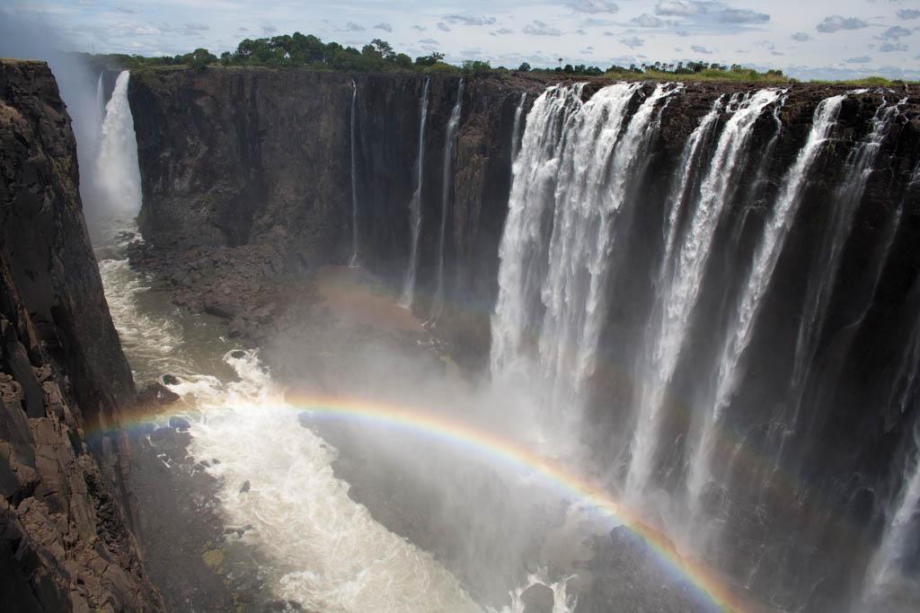
The spray rising from the falls determines environmental interactions and hydrographic distribution. These plumes are visible from approximately 30 kilometers along the Lusaka road on the Zambian side and 50 kilometers along the Bulawayo road on the Zimbabwean side, demonstrating that the waterfall has a visible impact beyond its immediate vicinity. The speed and intensity of the water flow shape the hydrological structure of the falls’ different channels and the distribution of islands. This interaction plays a critical role in determining the vegetation cover, soil moisture, and ecosystem structure of the region, enabling the observation of rainbows during daylight and under moonlight.【2】
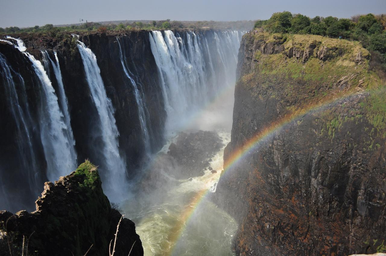
Victoria Falls formed primarily on basaltic rocks eroded by the flow of the Zambezi River. The region’s rock structure consists largely of volcanic basalt layers, which have enabled the waterfall to develop into multiple channels and gorges over time. Tectonic movements and erosion processes within the riverbed over millennia have been decisive in shaping the height and width of the falls. Cracks and fault lines in the basalt rock create natural barriers that redirect water flow and contribute to the distinct formation of the falls’ different channels.
Victoria Falls (Pixabay)
The geological structure of the falls also determines the distribution of surrounding plateaus and islands. Deep pools and rocky outcrops along the falls are shaped by continuous water flow and erosion. These processes lead to the formation of deeper depressions where hydraulic pressure intensifies at the base of the falls. Moreover, this geological structure directly influences soil composition, sediment distribution, and vegetation development in the surrounding area, thereby determining the diversity of the ecosystem and the microflow of water.
Victoria Falls is protected by both Zambia and Zimbabwe, as it lies within their respective borders, and the surrounding areas have been designated as national parks. Management policies regulate visitor flow to preserve the natural structure and ecosystem of the falls. These include designated walking paths and observation platforms to ensure both safety and conservation of the natural environment. Additionally, measures are implemented to prevent environmental degradation, including waste management, water quality monitoring, and protection of vegetation. Management authorities in the region collaborate with local communities to align tourism activities with principles of environmental sustainability, ensuring economic benefits while preserving natural habitats and biological diversity.
Tourism around Victoria Falls directly influences the economic and social structure of local communities. Tourism facilities at the falls and surrounding areas provide employment opportunities and enable communities to generate income through the sale of handicrafts and local products. Local administrations play a role in developing tourism infrastructure and services, supporting community participation in the sector. Simultaneously, communities contribute to the sustainability of tourism activities by offering guiding, accommodation, and food and beverage services. This relationship diversifies income sources for local residents and facilitates tourist access and experience; community involvement also helps balance the environmental and cultural impacts of tourism.
Victoria Falls (Flickr)
Victoria Falls plays a central role in the cultural life of local communities, beyond its natural value. The falls are regarded as a sacred site in traditional rituals and ceremonies and feature prominently in regional mythology and folk narratives. Its inscription on the UNESCO World Heritage List has ensured its international protection as both a cultural and natural heritage site.【3】 This status contributes to the sustainable preservation of regional culture and traditions, increases tourist interest in the area, and supports the spread of cultural awareness. Local communities participate in the management and conservation of cultural areas around the falls, gaining both economic and cultural benefits, thereby reinforcing the cultural and social importance of the waterfall.
Abi.bhattachan. “Victoria Falls, Matabeleland North, Zimbabwe.” Flickr. Accessed March 25, 2026. https://www.flickr.com/photos/abibhattachan/4954753869/
BabijaPhoto JB. “An aerial view of the victoria falls in zimbabwe.” Pexels. Accessed March 25, 2026. https://www.pexels.com/photo/an-aerial-view-of-the-victoria-falls-in-zimbabwe-27878405/
Bierlein, Jürgen. “Victoria şelalesi, Afrika, Zimbabve görseli.” Pixabay. Accessed March 25, 2026. https://pixabay.com/tr/photos/victoria-%c5%9felalesi-afrika-zimbabve-4885483/
Fietzfotos. "Victoria Falls, Waterfalls, Cliff Image." Pixabay. Accessed March 25, 2026. https://pixabay.com/tr/photos/victoria-%c5%9felalesi-%c5%9felaleler-u%c3%a7urum-5903496/
Haynes, Charles. “Victoria Falls.” Flickr. Accessed March 25, 2026. https://www.flickr.com/photos/haynes/8376758661/
Masimba, Julianos. “Assessing the Role of Local Authorities in Promoting Tourism in Zimbabwe: A Case of Victoria Falls City Council.” *Journal of the Kenya National Commission for UNESCO* 4, no. 2 (2024): 1–14. Accessed March 25, 2026. https://journals.unesco.go.ke/index.php/jknatcom/article/view/121
Ninara. “Victoria Falls, Zimbabwe.” Flickr. Accessed March 25, 2026. https://www.flickr.com/photos/ninara/14534832134/
UNESCO World Heritage Centre. “Mosi-oa-Tunya / Victoria Falls.” State of Conservation. Accessed March 25, 2026. https://whc.unesco.org/en/soc/4639
UNESCO. “Mosi-oa-Tunya / Victoria Falls.” World Heritage List. Accessed March 25, 2026. https://whc.unesco.org/en/list/509
Zulu, John. “Management and Conservation of the Mosi-oa-Tunya/Victoria Falls World Heritage Property.” In *Managing Transnational UNESCO World Heritage Sites in Africa.* (2023): 37-45. Accessed March 25, 2026. https://link.springer.com/chapter/10.1007/978-3-030-80910-2_4?
[1]
UNESCO, “Mosi-oa-Tunya / Victoria Falls,” World Heritage List, Last Access: 25 March 2026, https://whc.unesco.org/en/list/509
[2]
UNESCO, “Mosi-oa-Tunya / Victoria Falls,” World Heritage List, Last Access: 25 March 2026, https://whc.unesco.org/en/list/509
[3]
UNESCO, “Mosi-oa-Tunya / Victoria Falls,” World Heritage List, Last Access: 25 March 2026, https://whc.unesco.org/en/list/509
Feature(s) | One of the World's Widest and Tallest Waterfalls | ||||||||
|---|---|---|---|---|---|---|---|---|---|
Elevation(s)(Text) | Its deepest point is 108 meters | ||||||||
Width(Text) | Approximately 1708 meters | ||||||||
Location | On the Border of Zambia and Zimbabwe | ||||||||
Protection | UNESCO World Heritage Site | ||||||||
Altitude | Approximately 915 meters above sea level | ||||||||
Water Source | Zambezi River | ||||||||
Location and Environmental Features
Physical Structure and Hydrography
Geological Formation
Conservation Status and Management
Tourism and Local Community Relations
Cultural Significance
