


This article was automatically translated from the original Turkish version.
HAVELSAN Kaşif
Producing | HAVELSAN | ||||||||
|---|---|---|---|---|---|---|---|---|---|
National Origin | Türkiye | ||||||||
Variant | KAŞİF-J, KAŞİF-W, KAŞİF-S | ||||||||
Type | Geographic Information System (GIS) Command and Control Platform | ||||||||
KASHIF is a modular Geographic Information System (GIS) solution developed by HAVELSAN. It consists of three main modules: separate client libraries for desktop and web applications (KASHIF-J and KASHIF-W) and a server component (KASHIF-S). Its purpose is to provide situational awareness by collecting processing and visualizing real-time and historical geospatial data for land sea and air operations.
HAVELSAN KASHIF (HAVELSAN)
The foundations of KASHIF were laid in the late 1990s through GIS infrastructure projects initiated by HAVELSAN to meet military simulation and command-and-control requirements. Initially developed as a Java-based desktop client library KASHIF-J was later enhanced with real-time mobile platform tracking and symbology support. Between 2005 and 2010 as demand for mobile and web-based applications grew the KASHIF-W project was launched introducing WebGL-enabled 2D/3D map visualization capabilities. Concurrently the KASHIF-S module was developed using Open Geospatial Consortium (OGC) standards to enable military and civilian organizations to share geospatial data on a common platform. Field testing and integration efforts conducted between 2012 and 2015 led to the modular architecture currently in use.
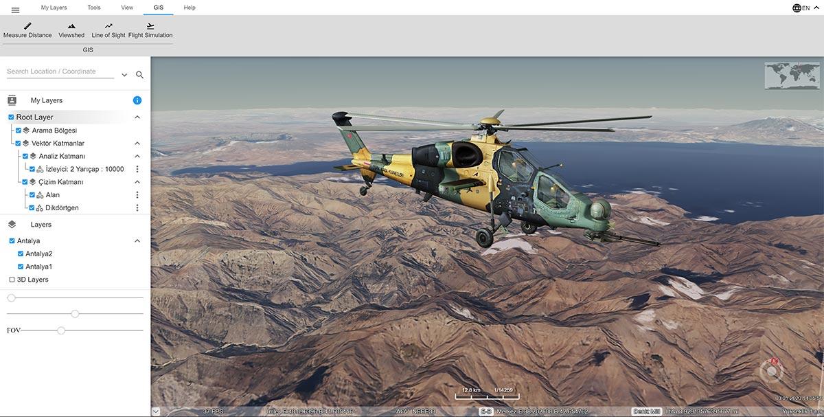
KASHIF-J is a desktop-based GIS client running on the Java Virtual Machine (JVM). Leveraging an OpenGL-based rendering engine it delivers both 2D map layers and 3D terrain models in real time. It supports symbols compliant with international military symbology standards including NATO APP-6A/6B/6D MIL-STD-2525C and TAF MS-76-2. It can retrieve raster and vector data layers from servers via WMS WFS WCS and WMTS protocols. It delivers high performance through parallel data processing on multi-core processors and includes security features such as role-based access control (RBAC) and end-to-end encryption (HTTPS/TLS).
KAŞİF-J ()
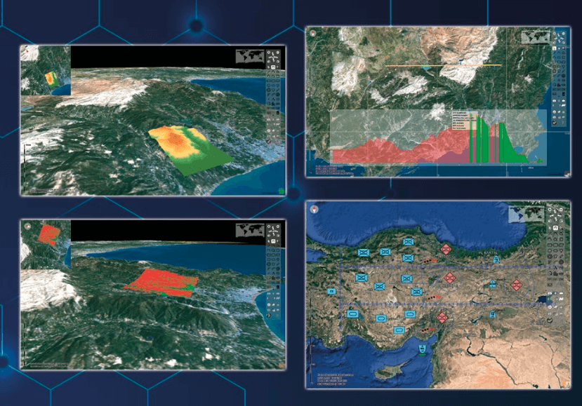
KASHIF-W is a JavaScript/TypeScript-based client that operates in modern web browsers. WebGL-enabled 2D/3D terrain modeling and map layers enable users to access integrated geospatial data directly through their browsers. With a time slider for time-series data it can play back historical or real-time sensor data. It includes symbology management and fundamental geospatial analysis tools such as area distance and buffer zone calculations. Compatibility with CMAPI 1.3.0 enables standards-based integration with external command-and-control systems. It supports RESTful and WebSocket-based data streaming to the server.
KAŞİF-W ()
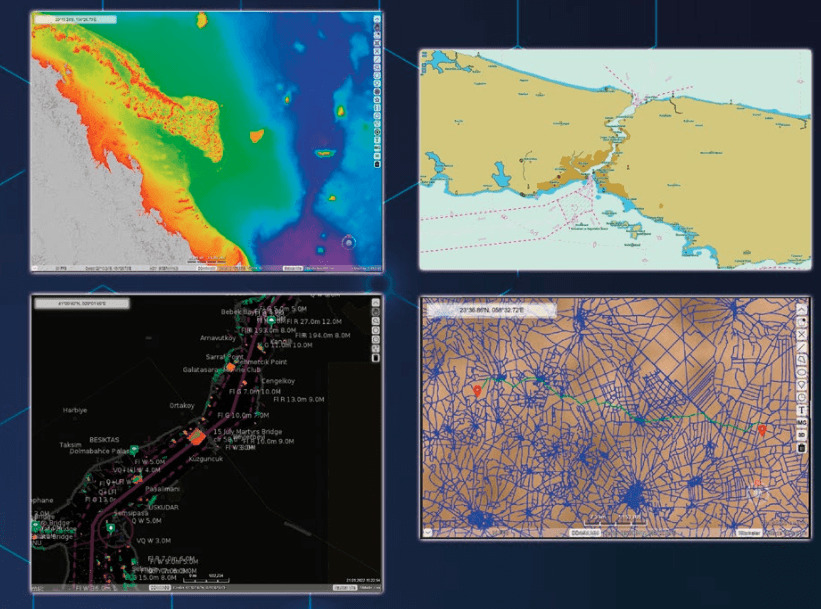
KASHIF-S is a scalable server infrastructure that delivers OGC-compliant map and data services (WMS WFS WCS WMTS). It ingests data from raster formats such as GeoTIFF ECW and MrSID and vector formats such as ESRI Shapefile GeoJSON KML and PostGIS and dynamically distributes them to clients. Integration of electronic navigational charts (ENC) in S57/S63/AML formats enables support for maritime applications. It can convert meteorological data formats such as NETCDF GRIB and Metar into georeferenced layers. The geospatial analysis engine performs complex computations such as viewshed and network analysis on the server side. Through a cluster architecture it ensures high availability and load balancing enabling real-time processing of large datasets.
KAŞİF-S ()
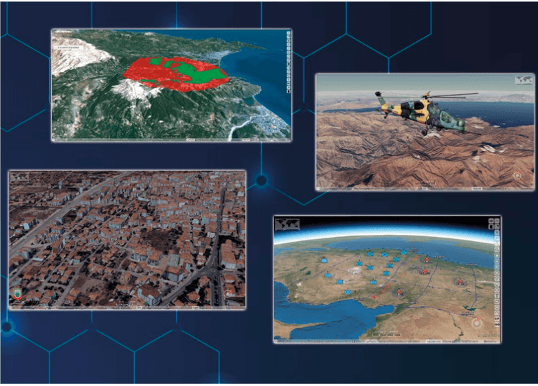
KASHIF supports multi-layered 2D/3D map presentation. Satellite imagery topographic maps infrastructure layers and digital elevation models (DEM) can be dynamically rendered on the client side after being uploaded to the server. Users can adjust the display hierarchy of map layers and toggle symbol sets to control information density. Three-dimensional terrain models serve as the foundation for viewshed analysis elevation profiling and shadow calculations.
Electronic navigational charts in S57/S63/AML format are critical for maritime platform navigation and operational planning. KASHIF-S processes these ENC files to enhance maritime route safety. Information such as underwater topography water depth and hazard zones is displayed as layered map elements. ENC updates are processed periodically on the server ensuring the navigational safety of submarines and surface vessels.
KASHIF-S converts meteorological data in GRIB and NETCDF formats into georeferenced layers. Wind speed and direction pressure temperature precipitation wave height and ocean current data are presented as dynamic map layers. These layers support risk analysis for maritime and air operations enabling route adjustments based on meteorological conditions during vessel and flight planning.
GPS data from land units is transmitted in real time to tactical command centers. Unit movements supply lines and operational plans are displayed on the map to provide decision-makers with immediate situational feedback. Detection points from electronic warfare systems are visualized as symbols on KASHIF-J enabling early identification of potential threats. Tactical planning modules offer route optimization and logistics support solutions for both command staff and field teams.
KASHIF-W is deployed on command-and-control centers aboard warships frigates and submarines. S57/S63-based ENC charts meet the precise positioning and route safety requirements of submarines. In 2016 the HAVELSAN KASHIF GIS solution was integrated into the Agosta 90B submarine modernization project for the Pakistan Navy. This integration enhanced operational safety by enabling combined processing of submarine navigation underwater hazard maps and sonar data on a unified map interface.
KASHIF-W supports flight planning by integrating air space data altitude layers and meteorological layers. Radar surveillance points and potential threat scenarios are dynamically updated on command-and-control center maps. In UAV missions a beyond-line-of-sight satellite communication (SATCOM) link enables long-range imagery intelligence (ISR) operations.
In disaster scenarios such as earthquakes floods and fires KASHIF analyzes critical infrastructure points population density maps and logistics distribution routes. Evacuation planning modules identify optimal routes reducing response times for civil defense units. In urban planning geospatial analyses support infrastructure projects and green space management promoting sustainable urban development goals.
In 2016 as part of the Pakistan Navy’s modernization program for its Agosta 90B-class submarines HAVELSAN integrated the KASHIF-S and KASHIF-J modules. Key outcomes of this project include:
In projects for the Royal Saudi Armed Forces the KASHIF-S server and KASHIF-W client have been used to establish shared map platforms for multinational exercises. Integration of meteorological data under extreme climate conditions has provided advantages in planning UAV/UGV missions in desert regions. In collaborations across Central Asia and North Africa client modules optimized for low-bandwidth environments have been preferred.
KASHIF features a modular licensing structure. User organizations can license KASHIF-J KASHIF-W or KASHIF-S components individually or as bundled packages. Concurrent user count analysis modules and additional symbology packages are defined according to licensing agreements. Annual maintenance contracts provide software updates bug fixes and technical support services.
Training programs delivered through the HAVELSAN Academy include introductory and advanced courses for KASHIF-J and KASHIF-W users. Foundational courses cover map layer creation symbology management and use of basic analysis tools. Advanced modules address server infrastructure setup performance optimization and data security. Project-based training includes instruction on custom modules developed for field integration scenarios.
HAVELSAN. "1729094518_kasif-brosur." HAVELSAN. Accessed March 16, 2025.https://www.havelsan.com/uploads/docs/urunler/komuta-kontrol-savunma/1729094518_kasif-brosur.pdf
HAVELSAN. "HAVELSAN Kaşif." YouTube. Accessed March 16, 2025.https://youtu.be/TBTOsH_4sf4?si=zJ2u30y7RZUbbncl
HAVELSAN. "KAŞİF." HAVELSAN. Accessed March 16, 2025.https://www.havelsan.com/tr/urunler/kasif
Khalid, Zaki. "Pak-Turk Naval Partnership in Western Indian Ocean." Centre for Strategic and Contemporary Research. Accessed March 16, 2025.https://cscr.pk/explore/themes/defense-security/pak-turk-naval-partnership-in-western-indian-ocean/
HAVELSAN Kaşif
Producing | HAVELSAN | ||||||||
|---|---|---|---|---|---|---|---|---|---|
National Origin | Türkiye | ||||||||
Variant | KAŞİF-J, KAŞİF-W, KAŞİF-S | ||||||||
Type | Geographic Information System (GIS) Command and Control Platform | ||||||||
History and Development Process
Architecture and Components
KASHIF-J (Java Client Library)
KASHIF-W (Web-Based Client Library)
KASHIF-S (Server Component)
Technical Features and Standards
OGC-Compliant Data Services
Military Symbology Standards
Data Formats and Integration
Security and Access Control
Performance and Scalability
Functionality and Modules
Map Visualization and Modeling
Geospatial Analysis Tools
Electronic Navigational Charts (ENC)
Meteorological and Oceanographic Data
Applications
Land Forces and Tactical Command Centers
Naval Forces and Submarine Platforms
Air Forces and Unmanned Aerial Vehicles (UAVs)
Civil Disaster Management and Urban Planning
International Collaborations and Example Projects
Pakistan—Agosta 90B Submarine Modernization
Saudi Arabia and Other Partnerships
Licensing Training and Support
Licensing Model
Training and Certification