This article was automatically translated from the original Turkish version.
License Plate Code(Text) | 52 | ||||||||
|---|---|---|---|---|---|---|---|---|---|
Area(s)(Text) | 112 square kilometers | ||||||||
Population(Text) | 8,300 (2019) | ||||||||
Means of Livelihood | Fishing Hazelnut cultivation | ||||||||
Former Name | Ebulhayr Abulhayr | ||||||||
Geographical Region | Black Sea Region | ||||||||
所属省份 | Ordu | ||||||||
Gülyalı is a district of Ordu province in Türkiye, located on the Black Sea coast. The district exhibits the typical geographical features of the Black Sea Region and covers an area of 112 square kilometers. While its distance from the Ordu provincial center toward Giresun is reported in institutional sources as 8 km, 12 km, and 16 km respectively, its distance from Giresun is stated as 32 km.【1】 In recent years, tourism, kiwi cultivation, and livestock farming have been integrated into the local economy, which has traditionally relied primarily on hazelnut cultivation and fishing.
The historical geography of the Gülyalı region is integrated into the broader history of Central and Eastern Black Sea. It is noted that the area hosted various colonies since antiquity, with settlement patterns along the coastline resembling fortress-harbors.【2】 Although there was no dense settlement in the region until the 14th century, beginning in the second half of the 13th century, Turkmen and Çepni tribes, under the organization of the Hacıemiroğulları Beylik, Turkified the region and established new settlement areas. During the Ottoman period, this administrative unit continued to exist and was referred to in sources by names such as "Ebulhayr," "Abulhayr," or "Abulhayır."【3】
With the advent of the Republic, population growth and the expansion of settlements necessitated the establishment of a municipal administration. In 1971, an application to establish a municipality under the name "Abulhayır" was rejected due to its Arabic origin. Subsequently, the name was changed to "Gülyalı," combining the word "gül" (rose) with "yalı" (meaning shoreline). As a result of this new application, Gülyalı Municipality was established on February 29, 1972, by Decree No. 10645, merging the villages of Alibey and Eski Sayaca. Gülyalı attained district status on June 19, 1987, under Law No. 3392, and its first district governor was appointed on August 1, 1988.
Gülyalı (Gülyalı Belediyesi)
The topography of Gülyalı consists of a narrow coastal strip immediately followed by rugged, ascending terrain. Mountains of modest elevation run parallel to the sea, with the district’s most prominent peaks being Gökhasan, Taaruz, and Tüylak. Within the triangular-shaped territory extending inland, important rivers include Turnasuyu, Değirmendere, Hoşköy, Fasılcık, Divani, and Abdal Deresi, which forms the boundary with the district of Piraziz.
The district exhibits typical Black Sea climate characteristics, with a moderate transition between maritime and continental influences along the shoreline. Annual average rainfall is reported at 100 mm and relative humidity at 76%.【4】 The average temperature in the coldest month, February, is 6–7°C, while in the warmest months, July and August, it reaches 23–24°C. Winds generally blow from the west and southwest; during summer days, cool breezes known locally as "poyraz" blow from the northeast, moving from sea to land.
According to the Address-Based Population Registration System, the district’s population was 7,980 in 2011 and increased to 8,300 by 2019. A significant portion of the population resides in neighborhoods, with Turnasuyu Neighborhood being the most populous settlement, recording a population of 2,249 according to 2011 data.【5】
Following Ordu province’s acquisition of metropolitan status in 2013, village legal entities were abolished and all areas were incorporated into the municipal service area. Gülyalı now consists of a total of 13 neighborhoods.【6】 These neighborhoods are Alibey, Ambarcılı, Ayrılık, Gülistan, Hoşköy, Kestane, Mustafalı, Sayaca, Taşlıçay, Tepealtı, Turnasuyu, Ürümbey, and Yeniköy.

Medet Sipahi (Gülyalı Belediyesi)
The founding mayor of Gülyalı Municipality was Yakup Sakaoğlu, who served from 1972 to 1973. Throughout its history, this position has been held by various individuals; in the 2019 local elections, Ulaş Tepe was elected and earned the title of "Türkiye’s youngest mayor." According to the most recent administrative information, the current mayor is Medet Sipahi, who has served for many years as a neighborhood muhtar in the district.【7】 The district’s first district governor was Mehmet Aydın; later, Muhammed Enes İpek and, as of 2020, Burhanettin Yavaşi served in this role.
The district’s economy is primarily based on agriculture and livestock farming; the livelihood of the population relies mainly on hazelnut cultivation and fishing. In addition to traditional agriculture, kiwi cultivation, dairy farming, and beef production are also practiced in the district.
Significant investments have been made in transportation infrastructure to support economic and commercial development, with the most important being the Ordu-Giresun Airport. This facility, the first airport in Türkiye built over the sea and the third such airport in the world, was constructed with the aim of enhancing the district’s tourism and trade potential, and was scheduled to begin operations in 2014.【8】
Turnasuyu Valley (Kültür Portalı)
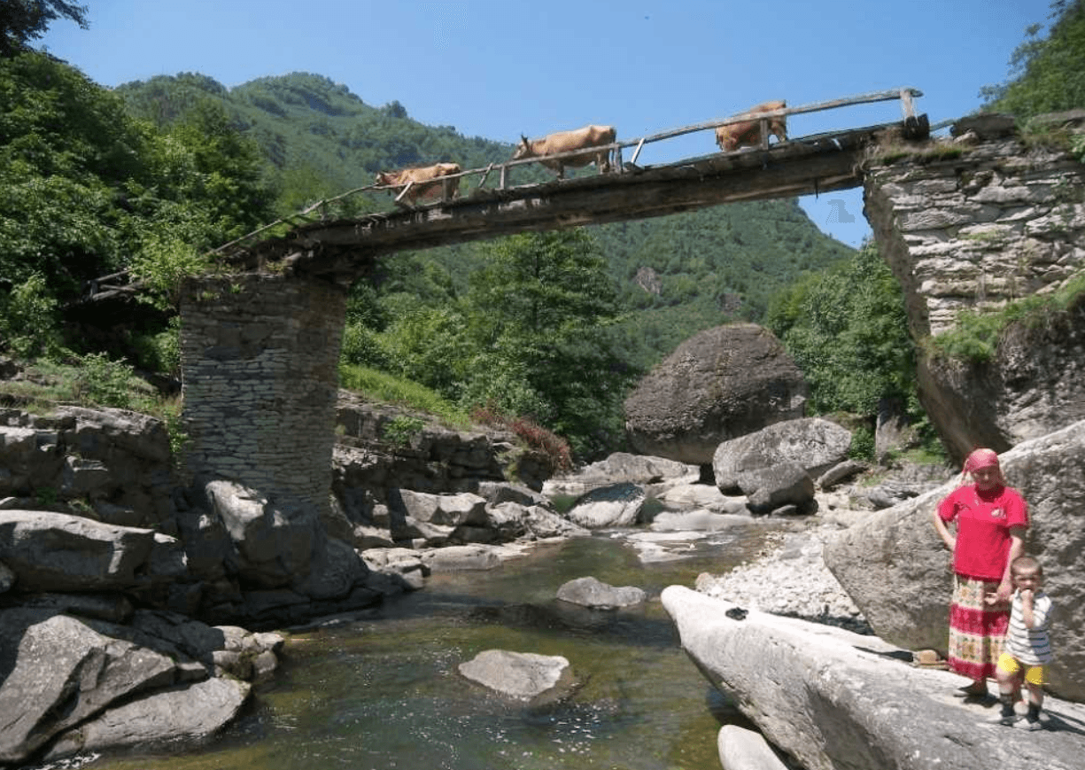
With its natural beaches, sea, and green landscape, Gülyalı is among the settlements in Ordu province with Blue Flag beaches. The main coastal tourism areas offering year-round services include Mavi Dünya Plaj Restaurant and Çadır Kampı, as well as the Authentic Public Beach, both located in the Tepealtı locality, along with their social facilities and recreational areas. Additionally, under nature tourism, Turnasuyu Life Valley, Çağlayan Waterfall, and Sayaca Gelincik Rock are among the natural attractions in the district.

Turnasuyu Valley (Kültür Portalı)
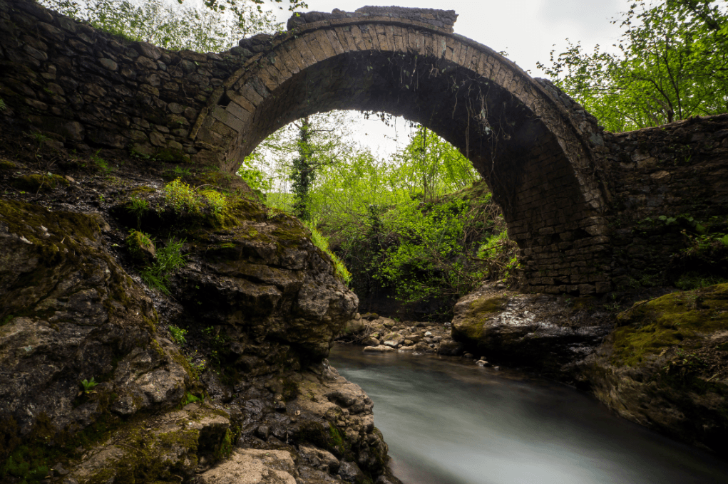
The region also hosts cultural heritage sites featuring examples of stone architecture. Registered heritage sites include the Dayınlı and Değirmenyanı bridges in Kestane village (neighborhood) and the bridge at Hasanlı locality. Similarly, the Central Mosque and historic fountain in the same neighborhood, the fountain in Ayrılık village, and the protected monumental oak tree in Turnasuyu village represent the district’s registered civil and religious architectural richness.
Accessed November 26, 2025. https://www.aa.com.tr/tr/kultur/ahlatta-acilan-kurslarla-geleneksel-tas-isciligi-yasatiliyor/3116279.
Baş, Mithat and Şinasi Tepe. Gülyalı İlçesi Tarihi: Ebulhayr Kethüda. Ordu: Gülyalı Belediyesi Yayınları, 2013. Accessed April 20, 2026.
Gülyalı Belediyesi. "Başkanın Özgeçmişi." Accessed April 20, 2026. https://www.gulyali.bel.tr/sayfa/baskanin-ozgecmisi.html
Gülyalı Belediyesi. "Gezilecek Yerler." Accessed April 20, 2026. https://www.gulyali.bel.tr/sayfa/gezilecek-yerler.html
Gülyalı Belediyesi. "Mahalleler." Accessed April 20, 2026. https://www.gulyali.bel.tr/sayfa/mahalleler.html
Gülyalı Belediyesi. "Muhtarlarımız." Accessed April 20, 2026. https://www.gulyali.bel.tr/sayfa/muhtarlarimiz.html
Gülyalı Belediyesi. "Tarihçemiz." Accessed April 20, 2026. https://www.gulyali.bel.tr/sayfa/tarihcemiz.html
T.C. Ministry of National Education OrduGülyalı İlçe National Education Directorate. "Tarihçe." Accessed April 20, 2026. https://gulyali.meb.gov.tr/www/tarihce/icerik/919
T.C. Ordu Valiliği. "Gülyalı." Accessed April 20, 2026. https://www.ordu.gov.tr/gulyali
T.C.Gülyalı Kaymakamlığı Governorship. "Tarihçe." Accessed April 20, 2026. https://www.gulyali.gov.tr/tarihce
Türkiye Kültür Portalı. "Turnasuyu Vadisi Yürüyüş Parkuru." Accessed April 20, 2026. https://www.kulturportali.gov.tr/turkiye/ordu/gezilecekyer/turnasuyu-vadisi-yuruyus-parkuru
[1]
[2]
[3]
[4]
[5]
[6]
[7]
[8]
License Plate Code(Text) | 52 | ||||||||
|---|---|---|---|---|---|---|---|---|---|
Area(s)(Text) | 112 square kilometers | ||||||||
Population(Text) | 8,300 (2019) | ||||||||
Means of Livelihood | Fishing Hazelnut cultivation | ||||||||
Former Name | Ebulhayr Abulhayr | ||||||||
Geographical Region | Black Sea Region | ||||||||
所属省份 | Ordu | ||||||||
History
Geography and Climate
Population and Administrative Structure
Local Government
Economy and Transportation
Tourism and Cultural Heritage
