


This article was automatically translated from the original Turkish version.
+2 More
Serissa Ancient City
Location | Türkiye Altınyayla District Sivas Başören Village | ||||||||
|---|---|---|---|---|---|---|---|---|---|
Coordinates | Approximately 60 km southwest of the Sivas provincial center | ||||||||
Founding Period | 16th century BC (Old Hittite Period) | ||||||||
Elevation | A natural hill at an elevation of approximately 1650 meters | ||||||||
Urban Plan | Oval plan measuring 235 x 237 meters; area of 18 hectares | ||||||||
Defensive Structure | Walls 1.5 km long built using ashlar masonry technique; four city gates | ||||||||
Excavation Start | 1992 (surface surveys), 1993 (systematic excavations) | ||||||||
Excavation Director | Prof. Dr. Andreas Müller-Karpe (University of Marburg, Germany) | ||||||||
Excavating Institution | Sivas Museum Directorate | ||||||||
Prominent Structure | Temple I Structures A and B Structure C (Temple of the Storm God) | ||||||||
Written Documents | 52 cuneiform tablets, seal impressions, oracular and ritual texts | ||||||||
Water Structures | Three dam structures in the northwest, southwest and southeast (among the oldest examples) | ||||||||
Agricultural Remains | Wheat, Barley, Lentil, Flax, Pea, Vetch | ||||||||
Museum Artifacts | Double Bull Rhyton statue (in the Sivas Archaeology Museum) | ||||||||
Important Feature | Sacred city that hosted Hittite religious rituals | ||||||||
International Significance | City where an oath was taken to the Storm God in the Treaty of Kadesh | ||||||||
Current Name | Kuşaklı | ||||||||
One of the settlements shedding light on the prehistoric and early historical periods of Anatolia is the Ancient City of Sarissa, known as one of the cities of the Hittite Empire. Located today in the Kuşaklı region, four kilometers east of Başören Village in the Altınyayla district of Sivas Province, this settlement occupies a strategic position on a natural hill. The city, believed to have been founded in the 16th century BCE, holds a unique position within the Hittite settlement network in terms of both its architectural scale and its religious and political functions. The name Šarišša, recorded in Hittite written sources, has been confirmed by seals and tablets unearthed during excavations. The temples, cuneiform archives, defensive systems, and examples of hydraulic engineering uncovered through archaeological work demonstrate that the city functioned as a multifaceted administrative, religious, and cultural center. In this context, Sarissa constitutes a significant archaeological site for understanding the provincial urban structure of Hittite civilization.
Hittite Dam (T.C. Altınyayla District Governorship)
Known in antiquity as Šarišša, this settlement, today referred to as Kuşaklı, is situated approximately 60 kilometers southwest of the center of Sivas Province and four kilometers east of Başören Village in Altınyayla District, near the Ak Kuzulu hamlet. The city was built on a hill with an average elevation of 1,650 meters, located south of the Maraššantiya River (Kızılırmak). This natural hill features a plateau character surrounded by mountains extending approximately 2,000 meters in circumference. In Hittite texts, the region is designated as the “Upper Land” and lies approximately 500 meters higher than the capital Hattusa. The area is characterized by a harsh continental climate, with hot and dry summers and very cold winters accompanied by frost events.

Aerial View of the City (AA)
Sarissa has an oval layout measuring approximately 235 by 237 meters. The city is encircled by a defensive wall system approximately 1.5 kilometers in length, constructed using the box-wall technique. This wall system consists of two parallel walls, reinforced by towers every 25 meters. The foundations of the walls are made of limestone, while the upper sections are built with wooden frameworks filled with sun-dried brick. Four main gates have been identified in the city; the northwestern and southeastern gates have been excavated.
Šarišša was founded in the 16th century BCE during the Old Hittite Period. Evidence indicates that the city was destroyed around the beginning of the 14th century BCE by siege and fire, subsequently rebuilt, and continued to be used throughout the Hittite Empire period. It suffered a second destruction in the 12th century BCE due to a catastrophic fire and was abandoned following the collapse of the Hittite state. During the Late Hittite Period, some abandoned structures were reused, but this occupation was short-lived. Additionally, a fortress was constructed on the Hittite acropolis during the 7th–6th centuries BCE.
Archaeological research at Sarissa began in 1992 with surface surveys, and excavation work commenced in 1993 under the direction of Professor Dr. Andreas Müller-Karpe from the University of Marburg, Germany. These excavations continue to be conducted on behalf of the Sivas Museum Directorate. The team includes geophysicist H. Stümpel, tablet specialist G. Wilhelm, specialist on Structure E S. Arnhold, dam structure specialist A. Hüser, ceramic specialist D.P. Mielke, and researcher of the southeastern gate A. Schachner.

Images from Archaeological Excavations (Sivas Provincial Directorate of Culture and Tourism)
The identification of the settlement as Sarissa was confirmed through the decipherment of a hieroglyphic inscription on a ceramic fragment and the discovery of seal impressions bearing the phrase “King of Šarišša.” The city is mentioned numerous times in Hittite cuneiform texts. Of the 52 tablets recovered during excavations, many contain information on religious rituals, oracular texts, and festival celebrations. Some texts refer to festivals held at Mount Kupit. Seals found at the site indicate that the name of the king was either “Mazitima” or “Mimazati.”
Sarissa was an important center in Hittite religious life. In particular, Structure C (the Temple of the Storm God) and Temple I on the northern terrace reflect the sacred identity of the city. Written documents found in the temple structures indicate that kings regularly traveled here in spring to conduct ceremonial activities and performed rituals before the Huwaşi Stone. The fact that the Storm God of Sarissa was invoked in the Treaty of Kadesh demonstrates the city’s international religious significance.
Structures A and B, located south of the acropolis, were excavated between 1994 and 1996. Although religious tablets found in Structure A suggest a cultic function, its architectural features indicate it was likely not a temple but rather a priest’s residence. Structure B is a typical example of Old Anatolian domestic architecture, consisting of a narrow entrance leading to a central hall with side rooms.
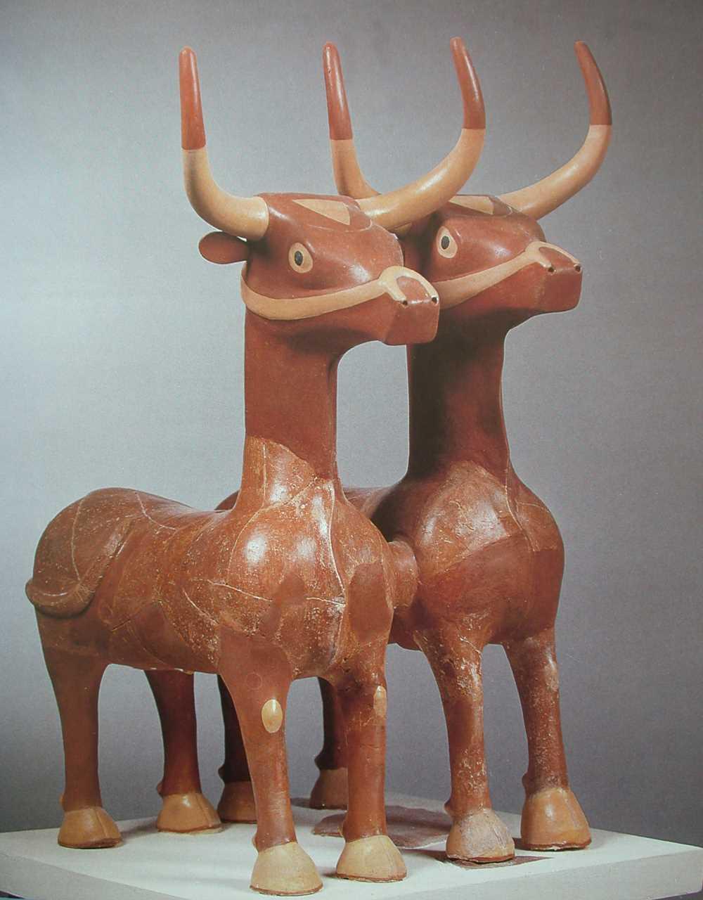
Structure C, covering an area of 4,660 square meters, is the largest Hittite temple discovered to date. It features two monumental entrances, one in the northeast and the other in the southwest. Access to the cult chamber, measuring 210 square meters, is gained through an inner courtyard. Beneath the main floor, two cult rooms supported by 16 columns are located. The southeast façade of the building, which appears to have been at least two stories high, supports this interpretation. A twin bull statue found in the basement represents the sacred animals of the Storm God.
Temple I, located on the northern terrace, shares a similar plan with Structure C. Fifty-one rooms have been identified in its basement level.
In one of the southern rooms of Structure C, an archive room contained approximately 50 cuneiform tablets, mostly concerning divination (bird and liver omens), inventories, offerings lists, and food records. Tablets found in Structure D detail royal rituals and religious practices. These texts have been chronologically dated to the 13th century BCE.

Tablet Recovered from Archaeological Excavation (Sivas Provincial Directorate of Culture and Tourism)
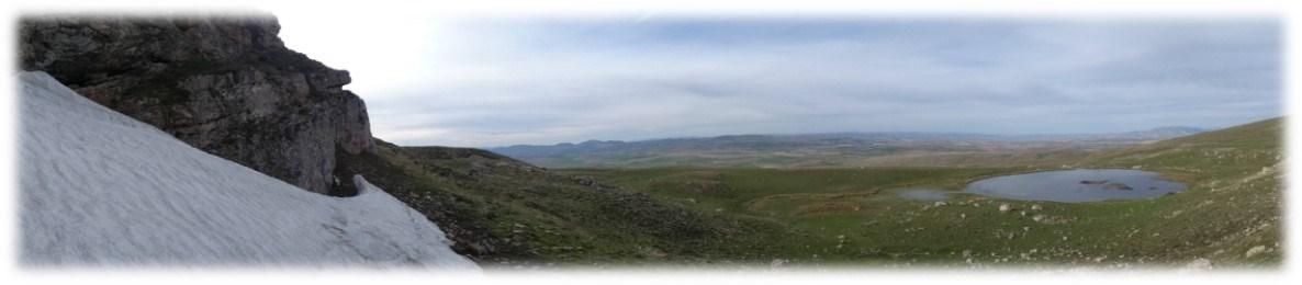
Three reservoir structures located in the southwestern, southeastern, and northwestern parts of the city date to the late 16th century BCE. The northwestern reservoir measures 60 by 10 meters and has a capacity of 4,300 cubic meters; the southwestern reservoir is 10 meters wide with a capacity of 1,500 cubic meters; and the southeastern reservoir is 40 meters wide with a capacity of 7,500 cubic meters. These dam structures represent some of the earliest examples of engineering in Anatolia from the Hittite period. Open-air cultic areas and architectural traces indicating the presence of the Huwaşi Stone have also been identified on the western side of the reservoir.
Two types of storage systems have been identified at Sarissa: above-ground vessels for daily use and large-scale underground silos. In room 58 of Structure C, carbonized and partially germinated barley grains were recovered, suggesting the room may have been used for beer production. In Structure D, located south of the acropolis and measuring 50 by 30 meters, a large silo with a capacity of 1,200 cubic meters was uncovered. Analyses revealed remains of five types of wheat (einkorn, emmer, sanduri, bread wheat, and spelt), along with foxtail millet, lentils, vetch, bitter vetch, peas, and flax.
According to the Sivas Provincial Directorate, efforts have been initiated to develop Sarissa for tourism. Governor Salih Ayhan visited the site, received information from the excavation team, and emphasized the need to preserve and promote the historical value of Sarissa and Samuha. Artifacts recovered from the excavations are exhibited at the Sivas Archaeology Museum, with some examples displayed at the Museum of Anatolian Civilizations in Ankara.
The Ancient City of Sarissa presents a significant example of Hittite urbanization, religious rituals, economic activities, and engineering practices through its architecture, written documents, and archaeological finds. The temple structures, particularly Structure C, known as the Temple of the Storm God, attract attention not only for their size but also for their sacred function. Moreover, the cuneiform tablets unearthed at the site confirm that Sarissa was not merely a settlement but also one of the key cult centers of the Hittite Empire. The water systems, storage facilities, and defensive architecture reflect the Hittites’ technical expertise and foresight in urban planning. To date, excavations have clearly established Sarissa’s historical identity and its place in Anatolian archaeology. Based on the data obtained, it is evident that this settlement held a distinctive position among Hittite provincial cities.
Altınyayla Kaymakamlığı. "Sarissa Antik Kenti." Accessed May 13, 2025.http://www.altinyayla.gov.tr/sarissa-antik-kenti
Anadolu Ajansı. “Sarissa Antik Kenti Turizme Kazandırılacak.” Accessed May 13, 2025.https://www.aa.com.tr/tr/kultur-sanat/sarissa-antik-kenti-turizme-kazandirilacak-/1602299
Ministry of Culture and Tourism. "Sarissa." Accessed May 13, 2025.https://kulturportali.gov.tr/turkiye/sivas/gezilecekyer/sarssa
Sivas İl Kültür ve Turizm Müdürlüğü. "Fotoğraf Galerisi – Sarissa Antik Kenti." Accessed May 13, 2025.https://sivas.ktb.gov.tr/TR-281119/fotograf-galerisi.html
Türkiye Turizm Ansiklopedisi. "Sarissa Antik Kenti." Accessed May 13, 2025.https://turkiyeturizmansiklopedisi.com/sarissa-antik-kenti

Serissa Ancient City
Location | Türkiye Altınyayla District Sivas Başören Village | ||||||||
|---|---|---|---|---|---|---|---|---|---|
Coordinates | Approximately 60 km southwest of the Sivas provincial center | ||||||||
Founding Period | 16th century BC (Old Hittite Period) | ||||||||
Elevation | A natural hill at an elevation of approximately 1650 meters | ||||||||
Urban Plan | Oval plan measuring 235 x 237 meters; area of 18 hectares | ||||||||
Defensive Structure | Walls 1.5 km long built using ashlar masonry technique; four city gates | ||||||||
Excavation Start | 1992 (surface surveys), 1993 (systematic excavations) | ||||||||
Excavation Director | Prof. Dr. Andreas Müller-Karpe (University of Marburg, Germany) | ||||||||
Excavating Institution | Sivas Museum Directorate | ||||||||
Prominent Structure | Temple I Structures A and B Structure C (Temple of the Storm God) | ||||||||
Written Documents | 52 cuneiform tablets, seal impressions, oracular and ritual texts | ||||||||
Water Structures | Three dam structures in the northwest, southwest and southeast (among the oldest examples) | ||||||||
Agricultural Remains | Wheat, Barley, Lentil, Flax, Pea, Vetch | ||||||||
Museum Artifacts | Double Bull Rhyton statue (in the Sivas Archaeology Museum) | ||||||||
Important Feature | Sacred city that hosted Hittite religious rituals | ||||||||
International Significance | City where an oath was taken to the Storm God in the Treaty of Kadesh | ||||||||
Current Name | Kuşaklı | ||||||||
No Discussion Added Yet
Start discussion for "Sarissa Ancient City" article
Location and Geographic Position
City Plan and Wall System
Foundation, Historical Development, and Destruction
Archaeological Excavations
Identification of the City’s Name and Written Documents
Cult and Religious Functions
Architectural Structures
Structures A and B
Structure C (Temple of the Storm God)
Temple I
Archives and Tablets
Water Structures
Storage and Agricultural Economy
Current Status and Conservation Efforts
