


This article was automatically translated from the original Turkish version.
+1 More
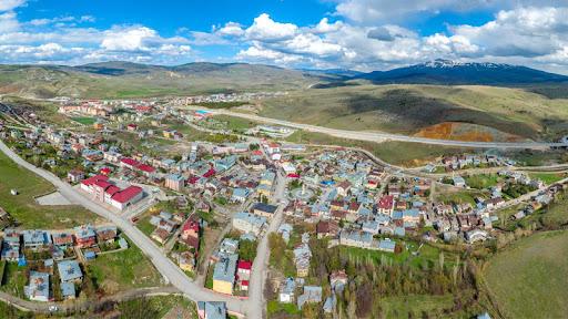
Refahiye (District)
Refahiye (District)
Province | Erzincan | ||||||||
|---|---|---|---|---|---|---|---|---|---|
Elevation | Approximately 1,500 metres | ||||||||
Area | 1,744 km² | ||||||||
Climate | Continental and Black Sea transitional climate | ||||||||
Natural Attractions | Dumanlı Yaylaları, Soğukgöze, Gülendağı | ||||||||
Local Cuisine | Leafy dumplings, chopped soup, water börek | ||||||||
Refahiye is a district of Erzincan Province, notable for its natural beauty and historical fabric.Eastern Anatolia, situated at the intersection of the Black Sea and Central Anatolia regions, has endowed the district with both geographical and cultural diversity. Located 71 km from the provincial center, Refahiye covers an area of 1,744 km².
The history of Refahiye dates back to its former name, Gercanis. Between 1566 and 1871, Gercanis was subordinate to the Kemah Sanjak. In 1872, due to its mountainous and steep terrain, it was relocated to its present location. Established as a district center in 1882, Refahiye was named by Erzincan Mutasarrıf Şerif Paşa in 1884, with “Refahiye” meaning “abundance”.
Refahiye features a mountainous landscape and encompasses natural attractions such as Kızıldağ and Gülendağı. The northern part of the district is influenced by the Black Sea climate, while the southern part is dominated by the continental climate of Eastern Anatolia. This condition manifests in harsh winters and short, cool summers.
According to 2024 data, the population of Refahiye is 11,609, of whom 6,094 are male and 5,515 are female. The district includes 121 villages and 73 hamlets.
The economy of Refahiye is based on agriculture and animal husbandry. Crops such as wheat, barley, legumes, walnuts, melons and watermelons are cultivated. Additionally, honey production is an important source of income. The annual honey festival held in August contributes significantly to the district’s economic and cultural life.
Refahiye possesses rich tourism potential due to its natural beauty and historical structures. The Dumanlı Yaylaları, located between the Soğukgöze and Karaçam areas, offer opportunities for both summer and winter tourism.
Historical structures in the district include the Kutlutepe Ruins, Kadıköy Church, Merkez Camii and Köroğlu Cave. The local cuisine reflects the characteristics of Erzincan cuisine, with notable dishes such as yaprak döner, kesme çorbası and su böreği.
Kadıköy Church has survived to the present day in relatively good condition. The entrance door, made of cut stone, is notable for its decorative elements. A cross motif is carved in relief on the threshold stone above the door. Traces of wall paintings remain inside the church. In front of the apse, there is a finely crafted wooden panel with ornamental details.
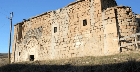
Kadıköy Church (Cultural Inventory)
The Merkez Mosque in Refahiye district of Erzincan was constructed in the second half of the 19th century. As its foundation inscription has not survived, the builder and exact construction date remain unknown.
The mosque, built entirely of local cut stone, is entirely influenced by Western architectural styles. This is evident from its entrance door and pointed-arch windows, which suggest that its builders and craftsmen were inspired by church architecture. It has a rectangular plan and is covered by a gabled roof.
Above the entrance door, the continuation of the roof forms a triangular pediment. The minaret, with a round body on a stone base, is constructed of cut stone and has a single balcony. Within a large courtyard, the mosque’s cemetery includes the Bahattin Paşa Martyrdom Site.
Located in the western part of Refahiye district, between the Soğukgöze and Karaçam areas, the Dumanlı Plateau lies directly south of the district center. At an elevation of 2,000 meters above sea level, the plateau is predominantly covered by pine forests, meadows and vegetation. Its natural beauty, clean air, abundant cold water springs, wildlife and camping facilities make it suitable for both summer and winter tourism.
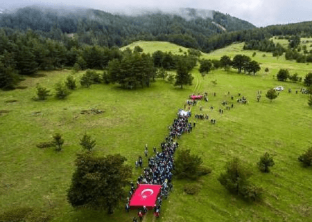
Dumanlı Plateau (Republic of Türkiye Refahiye District Governorship)
T.C. Erzincan Valiliği. "Doğal Güzellikler." T.C. Erzincan Valiliği Resmi Web Sitesi. Accessed April 15, 2025.http://erzincan.gov.tr/dogal-guzellikler1.
T.C. Erzincan Valiliği. “Refahiye.” T.C. Erzincan Valiliği Resmi Web Sitesi. Accessed April 15, 2025.http://www.erzincan.gov.tr/refahiye.
Turkey Outdoor. "Erzincan Refahiye İlçesi Tanıtımı." Turkey Outdoor, October 1, 2023. Accessed April 15, 2025.https://turkeyoutdoor.org/erzincan-refahiye-ilcesi-tanitimi/.
Refahiye (District)
Refahiye (District)
Province | Erzincan | ||||||||
|---|---|---|---|---|---|---|---|---|---|
Elevation | Approximately 1,500 metres | ||||||||
Area | 1,744 km² | ||||||||
Climate | Continental and Black Sea transitional climate | ||||||||
Natural Attractions | Dumanlı Yaylaları, Soğukgöze, Gülendağı | ||||||||
Local Cuisine | Leafy dumplings, chopped soup, water börek | ||||||||
No Discussion Added Yet
Start discussion for "Refahiye (District)" article
History
Geography and Climate
Population and Demographics
Economy
Tourism
Kadıköy Church
Merkez Mosque
Dumanlı Plateau