This article was automatically translated from the original Turkish version.
+2 More
Kula (District)
Province | Manisa | ||||||||
|---|---|---|---|---|---|---|---|---|---|
Geographic Region | Aegean Region | ||||||||
Population | 43.227 (2022) | ||||||||
District Governor | Ömer Ahmet Özdemir | ||||||||
Mayor | Hikmet Dönmez | ||||||||
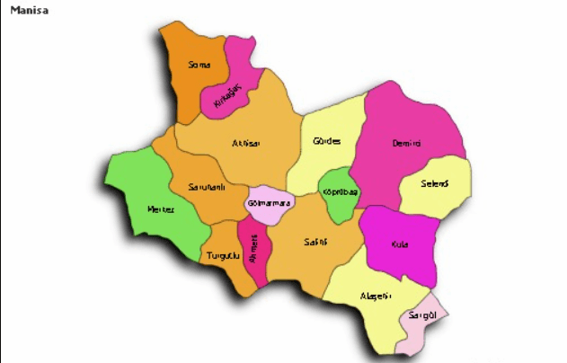
Kula district is located in the eastern part of Manisa province, within the Inner Western Anatolia region of the Aegean Region. The district is known for its volcanic structure and geological features, situated in the area known as Katakekaumene (Burnt Land). Kula is a settlement where agriculture, animal husbandry, and small-scale industrial activities are carried out.
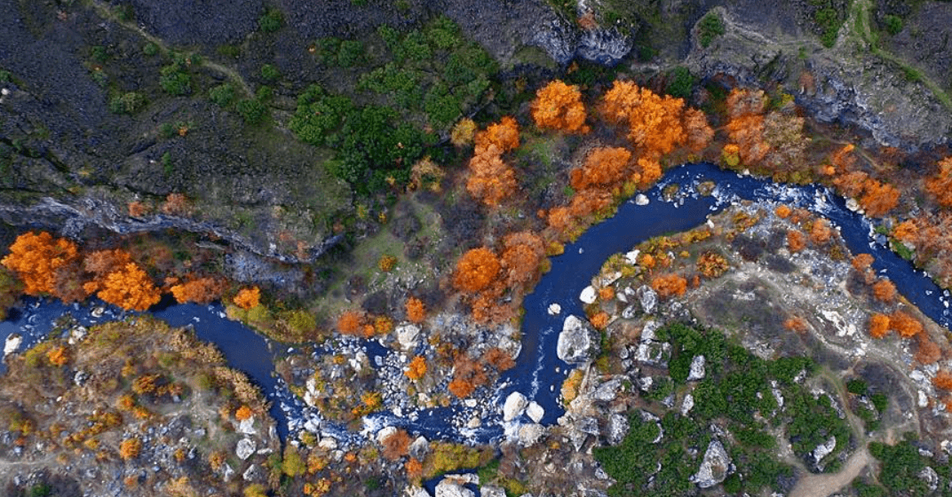
Kula (District) - (Anadolu Ajansı)
Kula district, under the administration of Manisa province, has been under the rule of various civilizations throughout its historical development and is one of the settlements with a deep-rooted past. In antiquity, it was known as “Katakekaumene” (Burnt Land). Ancient authors, beginning with the Amasya geographer Strabo, provided detailed descriptions of Katakekaumene’s ash-covered terrain, black cliffs, and eruption centers. These volcanic formations and lava coverings continue to define Kula’s characteristic geography today.
Although Kula’s early settlement history cannot be definitively established, ancient sources refer to the region by names such as Koloe, Opsukion, Clanudda, Katake, and Kamene. These names reflect the region’s history under the dominion of Ancient Lydia, Persia, Hellenistic, Roman, and Byzantine powers. However, archaeological evidence revealing urban structures from these periods remains limited. Historical records indicate that during the Byzantine period, Kula lay within the boundaries of the Opsikion Theme, one of the administrative-political units of Anatolia. Established in the 7th century, the Opsikion Theme was divided into two separate administrative regions in the 9th century. Byzantine historians such as Pachymeres noted that Kula was a fortified position frequently changing hands between Byzantine and Turkish forces.
The region came under Turkish rule in the early 14th century during the period of the Germiyanids. Historical records state that after I. Yakup Bey, his son Mehmet Bey recaptured Kula from the Catalan forces and incorporated it into the beylik. A stone endowment deed issued by II. Yakup Bey of the Germiyanids explicitly states that Kula was endowed “recovered from the infidels.” In the final period of the Germiyanid Beylik, Süleyman Şah formed an alliance with the Ottomans due to political conflicts with the Karamanids, marrying his daughter Devlet Hatun to Yıldırım Bayezid to establish a familial bond. As part of the dowry, Süleyman Şah ceded Kütahya, Tavşanlı, Simav, and Emet to the Ottomans, relocated to Kula, and made it the capital of the beylik. He died in Kula in 1388 and was buried in the Gürhane Medrese he had built there.
Ottoman rule began during the reign of Yıldırım Bayezid; after the Battle of Ankara in 1402, the territories of the Germiyanid Beylik were temporarily returned to II. Yakup Bey with Timur’s support. However, in 1429, following the will of II. Yakup Bey, the Germiyanid lands were permanently annexed to the Ottoman State. During this period, Kula was incorporated into the Ottoman administration as a kaza subordinate to the Kütahya Sanjak. In the 19th century, upon the proposal of the governor of İzmir, Kula was attached to the Saruhan Sanjak in 1852.
During the Ottoman period, Kula developed into an important industrial and commercial center. It reached a high level of expertise in crafts such as textiles, pottery, carpet weaving, and shoemaking, with its economic structure defined by these production-based activities. The municipal organization was among the earliest established within the Ottoman Empire; sources vary on its founding year, citing either 1866 or 1877. Municipal services continuously expanded, with basic infrastructure projects including pavement laying, road construction, and street lighting implemented. The first municipal building was constructed in 1903 on Yeni Hamam Street.
Electricity was first supplied to the district between 1924 and 1926 using diesel generators, later sourced from the Kula Textile Factory. The first modern slaughterhouse was constructed by the municipality in 1937. Kula’s water network was completed in 1954, providing the population with access to safe drinking water. Municipal services moved to a new building in 1963 and operated from various facilities over time to meet changing needs. Today, services are provided from a modern municipal building.
With the establishment of the Republic, Kula underwent significant transformations in its political and administrative structure. During the Greek occupation following World War I, the district was occupied on 28 June 1920 and was liberated and reintegrated into the administration of the Republic of Türkiye on 4 September 1922 following the Turkish army’s victory.
Kula district is located in the Inner Western Anatolia Region of the Aegean Region, under the administration of Manisa province. Its geographic coordinates lie between 38°53′ north latitude and 28°68′ east longitude, at an elevation of approximately 720 meters above sea level. The district covers an area of 917 km², constituting approximately 6.95% of Manisa province’s total area. Kula is bordered by Eşme district of Uşak to the east, Salihli to the west, Demirci and Selendi to the north, and Alaşehir to the south. Its strategic location along the İzmir-Ankara State Highway (D300), a major transportation corridor connecting the Aegean Region to Central Anatolia, enhances its strategic importance.
Manisa - Kula (Youtube)
The district generally features a mountainous and rugged topography. Areas south of Divlit Mountain and surrounding volcanic hills reinforce this geographical character. Kula is built upon one of Turkey’s youngest volcanic regions and possesses a highly dynamic geological structure. The soils of the district exhibit great diversity as a product of volcanic activity and long-term geological processes, primarily shaped by basaltic lava flows and tuff layers.
The fairy chimneys prevalent in the Kula region were formed by the erosion of Miocene, Pliocene, and Quaternary-aged sediments by the Gediz River and its tributaries. These geomorphological formations constitute key elements of the district’s unique natural landscape and are located within the volcanic area known as Katakekaumene (Burnt Land). This area holds significant potential not only geologically but also in terms of tourism, education, and geoheritage.
The high plateaus within the district generally decrease in elevation from east to west. Among these plateaus, Ulucak, Şehitler, and Encekler are the most prominent. The Gediz River, along with the Selendi, Söğüt, and Hacılar streams, constitute the main watercourses of the district. Although river flows diminish during summer months, they exhibit strong and consistent flow during winter due to increased rainfall.
In terms of climate, Kula lies in a transitional zone between Mediterranean and continental climate types. Its high elevation and distance from the sea result in a pronounced continental character. This climatic structure directly influences the natural vegetation. The region features a mosaic of maquis and shrubland formations dominated by sun-loving, drought-resistant sclerophyllous species, interspersed with forested areas.
Soil types are highly diverse. Alluvial soils are common in the district center and along river courses. Basaltic soils predominate in the northern and western areas. Wider areas are covered by calcareous brown forest soils and rendzina-type Mediterranean soils. This diversity enriches the district’s agricultural potential and natural vegetation.
Geologically, Kula lies within the Anatolid Belt, one of Anatolia’s major tectonic zones. The district contains rock formations of varying ages and origins spanning from the Precambrian to the present. Metamorphic and crystalline structures belonging to the Menderes Massif are overlain by Pliocene and Quaternary volcanic rocks, creating extensive geological diversity. Kula’s volcanic rocks, represented by basalt, tuff, and agglomerates, are young formations indicating three main phases of volcanic activity occurring in different periods.
Located in the eastern part of Manisa province, Kula district had a total population of 43,361 as of 2023. With an area of 917 km², the district’s average population density is approximately 44.2 people/km², below the Manisa provincial average of 110.62 people/km², reflecting its rural character and relatively sparse settlement pattern.
The median age in Kula district is 42.20, higher than the national average of 34.00 and close to the Manisa provincial median age of 37.33. This indicates a relatively older population. When examining dependency ratios by age group, the child dependency ratio is 23.78% and the elderly dependency ratio is 22.63%. The total dependency ratio stands at 46.42%, consistent with the Manisa provincial average (46.99%) and the national average (46.34%).
The district’s population structure has remained relatively stable over the years, but the declining proportion of youth and the relative increase in the elderly population indicate a demographic transition. This trend is associated with declining fertility rates, rural-to-urban migration, and the movement of young populations toward major cities.
The economy is largely based on agriculture, animal husbandry, and to a lesser extent tourism, preserving the district’s rural character. Trade, the service sector, and small-scale industry also serve as complementary economic components.
Kula district possesses significant agricultural production potential. According to TÜİK data from 2011–2019, 35,563 hectares of land are used for agricultural activities. Of this area, 81.6% is dedicated to cereal production, 5.13% to vegetables, and 13.81% to fruits. The volcanic terrain significantly influences Kula’s agricultural output; the mineral richness of volcanic soils enhances the productivity of certain fruits and vegetables.
Cereal farming forms the backbone of Kula’s economy. In 2019, a total of 161,404 tons of cereals were produced. Major cereal crops include maize (for silage), fava beans (yeşilot), barley, and durum wheat. Among these, fava beans and durum wheat hold considerable shares in both Manisa and national production. For instance, Kula contributes 62% of Manisa’s fava bean production and 6.36% of Turkey’s total. Similarly, in sesame seed production, Kula accounts for 45.71% of Manisa’s output and 9.24% of Turkey’s total.
Vegetable cultivation, though more limited than cereal production, plays an important role in the local economy. In 2019, 35,922 tons of vegetables were produced. The most prominent vegetables include watermelon (14,149 tons), processing tomatoes (4,677 tons), table tomatoes (4,651 tons), and cantaloupe (3,695 tons). Kula also holds significant shares in national and provincial production of cauliflower, pickling cucumbers, fresh broad beans, and spinach.
Fruit production is another vital component of Kula’s economy. According to 2019 data, a total of 10,031 tons of fruit were produced. Major fruit crops include walnut, almond, strawberry, and wine grapes. Walnut production, covering 36.5% of cultivated land, is a major income source for the district. Strawberry production, once substantial, has declined in recent years.
Animal husbandry, alongside agriculture, constitutes the second pillar of Kula’s economy. According to TÜİK 2019 data, the district has 47,833 head of large livestock and 119,087 head of small livestock. Large livestock farming accounts for 19.23% of Manisa’s total, while small livestock farming represents 8.35%. Nationally, Kula contributes 0.27% of Turkey’s large livestock and 0.15% of its small livestock production.
Large livestock farming focuses on milk and meat production, while small livestock farming centers on goat and sheep rearing. Additional activities include beekeeping, poultry farming, and partially sericulture. Animal products such as milk, wool, and honey are important for both local consumption and market supply.
Industrial activity in Kula is limited but includes small-scale agro-based processing facilities. These include packaging and processing plants for walnuts, grapes, and cereals, as well as some flour and feed mills. Traditional crafts and ceramics also form part of small-scale production and trade.
Kula’s commercial life is primarily centered on agricultural trade with the district center and neighboring districts. Weekly markets serve as important sales points for local producers. In recent years, cooperative initiatives have accelerated, with producer cooperatives established for products such as walnuts and grapes.
Following agriculture and animal husbandry, tourism represents the most significant potential sector in Kula’s economy. Historic Kula houses, the Kula Volcanic Geopark, and its rich geological heritage make the district attractive to tourists. With the growth of tourism, activity has increased in accommodation, food and beverage services, and souvenir trade.
Kula is one of the rare settlements that has preserved the characteristic urban structure of the Ottoman period to the present day. The Kula houses, dating from the 18th and 19th centuries, represent some of the most original and best-preserved examples of Ottoman architecture in Anatolia. Constructed using a wooden frame system with wattle-and-daub infill on stone foundations, these houses are typically two-story, with upper floors projecting over the street and featuring tiled, ornate gabled roofs. Wooden shutters, decorated ceilings, intricately crafted wooden cabinets, and hearths are distinctive features of these homes.
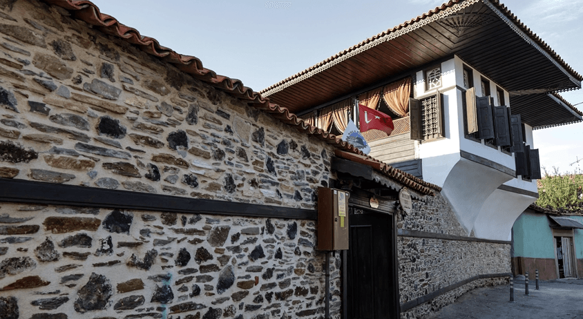
Historic Kula Houses (Anadolu Ajansı)
The Kula houses reflect the Ottoman lifestyle’s emphasis on privacy, with wide courtyards and high walls. Ground floors housed stables, storage, and kitchens, while upper floors served as living and reception areas. The main room, known as the “baş oda,” was reserved for guests and enriched with detailed wooden ornamentation.
Kula’s dense street layout, developed according to a castle-centered settlement logic, is a classic example of organic urban planning. Narrow, winding streets are typically wide enough for a pack animal to pass. This unique urban structure has earned Kula the title of “Monumental Town” and necessitated the preservation of its historical fabric.
Kula hosts Türkiye’s and the Turkish world’s first and only UNESCO-recognized global geopark. Kula-Salihli UNESCO Global Geoparkcovers an area of 2,320 km² and encompasses the Gediz Graben and the western sections of the Western Anatolian plateaus.
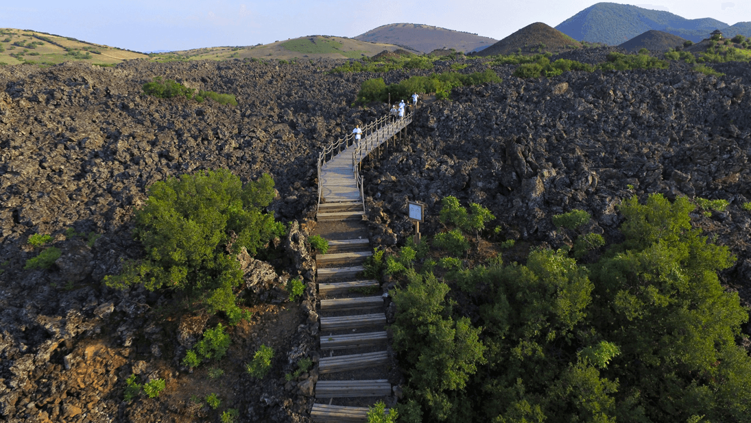
Global Geopark (Anadolu Ajansı)
The geopark is distinguished by rock formations, volcanic structures, and tectonic features dating back over 200 million years. As one of Türkiye’s youngest volcanic areas, it hosts numerous geological formations including lava flows, basalt columns, lava caves, fault lines, and alluvial fans. Archaeological and prehistoric findings such as human footprints in Çakallar and rock paintings at Kanlıkaya further enrich the region’s geological heritage with cultural significance.
The geopark is not merely a geological site but also holds significant potential for nature hiking, geological photography, scientific research, and environmental education. The Kula Geopark Visitor Center and the Geopark Research Center (JARUM) offer visitors scientifically enriched experiences.
The Kula Fairy Chimneys are among the district’s most striking natural heritage features. These formations, located within the Burgaz Volcanite Zone, resulted from the interaction of lava flows with fluvial sediments. On a plateau where basaltic lava reached thicknesses of 30–40 meters, wind and rain erosion have sculpted extraordinary shapes.
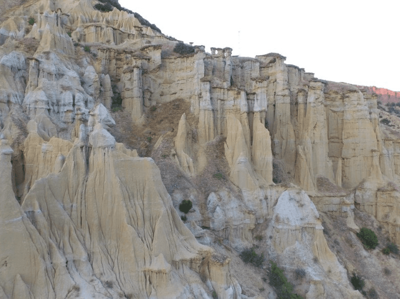
Fairy Chimneys (Kula Kaymakamlığı)
The fairy chimneys, together with the surrounding badlands-type eroded terrain, create an impressive landscape. These natural formations offer a unique visual spectacle for photographers and nature enthusiasts. The ancient sediments on either side of the valley form extraordinary geomorphological shapes shaped by natural processes, and the region continues to undergo active geological change.
Akbaş, Ferdi. “Kula İlçesinin Genel Fiziki Coğrafya Özelliklerinin Coğrafi Bakış Açısıyla İncelenmesi.” *Sosyal ve Beşeri Bilimler Dergisi* 11, no. 21 (2023): 157–179. Accessed June 20, 2025.https://sobibder.org/index.php/sobibder/article/view/79/77
Anadolu Ajansı. "Restore Edilen Asırlık Kula Evleri Turizme Hizmet Ediyor." Anadolu Ajansı, November 9, 2022.https://www.aa.com.tr/tr/kultur/restore-edilen-asirlik-kula-evleri-turizme-hizmet-ediyor/2718116.
Anadolu Ajansı. "UNESCO Sertifikalı Kula Jeoparkı Yeniden Tescil Sürecinde." Anadolu Ajansı, August 11, 2019.https://www.aa.com.tr/tr/turkiye/unesco-sertifikali-kula-jeoparki-yeniden-tescil-surecinde-/1534453.
Anadolu Ajansı. “Kula Volkanik Jeoparkı'nda Sonbahar.” *aa.com.tr*, November 15, 2017. Accessed June 20, 2025.
Ege, İsmail. “Kula (Kula/Manisa) Peribacalarının Jeomorfolojik Özellikleri ve Oluşumlarında Erozyon Etkisinin RUSLE Yöntemi ile Belirlenmesi.” *Journal of Artificial Societies and Social Simulation* 6, no. 1 (2019): 41–60. Accessed June 20, 2025.https://www.researchgate.net/publication/332032061
Jeopark Belediyeler Birliği. "Kula Bölgesi." Accessed June 25, 2025.https://jeoparkbelediyelerbirligi.com/s15_kula-bolgesi.aspx.
Jeopark Belediyeler Birliği. "Tarihi Kula Evleri." Accessed June 25, 2025.https://jeoparkbelediyelerbirligi.com/s84_tarihi-kula-evleri.aspx
Kula Belediyesi. "Belediye Tarihçesi." Accessed June 20, 2025.
Kula Belediyesi. "İlçe Ekonomisi." Accessed June 25, 2025.https://www.kula.bel.tr/sayfa/ilce-ekonomisi/
Kula Belediyesi. “Coğrafi Durum.” Accessed June 20, 2025.
Kula Kaymakamlığı. "Kula’da Gezilecek Çok Yer Var: Kula Peribacaları." Accessed June 25, 2025.http://www.kula.gov.tr/kulada-gezilecek-cok-yer-var-kula-peribacalari.
Kula Kaymakamlığı. “İlçemiz Tarihçesi.” Accessed June 20, 2025.
Manisa Vergi Dairesi Başkanlığı. *Kula İlçesi Vergi İstatistikleri.* Accessed June 20, 2025.
Manisa İl Kültür ve Turizm Müdürlüğü. "Kula." Accessed June 20, 2025.
Palamutcuoglu, Türker. "Kula’nın Tarım Üretimi Potansiyeli." Chapter, December 2020.https://www.researchgate.net/publication/347003193_Kula'nin_Tarim_Uretimi_Potansiyeli.
T.C. Ministry of Industry and Technology,Zafer Kalkınma Agency. *Manisa İli Genel Sosyoekonomik Görünümü*. Accessed June 20, 2025.
Taşlıgil, Nuran. “Manisa İlinin Nüfus Gelişimi ve Özellikleri.” *Türkiyat Araştırmaları Enstitüsü Dergisi* 40 (2009): 231–258. Accessed June 20, 2025.
Türkeçan, Ahmet, Tuncay Broan, Ali Münci Ejder, and Erdoğdu Günay. “Kula-Selendi (Manisa) Dolaylarının Jeolojisi.” *Maden Tetkik ve Arama Dergisi* 115 (1993): 43–65. Accessed June 20, 2025.https://dergipark.org.tr/en/download/article-file/284225
UNESCO Türkiye Milli Komisyonu. "UNESCO Küresel Jeoparkları." Accessed June 25, 2025.https://www.unesco.org.tr/Pages/129/126/UNESCO-K%C3%BCresel-Jeoparklar%C4%B1
YouTube. "Kula Volkanik Jeoparkı Tanıtım Videosu." Published by: Manisa Valiliği. Accessed June 20, 2025.

Kula (District)
Province | Manisa | ||||||||
|---|---|---|---|---|---|---|---|---|---|
Geographic Region | Aegean Region | ||||||||
Population | 43.227 (2022) | ||||||||
District Governor | Ömer Ahmet Özdemir | ||||||||
Mayor | Hikmet Dönmez | ||||||||
History
Geographical Features
Demographic Structure
Economic Structure
Agriculture
Cereal Production
Vegetable Production
Fruit Production
Animal Husbandry
Industry and Trade
Tourism and Service Sector
Tourism
Historic Kula Houses and Urban Fabric
Kula-Salihli UNESCO Global Geopark
Kula Fairy Chimneys and Natural Formations