


This article was automatically translated from the original Turkish version.
+1 More
Keban (District)
Keban
Province | Elazığ | ||||||||
|---|---|---|---|---|---|---|---|---|---|
Region | Eastern Anatolia Region | ||||||||
Climate | Continental Climate | ||||||||
Area | 641 km² | ||||||||
Elevation | 780 metres | ||||||||
Population | 6.629 (2024) | ||||||||
Mayor | Yücel DOĞAN | ||||||||
District Governor | Furkan ATALIK | ||||||||
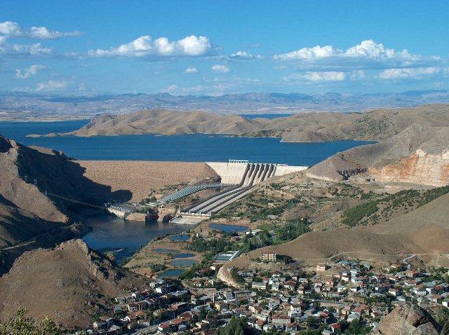
Keban is a district of Elazığ Province in the Eastern Anatolia Region of Türkiye. Located approximately 46 kilometers from the city center of Elazığ, it is situated on the Euphrates River. The district holds a strategic position at the regional level due to its dams and water resources.
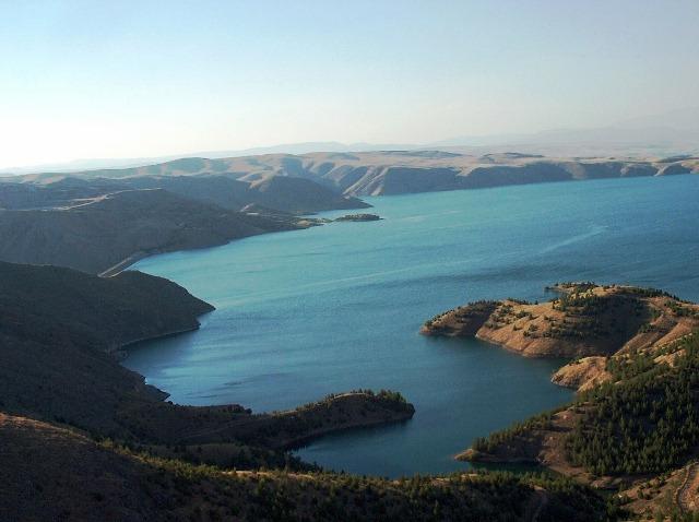
Keban Dam Lake (Source: Elazığ Provincial Directorate of Culture and Tourism)
Keban district is located in the western part of Elazığ Province. It is bordered by Elazığ Center to the east, Malatya’s Arapgir district to the west, Ağın and Baskil to the north, and Sivrice district to the south. The district covers an area of 641 square kilometers and its topography is predominantly mountainous and rugged. The extensions of the Palu Mountains and various elevations are found in the region. The Euphrates River forms a significant portion of Keban’s natural boundaries. The Keban Dam Lake, located in the western part of the district, is the second largest artificial lake in Türkiye. The climate is characterized by a continental climate with hot and dry summers and cold, snowy winters.
The settlement history of Keban and its surroundings can be traced back to the Chalcolithic Age. Archaeological studies in the region have demonstrated continuous habitation since prehistoric times. Numerous civilizations including the Hittites, Urartians, Persians, Romans, and Byzantines have held dominion over the area. During the Ottoman period, Keban was recorded as a settlement under the Harput Sanjak.
During the Republican era, Keban was initially a neighborhood under Elazığ and became a district in 1967.
Administratively, Keban district consists of one central municipality, one town (Zırki/Altınoluk), and 30 villages. According to data from the Turkish Statistical Institute (TÜİK), the district’s population has fluctuated over the years. Economic and social migration trends, particularly from the 1980s onward, have led to a decline in population. Rural population density is higher compared to the urban center. The district governorship and the municipality constitute the primary administrative units.
Keban’s economy is primarily based on agriculture, animal husbandry, fishing, and the service sector. Although there are no large-scale industrial activities in the district, some local manufacturing and service enterprises operate at a small scale. The Keban Dam Lake offers significant potential for freshwater fishing. Trout production forms the core of aquaculture activities in the district.
In agriculture, fruit and vegetable cultivation as well as viticulture are prominent. Animal husbandry activities are mainly focused on small livestock.
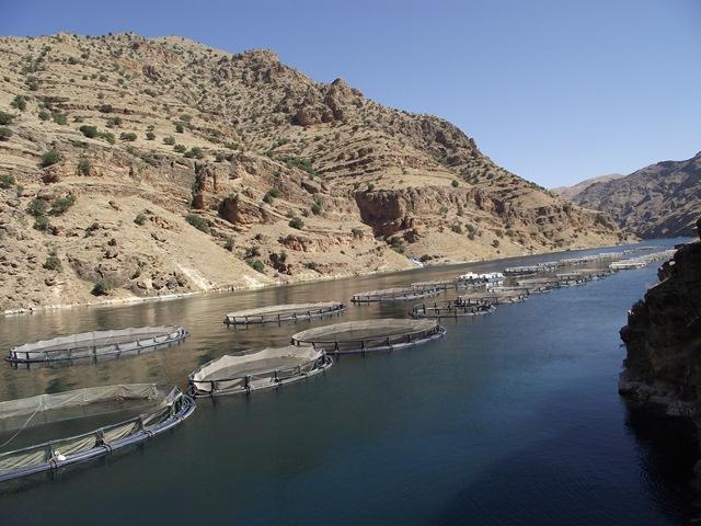
Keban Fish Farm (Source: Elazığ Provincial Directorate of Culture and Tourism)
The district is accessible by road via the Elazığ-Keban route, which connects it to the provincial center. Additionally, a bridge and ferry system located on the Keban Dam enable access to settlements on the opposite bank of the river. Apart from road transport, the district has no other transportation infrastructure. In rural areas, transportation is largely conducted via village roads.
Keban district has public schools offering education at various levels. Primary and secondary education institutions operate in the district center and some villages. Vocational education schools are also present. A vocational college affiliated with Fırat University conducts educational activities in the district.
Health services are provided through the district state hospital and several health centers. There are no private healthcare facilities. The district occasionally faces limitations in terms of healthcare personnel and technical infrastructure.
Keban district is home to various cultural heritage elements. Keban Stone Bridge, Kalecik Cave, Rock Tombs, Sırçalı Cave, and ancient period ruins form the cultural and archaeological identity of the district. These sites serve as important sources for historical and archaeological research.
The area surrounding the Keban Dam Lake attracts attention through recreational areas, natural observation points, and fishing activities. These tourism-potential sites are utilized for various recreational purposes. Annual local events and festivals held in the district contribute to the preservation of regional cultural values.
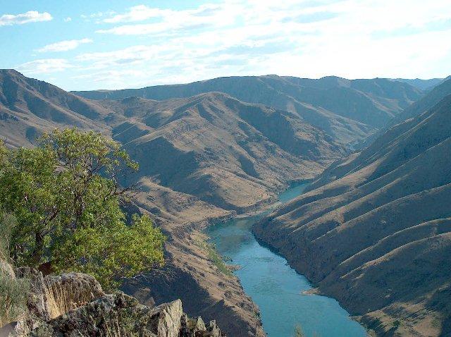
Murat River (Source: Elazığ Provincial Directorate of Culture and Tourism)
Keban Belediyesi. "Gezi Rehberi." Accessed April 21, 2025.http://www.keban.bel.tr/gezi-rehberi.html.
Keban Belediyesi. "İlçemiz." Accessed April 21, 2025.http://www.keban.bel.tr/ilcemiz.html.
Keban Kaymakamlığı. "Tarihçe." Accessed April 21, 2025.http://www.keban.gov.tr/tarihce.
Keban Kaymakamlığı. "İlçemiz." Accessed April 21, 2025.http://www.keban.gov.tr/ilcemiz.
Ministry of Culture and Tourism. "Keban." Accessed April 21, 2025.https://elazig.ktb.gov.tr/TR-58512/keban.html.

Keban (District)
Keban
Province | Elazığ | ||||||||
|---|---|---|---|---|---|---|---|---|---|
Region | Eastern Anatolia Region | ||||||||
Climate | Continental Climate | ||||||||
Area | 641 km² | ||||||||
Elevation | 780 metres | ||||||||
Population | 6.629 (2024) | ||||||||
Mayor | Yücel DOĞAN | ||||||||
District Governor | Furkan ATALIK | ||||||||
Geography
History
Population and Administrative Structure
Economy
Transportation
Education and Health
Cultural Structure and Tourism