


This article was automatically translated from the original Turkish version.
+1 More
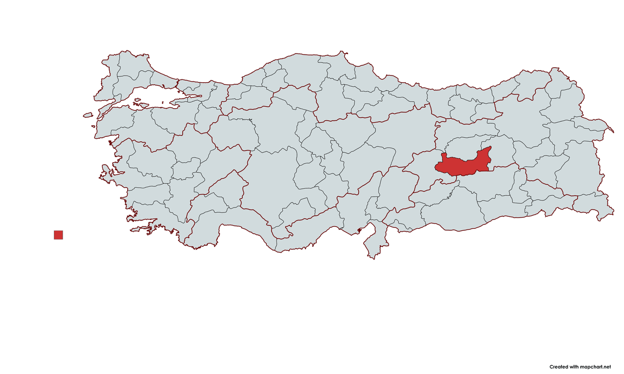
Elazığ
Country | Türkiye | ||||||||
|---|---|---|---|---|---|---|---|---|---|
Region | Eastern Anatolia | ||||||||
Population | 603941 | ||||||||
Area | 9153 km² | ||||||||
Climate | Continental Climate | ||||||||
Important Structure | Harput Castle/Keban Dam/Harput Grand Mosque | ||||||||
Governor | Karasal Hatipoğlulları | ||||||||
Mayor | Şahin Şerifoğulları | ||||||||
License Plate | 23 | ||||||||
Area Code(s) | 424 | ||||||||
Elazığ is a province located in the heart of Eastern Anatolia, distinguished by its rich history, cultural heritage, and natural beauty. This region has served as a home to numerous civilizations throughout history, including the Hittites, Urartians, Romans, and Byzantines. Etymologically, it has been known by various names such as Harput, Ma’muretü’l-Aziz, and Elaziz, and is now known as Elazığ. Its modern economic structure is supported by industries such as industry, agriculture, mining, and livestock farming, while also attracting attention through its dynamic culture and tourism opportunities.
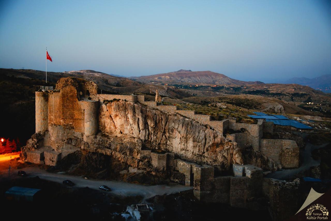
(Harput Kalesi).
Elazığ and its surroundings have been under the dominance of various civilizations throughout history and have been known by different names. The region’s name has changed over time according to the linguistic and cultural influences of the ruling powers.
Elazığ is a historic city located in the Eastern Anatolia Region, within the Upper Euphrates Basin. To understand Elazığ’s history, one must examine the past of its origin, Harput. Harput has served as a home to various civilizations and is among the region’s oldest settlement areas. The current location of Elazığ emerged as a result of Harput losing its strategic importance in the 19th century and the city’s search for a new center.
The earliest settlement traces in the Elazığ and Harput region extend back to the Paleolithic Age. Archaeological excavations have uncovered remains from the Neolithic, Chalcolithic, and Bronze Ages. It is known that the Hurrians settled in the region around 2000 BCE. During the Hittite period, Harput and its surroundings were referred to as “Išuwa.”
In the 9th century BCE, Harput came under Urartian dominance and developed as a fortified city, with Harput Castle being constructed during this period. One of the most significant artifacts left by the Urartians in the region is Palu Castle. With the decline of the Urartians, the Medes and Persians gained control of the area.
The region came under the control of the Roman Empire in 66 BCE and remained within Byzantine territory after the division of the Roman Empire in 395 CE. During the Byzantine period, Harput became an important military center, and its walls were reinforced. In the 7th century, the region became a battleground for Arab raids and frequently changed hands between the Umayyads and Abbasids and the Byzantines.
In the 7th century, the region came under Muslim control during the conquests under Caliph Umar. Muslim armies reached the Elazığ and Harput region in 639 and captured these territories from the Byzantines. However, due to Byzantine resistance and the region’s strategic importance, this control was intermittent.
During the Umayyad period, raids continued but permanent control was not achieved. Under the Abbasids, Byzantine dominance in the region significantly weakened, and by the 9th century, Harput began to come under Islamic administration. In the 10th century, Kurdish and Arab-origin states such as the Hamdanids and Mervanids gained control, but the region changed hands again following Byzantine counterattacks in the early 11th century. After the Seljuks’ decisive victory at the Battle of Manzikert in 1071, permanent control was established, and Harput became part of Turkic-Islamic governance.
Following the Battle of Manzikert in 1071, Harput was conquered by the Çubukoğulları in 1085, and a beylik was established in the region. However, this beylik was short-lived, and in 1110, control was taken over by the Artuqids. The Artuqid period witnessed major architectural developments in Harput. The Harput Ulu Mosque, constructed during this time, is considered one of the most important Islamic monuments in the region. In 1234, Seljuk Sultan I. Alaeddin Keykubad took Harput from the Artuqids and incorporated it into Seljuk territory.
Harput was incorporated into Ottoman territory in 1516 after Yavuz Sultan Selim’s campaign following the Battle of Chaldiran. During the Ottoman period, Harput was administered as a sanjak center subordinate to the Diyarbakır Eyalet. In the 16th and 17th centuries, the city became an important center of trade and craftsmanship, with leatherworking, coppersmithing, and textiles being key economic activities.
In the mid-19th century, due to Harput’s fragmented topography and declining strategic importance, the Ottoman administration established a new settlement at Agavat Mezrası, the present-day location of Elazığ. In 1867, this settlement was named “Ma’muretülaziz” in honor of Sultan Abdülaziz, and over time, it became commonly known among the public as “Elaziz.”
After the proclamation of the Republic, the city’s name was changed to “Elazık” during Atatürk’s visit in 1937, and was later formalized as “Elazığ,” the name still in use today. During the Republican era, Elazığ underwent significant development in industry, trade, and education. The establishment of Fırat University in 1975 transformed the city into an educational center.
Today, Elazığ continues to be one of the key centers of Eastern Anatolia, thanks to its progress in industry, agriculture, and education. The historical heritage of Harput remains an inseparable part of Elazığ’s cultural identity.
Elazığ Province is located in the southwest of the Eastern Anatolia Region, specifically within the Upper Euphrates Section. Covering an area of approximately 9,151 km², or 1.2% of Turkey’s total land area, the province lies between 38°30’ and 40°21’ east longitude and 38°17’ and 39°11’ north latitude. This strategic location makes Elazığ one of the important transit points in the region.
To the east, it borders Bingöl; to the north, Tunceli via the Keban Dam Lake; to the west and southwest, Malatya via the Karakaya Dam Lake; and to the south, Diyarbakır. Including the provincial center, the province comprises 11 districts, 537 villages, and 709 mezra settlements, reflecting the diversity of the region’s socioeconomic structure and local governance. Natural boundaries are defined by various topographical features such as mountains, plains, and river valleys, shaping the province’s overall geographical structure.
Elazığ’s terrain is generally mountainous and rugged, although the city center is built on a relatively flat area.
Average elevation: 1,067 meters
Mountainous areas are found in the west and north, while plains lie in the south.
High mountain ranges are located in the districts of Baskil, Sivrice, and Maden, while relatively flatter areas are found in the central and Kovancılar districts.
In Elazığ, arable plains and high plateaus play a significant role.
In addition, the eastern and northeast parts of Elazığ are covered by high plateaus, including:
Elazığ is one of the provinces through which the Euphrates River, one of Turkey’s largest rivers, flows. The Keban Dam and other water sources have shaped the region’s hydrological regime and ecosystem.
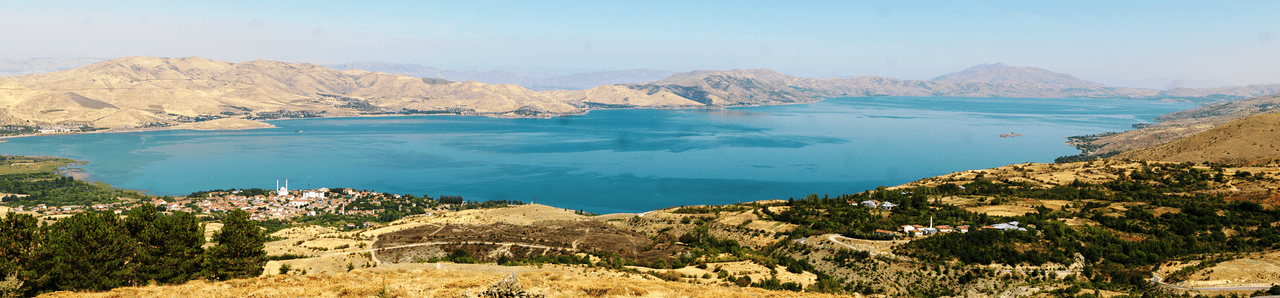
(Hazar Gölü).
Elazığ generally has a continental climate, with cold, wet winters and hot, dry summers. Winter temperatures can drop as low as -15°C.
The annual average precipitation is around 500–600 mm. However, the dam lakes surrounding the province (Hazar Lake, Keban Dam Lake, and Cip Dam Lake) contribute to local microclimatic effects, increasing humidity and moderating temperatures in certain areas. Topographic variation and altitude differences cause slight climatic variations between valleys and high plateaus, resulting in some areas having cooler conditions and others being more humid. These climatic differences have important implications for agriculture, livestock farming, and ecological balance in the region.
Vegetation: Steppe (bozkır) vegetation is widespread. Oak forests are found along the Euphrates River and in some mountainous areas. Irrigated agricultural lands have developed on plains and valley floors.
Elazığ possesses a geographically rich endowment of natural resources.
Minerals: Copper, fluorite, zinc, lead, chromium, manganese, molybdenum, iron, and tungsten are among the minerals found here.
Water Resources: Rivers such as the Murat River and Peri Stream are supported by large-scale projects like the Keban Dam.
Land Use:
50% pasture and meadow
28% agricultural land
12% forest areas
10% water surfaces
These natural resources enhance Elazığ’s economic, environmental, and ecological potential and play a vital role in the region’s sustainable development.
Elazığ lies on the Eastern Anatolia Fault Line and is therefore a region with high earthquake risk.
The 2020 Elazığ Earthquake (6.8 Mw) once again demonstrated the seismically active nature of the region.
The underground wealth of the region, particularly its mineral reserves, is especially noteworthy.
Elazığ has historically hosted diverse cultures and is notable for its geographical diversity and rich socioeconomic structure. Current demographic data reveal that the population is distributed unevenly across urban and rural settlements. This structure provides important insights into the lifestyles, economic activities, and local dynamics of the provincial center and surrounding districts.
According to TÜİK data, Elazığ’s total population is approximately 580,000 to 600,000. The majority of the population is concentrated in the provincial center, which offers modern infrastructure, education, healthcare, and commercial opportunities, while other districts exhibit lower population densities. This pattern highlights dynamic urban life in the city center and the persistence of traditional agricultural, livestock, and local production activities in rural areas.
Below are approximate population figures for Elazığ’s districts based on TÜİK and nufusu.com data:
In Elazığ, population distribution is particularly concentrated around the provincial center. Modern urban amenities, education, healthcare services, and commercial opportunities support strong migration toward the city center, while traditional lifestyles, agricultural production, and livestock farming dominate in rural areas.
Urban migration is a significant factor in the demographic structure. Particularly, the tendency of the young population to move toward large metropolitan areas in search of broader employment and educational opportunities has led to migration flows from certain parts of Elazığ. This situation can cause temporary population declines in urban centers and reshape socioeconomic dynamics. However, local development projects and infrastructure investments are viewed as measures to counterbalance this migration trend.
Mining Activities:
Elazığ, located in the heart of Eastern Anatolia, offers multifaceted experiences to both domestic and international visitors through its rich historical past, unique natural beauty, and vibrant cultural life. The city combines historical areas bearing traces of ancient civilizations, regional cuisine, sports, and adventure activities.
Harput, symbolizing Elazığ, preserves the traces of ancient civilizations through its castles, walls, and settlement areas. Harput holds great importance for both academic research and tourism.
Elazığ’s Harput Cuisine stands out with its rich flavors derived from local recipes and ingredients.
Water Resources:
Elazığ also attracts attention through nature-based sports and adventure activities:
Elazığ’s public administration is carried out through the Governorship, representing the central government, and the Municipality, serving as the heart of local governance.
The Elazığ Governorship, as the representative of the Turkish Republic government, is responsible for implementing state policies, ensuring public order and security, and managing administrative affairs. The Governorship operates through directorates active in various fields such as education, health, public order, social services, and disaster management. According to current data, Numan Hatipoğlu serves as the Governor of Elazığ. The Governorship plays a crucial role in implementing and coordinating state policies at the local level.
Local governance in Elazığ is carried out through the Elazığ Municipality and the district municipalities. This structure is active in areas such as infrastructure, urban planning, social and cultural services, economic development, and environmental regulation.
According to the 2024 local election results, the mayoralty of the metropolitan municipality was won by AK Party candidate Şahin Şerifoğulları. Regarding district municipalities: AK Party won four districts (Ağın, Arıcak, Maden, Center); Yeniden Refah Party won three districts (Alacakaya, Palu, Sivrice); Nationalist Movement Party won two districts (Baskil, Keban); Democratic Party won one district (Karakoçan); and BBP won one district (Kovancılar).
"Coğrafi Yapı."Elazığ Büyükşehir Municipality.
"Elazığ Genel Bilgiler." Kültür Portalı. Accessed [Date].https://www.kulturportali.gov.tr/turkiye/elazig/genelbilgiler
"Elazığ Tanıtım." FKA.https://fka.gov.tr/elazig-tanitim
"Elazığ Tarihi." Elazığ.gov.tr.
"Elazığ Tarihi." elazig.ktb.gov.tr.
"Elazığ." İslam Ansiklopedisi.
"Tarih."Elazığ Büyükşehir Municipality.
"İlimiz Hakkında."Elazığ Çevre and Urbanization Ministry. Accessed [Date].https://elazig.csb.gov.tr/ilimiz-hakkinda-i-681
Agriculture.Elazığ Büyükşehir Municipality.
Industrial and Commercial Affairs.Elazığ Büyükşehir Municipality.https://www.elazig.bel.tr/kent-rehberi/sanayi-ve-ticaret/249/
Secim. TRT Haber. Accessed February 22, 2025.
Ünsaldı, Mehmet. "ELAZIĞ’DA EKONOMİK FAALİYETLER VE SONUÇLARI." Fırat Üniversitesi Doğu Araştırmaları Dergisi 3, no. 2 (March 2005): 88-91.
Elazığ
Country | Türkiye | ||||||||
|---|---|---|---|---|---|---|---|---|---|
Region | Eastern Anatolia | ||||||||
Population | 603941 | ||||||||
Area | 9153 km² | ||||||||
Climate | Continental Climate | ||||||||
Important Structure | Harput Castle/Keban Dam/Harput Grand Mosque | ||||||||
Governor | Karasal Hatipoğlulları | ||||||||
Mayor | Şahin Şerifoğulları | ||||||||
License Plate | 23 | ||||||||
Area Code(s) | 424 | ||||||||
Etymology
Pre-Islamic Period
Post-Islamic Period
History
Ancient Period and the Foundation of Harput
Roman and Byzantine Period
Muslim Conquests and Islamic Rule
Seljuk and Beylik Period
Ottoman Period
Republican Era and Present Day
Geographical Structure
Location and Boundaries
Land Structure and Elevation
Important Mountains:
Plains and Plateaus
Rivers and Lakes
Important Rivers:
Important Lakes:
Climate and Vegetation
Natural Resources
Earthquake Risk and Geology
Demographics
General Population and Settlement Structure
Population Distribution by District
Demographic Trends, Socioeconomic Structure, and Urban Migration
Economy
Trade and Industrial Structure
Industry and Investments
Exports and Imports
Agriculture
Mining
Livestock Farming
Culture and Tourism
Historic Harput
Regional Cuisine – Harput Cuisine
Natural Beauties
Sports and Adventure Tourism
Administration
Central Representation
Local Governance