`murat-river` Related Article Results
Diyadin Hot Springs
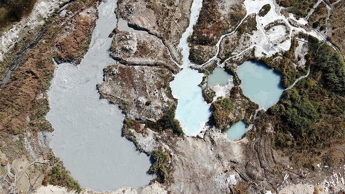
Diyadin Thermal Springs are a general term for thermal areas composed of natural hot water sources emerging from underground within the boundaries of Diyadin district, which is under the administration of Ağrı province in Eastern Anatolia Region of Türkiye. The springs are scattered along the valley of the Murat River south of the Diyadin district center and consist of multiple thermal sources known by different names such as Yılanlı, Davut, Tunca and Köprü Thermal Springs.Geographical LocationD
EN
Sümeyye Yırtıcı
 Pe
PePertek Castle
Located within the borders of Pertek district in Tunceli Province, Türkiye, Pertek Castle stands by the banks of the Murat River and has historically hosted various civilizations. Although its exact construction date remains uncertain, the castle underwent restoration during the Ottoman period. Today, due to the rising waters of the Keban Dam Lake, it appears as an island structure. The castle's integration with the natural landscape makes it notable both historically and as a tourist attraction
EN
Melike Saraç
PePertek Castle
Located along the banks of the Murat River within the boundaries of Pertek district in Tunceli province, Pertek Castle has historically served as a settlement for various civilizations and is today one of the region’s most significant cultural heritage sites. Although its exact construction date remains unknown, the castle underwent repairs during the Ottoman period and, due to submersion beneath the waters of the Keban Dam Lake, has now taken on the appearance of an island. Its integration with
ENMelike Saraç

Palu Bridge
Palu Bridge is a historic stone bridge located in the Palu district of Elazığ province in eastern Türkiye, spanning the Murat River. Built to connect the settlement with the river, the bridge lies along the east-west trade routes of Anatolia. With its engineering features and historical documentation, the structure is one of the representative examples of Ottoman-era stone bridge architecture in the region.Historical DevelopmentThe exact construction date of Palu Bridge is unknown; however, arch
EN
Fatma Köroğlu

Tutak (District)
Tutak is located on the western edge of the Murat River, amidst the high plateaus of Eastern Anatolia. The settlement lies within a broad plain surrounded by high mountains such as Çakmak, Kılıç, and Bozdağ.Winters in the region are long, cold, and snowy. Snow cover persists until the end of March. During summer, vegetation becomes lush and flower species diversify at higher elevations.Origin of the NameThere are three differing views regarding the origin of the name Tutak:Tutak Bey: The name is
EN
Ömer Keleş

Historical Murat Bridge
The Historical Murat Bridge is located within the boundaries of Muş, spanning the Murat River at place and is one of the historic bridges of Anatolia’s important. Although its exact construction date is unknown, based on its architectural features and regional historical records, it is generally accepted that the bridge was built during the Seljuk period in the 13th century. A stone inscription dated 1871 on the bridge indicates that it underwent restoration during the Ottoman period. Today, the
EN
Zehra Yayla

Keban (District)
Keban is a district of Elazığ Province in Türkiye's East Anatolia Region. Located approximately 46 kilometers from the center of Elazığ, it is situated on the Euphrates River. The district holds a regional significance due to its dam and water resources.Keban Dam Lake (Source: Elazığ Provincial Directorate of Culture and Tourism)" image-alternate="" image-element-format="right">GeographyKeban district lies in the western part of Elazığ Province. To the east it borders Elazığ Center, to the we
ENHelin Aksoy