


This article was automatically translated from the original Turkish version.
+2 More
January 24, 2020 Elazığ Sivrice Earthquake
Event | Elazığ Sivrice Earthquake | ||||||||
|---|---|---|---|---|---|---|---|---|---|
Date | 24 January 2020, 20:55 (local time) | ||||||||
Magnitude | Mw 6.8 (AFAD), Ml 6.6 (Kandilli) | ||||||||
Epicenter | Çevrimtaş Village, Sivrice, Elazığ | ||||||||
Focal Depth | 5 km | ||||||||
Loss of Life | 41 (35 Elazığ - 4 Malatya) | ||||||||
Injured | 1.607 | ||||||||
Affected Population | 47.800 (%13) | ||||||||
Damaged Building | 16.606 (38.548 independent units) | ||||||||
Urban Transformation | 20.160 housing constructions | ||||||||
Rental Assistance | 55.970.642 TL (to 7.210 people) | ||||||||
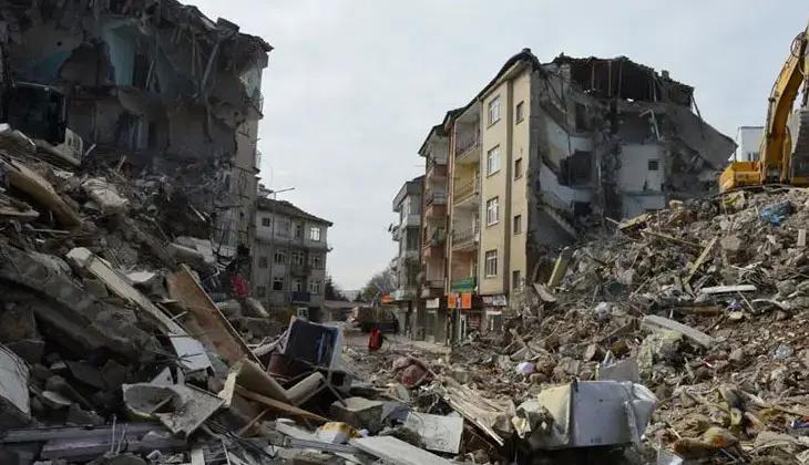
On 24 January 2020, a magnitude Mw 6.8 earthquake occurred with its epicenter in Çevrimtaş village of the Sivrice district in Elazığ. This shallow-focus earthquake took place along the Pütürge segment of the East Anatolian Fault System (EAFT) and was felt across Elazığ and neighboring provinces. The earthquake resulted in 41 fatalities, 1,607 injuries, and approximately 47,800 people directly affected. In the city center of Elazığ, about 13 percent of the 27,438 buildings sustained damage, with older building stock located on alluvial plains suffering severe damage.

Yıkılan Binalar (BBC)
Elazığ is located in the Upper Euphrates region of Eastern Anatolia, within a seismically active zone between the North Anatolian and East Anatolian Fault Zones. On 24 January 2020 at 20:55 local time, a magnitude Mw 6.8 earthquake occurred with its epicenter in Çevrimtaş village of Sivrice district. The earthquake’s focal depth was approximately 5 km, classifying it as a shallow-focus event. Boğaziçi University Kandilli Observatory recorded the magnitude as Ml 6.6 while AFAD recorded it as Mw 6.8. This difference stems from the use of different measurement methods (Richter scale and moment magnitude). The earthquake caused significant damage in Elazığ and Malatya, and was felt in surrounding provinces such as Adıyaman, Kahramanmaraş, Diyarbakır and Tunceli, though no major damage was reported in these areas.
The geological origin of the earthquake lies within the Pütürge segment of the East Anatolian Fault System. The EAFT is a left-lateral strike-slip transform fault extending from Karlıova in the northeast to Hatay in the southwest. The rupture occurred along an area approximately 50–55 km long and released energy equivalent to a 20-kiloton Hiroshima atomic bomb.
Geologically, Elazığ is built upon various units including alluvial plains, Keban Metamorphics, Elazığ Magmatics, Harami Formation, Kırkgeçit Formation and Karabakır Formation. Approximately 90 percent of the city center lies on alluvial plains, which amplify seismic waves and intensify damage. The amplification factor for alluvial soils ranges from 13–18 for silty clay, and 7–12 for sandy gravelly clay and sand-gravel, while it drops to 2–5 on more rigid substrates such as the Kırkgeçit Formation and Elazığ Magmatics.
The epicenter of the earthquake was located in Çevrimtaş village, 20 km from Sivrice district and 35 km from the center of Elazığ. According to AFAD data, the maximum ground acceleration recorded in Elazığ city center was 0.30 g, which is lower than the 0.40 g predicted by the Turkish Seismic Hazard Map. In Sivrice, the value was 0.63 g and in Doğanyol district of Malatya it reached 0.65 g. Between the mainshock and 8 February 2020, 1,185 aftershocks with magnitudes ranging from 1.2 to 5.1 occurred. Kandilli Observatory noted that the rupture occurred along a fault line approximately 40 km long and that the shaking in the epicentral region reached intensity VII (very strong) on the Mercalli Intensity Scale.
Following the earthquake, the Ministry of Environment, Urbanization and Climate Change initiated damage assessment surveys with 1,175 technical personnel and published final results on 17 February 2020. A total of 86,595 buildings (281,077 independent units) in Elazığ were inspected, of which 16,606 buildings (38,548 independent units) were classified as collapsed, urgently requiring demolition, or severely damaged. In the city center, 3,527 out of 27,438 buildings (13 percent) sustained damage, with 17,854 residential units falling into the categories of collapsed, urgently requiring demolition, severely or moderately damaged. Additionally, 4,663 independent units, mostly commercial establishments and warehouses, were damaged.
The neighborhoods suffering the most damage were Aksaray, Abdullahpaşa, Sürsürü, Mustafapaşa, Hicret and Sanayi, all located on alluvial plains and containing older building stock. For example, in Aksaray, 47 buildings were collapsed or urgently requiring demolition and 256 were severely damaged; in Abdullahpaşa, 371 buildings were damaged. In contrast, neighborhoods such as Safran, Çaydaçıra, Alayaprak, Esentepe and Hilalkent experienced low damage levels. Most of these areas are situated on more stable substrates such as the Kırkgeçit Formation or Elazığ Magmatics, or consist of newer building stock.
According to the Mercalli Intensity Scale, the earthquake was felt with intensities ranging from 5 to 8.5 in the city center. Neighborhoods including Aksaray, Kızılay, Mustafapaşa, Rüstempaşa, Nailbey, Çarşı, Rızaiye, İcadiye and Sarayatik, due to their alluvial soils and older building stock, experienced intensities of 8–8.5 (destructive). Areas with moderately damaged buildings such as İzzetpaşa, Üniversite and the western part of Sürsürü recorded intensities of 6–6.9 (strong), while neighborhoods with predominantly new construction such as Ataşehir experienced intensities of 5–5.9 (very strong).
Following the earthquake, one of the largest urban transformation projects in Turkish history was launched in Elazığ. The Ministry of Environment, Urbanization and Climate Change declared Abdullahpaşa, Mustafapaşa, Rüstempaşa, Sürsürü and Gölbaşı neighborhood of Sivrice as high-risk zones and initiated construction of 20,160 housing units. As of 2021, 140 of the 2,287 planned units in Abdullahpaşa and 179 in Sürsürü had been delivered, with construction continuing in other neighborhoods. Projects implemented by TOKİ are being constructed in compliance with earthquake regulations.
A total of 55,970,642 Turkish Lira in rental assistance was provided to 6,277 property owners and 933 tenants in high-risk zones, while 154 individuals received 35,432,926 Turkish Lira as expropriation compensation. Rental assistance was provided monthly at 905 Turkish Lira until construction in high-risk zones was completed, and for 18 months in other areas. Under AFAD coordination, 3,829 personnel, 22 search-and-rescue dogs, 568 ground vehicles and 5 aircraft were deployed for rescue operations. The Turkish Red Crescent dispatched 31 personnel, 6 catering vehicles, 5 communication vehicles and 3 mobile kitchen trucks to the region.
Another earthquake with magnitude Mw 5.3 on 27 December 2020 caused 884 of the 983 previously moderately damaged buildings to be reclassified as severely damaged. Damage assessment for this event was completed and the results were published on 17 May 2021.
The earthquake directly affected approximately 47,800 people in Elazığ, representing 13 percent of the total population, who became homeless. Occurring during winter, the disaster made life in tent and container cities extremely difficult, leading to health problems and disruptions in social life. The fact that 95 percent of the 4,663 damaged independent units were commercial establishments significantly increased economic losses. Demand for housing triggered sharp increases in rent and property prices.

Gecenin Geç Saatlerine Kadar Dışarda Bekkleyen İnsanlar (BBC)
The 24 January 2020 Elazığ Sivrice Earthquake demonstrated how alluvial plains and aging building stock amplify seismic damage. Urban transformation, renewal of old structures and construction in compliance with earthquake regulations are critical to reducing the impact of similar disasters. Furthermore, directing urban development toward geologically stable slopes and preserving agricultural land is essential for maintaining human-nature harmony. Although rapid response and urban transformation projects accelerated Elazığ’s recovery, ongoing efforts are required for long-term planning and monitoring.
BBC Türkçe. “Elazığ Depremi: 6,8 Büyüklüğündeki Sarsıntı Can Kaybı ve Hasara Yol Açtı.” Accessed May 21, 2025.https://www.bbc.com/turkce/haberler-turkiye-51244459
Elazığ Çevre and Urbanization Provincial Directorate. “2020 Yılı İçerisinde Elazığ’da Meydana Gelen Depremler ve Sonrasında Yapılan Çalışmalar.” 2021. Accessed May 21, 2025.https://elazig.csb.gov.tr/2020-yili-icerisinde-elazig-da-meydana-gelen-depremler-ve-sonrasinda-yapilan-calismalar-haber-260760
Kandilli Rasathanesi. "24 January Sivrice-Elazığ Depremi Press Bulletin." 2020. Accessed May 21, 2025.http://www.koeri.boun.edu.tr/sismo/2/24-ocak-sivrice-elazig-depremi-2/
Şıkoğlu, E., and Y. İnce Güney. “24 Ocak 2020 Sivrice (Elazığ) Depremi’nin Kent Merkezindeki Yansıması Üzerine Coğrafi Bir Değerlendirme.” *Resilience* 4, no. 2 (2020): 275–292. Accessed May 21, 2025.https://dergipark.org.tr/tr/pub/resilience/issue/55697/779242

January 24, 2020 Elazığ Sivrice Earthquake
Event | Elazığ Sivrice Earthquake | ||||||||
|---|---|---|---|---|---|---|---|---|---|
Date | 24 January 2020, 20:55 (local time) | ||||||||
Magnitude | Mw 6.8 (AFAD), Ml 6.6 (Kandilli) | ||||||||
Epicenter | Çevrimtaş Village, Sivrice, Elazığ | ||||||||
Focal Depth | 5 km | ||||||||
Loss of Life | 41 (35 Elazığ - 4 Malatya) | ||||||||
Injured | 1.607 | ||||||||
Affected Population | 47.800 (%13) | ||||||||
Damaged Building | 16.606 (38.548 independent units) | ||||||||
Urban Transformation | 20.160 housing constructions | ||||||||
Rental Assistance | 55.970.642 TL (to 7.210 people) | ||||||||
No Discussion Added Yet
Start discussion for "January 24, 2020 Elazığ Sivrice Earthquake" article
General Information
Geological and Seismic Characteristics of the Earthquake
Damage Assessment and Affected Areas
Urban Transformation and Relief Efforts
Social and Economic Impacts