


This article was automatically translated from the original Turkish version.
+1 More
Location | Nevşehir - Ürgüp | ||||||||
|---|---|---|---|---|---|---|---|---|---|
Ancient Name | Kanavuria (Rum Settlement) | ||||||||
Historical Structures | Alakara (Timios Stavros) Church (10th–19th centuries), Church of Saint Basilios (9th century), Ladder Church (9th century), Hacı İsmail Dere Churches (10th century) | ||||||||
Natural Features | Volcanic Tuff Formations, Üzengi Stream, Rock-Cut Structures, Dovecotes, Rainwater Cisterns | ||||||||
Ecological Feature | Rich Epilithic Bryophyte (Moss) Species Diversity | ||||||||
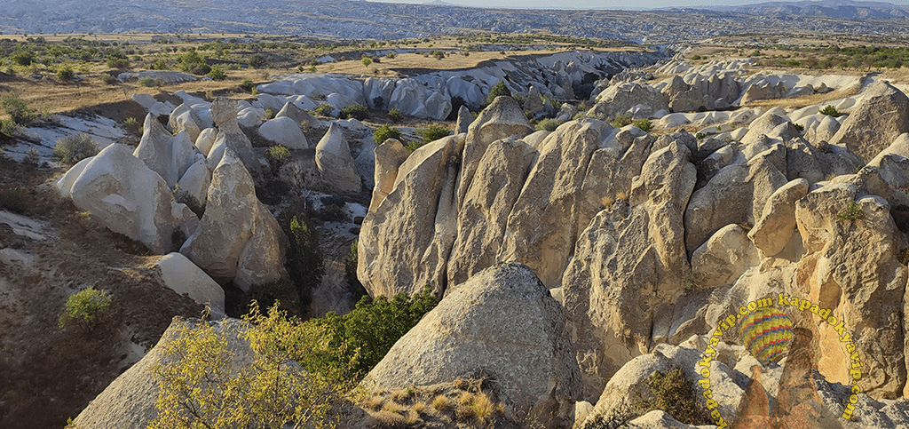
Gomeda Valley is located approximately two kilometers southwest of the village of Mustafapaşa in the district of Ürgüp, Nevşehir province, Türkiye. Geographically situated west of Mustafapaşa and north of Ayvalı Village, the valley is one of the most distinctive geomorphological areas within the Cappadocia region. Historically known as “Kanavuria” by the Greeks, the valley has been identified as one of the ravines of Elevres.
Gomeda Vadisi (Ürgüp Belediyesi)
The valley was shaped by erosion from rain, wind, and floodwaters acting upon the tuff formations typical of Cappadocia. With depths reaching up to 40 meters in places, it formed over time through the erosion of tuff layers deposited by volcanic activity from Erciyes, Hasan Dağı, and Göllüdağ volcanoes, which became active during the Tertiary period (approximately 60 million years ago). In addition to tuff, the valley contains various geological rock types including tuffite, ignimbritic tuff, lahar, volcanic ash, clay, sandstone, marl, agglomerate, and basalt.
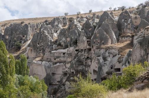
The Üzengi Stream flows through the valley, integrating water sources with the rock formations and vegetation along its course. One of the caves in the valley was constructed as a reservoir to collect rainwater and continues to serve as a water source for irrigating poplar trees within the valley. Pigeon houses dating from antiquity and niches containing dovecotes in the rock faces indicate the region’s ecological diversity.

Gomeda Vadisi (Anadolu Ajansı)
Gomeda Valley has been a site of intensive settlement throughout history. According to tradition, a village of six hundred households once existed here. Rock-cut shelters, underground cities, and places of worship within the valley reflect this historical habitation. Near the entrance to the valley, the church known as “Alakara” and officially named Timios Stavros Church is among the region’s most significant historical structures. Dated to the Byzantine period, the church derives its name from the Greek term meaning “Holy Cross.” According to one account, it was built by local residents during a campaign by a Byzantine emperor.
Another notable structure in the valley is the Church of Saint Basilios, dated to the 9th century. It was constructed in honor of Saint Basilios, one of the Cappadocian Fathers. Another church dedicated to the same saint is located in Beydere.
Churches from the Byzantine period also exist in surrounding areas. The Ladder Church (9th century) in Derindere Valley to the south of Gomeda Valley, and the Hacı İsmail Dere Churches (10th century) located in the area known as “Virgin Mary Valley” or Kara/Karae, demonstrate the continuity of the region’s historical and religious architecture. All these structures feature frescoed wall paintings that exemplify Byzantine art in the region.
The natural and historical structures within the valley provide insights into the lifestyle of its former inhabitants. Rock-cut dwellings and pigeon houses reveal a way of life deeply integrated with the natural environment. One of the most prominent examples is the Stavropulos family, who lived in rock dwellings around Timios Stavros Church and later settled in Sinasos, adopting the church’s name as their surname.
Anadolu Ajansı. “Kapadokya'nın Gözbebeği Ürgüp'teki Gomeda Vadisi Doğa Tutkunlarını Ağırlıyor.” Accessed May 15, 2025.https://www.aa.com.tr/tr/pg/foto-galeri/kapadokyanin-gozbebegi-urgupteki-gomeda-vadisi-doga-tutkunlarini-agirliyor/146
Kara, Recep. “Gomeda Vadisi (Kapadokya/Nevşehir) Epilitik Briyofit Vejetasyonu.” *Anatolian Bryology* 6, no. 2 (2024). Accessed May 15, 2025.
Ürgüp Belediyesi. “Gomeda Vadisi.” Ürgüp Municipality. Accessed May 15, 2025.https://urgup.bel.tr/tr/sosyal-tesis/gomeda-vadisi

Location | Nevşehir - Ürgüp | ||||||||
|---|---|---|---|---|---|---|---|---|---|
Ancient Name | Kanavuria (Rum Settlement) | ||||||||
Historical Structures | Alakara (Timios Stavros) Church (10th–19th centuries), Church of Saint Basilios (9th century), Ladder Church (9th century), Hacı İsmail Dere Churches (10th century) | ||||||||
Natural Features | Volcanic Tuff Formations, Üzengi Stream, Rock-Cut Structures, Dovecotes, Rainwater Cisterns | ||||||||
Ecological Feature | Rich Epilithic Bryophyte (Moss) Species Diversity | ||||||||
Geological Formation
Natural Structure and Ecology
Historical and Cultural Heritage
Valley Culture and Settlement