


This article was automatically translated from the original Turkish version.
+1 More
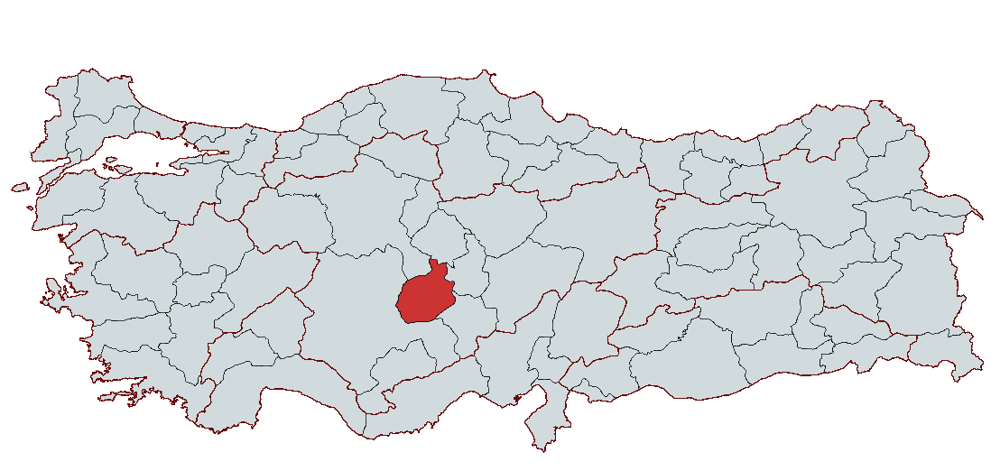
Aksaray
Country | Türkiye | ||||||||
|---|---|---|---|---|---|---|---|---|---|
Region | Central Anatolia Region | ||||||||
Population | 439474 | ||||||||
Area | 7997 km² | ||||||||
Climate | Continental Climate | ||||||||
Important Structure | Saratlı Kırkgöz Underground City Aşıklı Höyük Saint Marcuries Underground City | ||||||||
Area Code(s) | 382 | ||||||||
License Plate Code | 68 | ||||||||
Governor | Mehmet Ali Kumbuzoğlu | ||||||||
Mayor | Dr. Evren Dinçer | ||||||||
Aksaray is a province located in the Central Anatolia Region of Türkiye, notable for its historical depth and geographic position. With settlement traces extending back to 7000–6000 BCE, Aksaray has been influenced by various civilizations since antiquity and has served as an important cultural and trade center throughout its history. The region has been continuously inhabited since the Neolithic period and bears traces of numerous civilizations including the Assyrians, Hittites, Phrygians, Romans, Byzantines, Seljuks, and Ottomans. Today, Aksaray draws attention for its economic activities, primarily agriculture and livestock, while also offering a rich cultural past through its natural and historical heritage. Significant archaeological sites such as Aşıklı Höyük, Ihlara Valley, and the Underground City of Saint Macarius provide important insights into the region’s history.
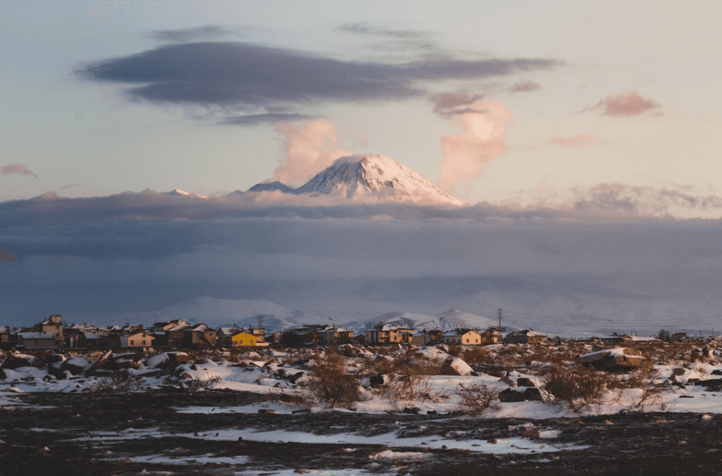
Aksaray (Source: Pexels/Mehmet Yasin Kabaklı)
Aksaray’s history extends back to 7000–6000 BCE. Archaeological evidence of human habitation has been found within the current boundaries of Aksaray during the Neolithic Age. A painting depicting lava flows from Mount Hasan discovered at Çatalhöyük highlights the region’s historical significance. During the Neolithic period, Aksaray and its surroundings were settled, and artifacts from the Chalcolithic and Early Iron Ages have also been uncovered. With the arrival of Assyrian merchants trading from Mesopotamia to Anatolia, Aksaray began to emerge as an important trade center.
Between 2000 and 1700 BCE, Assyrian colonies established trade networks in settlements around Aksaray. During this period, particularly due to the spread of writing and Assyrian merchant influence, Aksaray became a significant cultural center. The Hittites, who dominated the region between 1750 and 1200 BCE, incorporated Aksaray into their territory and left behind numerous important archaeological finds.
In the 8th century BCE, the Phrygians gained control over Aksaray and its surroundings, exerting a major cultural influence. The Phrygian capital was Gordion, and traces of Phrygian culture have been found in Aksaray. The Cimmerians invaded the region in the 7th century BCE following the decline of the Phrygians, bringing significant changes to Aksaray’s social and economic structure. After the fall of the Cimmerians, the Lydians seized Aksaray and engaged in conflict with the Persians in the 6th century BCE.
Aksaray became part of the Persian Empire’s satrapy of Cappadocia. The Persians administered the region through satrapies, and the Kingdom of Cappadocia, established in the 4th century BCE, incorporated Aksaray into its territory. One of the most important structures from this period is the King’s Road in Aksaray. After the victory of the Macedonian Kingdom under Alexander the Great, which ended Persian dominance, Aksaray came under Roman rule.
Following the Roman Empire, Aksaray and its surroundings came under Byzantine control. The Byzantine era marked the period when Christianity was introduced to Aksaray, churches were constructed, and the Eastern Roman Empire was reorganized. During this time, Aksaray gained importance as one of the region’s religious centers, with churches and monasteries established to spread Christianity. At the same time, the region suffered various military attacks and engaged in major conflicts with external powers such as the Sassanids and Arabs.
After the 1071 Battle of Manzikert, Aksaray was conquered by the Seljuk Turks. The Seljuks transformed Aksaray into one of Anatolia’s major cities, constructing numerous mosques, madrasas, and caravanserais. Sultanhanı, one of the most important structures of the Seljuk period, belongs to Aksaray. The Ottomans captured Aksaray in the 14th century and incorporated the territory into their domain. The Ottoman period was marked by the construction of numerous buildings, the growth of trade, and Aksaray’s emergence as a major economic center.
After the proclamation of the Republic, Aksaray was initially administered as a district subordinate to Konya, became a province in 1920, but was again attached to Niğde in 1933. In 1989, it regained its status as a province. Today, Aksaray is one of Türkiye’s important cities, showing significant development in industry, agriculture, and culture.
Aksaray is located in the central section of the Kızılırmak River in the Central Anatolia Region, in an area where the northern and southern Anatolian mountain ranges diverge. The province, with an elevation of 980 meters, covers a vast area of 7,997 km². It borders Kırşehir and Ankara to the north, Nevşehir to the east, Niğde to the southeast, and Konya to the west. Geographically situated between 37–38 degrees north latitude and 33–35 degrees east longitude, Aksaray is a province of Central Anatolia and occupies a strategically important location.
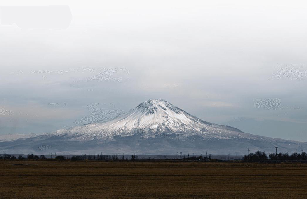
Aksaray (Source: Pexels/Hobi Photography)
Aksaray’s geological structure reflects the region’s historical volcanic activity. Shaped by volcanic movements during the Tertiary period, the area features a landscape composed of calcareous volcanic tuffs. Among the highest volcanic mountains in the region are Mount Hasan (3,268 m), Küçük Hasan Dağı (3,040 m), and Ekecik Dağı (2,033 m). Aksaray is characterized by volcanic plateaus surrounded by these mountains, flatlands formed by lava flows, and various folds. The province lies at the convergence of the Tuz Gölü basin and the Central Kızılırmak plateau. This region gradually acquired its current form through geological processes over time.
Aksaray’s vegetation has developed in response to its continental climate. In spring, herbaceous plants such as meadow grasses, daisies, and keven thrive, but during the hot and dry summer months, these plants wither and the region transforms into a steppe landscape. Oak woodlands are found on Mount Hasan and Ekecik Dağı. Tree species such as cedar, black pine, acacia, and almond are also present. This vegetation contributes to maintaining Aksaray’s ecological balance and supports a rich flora.
Aksaray’s water resources consist of rivers fed by various fault and valley systems. The Melendiz Mountains give rise to the Uluırmak River, the region’s most important water source. Karasu and Eşmekaya streams are also significant rivers. Although Aksaray is relatively poor in water resources, underground water and artesian wells exist in certain areas.
Tuz Gölü, located within Aksaray’s provincial boundaries, is Türkiye’s second-largest lake and a vital water source. Approximately 400 km² of Tuz Gölü lies within Aksaray, and its shores are surrounded by marshlands. In addition, smaller freshwater reservoirs such as Kayı Gölü, Kartal Gölü, and Sarıgöl also contribute to Aksaray’s water resources.
Aksaray experiences a cold continental climate with hot, dry summers and cold, wet winters. Precipitation is concentrated especially in spring and winter. The temperature difference between summer and winter is considerable. Humidity levels drop during summer, while winter temperatures often fall below freezing, resulting in snowfall. In spring, snowmelt can cause flooding and soil erosion.
Aksaray’s soil structure is primarily composed of igneous, metamorphic, and continental sedimentary rocks. These soils include various types such as brown soils, calcareous brown soils, and alluvial soils. Particularly in the Aksaray Plain, alluvial soils cover a wide area and provide fertile land for agriculture. Alongside its vegetation, this fertile soil structure enables the development of agricultural activities in the region.
Aksaray’s economy is largely shaped by agriculture and livestock farming. Agriculture is one of the main sectors of Aksaray’s economy, with a significant portion of farmland dedicated to dryland crops. As of 2013, employment in the agricultural sector accounted for 42.2% of the province’s workforce. Dryland farming occupies 71% of agricultural land, while irrigated farming accounts for 29%. Aksaray has 420,430 hectares of agricultural land, the majority of which is devoted to crops such as wheat, barley, sugar beet, and forage plants.
Livestock farming is also a significant sector in Aksaray. According to 2013 data, the province has 220,864 head of large livestock and 408,862 head of small livestock. There are 22,104 plant production and 20,682 livestock operations registered in the province. Milk production, meat production, and small livestock farming play major roles in livestock activities. Aksaray is one of Türkiye’s key livestock regions, with the number of large livestock continuously increasing. Additionally, 174,223 head of large livestock and 506,126 head of small livestock are registered in the TÜRKVET system.
In addition to agriculture and livestock, the food processing and industrial sectors are also important in Aksaray. In 2014, there were 382 food production enterprises and 175 enterprises engaged in feed production and sales. Feed factories in the province are key industrial establishments supporting the continuity of agricultural production. These industries have an annual feed production capacity of 106,250 tons.
Moreover, agricultural support and incentive programs are implemented in Aksaray to provide economic benefits to local farmers. Farmers benefit from various support programs to increase productivity and gain access to new technologies. These supports include the use of certified seeds and seedlings, subsidies for diesel and fertilizer, and irrigation projects. Additionally, great importance is placed on projects aimed at improving agricultural infrastructure and land consolidation efforts.
Aksaray province occupies a strategic position at the intersection of major roads connecting the east and west, and the north and south of Türkiye. Its location on the E-90 highway significantly strengthens its transportation network. Aksaray lies almost at the center of major cities such as Konya, Kayseri, Adana, and Ankara. This location ensures direct road connections between Aksaray and both internal and external regions. The province’s highway network spans a total of 487 km, of which 206 km are divided highways. Additionally, there is a 2,182 km network of village roads. Aksaray lies along major transportation routes, with distances to key cities as follows: Aksaray-Ankara 225 km, Aksaray-Konya 148 km, Aksaray-Adana 265 km, Aksaray-Mersin 258 km, Aksaray-Istanbul 674 km, Aksaray-Izmir 692 km, Aksaray-Niğde 123 km, and Aksaray-Nevşehir 75 km.
Aksaray province lies on the Ulukışla-Yerköy freight railway line, and a 111 km railway project connecting Aksaray to Ulukışla is underway. This project is expected to enhance railway infrastructure and increase transportation capacity in the province. Additionally, the Kayseri-Antalya high-speed train project is planned to pass through Aksaray. These initiatives will accelerate regional connectivity and improve the efficiency of Aksaray’s railway transportation.
Aksaray’s air transport access is provided by the nearest airport, Nevşehir Kapadokya Airport, located 77 km away, which operates as an international airport. The distance to Mersin Port is 258 km. Alternative airports include Kayseri Erkilet Airport, 160 km away, and Konya Airport, 141 km away. However, Aksaray does not have its own airport within its provincial boundaries.
Aksaray’s population growth cannot be accurately traced before the first national census in 1927. Prior to this date, population data was uncertain due to frequent administrative changes and shifting boundaries. The first census in 1927 recorded Aksaray’s population at 127,224. However, Aksaray’s status as a district subordinate to Niğde until 1990 hindered accurate population monitoring. After 1990, population censuses revealed a continuous increase in population. The population rose from 326,399 in 1990 to 429,069 in 2021. In this period, 350,783 people lived in the provincial center and 78,286 in villages.
The gender distribution in Aksaray is balanced. Although female population exceeded male population in the 1927 census, this was due to male population losses during wartime and the requirements of military service or work during normal periods. According to the 2021 census, Aksaray’s population consists of 214,841 males and 214,228 females, indicating nearly equal gender distribution.
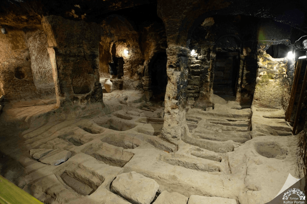
Saint Macarius Underground City (Source: Culture Portal)
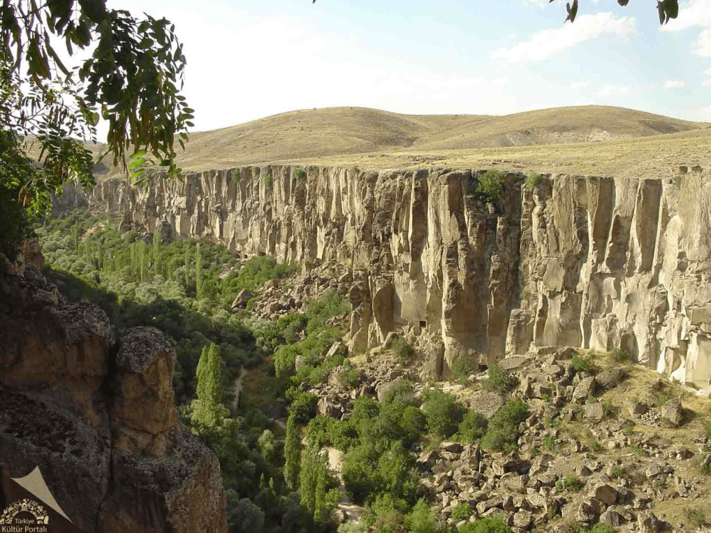
Ihlara Valley (Source: Culture Portal)
The governorship of Aksaray is currently held by Mehmet Ali Kumbuzoğlu , who was appointed as Governor of Aksaray by Presidential Decree No. 376 dated 10.08.2023.
Ahiler Kalkınma Ajansı. "Aksaray Ekonomi Göstergeleri." Accessed January 12, 2025.https://www.ahika.gov.tr/assets/upload/dosyalar/ahika_2017_aksaray-ekonomi-gostergeleri.pdf.
Aksaray Valiliği. "Aksaray Tanıtımı." Accessed January 12, 2025.http://www.aksaray.gov.tr/aksaray-tanitim#:~:text=Cumhuriyet%20d%C3%B6nemine%20kadar%20Konya'ya,Nenessa%20(Nenossos)%20oldu%C4%9Fu%20san%C4%B1lmaktad%C4%B1r.
Aksaray Valiliği. "Aksaray Valisi Mehmet Ali Kumbuzoğlu." Accessed January 12, 2025.http://www.aksaray.gov.tr/aksaray-valisi-mehmet-ali-kumbuzoglu.
Aksaray Çevre and Urbanization Provincial Directorate. "Tarihçe." Accessed January 12, 2025.https://aksaray.csb.gov.tr/tarihce-i-96424
Aksaray Çevre and Urbanization Provincial Directorate. "İlimiz Konumu." Accessed January 12, 2025.https://aksaray.csb.gov.tr/ilimiz-konumu-i-96425.
Aksaray İl Kültür ve Turizm Müdürlüğü. "Coğrafya." Accessed January 12, 2025.https://aksaray.ktb.gov.tr/TR-63622/cografya.html
Aksaray İl Kültür ve Turizm Müdürlüğü. "Cumhuriyet Dönemi ve Aksaray’ın Vilayet Oluşunun Tarihçesi." Accessed January 12, 2025.https://aksaray.ktb.gov.tr/TR-63620/cumhuriyet-donemi-ve-aksaray39in-vilayet-olusunun-tarih-.html.
Aksaray İl Kültür ve Turizm Müdürlüğü. "Müzeler ve Örenyerleri." Accessed January 12, 2025.https://aksaray.ktb.gov.tr/TR-63655/muzeler-ve-orenyerleri.html.
Aksaray İl Kültür ve Turizm Müdürlüğü. "Nüfus." Accessed January 12, 2025.https://aksaray.ktb.gov.tr/TR-243558/nufus.html.
Aksaray İl Kültür ve Turizm Müdürlüğü. "Tarihsel Gelişim." Accessed January 12, 2025.https://aksaray.ktb.gov.tr/TR-63607/tarihsel-gelisim.html.
Aksaray İl Kültür ve Turizm Müdürlüğü. "Ulaşım." Accessed January 12, 2025.https://aksaray.ktb.gov.tr/TR-243556/ulasim.html.
Aksaray İl Tarım ve Orman Müdürlüğü. "Faaliyet Raporu." Accessed January 12, 2025.https://aksaray.tarimorman.gov.tr/belgeler/faaliyet_raporu.pdf.
Invest in Aksaray. "Bir Bakışta Aksaray: Demografik Yapı." Accessed January 12, 2025.https://www.investinaksaray.com/bir-bakista-aksaray/demografik-yapi.
Turkish Museums. "Aksaray’da Görmeniz Gereken Yerler." Accessed January 12, 2025.https://www.turkishmuseums.com/blog/detail/aksaray-da-gormeniz-gereken-yerler/10095/1

Aksaray
Country | Türkiye | ||||||||
|---|---|---|---|---|---|---|---|---|---|
Region | Central Anatolia Region | ||||||||
Population | 439474 | ||||||||
Area | 7997 km² | ||||||||
Climate | Continental Climate | ||||||||
Important Structure | Saratlı Kırkgöz Underground City Aşıklı Höyük Saint Marcuries Underground City | ||||||||
Area Code(s) | 382 | ||||||||
License Plate Code | 68 | ||||||||
Governor | Mehmet Ali Kumbuzoğlu | ||||||||
Mayor | Dr. Evren Dinçer | ||||||||
History
Ancient Periods and the Hittite Era
Hittites and Subsequent Periods
Phrygians, Cimmerians, and Lydians
Persians and the Kingdom of Cappadocia
Roman and Byzantine Periods
Seljuks and Ottoman Period
Modern Period and the Republic
Geographical Structure
Geological Structure and Land Formation
Vegetation and Climate
Water Resources and Lakes
Climate Characteristics
Soil Structure
Economic Structure
Infrastructure
Highway Network
Railway
Air Transport and Port
Demographic Structure
Historical Structures
Administration
Governor