`geological-structure` Related Article Results

Levent Valley
Levent Valley is located in the Levent neighborhood within the Akçadağ district of Malatya Province in Türkiye’s Eastern Anatolia Region. It is situated approximately 45 kilometers from the city center of Malatya.Geological StructureThe valley features geological formations dated to approximately 65 million years ago. The area consists of a natural landscape characterized by rock formations caves and steep slopes. Levent Valley has a length of approximately 28 kilometers.Infrastructure and Facil
EN
Zelal Çakar

Çal Cave
The Çal Cave, located in the Düzköy district of Trabzon Province, is one of the karstic underground cavities of Black Sea Region. Its geological structure, internal water systems, and seasonal visitor density give it regional significance.Location and Elevation CharacteristicsThe cave is situated in Çal Village, part of the Düzköy district of Trabzon's, at an elevation of approximately 1,050 metres above sea level. It is about 50 kilometres from the city centre of Trabzon. Access is provided via
EN
Zeynep Şule Bingöl

Mariana Trench
The Mariana Trench is the deepest known oceanic point on Earth. It is located in the western Pacific Ocean, to the east of the Mariana Islands. With a depth of approximately 10,994 meters (Challenger Deep), it is recorded as the lowest point on the ocean floor. The trench is about 2,550 kilometers long and has an average width of 69 kilometers.Geological Structure and Formation ProcessThe Mariana Trench is the result of a subduction zone formed within the framework of oceanic tectonics, where th
EN
Sümeyye Akkanat Terzioğlu

Enceladus
Enceladus is one of Saturn’s natural satellites. Observations and analyses have suggested that this celestial body's icy surface may conceal an internal structure containing liquid water. Water vapor and ice particles ejected from the south polar region have revealed that Enceladus is a geologically active satellite, making it a focal point of scientific research.Physical and Orbital CharacteristicsEnceladus is among Saturn’s medium-sized moons. Its surface is largely covered by ice and exhibits
EN
Hediye Kocadeniz

Pink Rocks
Pembe Kayalar are located within the boundaries of the Kefken village, in the Kandıra district of Kocaeli province, in Türkiye’s Marmara Region. This natural formation lies on the Black Sea coast approximately one kilometre from the Kefken shoreline. Access to the area is typically provided via the routes from Kaynarca, Kumcağız, Kerpe and Kefken.Pembe Kayalar.(Ministry of Culture and Tourism of Türkiye)" image-alternate="" image-element-format="right">Geological FeaturesPembe Kayalar derive
EN
Bilge Öztürk

Kısık Canyon
Kısık Canyon is a natural canyon located within the boundaries of the Bekilli district in Denizli Province, Türkiye. The region holds significance due to its geological structure, biological diversity, and tourism potential.Geographical FeaturesThe canyon is situated in the western sections of the Taurus Mountains, near Kısık Village under the administration of Bekilli. Geologically, the canyon is dominated by limestone and calcareous formations and is among the most significant canyons in the r
ENZeynep Şule Bingöl

Homa GümüşSu Waterfall
Gümüşsu Homa Waterfall is a natural water formation located within the boundaries of Çivril district, Denizli province. The region’s geological structure and climatic conditions have influenced the formation of the waterfall, and diverse vegetation cover and biological diversity are observed in its surroundings. Historically, archaeological findings support the evidence that the area has been inhabited for a long time. The area surrounding the waterfall offers an environment where natural and cu
EN
Fatma Köroğlu
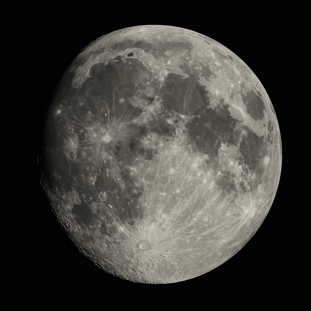
What is the cause of the dark regions on the Moon?
The Moon, when observed with the naked eye, is a celestial body with distinct color variations on its surface. These differences have been interpreted in various ways throughout history. In particular, the dark gray regions were once thought to be seas, while the lighter gray areas were believed to be continents. However, modern observations have revealed that this perception does not reflect the actual surface topography and geological structure.The reason some regions on the Moon appear darker
EN
Mehmet Bağcı

Kruber Cave
Krubera Cave is a subterranean formation known as the second deepest natural cave in the world and a significant contributor to speleological literature. It is located within the Arabika Massif in the Abkhazia region of northwestern Georgia. With a surveyed depth of 2,199 meters (±20 m), it held the title of “the deepest cave in the world” for many years. Its alternative name, Voronya Cave, means “crow cave” in Russian.Geographical Location and Geological StructureKrubera Cave is situated in the
EN
Mucip Aslan
 Ta
TaTarsus Waterfall
Tarsus Waterfall is a natural water formation located in the Tarsus district of Mersin Province, Türkiye. Situated approximately five kilometers from the center of Tarsus city in the Mediterranean Region, the waterfall lies on a tributary of the Berdan River. Due to the region’s typical Mediterranean climate, its surroundings are covered year-round by a diverse vegetation cover. With a height of approximately 15 meters, the waterfall, together with its natural environment, is also used as a recr
ENZeynep Şule Bingöl