


This article was automatically translated from the original Turkish version.
+1 More
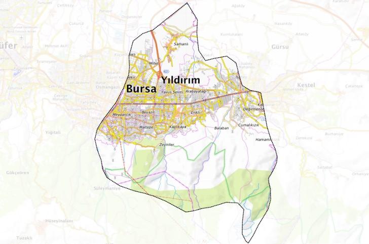
One of the central districts of Yıldırım, Bursa
Region | Marmara Region | ||||||||
|---|---|---|---|---|---|---|---|---|---|
District Governor | Metin Esen | ||||||||
Mayor | Oktay Yılmaz | ||||||||
Elevation | 150 m | ||||||||
Area | 399 km² | ||||||||
Postal Code | 16270 - 16360 | ||||||||
Telephone Code | 0224 | ||||||||
Yıldırım is one of the central administrative units of Bursa province. The district is located along the eastern axis of the Bursa metropolitan area. Yıldırım features an urban structure where industry, commerce and residential areas interact.
Introduction to Yıldırım District (Yıldırım Subgovernorship)
The historical origins of Yıldırım extend back to the Chalcolithic period, as evidenced by archaeological findings. Subsequently, the region came under the administration of the Kingdom of Bithynia, the Roman Empire and the Byzantine Empire, before falling under Ottoman rule in 1326. During the Ottoman period, Yıldırım became a strategic settlement center and derived its name from Ottoman Sultan Yıldırım Bayezid. Significant structures were built in the area as part of Sultan Bayezid’s development initiatives in Bursa, with the Yıldırım Bayezid Külliyesi being one of the most notable monuments of this era. Following the foundation of the Republic of Türkiye, Yıldırım experienced significant demographic and economic growth alongside the urban expansion of Bursa, and was granted the status of a central district in 1987.
Yıldırım district lies to the east of the city center of Bursa, on the northern slopes of Uludağ. The district borders Gürsu and Kestel districts to the north, Kestel district to the east, Uludağ to the south, and Osmangazi district to the west. The topography of Yıldırım is heterogeneous, shaped by various streams and valleys originating from Uludağ. There is no prominent river network within the district boundaries. However, the forested areas and natural landscapes on the slopes of Uludağ constitute important geographical features of the district.
The climate of Yıldırım district is transitional between Mediterranean and Black Sea climate types. This results in hot and dry summers and mild, rainy winters. In the higher elevation areas of the southern part of the district, influenced by Uludağ, lower temperatures and snowfall are recorded during winter months. The annual average temperature ranges approximately between 14 and 15 °C.
As of 2024, the population of Yıldırım district is recorded at 654,998. This figure confirms the district’s high population density within the Bursa metropolitan area. Analysis of population changes over time reveals a 0.9 percent increase compared to the previous year. Yıldırım continues to be one of Bursa’s key demographic centers.
Yıldırım district plays a significant role in the economic structure of Bursa province. Industry, trade and services are well developed in the district. Numerous enterprises operate in manufacturing sectors such as textiles, automotive ancillary industries, machinery and metalworking. Industrial zones within the district boundaries constitute a major source of employment. Commercial activities are concentrated especially in the district center. Various business centers, retail outlets and traditional markets contribute significantly to the local economy. In the service sector, institutions operate in education, healthcare, transportation and accommodation. The geographical proximity to Uludağ has indirect effects on the tourism sector of the district’s economy.
Yıldırım district attracts attention through its historical and cultural heritage. The Yıldırım Bayezid Külliyesi, an important complex from the Ottoman period comprising a mosque, madrasa, bathhouse, hospital and public kitchen, is one of the district’s symbolic structures. Other significant historical buildings within the district boundaries include the Emir Sultan Külliyesi and the Yeşil Türbe. The district’s proximity to Uludağ offers potential for winter tourism. During summer months, the natural beauty and highland meadows of Uludağ provide suitable environments for recreational activities.
The culinary culture of Yıldırım reflects the broader gastronomic characteristics of Bursa. Regional delicacies such as İskender kebab, pideli köfte, cantık and chestnut candy are served in various restaurants in the district. In addition, influences from Balkan and Caucasian migrants have introduced diverse flavors to the local cuisine.
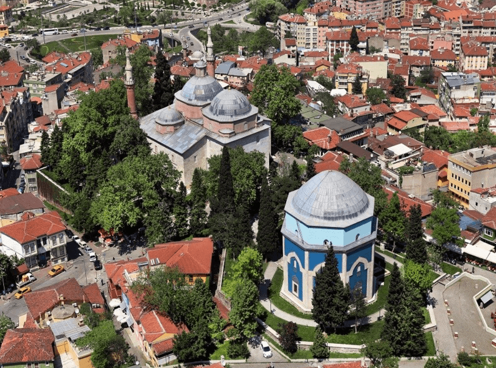
Yeşil Türbe (Yıldırım Kaymakamlığı)
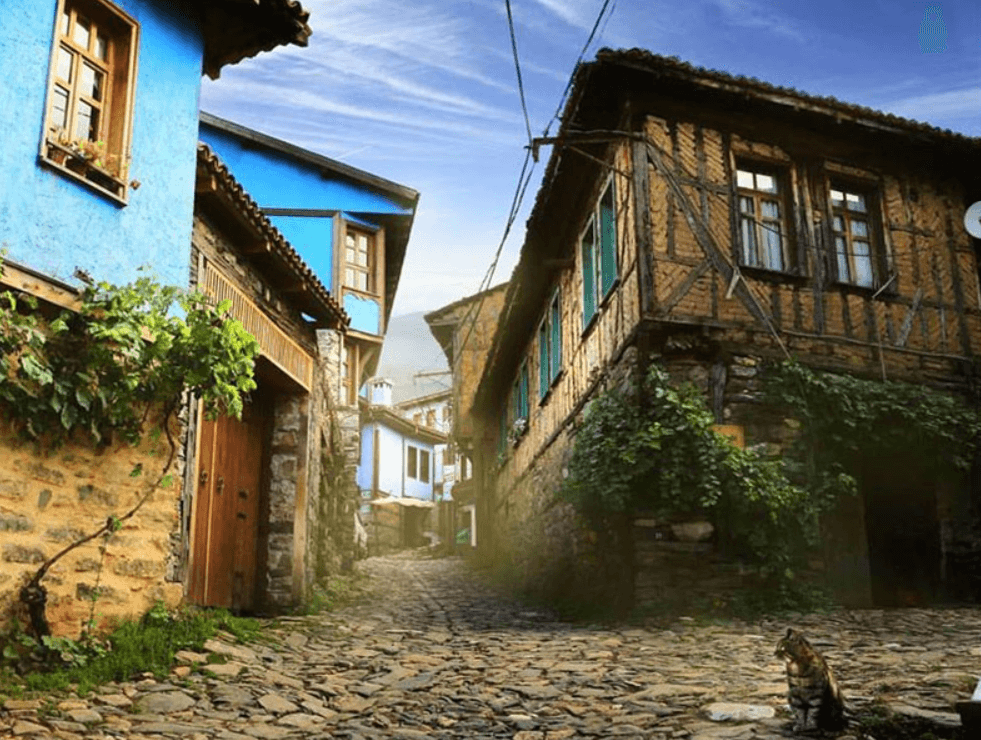
Cumalıkızık (Yıldırım Kaymakamlığı)
Bursa Valiliği. "Yıldırım." Accessed April 27, 2025.http://www.bursa.gov.tr/yildirim.
Paintmaps. "Paintmaps Örnek Yıldırım haritaları." Accessed April 27, 2025.https://tools.paintmaps.com/tr/harita-kirpma/TR/4-890463215/ornekler#google_vignette.
T.C. Yıldırım Kaymakamlığı. "YILDIRIM İLÇESİ TANITIM VİDEOSU." Accessed April 27, 2025.http://www.yildirim.gov.tr/yildirim-ilcesi-tanitim-videosu.
T.C. Yıldırım Kaymakamlığı. "Yıldırım Hakkında." T.C. Yıldırım Kaymakamlığı. Accessed April 27, 2025.http://www.yildirim.gov.tr/yildirim-hakkinda.
T.C. Yıldırım Kaymakamlığı. "Yıldırım Kültür." Accessed April 27, 2025.http://www.yildirim.gov.tr/kultur.
T.C. Yıldırım Kaymakamlığı. "Yıldırım Tarih." T.C. Yıldırım Kaymakamlığı. Accessed April 27, 2025.http://www.yildirim.gov.tr/tarih.
Türkiye Statistical Institute. "Türkiye İstatistik Kurumu (TÜİK)." Accessed April 27, 2025.https://www.tuik.gov.tr/
Türkiye İstatistik Kurumu. "Coğrafi İstatistik Portalı." Accessed April 27, 2025.https://cip.tuik.gov.tr/.
Yıldırım Belediyesi. "Yıldırım Belediyesi." Accessed April 27, 2025.https://www.yildirim.bel.tr/.
One of the central districts of Yıldırım, Bursa
Region | Marmara Region | ||||||||
|---|---|---|---|---|---|---|---|---|---|
District Governor | Metin Esen | ||||||||
Mayor | Oktay Yılmaz | ||||||||
Elevation | 150 m | ||||||||
Area | 399 km² | ||||||||
Postal Code | 16270 - 16360 | ||||||||
Telephone Code | 0224 | ||||||||
No Discussion Added Yet
Start discussion for "Yıldırım (District)" article
Historical Development
Geographical Location
Climate
Population and Demographic Structure
Economic Activities
Tourism, Culture and Cuisine