


This article was automatically translated from the original Turkish version.
Active Fault Map of Türkiye is the official geological map that shows the location, length, orientation, segment structure, and activity characteristics of active faults within the borders of Türkiye that have generated earthquakes in the geological past and have the potential to generate earthquakes in the future. The map aims to present the current scientific understanding of Türkiye’s active tectonic structure and serves as a fundamental reference for earthquake hazard analysis, disaster risk reduction, critical infrastructure planning, urban transformation projects, and land use decisions. Due to Türkiye’s location on the Alpine-Himalayan orogenic belt, which subjects it to high earthquake hazard, the regular mapping and updating of active faults is essential. The General Directorate of Mining Research and Exploration (MTA) shared the new version of the Active Fault Map of Türkiye on 22 June 2026, thirteen years after the previous edition.
Established in 1935, the MTA General Directorate is celebrating its 91st anniversary as of 2026.【1】 The institution responsible for research and mapping activities in the earth sciences in Türkiye, according to MTA General Director Vedat Yanık, is not merely an exploration organization but also an earth sciences research body. Active fault mapping constitutes one of the core components of this institutional function. Digital active fault maps at a scale of 1:25,000 are presented through a dedicated listing and access system within MTA’s service portfolio.【2】
The project for the Active Fault Map of Türkiye 2026 update was included in the investment program in 2022 and completed through evaluation of data obtained from fieldwork and academic research.【3】 The number of active faults recorded in the 2013 edition was 485; this has increased to 700 in the 2026 version.

Maden Tetkik ve Arama (MTA) Genel Müdürü Vedat Yanık (Anadolu Ajansı)
The map was officially announced on 22 June 2026 as part of the promotion program held within the framework of MTA’s Scientific Events Week and the institution’s 91st anniversary. The event planned 48 oral presentations and 20 poster sessions, aiming to connect the results of institutional projects with representatives from academia, public institutions, and industry.【4】
Türkiye’s position within the Alpine-Himalayan orogenic belt makes it imperative to update the depiction of its active tectonic structure with current data for national security, sustainable development, and disaster risk reduction. MTA General Director Yanık noted that the digital database prepared alongside the map is expected to serve as a reference source for earthquake hazard analysis, critical infrastructure investments, and damage mitigation policies.【5】
The Türkiye Earthquake Hazard Map was published in the Official Gazette on 18 March 2018 and entered into force on 1 January 2019. The project was supported under the National Earthquake Research Program (UDAP) within AFAD and received contributions from the Natural Disaster Insurance Institution (DASK). The Türkiye Building Earthquake Regulation was also published in the same Official Gazette and came into effect simultaneously.【6】
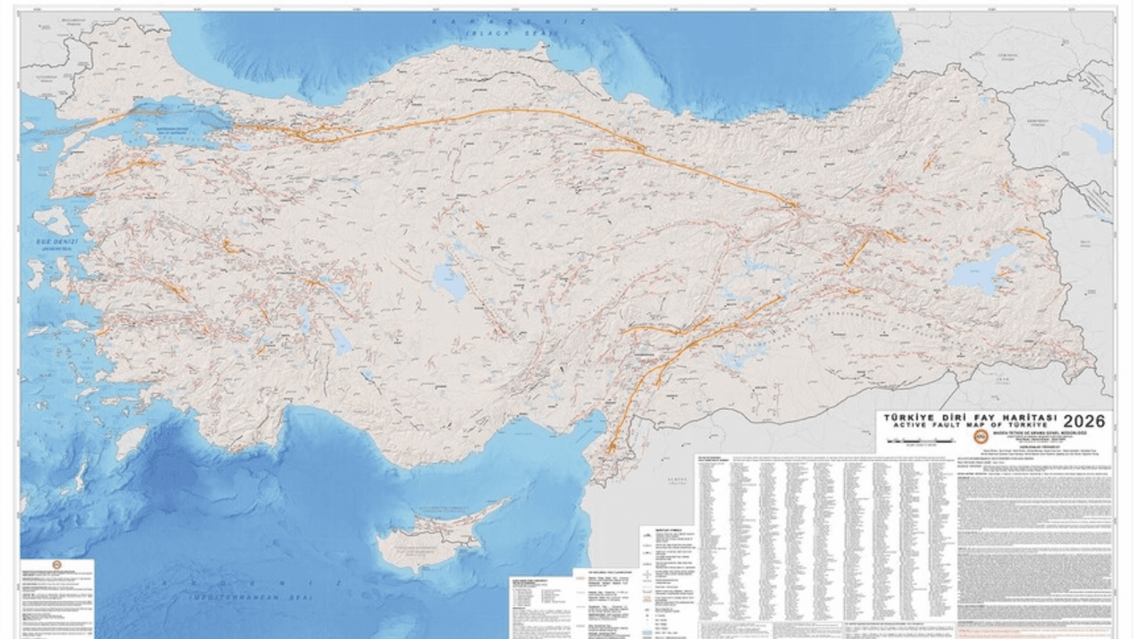
Türkiye Diri Fay Haritası (Anadolu Ajansı)
MTA’s Active Fault Map 2026 forms the geological input layer for the aforementioned hazard map. The fault map provides the geological record, while the hazard map represents the probabilistic and engineering interpretation of that record. When evaluated together with AFAD’s interactive Türkiye Earthquake Hazard Map, the active fault map is intended to serve as the foundational layer of an integrated risk assessment infrastructure for public institutions, local administrations, and the engineering sector.【7】
MTA General Director Yanık stated that increasing energy demand, resource management, climate change, and competition for raw materials have enhanced the strategic importance of earth sciences. In this context, the Active Fault Map of Türkiye 2026 also serves functions related to infrastructure route planning, urban transformation decisions, and land use policies, in addition to earthquake risk assessment.
Anadolu Ajansı. "MTA'nın 'Türkiye Diri Fay Haritası' 13 yıl sonra güncellendi." June 22, 2026. Accessed June 23, 2026. https://www.aa.com.tr/tr/bilim-teknoloji/mtanin-turkiye-diri-fay-haritasi-13-yil-sonra-guncellendi/3974123
Maden Tetkik ve Arama Genel Müdürlüğü. "Yenilenmiş Diri Fay Haritaları." Accessed June 23, 2026. https://www.mta.gov.tr/v3.0/hizmetler/yenilenmis-diri-fay-haritalari
T.C. Ministry of Interior, Directorate General of Disaster and Emergency Management. "Türkiye Deprem Tehlike Haritası." Accessed June 23, 2026. https://www.afad.gov.tr/turkiye-deprem-tehlike-haritasi
[1]
Maden Tetkik ve Arama Genel Müdürlüğü, "Yenilenmiş Diri Fay Haritaları," erişim tarihi 23 Haziran 2026, https://www.mta.gov.tr/v3.0/hizmetler/yenilenmis-diri-fay-haritalari
[2]
Maden Tetkik ve Arama Genel Müdürlüğü, "Yenilenmiş Diri Fay Haritaları."
[3]
Anadolu Ajansı, "MTA'nın 'Türkiye Diri Fay Haritası' 13 yıl sonra güncellendi," 22 Haziran 2026, erişim tarihi 23 Haziran 2026, https://www.aa.com.tr/tr/bilim-teknoloji/mtanin-turkiye-diri-fay-haritasi-13-yil-sonra-guncellendi/3974123
[4]
Anadolu Ajansı, "MTA'nın 'Türkiye Diri Fay Haritası' 13 yıl sonra güncellendi."
[5]
Anadolu Ajansı, "MTA'nın 'Türkiye Diri Fay Haritası' 13 yıl sonra güncellendi."
[6]
T.C. İçişleri Bakanlığı Afet ve Acil Durum Yönetimi Başkanlığı, "Türkiye Deprem Tehlike Haritası," erişim tarihi 23 Haziran 2026, https://www.afad.gov.tr/turkiye-deprem-tehlike-haritasi
[7]
T.C. İçişleri Bakanlığı Afet ve Acil Durum Yönetimi Başkanlığı, "Türkiye Deprem Tehlike Haritası."

No Discussion Added Yet
Start discussion for "Türkiye Active Fault Map (2026)" article
Institutional Background
The 2026 Update Process
Tectonic and Scientific Nature of the Map
Relationship with the Türkiye Earthquake Hazard Map
Policy and Infrastructure Dimension