


This article was automatically translated from the original Turkish version.
+1 More
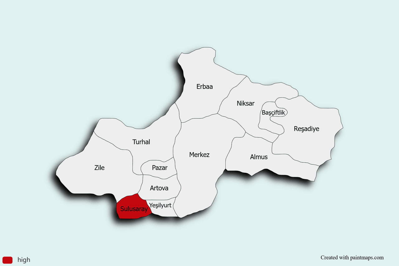
Sulusaray (District)
Province | Tokat | ||||||||
|---|---|---|---|---|---|---|---|---|---|
Region | Black Sea | ||||||||
Elevation | 1,222 m | ||||||||
Population (2024) | 6,880 | ||||||||
Mayor | Davut Kılıç | ||||||||
District Governor | Emre Arslan | ||||||||
Postal Code | 60870 | ||||||||
Climate | Continental climate | ||||||||
Economy | livestock farming and thermal tourism Agriculture | ||||||||
Sulusaray is a district located in the southwest of Tokat Province. It gained district status in 1990. Agriculture and livestock farming are the primary sources of livelihood in the district. Additionally, the developing tourism sector, thanks to thermal springs, contributes to the regional economy.
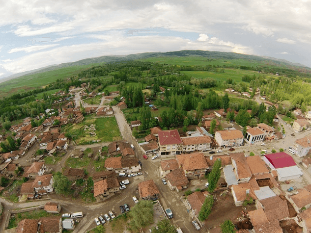
Sulusaray (Tokat İl Kültür ve Turizm Müdürlüğü)
The historical identity of Sulusaray is rooted in the ancient city of Sebastapolis (from Latin “Sebasto” – great, “polis” – city), established in antiquity. Although the exact founding date of the ancient city remains uncertain, some sources date it to the 1st century BCE. During the reign of the Roman Emperor Trajan (98–117 CE), it was detached from the provinces of Pontus Galaticus and Polemoniacus and incorporated into the province of Cappadocia. Inscriptions from Trajan’s era were erected in the name of the Cappadocian governor Arrian. Some sources indicate that the city was previously known as Heracleopolis (“City of Heracles”), referencing Heracles as a symbol of strength and power in ancient mythology.
Archaeological excavations conducted on the mound upon which the Sulusaray district is built have revealed settlement layers from the Early Bronze Age (3rd millennium BCE), the Hittite period (2nd millennium BCE), and the Phrygian period (first half of the 1st millennium BCE). The ancient city was also inhabited during the Hellenistic, Roman, and Byzantine periods, as evidenced by remnants of walls, street layouts, baths, and churches.
Following the Battle of Manzikert in 1071, the region came under the control of the Danismendids and was incorporated into the borders of the Seljuk Sultanate in the early 12th century. During the decline of the Anatolian Seljuk State, it passed through the rule of the Ilkhanids, the Eretna Beylik, and Kadı Burhaneddin before being incorporated into Ottoman territory in 1392. In Ottoman tax registers, the settlement was recorded as “Sebastapolis” or “Sulusaray” and rose to the status of a subdistrict center in the late 19th century within the Ottoman administrative structure.
During the Republican period, on 20 May 1990, it was officially granted district status while previously being a village under the jurisdiction of Artova. The district’s name was changed to “Sulusaray,” referencing the hot spring sources that have persisted from the Roman, Byzantine, Seljuk, and Ottoman periods to the present day.
Sulusaray is a settlement situated at 40° N, 36° E, 69 km from the center of Tokat Province, 30 km from Artova, and 11 km from Yeşilyurt, at an elevation of 1,030 meters above sea level. The district is bordered by Artova to the north, Yeşilyurt to the east, Kadışehri of Yozgat to the west, and Yıldızeli of Sivas to the south. It lies on a plain alongside the Çekerek River. The district center and village settlements spread across alluvial flatlands at the base of the plain. Northern mountain ridges form narrow plateaus descending into the valley, composed of limestone and andesitic lava. The soil cover consists of alluvial sandy-loamy soils suitable for agriculture in the plain, and forested areas of oak, pine, and plane trees on elevated terrain. Sulusaray lies within the transition zone between the Black Sea climate and the continental climate of Central Anatolia. Winters are cold and snowy, while summers are hot and dry. According to a three-year meteorological average, annual precipitation ranges between 400 and 450 mm, distributed mainly in winter and spring. Summer rainfall reaches its lowest levels between June and August. Average temperatures range from –4 °C to 5 °C in January and 18 °C to 20 °C in July. The average relative humidity is 55 percent; prevailing winds blow from the northeast in winter and from the southwest in summer.
The population of Sulusaray district was 9,595 in 2007 and declined to 6,880 by 2024. The highest population recorded during this period was 9,863 in 2008, while the lowest was 6,533 in 2022. Population increases were observed between 2007–2008 (+268), 2014–2015 (+607), 2015–2016 (+168), 2018–2019 (+197), 2022–2023 (+165), and 2023–2024 (+182); decreases occurred in other years at varying rates. According to 2024 data, the population consists of 3,488 males (50.70 percent) and 3,392 females (49.30 percent).
Official data indicate that the Sulusaray economy is predominantly based on agriculture and livestock farming.
Wheat, barley, and legumes are cultivated in irrigated areas of the plain. Cereals such as rye and korunga are grown under dry farming conditions. The soil’s stony texture and low mineral content limit productivity. The Çekerek River near the Sulusaray Bridge provides irrigation through canal networks, enabling irrigated agriculture. Small-scale livestock farming is widespread in the region. The limited number of pasture areas restricts the amount of grazing land per animal. Small-scale dairy and meat production contributes to rural household economies.
There are no large-scale industrial facilities in the district. Agricultural production and trade are supported through agricultural cooperatives, agricultural credit cooperatives, and artisan guarantee cooperatives. The ancient city and spa facilities, which hold tourism potential, do not generate economic value due to inadequate operational conditions. The absence of social facilities, cultural centers, and modern accommodation options limits the development of the service sector. These conditions have tightened the labor market and contributed to outward migration.
•Sebastapolis Ancient City: Located on a mound at the district center, it is a multi-layered settlement encompassing Early Bronze, Hittite, Phrygian, Hellenistic, Roman, and Byzantine strata. Baths, churches, and artifacts uncovered during excavations and rescue digs are displayed in an open-air museum.
•Sulusaray Bridge: A multi-arched stone bridge spanning the Çekerek River, likely constructed during the Byzantine or Seljuk period, preserving traces of historical transportation routes.
•Çermik Önü–Ilıca Spa: A hot spring source emerging from within the ancient city ruins; the water is sodium chloride, sulfate, and bicarbonate-rich with a temperature range of 32 °C to 44.3 °C. The spa has been continuously used from Roman times through the Ottoman period.
Official publications state that the district lacks cinemas, bookstores, conference halls, social facilities, and similar cultural amenities. Cultural activities are limited to sports and entertainment. The inability to fully excavate the ancient city restricts its potential for historical tourism.
There is no official documentation on unique culinary practices of Sulusaray. The local population primarily consumes grain and legume-based dishes such as pastries, bulgur pilaf, legume soups, and dairy products. Reviving spa tourism could provide an opportunity to promote local regional products.
T. C. Ministry of Culture and TourismTokat İl Directorate of Culture and Tourism. "Sulusaray." Tokat Provincial Directorate of Culture and Tourism. Accessed May 5, 2025.https://tokat.ktb.gov.tr/TR-141058/sulusaray.html
T. C. Sulusaray Kaymakamlığı. "Sebastapolis Antik Kenti." Sulusaray Kaymakamlığı. Accessed May 5, 2025.http://www.sulusaray.gov.tr/sebastapolis-antik-kenti
T. C. Sulusaray Municipality. "Hakkımızda." Sulusaray Belediyesi. Accessed May 5, 2025.https://tokatsulusaray.bel.tr/Hakk%C4%B1m%C4%B1zda/
T. C. Tokat Valiliği. "Sulusaray." Tokat Valiliği. Accessed May 5, 2025.http://www.tokat.gov.tr/sulusaray
T. C.Sulusaray Kaymakamlığı Governorship. "Sosyo-Ekonomik Durum." Sulusaray District Governorship. Accessed May 5, 2025.http://www.sulusaray.gov.tr/sosyo-ekonomik-durum#:~:text=İlçemizin%20ekonomik%20olarak%20geçim%20kaynağı,sosyal%20ve%20kültürel%20faaliyetler%20yapılamamaktadır
T. C.Sulusaray Kaymakamlığı Governorship. "Sulusaray Köprüsü." Sulusaray District Governorship. Accessed May 5, 2025.http://www.sulusaray.gov.tr/sulusaray-koprusu
T. C.Sulusaray Kaymakamlığı Governorship. "Sulusaray Tarihi." Sulusaray District Governorship. Accessed May 5, 2025.http://www.sulusaray.gov.tr/sulusaray-tarihi
Turkiye Statistical Institute (TÜİK). Address-Based Population Registration System Results, 2024. Accessed April 20, 2025.https://data.tuik.gov.tr/Bulten/Index?p=Adrese-Dayali-Nufus-Kayit-Sistemi-Sonuclari-2024-53783

Sulusaray (District)
Province | Tokat | ||||||||
|---|---|---|---|---|---|---|---|---|---|
Region | Black Sea | ||||||||
Elevation | 1,222 m | ||||||||
Population (2024) | 6,880 | ||||||||
Mayor | Davut Kılıç | ||||||||
District Governor | Emre Arslan | ||||||||
Postal Code | 60870 | ||||||||
Climate | Continental climate | ||||||||
Economy | livestock farming and thermal tourism Agriculture | ||||||||
No Discussion Added Yet
Start discussion for "Sulusaray (District)" article
History
Geography and Climate
Population and Demographics
Economy
Tourism, Culture, and Cuisine
Tourism and Cultural Assets
Cultural Infrastructure
Cuisine