+1 More
Şiran (District)
Mayor(s) | Abdulbaki Kara | ||||||||
|---|---|---|---|---|---|---|---|---|---|
Area(s)(Text) | 965 km² | ||||||||
Climate(s) | Continental climate harsh winters – hot summers | ||||||||
Province(s) | Gumushane | ||||||||
District Governor | Mehmet Alperen Baskapan | ||||||||
Featured Places | Asarcık Plateau Kulaca Plateau Tomara Waterfall | ||||||||
Culture – Cuisine | Highland festivals walnut buns corn flour dishes yogurt soups | ||||||||
Population (2023) | Approximately 18,000 | ||||||||
Located west of Gümüşhane, the district of Şiran is a prominent settlement with its rich history, fertile valleys, and traditional lifestyle. Bordering the provinces of Trabzon, Giresun, and Bayburt, the district bears the traces of numerous civilizations throughout history. With a history of settlement dating back to ancient times, Şiran today embodies both rural and urban characteristics. Its location on one of the transportation routes connecting the Eastern Black Sea region to Central Anatolia has increased the district's importance.

Şiran ( Şiran Municipality )
Şiran's history dates back to the ancient Pontus Kingdom and the Roman Empire. The district's location has been along a line of routes throughout history, paving the way for diverse cultural interactions. Şiran, which remained under Byzantine rule in the Middle Ages, came under the influence of principalities from the 11th century onward. Known as "Karadere" during the Ottoman period, the settlement was elevated to sub-district status in the 19th century and to district status during the Republican era.
Şiran is located west of Gümüşhane, at the eastern end of the Kelkit Valley. The district's surface area is approximately 965 km². While mountainous and rugged, the district also boasts plains suitable for agriculture. Large and small streams connected to the Kelkit Stream support the district's resources. Şiran, where a continental climate prevails, experiences cold and harsh winters and hot and dry summers. This climate plays a significant role in shaping the district's agricultural production and vegetation.
As of 2023, the population of the Şiran district was approximately 18,000. The majority of the population lives in the central district and the surrounding villages. Migration, particularly among young people, has a significant impact, with an increasing trend toward leaving the city for education and employment. Rural neighborhoods have a relatively high proportion of elderly residents. However, the district experiences temporary population growth during the summer months due to the influx of expatriates returning to their hometowns.
The Şiran district's economy is primarily based on agriculture and animal husbandry. In addition to barley wheat, and potatoes, grown. Walnut and apple production are particularly prevalent. In animal husbandry, small and large livestock are prominent. In recent years, various cooperative initiatives and rural development projects have been implemented to support agricultural production. Small-scale businesses contribute to the economy with handmade dairy products and local food products.
Şiran, with its plateaus and historical ruins, has potential for cultural tourism. Tomara Waterfall, approximately 25 km from the district, is a areas. Furthermore, plateaus such as Asarcık and Kulaca host traditional highland migrations and summer festivals.
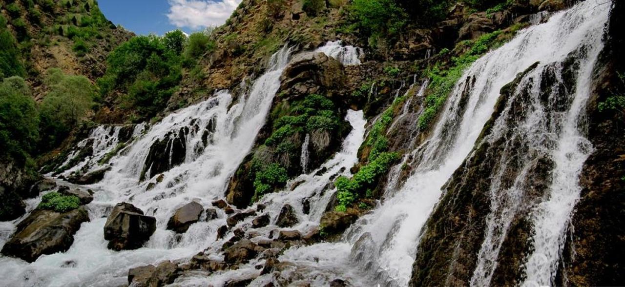
Şiran Tomara Waterfall ( Şiran Municipality )
Folk music, folk dances, and wedding traditions are important parts of the district's cultural heritage. Şiran cuisine is characterized by cornmeal dishes, meat-based kale, yogurt soups, and molasses production. Local walnut buns, in particular, hold a special cultural significance.
Gümüşhane Provincial Directorate of Culture and Tourism. “Şiran.” Republic of Turkey Ministry of Culture and Tourism. Accessed 16 April 2025. https://gumushane.ktb.gov.tr/TR-220831/siran.html
Paintmaps. “Turkey Provinces Map – Highlighting Şiran, Gumushane.” Access date: April 15, 2025. https://paintmaps.com
Şiran Municipality. “Şiran History.” TC Şiran Municipality Official Website. Accessed April 16, 2025. https://www.siran.bel.tr/sayfa/siran-tarihi
Şiran Municipality. “Geographical Structure.” TC Şiran Municipality Official Website. Accessed April 16, 2025. https://www.siran.bel.tr/sayfa/cografi-yapisi
Şiran Municipality. “Şiran Photos.” Şiran Municipality Official Website. Accessed April 15, 2025. https://siran.bel.tr/fotograflar/siran-fotograflari/2
TC Şiran District Governorship. "District Governorship." Accessed April 16, 2025. http://www.siran.gov.tr/kaymakam
Şiran (District)
Mayor(s) | Abdulbaki Kara | ||||||||
|---|---|---|---|---|---|---|---|---|---|
Area(s)(Text) | 965 km² | ||||||||
Climate(s) | Continental climate harsh winters – hot summers | ||||||||
Province(s) | Gumushane | ||||||||
District Governor | Mehmet Alperen Baskapan | ||||||||
Featured Places | Asarcık Plateau Kulaca Plateau Tomara Waterfall | ||||||||
Culture – Cuisine | Highland festivals walnut buns corn flour dishes yogurt soups | ||||||||
Population (2023) | Approximately 18,000 | ||||||||
History
Geography and Climate
Population and Demography
Economy
Tourism, Culture, and Cuisine
This article was created with the support of artificial intelligence.
