


This article was automatically translated from the original Turkish version.
+2 More
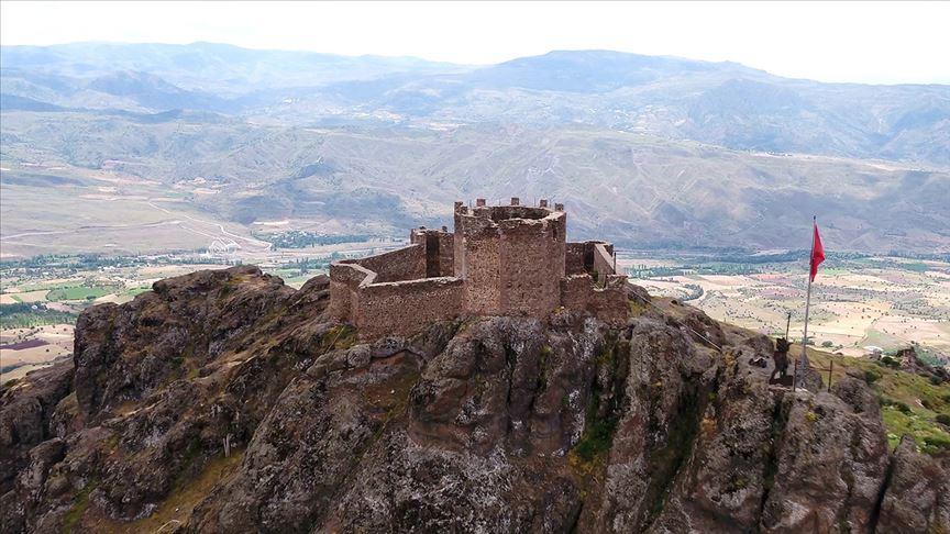
Şebinkarahisar Castle
Location | Şebinkarahisar Türkiye Giresun | ||||||||
|---|---|---|---|---|---|---|---|---|---|
Former Name | Koloneia Kalesi | ||||||||
Geographical Feature | It is built on a steep rocky outcrop that can control the Kelkit Valley. | ||||||||
Area | It covers an area of approximately 60,000 m². | ||||||||
Şebinkarahisar Kalesi is located approximately 90 km east of the city center of Giresun, at the northwestern edge of the Kelkit Basin. The castle is built on a rocky hill at an elevation of about 1200 meters. This location was chosen to control the surrounding valleys and passes. The region lies within the interior of Eastern Black Sea, connected to valleys leading to the Black Sea coast and extending to Samsun via the Kelkit Basin.
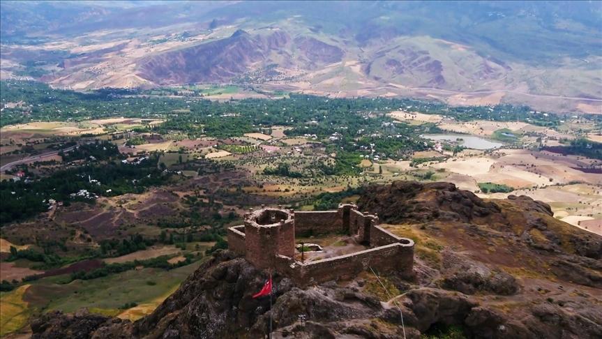
Şebinkarahisar Kalesi (Anadolu Ajansı)
The castle has been in use since antiquity. During the Byzantine Empire, it served as a strategic defensive point in border conflicts with the Sasanians, Umayyads, and Abbasids. It formed part of Byzantium’s eastern defense line in Anatolia. During this period, the castle was besieged and plundered multiple times.
Seljuk Turkish raids into Anatolia reached the vicinity of Şebinkarahisar from 1048 onward. The castle came under Seljuk control in 1058 but reverted briefly to Byzantine rule shortly thereafter. After the Battle of Manzikert in 1071, the castle came under Seljuk administration during the rule of the Mengujekids and later the Danişmendids from 1075.
With the Seljuks’ capture of the castle, the region opened to Turkish settlement. From 1080 onward, the area around the castle and the Kelkit Basin became centers of Turkish habitation. This process reflects the growth of the Turkish population in the Eastern Black Sea region.
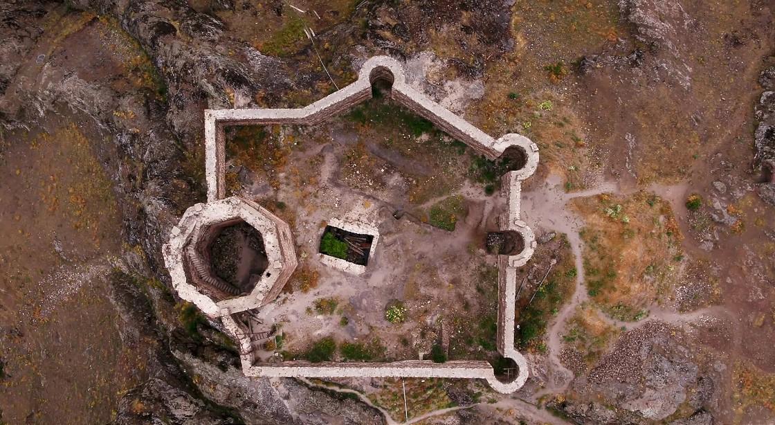
Şebinkarahisar Kalesi Üstten Görünüm (Anadolu Ajansı)
Natural stone was used in the construction of the castle. Cut stone and rubble stone were bound together with lime mortar. Some stone surfaces were finished. The mortar was made from a mixture of lime and sand.
The castle was built on a rocky terrain. Wall thicknesses vary according to defensive requirements. Towers were designed as tall and robust structures. Ramparts were constructed in accordance with the region’s climatic conditions and defensive needs.
Geometric patterns and relief motifs are found on some gateways and within the inner courtyard. Decorative techniques include surface carving and relief work.
The castle is surrounded by walls with bastions positioned at regular intervals. These bastions were constructed for defense and surveillance. Towers were designed to enhance resistance against sieges.
The castle entrances consist of narrow and easily defensible gates. Entrances are protected by two-way defensive systems. Gate passages feature covered structures.
Excavations and research have yielded examples of stonework, mortar remnants, and decorative elements. These findings contribute to the understanding of the castle’s architecture and the construction techniques of the period. Today, large sections of the castle are in ruins. Some parts remain intact and are under protection.
The area surrounding the castle was used as a settlement zone during the Seljuk and subsequent periods. The region served as a center for trade and cultural exchange and is among the earliest Turkish settlements in the Eastern Black Sea region.
Şebinkarahisar Kalesi (Giresun)
Danık, Ertuğrul. "Şebinkarahisar Kalesi." *Sanat Tarihi Dergisi* 13, no. 2 (2004): 51–78. Accessed May 31, 2025.https://dergipark.org.tr/en/download/article-file/152327
Giresun. "Şebinkarahisar Kalesi." YouTube. Accessed May 31, 2025.https://www.youtube.com/watch?v=6m7_dRKBPWU
Karadeniz Kültür Envanteri. "Şebinkarahisar Kalesi." Karadeniz Kültür Envanteri. Accessed May 31, 2025.https://karadeniz.gov.tr/sebinkarahisar-kalesi/
Sarıyıldız, Bekir. "ANADOLU’NUN FETHİ DÖNEMİNDE ŞEBİNKARAHİSAR KALESİ (1018-1081)." *Karadeniz Uluslararası Bilimsel Dergi* 1, no. 53 (2022): 156-166. Accessed May 31, 2025.https://dergipark.org.tr/en/pub/kdeniz/issue/68297/1067646
T.C. Ministry of Culture and Tourism. "Şebinkarahisar Kalesi." Giresun İl Kültür veTurizm Müdürlüğü Resmi Web Sitesi. Accessed May 31, 2025.https://giresun.ktb.gov.tr/TR-243493/sebinkarahisar-kalesi.html
Yetgin, Gültekin. "Doğası ve kültürel eserleriyle ön plana çıkan Şebinkarahisar, turizmde gelecek vadediyor." Anadolu Ajansı. Accessed May 31, 2025.https://www.aa.com.tr/tr/kultur-sanat/dogasi-ve-kulturel-eserleriyle-on-plana-cikan-sebinkarahisar-turizmde-gelecek-vadediyor/2367075
Yetgin, Gültekin. "Şehir, liman ve vadilerin koruyucusu kaleler halen ayakta." Anadolu Ajansı. Accessed May 31, 2025.https://www.aa.com.tr/tr/turkiye/sehir-liman-ve-vadilerin-koruyucusu-kaleler-halen-ayakta/1659816

Şebinkarahisar Castle
Location | Şebinkarahisar Türkiye Giresun | ||||||||
|---|---|---|---|---|---|---|---|---|---|
Former Name | Koloneia Kalesi | ||||||||
Geographical Feature | It is built on a steep rocky outcrop that can control the Kelkit Valley. | ||||||||
Area | It covers an area of approximately 60,000 m². | ||||||||
No Discussion Added Yet
Start discussion for "Şebinkarahisar Castle" article
Historical Development and Regional Significance
Ancient and Byzantine Periods
Transition to the Seljuk Period
Regional Turkish Settlement
Architectural Features and Construction Techniques
Building Materials
Construction Technique
Decoration and Stonework
Defensive Systems and Strategic Equipment
Walls and Bastions
Entrances and Passages
Archaeological Findings and Current Condition
Socio-Cultural Context of the Region