


This article was automatically translated from the original Turkish version.
+1 More
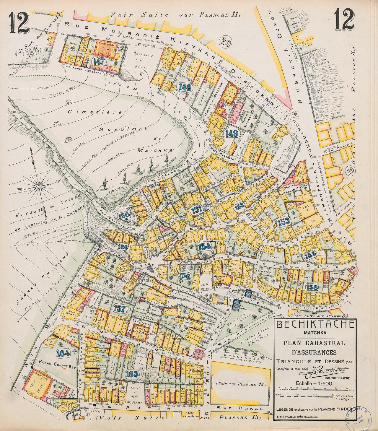
Pervititch Maps (Beşiktaş Insurance Plan No:12)
Prepared by | Jacques Pervititch | ||||||||
|---|---|---|---|---|---|---|---|---|---|
Number of Maps | Total of 243 maps | ||||||||
Preparation Period | 1922 – 1945 | ||||||||
Scale | Some at 1/4000 1/1000 1/5000 | ||||||||
Color Codes and Symbols | Yellow: Wooden structures Blue: Cisterns wells tiled roofs pools Yellow+Pink: Six-stone wooden structures brick and reinforced concrete structures Pink: Stone Green: Gardens and parks | ||||||||
Areas Covered | Galata Hereke Bafra İzmir Erenköy Moda Beşiktaş Şişli Kadıköy Üsküdar Beyazıt Fatih Eminönü Pera Tekirdağ (Rodosto) | ||||||||
Pervititch Maps are insurance maps created in the first half of the 20th century that meticulously document the urban fabric of Istanbul. Prepared by Croatian cartographer Jacques Pervititch between 1922 and 1945, these maps were originally commissioned by insurance companies to assess fire risks. Over time, however, they have become an invaluable source of information on Istanbul’s architectural structure, street layout, and social life.
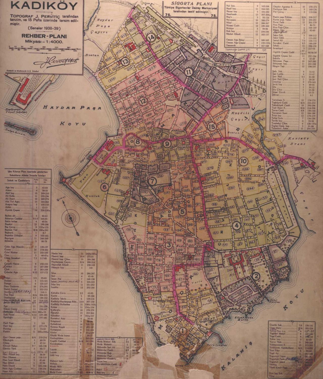
Kadıköy Rehber Planı (Salt Araştırma Arşivi)
The Pervititch maps are the product of a deliberate research effort aimed at identifying, evaluating, calculating, and ultimately mitigating long-term risks associated with the city’s built environment. The maps are highly detailed. For instance, on map number 76 covering Üsküdar, even the small hill formed by soil excavated during the construction of an electricity plant and garage opposite the cemetery is accurately depicted.
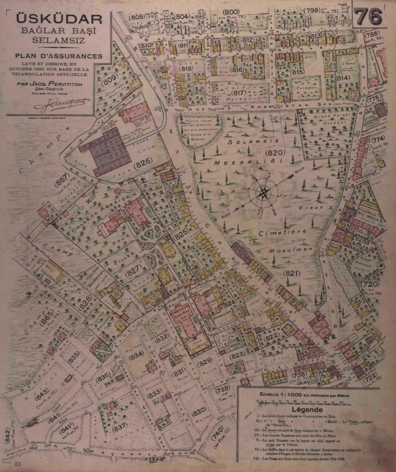
Insurance Plan No. 76, Üsküdar (Salt Araştırma Arşivi)
These maps record every detail that positively or negatively influences fire risk, including tobacco warehouses, factories, open-air cinemas, kiosks, gardens, vegetable plots, banks, schools, hospitals, police stations, pavilions, and various water structures. Even remnants of demolished buildings are marked. The maps also include detailed information on building materials and construction techniques for structures dating between 1920 and 1950, alongside physical environmental features such as wooded areas and beaches. Place names in use during the 1930s are consistently annotated on each map sheet.
It is possible to trace the paths of streets that no longer exist and neighborhoods whose names have changed through the Pervititch maps. In this context, the Pervititch maps constitute an important historical document that sheds light on their era. As primary sources documenting Istanbul’s architectural and cultural heritage—much of which has been severely damaged or lost over time—the Pervititch maps have become an essential component of scholarly research.
The Pervititch maps provide foundational infrastructure for identifying and transmitting Istanbul’s cultural and architectural heritage. Different building colors on the maps indicate building types within Istanbul’s architectural plan. Information on floor heights and topography is also included. They reveal the architectural heritage of Istanbul, which has been largely altered or nearly erased in the present day.
The fires of Aksaray in 1856 and Hocapaşa in 1865, and especially the extensive damage caused by the 1870 Pera fire—one of the city’s greatest disasters—marked a turning point in the development of fire insurance. Numerous companies began operating in Ottoman territories to offer fire insurance.【1】 The Ottoman insurance market was dominated from the 1870s onward by foreign insurance companies, particularly British ones.
At the end of the 19th century, Europeans who came to Istanbul for trade brought their own insurance systems with them; these institutions expanded by appointing agents for foreign nationals. The first indigenous insurance company in the Ottoman Empire was established during the reign of II. Abdülhamid under the name “Osmanlı Umum Sigorta Şirketi”.【2】 By 1910, Istanbul had 52 fire insurance companies; by 1922, this number had risen to 92 with the participation of companies capitalised by the United States, Poland, Hungary, Denmark and Australia. Additionally, two local companies—Constantinople (Istanbul) General Insurance Company and Türkiye Milli Sigorta Şirketi—were established during this period, and all insurance firms were brought under their umbrella.【3】
The increasing frequency and severity of fires made it essential for insurance companies to monitor regional risk levels. As a result, maps indicating fire risks based on the city’s built environment became vital tools for insurers. The first such maps, the Goad Maps, were prepared by British construction engineer C. E. Goad between 1904 and 1906 and covered only a limited portion of the city. Subsequent maps, commissioned by the Türkiye Sigortacılar Daire-i Merkeziyesi and created by Jacques Pervititch, were far more detailed and encompassed nearly all areas of Istanbul.【4】
The Pervititch maps are insurance maps funded by individual insurance companies, depicting fire risks at the cadastral parcel level. Although limited information exists about the life and identity of the maps’ creator, topographer and engineer Jacques Pervititch, much of what is known has been uncovered through the efforts of Müsemma Sabancıoğlu.
Jacques Pervititch was born around 1877 near Cavtat, south of Dubrovnik, within the present-day borders of the Republic of Croatia. He came from a Catholic family. His father, a seafarer, moved with his wife and children to Istanbul in 1880. Pervititch began his education at Saint Pierre Primary School and later continued his studies on scholarship at the French Saint Joseph High School. He graduated with distinction from Saint Joseph in 1894, though it remains unknown where he received his cartographic training. The year 1945, when he completed his final map, was also the year of his sudden death.【5】
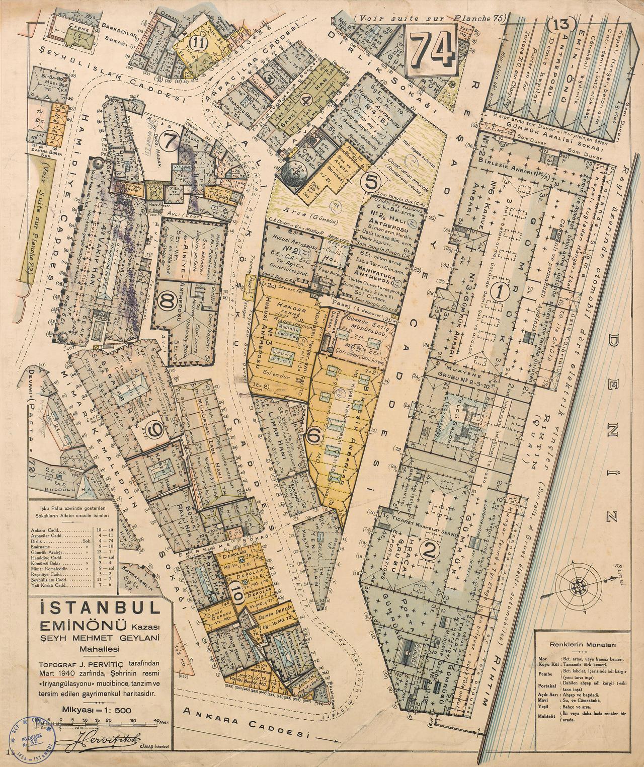
Insurance Plan No. 74, Eminönü (Salt Araştırma Arşivi)
The Pervititch Maps consist of a total of 243 sheets covering various neighborhoods of Istanbul. These 1:500 scale maps include details such as building materials (wooden or masonry), number of floors, usage purposes, and fire risk levels. Street names, significant structures, and green spaces are also clearly marked.
As primary source materials, the Pervititch maps are widely used in historical, urban planning, and architectural studies for their detailed documentation of early 20th-century street layouts. Although direct studies focused exclusively on the Pervititch maps are limited, the first scholarly efforts to compile and publish the complete collection began in the early 2000s through the joint initiatives of the History Foundation and Axa Oyak Insurance Company, spurred by Müsemma Sabancıoğlu’s research.
Following her research, Müsemma Sabancıoğlu published the book “Istanbul in Jacques Pervititch’s Insurance Maps,” which compiles over 200 maps created by Pervititch. The book includes comprehensive evaluations by İlhan Tekeli, Murat Güvenç, and Müsemma Sabancıoğlu, alongside a complete compilation of the surviving map sheets.
Following these three key articles on fire insurance and the Pervititch maps, the maps were organized by neighborhood. Istanbul’s districts—Beyazıt, Beyoğlu, Taksim, Eminönü, Fatih, Kadıköy, Şişli, and Üsküdar—were each introduced with a brief text before the corresponding map sheets were presented. Another major source used in this study is Müsemma Sabancıoğlu’s article “Jacques Pervititch and His Insurance Maps of Istanbul,” published in the Duvrovnik Journal. Additionally, an article on the Pervititch maps by Ayla Ödekan and Afife Batur appeared in the book supplement of Cumhuriyet Newspaper. Beyond these sources, no direct scholarly studies on Jacques Pervititch or his maps exist.
A large portion of the Pervititch Maps has been digitized and made accessible through the Salt Research Archive. Additionally, through a joint project by the History Foundation and Axa Oyak Insurance, the maps have been published in book form. The digitization and publication of these maps contribute significantly to the preservation of Istanbul’s historical and cultural heritage.
Güvenç, Murat. "Pervititch Haritaları: İstanbul için Bitmemiş Bir Araştırma Projesi." Jacques Pervititch Sigorta Haritalarında İstanbul, 14. Tarih Vakfı Yurt Yayınları, 1999.
Kılıç, Rabia. "Pervititch Haritaları Üzerinden Üsküdar Kent Dokusunda Çeşmeler." Master's thesis, Süleyman Demirel Üniversitesi, 2022.
Sabancıoğlu, Müsemma. "Jacques Pervititch and His Insurance Maps of Istanbul." Dubrovnik Annals 7 (2003): 89-98.
Salt Araştırma. "Sigorta Planı. Eminönü. Şeyh Mehmet Geylani. No: 74." Salt Research. Accessed May 13, 2025.https://archives.saltresearch.org/handle/123456789/93765
Salt Research. "Plan Cadastral d’assurances. Béchiktache. No: 12." Accessed May 13, 2025.https://archives.saltresearch.org/handle/123456789/126285
Salt Research. "Plan d'assurances. Üsküdar. Bağlarbaşı. Selamsız." Accessed May 13, 2025.https://archives.saltresearch.org/handle/123456789/93779
Salt Research. "Rehber planı. Kadıköy." Accessed May 13, 2025.https://archives.saltresearch.org/handle/123456789/121086
Tekeli, İlhan. "İnsanın Çevresini Bilme, Denetleme ve Yorumlama Aracı Olarak Haritalar." Jacques Pervititch Sigorta Haritalarında İstanbul, 9. Tarih Vakfı Yurt Yayınları, 1999.
Ödekan, Ayla. "Kent İçi Çeşme Tasarımında Tipolojik Çözümleme." Semavi Eyice Armağanı: İstanbul Yazıları, 281–297. İstanbul: Türkiye Turing ve Otomobil Kurumu Yayını, 1992.
Özger, Yunus. "Osmanlı’dan Cumhuriyet’e İlk Yerli Sigorta Şirketi." Uluslararası Sosyal Araştırmalar Dergisi 9, no. 47 (2016): 280.Accessed adresi
[1]
Ödekan, Ayla. "Kent İçi Çeşme Tasarımında Tipolojik Çözümleme." Semavi Eyice Armağanı: İstanbul Yazıları, 281–297. İstanbul: Türkiye Turing ve Otomobil Kurumu Yayını, 1992.
[2]
Özger, Yunus. "Osmanlı’dan Cumhuriyet’e İlk Yerli Sigorta Şirketi." Uluslararası Sosyal Araştırmalar Dergisi 9, no. 47 (2016): 280.
[3]
Güvenç, Murat. "Pervititch Haritaları: İstanbul için Bitmemiş Bir Araştırma Projesi." In Jacques Pervititch Sigorta Haritalarında İstanbul, 14. İstanbul: Tarih Vakfı Yurt Yayınları, 1999.
[4]
Tekeli, İlhan. "İnsanın Çevresini Bilme, Denetleme ve Yorumlama Aracı Olarak Haritalar." In Jacques Pervititch Sigorta Haritalarında İstanbul, 9. İstanbul: Tarih Vakfı Yurt Yayınları, 1999.
[5]
Sabancıoğlu, Müsemma. "Jacques Pervititch and His Insurance Maps of Istanbul." Dubrovnik Annals 7 (2003): 96–97.

Pervititch Maps (Beşiktaş Insurance Plan No:12)
Prepared by | Jacques Pervititch | ||||||||
|---|---|---|---|---|---|---|---|---|---|
Number of Maps | Total of 243 maps | ||||||||
Preparation Period | 1922 – 1945 | ||||||||
Scale | Some at 1/4000 1/1000 1/5000 | ||||||||
Color Codes and Symbols | Yellow: Wooden structures Blue: Cisterns wells tiled roofs pools Yellow+Pink: Six-stone wooden structures brick and reinforced concrete structures Pink: Stone Green: Gardens and parks | ||||||||
Areas Covered | Galata Hereke Bafra İzmir Erenköy Moda Beşiktaş Şişli Kadıköy Üsküdar Beyazıt Fatih Eminönü Pera Tekirdağ (Rodosto) | ||||||||
Pervititch Maps
Historical Development of Insurance Maps
Publication of the Maps
Current Status