This article was automatically translated from the original Turkish version.
Location | southwestern part of the Kocaeli Peninsula coast of the Sea of Marmara | ||||||||
|---|---|---|---|---|---|---|---|---|---|
Neighboring Locations | Kartal, Ataşehir, Sancaktepe, Kadıköy (Karadan); Adalar (from the sea) | ||||||||
Area | 50 km² (including 5412 hectares of coastal reclamation) | ||||||||
Highest Point | Kayışdağı (480 m) | ||||||||
Former Name | Obnias (the first coastal village established) Bryas (Urias) | ||||||||
District Formation Date | 3 June 1992 (separated from Kartal) | ||||||||
Symbolic Structure | Monument of the Virgins | ||||||||
First Settlement | Obnias (a coastal village at the foot of Dragos Tepesi) | ||||||||
Municipality Establishment Year | 1928 | ||||||||
First Mayor | Selahattin Narlıgil | ||||||||
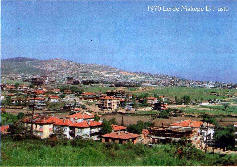
Maltepe is a district located on the coast of the Sea of Marmara, in the south-western part of the Kocaeli Peninsula in Istanbul. It covers an area of 50 square kilometres and borders the districts of Kadıköy, Kartal, Sancaktepe and Adalar. Its historical roots extend back to the early 6th century, when the settlement was known as Bryas or, in Latin, Urias. Historically, the district emerged as a coastal village named Obnias at the foot of Dragos Hill.【1】
Maltepe (Maltepe Belediyesi)
Archaeological findings date Maltepe’s history between the 4th and 13th centuries, confirming it as a continuously inhabited settlement for centuries. During the Byzantine period, a coastal village named Obnias was established at the foot of Dragos Hill, where the Bryas Palace served as a religious and spiritual centre. Emperor Theophilos built a palace in 816, modelled after the Abbasid caliphs’ palace in Baghdad.【2】
In 1080, the district was conquered by Sultan Süleyman Şah of the Seljuks, and in 1084, the Dragos River was designated as the first boundary between Anatolian Turks and Byzantines through an agreement with the Byzantine Emperor. After Süleyman Şah’s death in 1086, the agreement was broken, and during the Crusaders’ siege of İzmit in 1097, Byzantine Emperor Alexios I Komnenos established his headquarters at the fortress now known as Maltepe Şatosu.【3】 During the Crusades, Maltepe functioned as a transit zone between East and West.
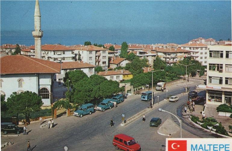
Tarihte Maltepe İlçesi (Maltepe Belediyesi)
During the Ottoman period, Maltepe and the Kocaeli Peninsula came under Ottoman administration following the Battle of Pelekanon in 1329. However, during the Ottoman Interregnum, the settlement reverted to Byzantine control in 1402. Subsequently, in 1413, Mehmed I recaptured Maltepe, which then became the second military camp and headquarters after Üsküdar along the Baghdad Road. With the capture of Aydos Castle in 1400, Maltepe remained under Ottoman territory alongside Kartal.【4】
Between the 16th and 18th centuries, Maltepe was a Greek village subordinate to Üsküdar, and urban development projects were carried out in the region by Kazasker Feyzullah Efendi.
From the second half of the 19th century, economic, social and administrative activity in the district intensified. Following the Ottoman-Russian War of 1893, a significant migration occurred from the Kemah region of Erzincan to Maltepe’s central area. In 1899, Maltepe was officially designated as a coastal village under the Adalar subdistrict; its application for municipal status was submitted the same year, and by 1901 records confirm the establishment of a municipal administration. The Maltepe Railway Station opened in 1910, but the district fell under occupation in 1918 following the occupation of Istanbul.
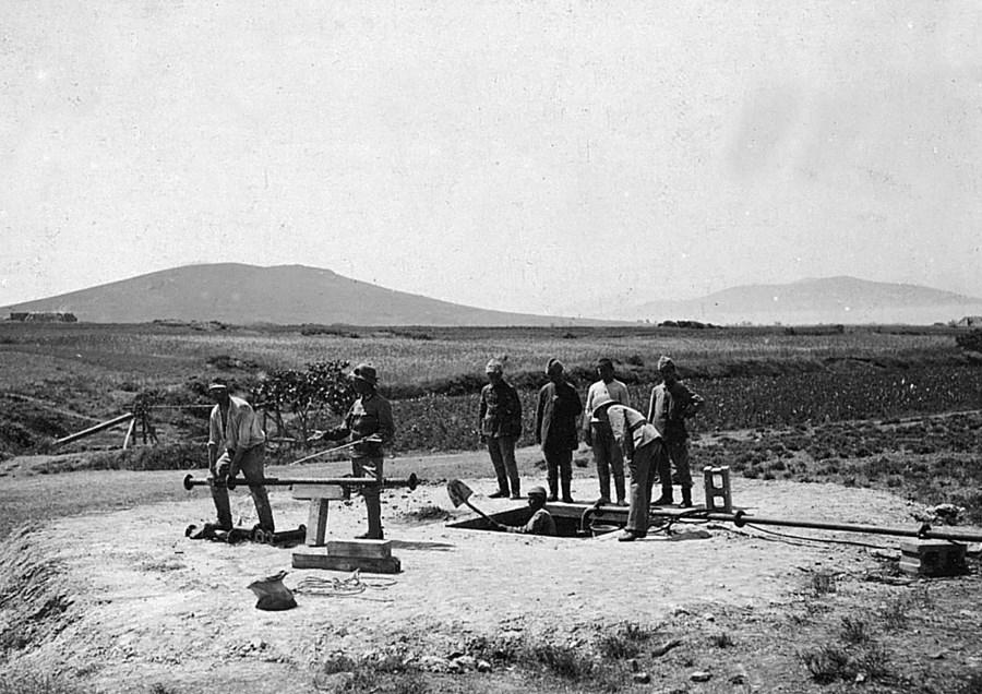
Maltepe - İstanbul (Maltepe Belediyesi)
Following the proclamation of the Republic, Turkish people from Drama were resettled in Maltepe in 1922 through the population exchange, and the Maltepe Municipality was established in 1928, becoming one of Istanbul’s oldest municipalities. In 1946, Süreyyapaşa Beach and the railway station reopened. The Bakireler Anıtı, constructed in 1953 as a trampleni for Süreyya Beach—the largest beach in Istanbul during the 1940s—became a centre where women wishing to marry made wishes.【7】
Maltepe is built on an area of 5,412 hectares, including reclaimed coastal land, and lies on the south-western edge of the Kocaeli Peninsula along the Sea of Marmara. The district’s topography rises from sea level to 480 metres towards the north, with Kayışdağı as its highest point. While the coast features flatlands, northward slopes are arranged in a series of hills, with broad plains situated between and behind them. The coastal strip consists of sand and clay, while the northern areas are covered with siliceous deposits.【8】 This siliceous mass is covered by red and brown soils, typically up to one metre thick, and possesses fertile characteristics.
The settlement pattern of the district is divided into two main zones by the E-5 (D100) highway: areas above and below the highway. The southern section of the E-5 highway, encompassing specific parcels, has been designated as an industrial zone.
There are no major rivers or permanent streams in the district. However, the Çamaşırcı Deresi, originating in Fındıklı, flows into the sea at Altıntepe and forms the boundary between Kadıköy and Maltepe. Another stream, the Çobanlar Deresi, flows from the Başıbüyük ridge, and a minor stream runs alongside the Süreyyapaşa water reservoirs. The historical Dragos River is now a small stream flowing through the western part of Maltepe before emptying into the sea.【10】 Maltepe supplies a significant portion of Istanbul’s drinking water through springs emerging in the Başıbüyük and Büyükbakkal neighbourhoods.
Since the second half of the 19th century during the Ottoman Empire, Maltepe has been a settlement marked by increasing economic, social and administrative dynamism. During this period, it exhibited a cosmopolitan character with coexisting Muslim and non-Muslim communities. Historically a summer resort favoured by the elite, the district has undergone significant demographic changes in the modern era. The establishment of workshops, factories and the construction of Süreyyapaşa Hospital from the 1960s onwards turned Maltepe into a destination for new labour migration. Between 1950 and 1980, industrialisation and major infrastructure projects triggered an apartment-building trend that attracted the middle class, who could not afford housing in central Istanbul.
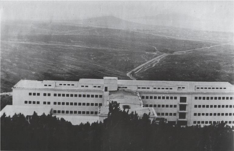
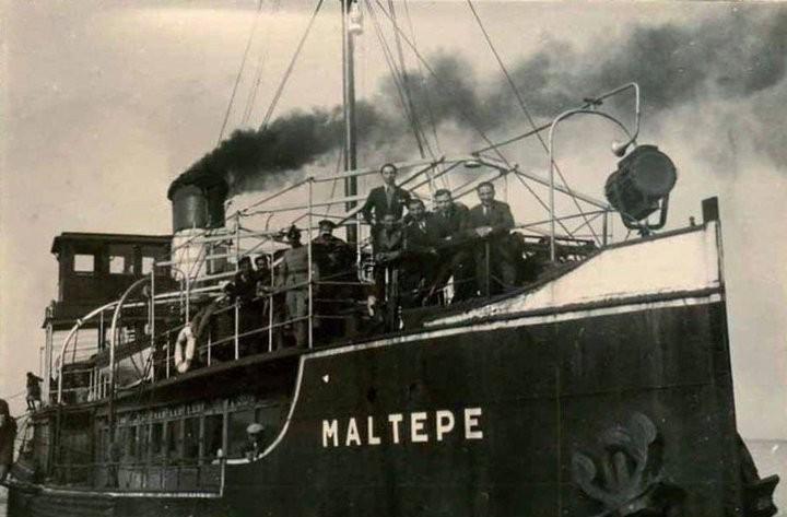
Süreyyapaşa Hastanesi (Maltepe Belediyesi)
Today, Maltepe Municipality’s future-oriented plans prioritise the concept of “urban rights,” aiming to revitalise a culture of solidarity within the district. Additional priority goals include removing barriers to gender equality, supporting disadvantaged social groups, promoting culture and art through an equitable framework, expanding quality educational activities, and encouraging mobility and civic engagement to foster healthy generations.【11】
Geographically, Maltepe lies at the transition zone between the humid climate of the Black Sea and the temperate climate of the Mediterranean. The district generally exhibits Mediterranean climate characteristics: hot and dry summers, and cool, rainy winters. Spring is cool and rainy, while autumn is mild and wet. On average, there are seven days of snowfall and 25 days of frost annually. The prevailing winds are poyraz and lodos. The lodos wind causes sea storms, while in winter, keşişleme and kible winds are also influential. Yıldız and karayel winds bring storms. During winter snowfalls, snow accumulates particularly on the slopes of Başıbüyük, Gülsuyu and Gülensu. The air masses affecting Maltepe originate from the North Adriatic in spring, moving toward the Black Sea and Crimea, and in autumn and winter from the south-eastern region of the British Isles, influencing the Marmara and Black Sea regions.【13】
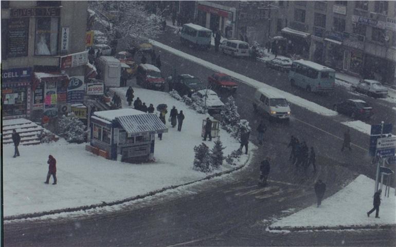
Maltepede Bir Kış Mevsimi Görüntüsü (Maltepe Belediyesi)
Maltepe is a major transportation node in Istanbul, connected by road, rail and sea routes. Road transport was significantly enhanced by the construction of the Ankara Highway (E-5/D100), which began in 1953 and bisects the district, and by the 1973 connection of the Bosphorus Bridge to this highway. More recently, the coastal road, built parallel to the shoreline, has become another major arterial route. In railway history, the Maltepe Railway Station opened in 1910 and resumed service in 1946 alongside the beach. In modern infrastructure, the M4 metro line opened in 2012, and the suburban rail line, named “Marmaray,” was reopened in 2013.
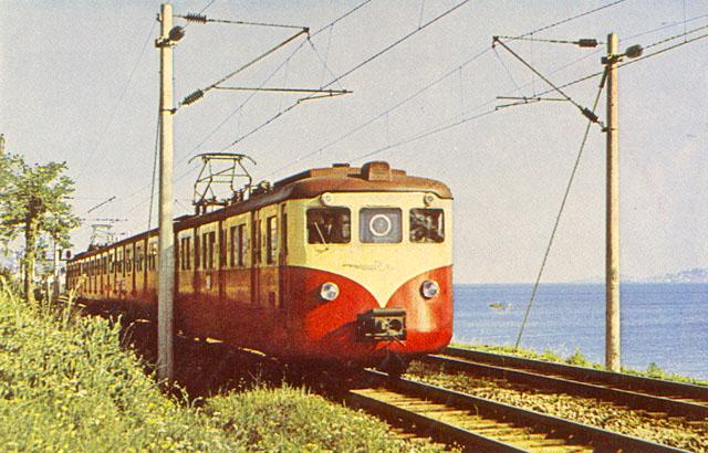
Maltepe Tren İstasyonuna Ait Bir Tren (Maltepe Belediyesi)
Since the second half of the 19th century, Maltepe has been a region of growing economic, social and administrative activity, developing an identity characterised by the coexistence of Muslim and non-Muslim communities. Following the Ottoman-Russian War of 1893, a significant migration occurred from the Kemah region of Erzincan to central Maltepe. In the early years of the Republic, Turkish people from Drama were resettled in Maltepe in 1922 through the population exchange. From the 1960s onward, the establishment of industrial facilities, workshops and factories, along with increased construction activity, attracted new labour migration. The influx of the middle class, unable to afford housing in central Istanbul, led to increased population density through apartment development. Maltepe’s population in 2023 was recorded at 523,137, with a decline of 5,407 people, or 10.3 percent, observed that year.【14】
Maltepe’s administrative history originates from its emergence as the coastal village of Obnias at the foot of Dragos Hill. Between the 16th and 18th centuries, it was administered as a Greek village under Üsküdar. In 1899, it was officially designated as a coastal village under the Adalar subdistrict. The same year, a request for municipal status was submitted, and records from 1901 confirm the establishment of a municipal administration. In 1908, Maltepe remained a township under Kartal until it regained municipal status in 1928, becoming one of Istanbul’s oldest municipalities. However, in 1980, both Maltepe and Küçükyalı municipalities were dissolved and replaced by the Maltepe Branch Directorate under the Istanbul Metropolitan Municipality, which was then attached to Kartal Municipality in 1991. Finally, by Law No. 3806 issued on 3 June 1992, Maltepe was separated from Kartal and regained its status as an independent district, with the Maltepe Municipality re-established.【15】
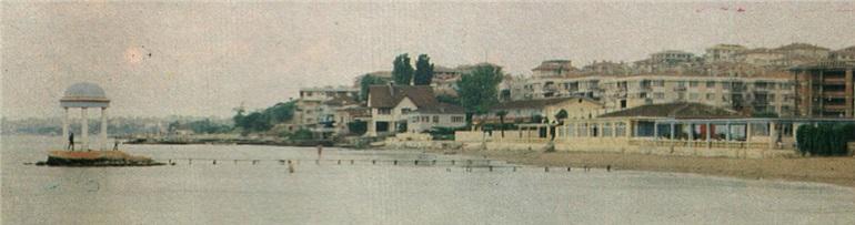
Bakireler Anıtı (Maltepe Belediyesi)
Maltepe possesses significant tourism potential through its historical and natural coastal areas. Historically, it was a favoured summer resort among the elite. The foremost tourist site is Süreyya Beach, opened in 1947 and the largest beach in Istanbul during the 1940s. The Bakireler Anıtı, one of three centres where women wishing to marry make wishes, is located on the beach and was constructed in 1953 as an important cultural landmark. In terms of historical tourism, remains of the Bryas Palace, built by Emperor Theophilos in imitation of the Abbasid palace in Baghdad, and the Küçükyalı ArkeoPark within district boundaries are notable. Excavations at Küçükyalı Bryas Palace began in 1995. In the context of coastal and recreational tourism, the Orhangazi Coastal Reclamation Park, opened in 2015 after land reclamation along the shore, is a major centre.
Istanbul Metropolitan Municipality Urban Planning Directorate. "Additional Zoning DevelopmentPlan Açıklama for the Northern Part of Maltepe E-5 (Part ofZümrütevler Mahallesinin at 1:5,000 Scale." Istanbul Metropolitan Municipality Urban Planning Directorate. Accessed December 8, 2025.https://sehirplanlama.ibb.istanbul/wp-content/uploads/2025/07/5000_RAPORU_12012024_doc_3.pdf#page=7.46
Maltepe Belediyesi. "2025-2029 Strategic Plan." Maltepe Municipality. Accessed December 8, 2025.http://www.sp.gov.tr/upload/xSPStratejikPlan/files/07xsu+maltepe_25-29_sp.pdf
Maltepe Belediyesi. "Tarihte Maltepe, Sayfa 1." Maltepe Belediyesi. Accessed December 8, 2025.https://www.maltepe.bel.tr/galeri/tarihte-maltepe?page=1
Maltepe Belediyesi. "Tarihte Maltepe, sayfa 10." Accessed December 8, 2025.https://www.maltepe.bel.tr/galeri/tarihte-maltepe?page=10
Maltepe Belediyesi. "Tarihte Maltepe, sayfa 10." Accessed December 8, 2025.https://www.maltepe.bel.tr/galeri/tarihte-maltepe?page=10
Maltepe Belediyesi. "Tarihte Maltepe, sayfa 14." Accessed December 8, 2025.https://www.maltepe.bel.tr/galeri/tarihte-maltepe?page=14
Maltepe Belediyesi. "Tarihte Maltepe, sayfa 2." Accessed December 8, 2025.https://www.maltepe.bel.tr/galeri/tarihte-maltepe?page=2
Maltepe Belediyesi. "Tarihte Maltepe, sayfa 5." Accessed December 8, 2025.https://www.maltepe.bel.tr/galeri/tarihte-maltepe?page=5
Maltepe Belediyesi. "Tarihte Maltepe, sayfa 7." Accessed December 8, 2025.https://www.maltepe.bel.tr/galeri/tarihte-maltepe?page=7
Maltepe Kaymakamlığı. "Coğrafi Yapı." Accessed December 8, 2025.http://www.maltepe.gov.tr/cografi-yapi
Maltepe Kaymakamlığı. "İlçemizin Tarihi." Accessed December 8, 2025.http://www.maltepe.gov.tr/ilcemizin-tarihi
İstanbul Büyükşehir Municipality City Planning Directorate. "Maltepe Merkez — Historical Development." Istanbul Metropolitan Municipality City Planning Directorate. Accessed December 8, 2025.https://sehirplanlama.ibb.istanbul/maltepe-merkez-tarihsel-gelisim/
[1]
İstanbul Büyükşehir Belediyesi Şehir Planlama Müdürlüğü, "1/5.000 Ölçekli Maltepe E-5 Kuzeyi (Zümrütevler Mahallesinin Bir Kısmı) İlave Nazım İmar Planı Plan Açıklama Raporu", sayfa 10, İstanbul Büyükşehir Belediyesi Şehir Planlama Müdürlüğü, erişim 8 Aralık 2025, https://sehirplanlama.ibb.istanbul/wp-content/uploads/2025/07/5000_RAPORU_12012024_doc_3.pdf#page=7.46
[2]
İstanbul Büyükşehir Belediyesi Şehir Planlama Müdürlüğü, "1/5.000 Ölçekli Maltepe E-5 Kuzeyi (Zümrütevler Mahallesinin Bir Kısmı) İlave Nazım İmar Planı Plan Açıklama Raporu", sayfa 10, İstanbul Büyükşehir Belediyesi Şehir Planlama Müdürlüğü, erişim 8 Aralık 2025,
[3]
Maltepe Kaymakamlığı, "İlçemizin Tarihi," Maltepe Belediyesi, erişim 8 Aralık 2025, http://www.maltepe.gov.tr/ilcemizin-tarihi
[4]
İstanbul Büyükşehir Belediyesi Şehir Planlama Müdürlüğü, "Maltepe Merkez — Tarihsel Gelişim," İstanbul Büyükşehir Belediyesi Şehir Planlama Müdürlüğü, erişim 8 Aralık 2025, https://sehirplanlama.ibb.istanbul/maltepe-merkez-tarihsel-gelisim/
[7]
Maltepe Belediyesi, "2025-2029 Stratejik Planı," Maltepe Belediyesi, sayfa 17, erişim 8 Aralık 2025, http://www.sp.gov.tr/upload/xSPStratejikPlan/files/07xsu+maltepe_25-29_sp.pdf
[8]
Maltepe Belediyesi, "2025-2029 Stratejik Planı," Maltepe Belediyesi, sayfa 20, erişim 8 Aralık 2025,
[10]
İstanbul Büyükşehir Belediyesi Şehir Planlama Müdürlüğü, "1/5.000 Ölçekli Maltepe E-5 Kuzeyi (Zümrütevler Mahallesinin Bir Kısmı) İlave Nazım İmar Planı Plan Açıklama Raporu", sayfa 16, İstanbul Büyükşehir Belediyesi Şehir Planlama Müdürlüğü, erişim 8 Aralık 2025,
[11]
Maltepe Belediyesi, "2025-2029 Stratejik Planı," Maltepe Belediyesi, sayfa 7, erişim 8 Aralık 2025
[13]
Maltepe Belediyesi, "2025-2029 Stratejik Planı," Maltepe Belediyesi, sayfa 22, erişim 8 Aralık 2025,
[14]
Maltepe Belediyesi, "2025-2029 Stratejik Planı," Maltepe Belediyesi, sayfa 23, erişim 8 Aralık 2025,
[15]
Maltepe Belediyesi, "2025-2029 Stratejik Planı," Maltepe Belediyesi, sayfa 23, erişim 8 Aralık 2025,
Location | southwestern part of the Kocaeli Peninsula coast of the Sea of Marmara | ||||||||
|---|---|---|---|---|---|---|---|---|---|
Neighboring Locations | Kartal, Ataşehir, Sancaktepe, Kadıköy (Karadan); Adalar (from the sea) | ||||||||
Area | 50 km² (including 5412 hectares of coastal reclamation) | ||||||||
Highest Point | Kayışdağı (480 m) | ||||||||
Former Name | Obnias (the first coastal village established) Bryas (Urias) | ||||||||
District Formation Date | 3 June 1992 (separated from Kartal) | ||||||||
Symbolic Structure | Monument of the Virgins | ||||||||
First Settlement | Obnias (a coastal village at the foot of Dragos Tepesi) | ||||||||
Municipality Establishment Year | 1928 | ||||||||
First Mayor | Selahattin Narlıgil | ||||||||
History
Geographical Structure
Social Structure
Climate
Transportation
Demographic Structure
Administrative Structure
Tourism