This article was automatically translated from the original Turkish version.
Country | Türkiye | ||||||||
|---|---|---|---|---|---|---|---|---|---|
Region | Marmara | ||||||||
Province | İstanbul | ||||||||
Number of Neighborhoods | 21 | ||||||||
Population | 462.189 (TÜİK 2024) | ||||||||
Mayor | Mesut Kösedağı (CHP) | ||||||||
District Governor | Muhittin Pamuk | ||||||||
District Coordinates | 41°07′ 00″ N 29°54′00″ E | ||||||||
Elevation | 120 m | ||||||||
Area | 25.20 km² | ||||||||
Kadıköy is a district located on the Anatolian shore of Istanbul, covering an area of 25.20 km². According to TÜİK 2024 data, the population of Kadıköy is 462,189.【1】 To the east it borders Maltepe, to the west Üsküdar and Ataşehir districts, to the south the Sea of Marmara, and to the north the Üsküdar district. The district has an average elevation of 120 meters and is built on a series of hills extending from the northeast to the southeast, including Göztepe, Fikirtepe, Acıbadem, Altıyol, Cevizlik (Küçük Moda), and Koşuyolu. Kadıköy has a coastline of approximately 21 km and is supported by active green spaces such as Fenerbahçe Park, Göztepe Park, and Özgürlük Park.
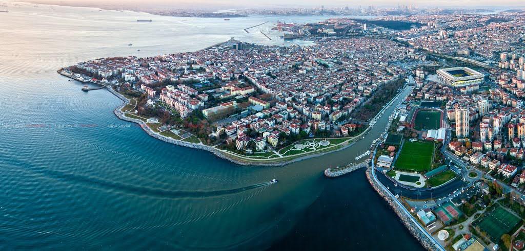
Kadıköy (T.C. Kadıköy Kaymakamlığı)
The history of Kadıköy extends back to 675 BC. One of the earliest known settlements in the area is Harhadon, a Phoenician trading colony established around 1000 BC in Fikirtepe. Fikirtepe is home to the Fikirtepe culture, the oldest known Neolithic pottery culture in Istanbul.
Near Fikirtepe, a second settlement emerged between Moda Point and Yoğurtçu, known as Chalcedon. Over time, Chalcedon became known for its Temple of Apollo. The Haydarpaşa Meadow was later used for horse racing.
In 658 BC, the Byzantines settled on the Seraglio Point, laying the foundations of Byzantium. They were captivated by the aesthetic beauty of the region. While the opposite shore (Kadıköy) was inhabited, the local population was regarded as blind, leading the Byzantines to name the area “Land of the Blind.”
Chalcedon suffered various sieges and came largely under Ottoman control between 1352 and 1353. After the conquest of Istanbul, Fatih Sultan Mehmet granted Chalcedon to Celalzade Hızır Bey, the first kadı of Istanbul and a descendant of Nasreddin Hoca’s daughter. As a result of this appointment, the settlement’s name was changed to “Kadıköy.”
During the Ottoman period, Kadıköy retained its importance as a favored summer retreat and leisure destination for high-ranking officials, as it had been in Roman and Byzantine times. Haydarpaşa, Kuşdili Deresi (Kurbağalıdere), and the slopes of Çamlıca, along with Acıbadem, Koşuyolu, and Fenerbahçe, were used as expansive meadows and recreational areas. These areas contained pavilions, seaside palaces, and gardens belonging to the Sultan and senior Ottoman officials, while village settlements occupied the interior regions.
In the 18th century, particularly during the Tulip Era, Kadıköy’s significance as a leisure destination increased. Haydarpaşa, Yoğurtçu, Moda, and Kuşdili meadows became popular recreational spots for the public. During this period, an Armenian population also began settling in the region.
In the first half of the 19th century, the general condition of the Ottoman Empire and increasing military activity led Kadıköy, despite its seasonal use, to gain military importance. In 1869, Kadıköy was incorporated into the administrative structure as part of the larger Üsküdar Sancağı.
From the second half of the 19th century, Kadıköy entered a phase of rapid development. Construction began on major military facilities such as Selimiye Barracks and Haydarpaşa Military Hospital. Subsequently, urban ferry services were introduced, and the Haydarpaşa–İzmit railway line was opened.
During this period, non-Muslim and Levantine communities settled around Moda, while high-ranking state officials built pavilions in areas such as Göztepe, Erenköy, and Bostancı during the reign of Abdülhamid II (1876–1909). Wealthy Levantines and non-Muslims constructed summer pavilions in the Fenerbahçe area.
In 1892, the establishment of Hasanpaşa Gasworks initiated the use of town gas in Kadıköy. In 1894, municipal water supply began operating. Osman Hamdi Bey became the first president of the newly established Tenth Municipal Department.
Between 1912 and 1914, during the tenure of Mayor Cemil Topuzlu, urban development projects were implemented in Kadıköy, including road and infrastructure works. Yoğurtçu Park was constructed along the banks of Kuşdili Deresi. Additionally, the municipal building, still in service today at İskele Square, was built during this period.
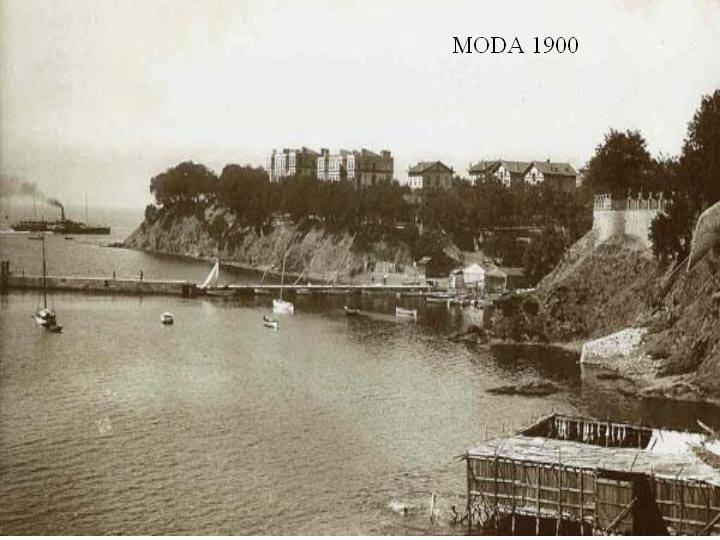
Moda, 1900 (Kadıköy Belediyesi)
Istanbul and Kadıköy were liberated from occupation forces on 6 October 1923 under the leadership of Mustafa Kemal Atatürk. Kadıköy, which had long remained a settlement under Üsküdar’s jurisdiction, gained district status on 1 September 1930 under Law No. 1612 dated 15 May 1930.【2】 At that time, Kadıköy consisted of two sub-districts: Kızıltoprak and Erenköy.
Electricity service reached the district in 1928. The tramway line, operated by a company established in 1927, began service between Üsküdar and Kısıklı in 1928 and was extended to Kadıköy in 1929.
Between 1938 and 1949, under the administration of Governor and Mayor Dr. Lütfi Kırdar, who led Istanbul’s third urban renewal program, various urban projects were carried out in Kadıköy. A bridge was constructed connecting the Kadıköy–Üsküdar road to the railway at Haydarpaşa, and Bağdat Avenue was asphalted as far as Kartal. The Kadıköy Halkevi was also built. A new water reservoir was constructed in Kozyatağı. In 1945, the Havagazı Şirketi, which operated the Hasanpaşa Gasworks, was incorporated into the Istanbul Electricity, Tramway, and Tunnel Enterprise (İETT). Bus services were introduced in 1947 to support the tramway network.
In the 1950s, infrastructure and transportation projects continued in Kadıköy. Notable projects of the period include the construction of additional piers and warehouses at Haydarpaşa Port, which began in 1953, and the dual-carriageway road from Haydarpaşa to Pendik (formerly E-5, now D-100), constructed between 1954 and 1957–1958. Additionally, the new Ankara Road, built north of Kadıköy to replace Bağdat Avenue, diverted intercity traffic away from the urban core.
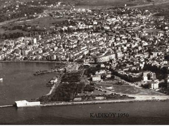
Kadıköy, 1950 (T.C. Kadıköy Kaymakamlığı)
In the 1950s, independent houses with gardens remained the dominant form of construction around Kadıköy. However, this structural transformation accelerated significantly in the 1960s. With the growth of commerce and service sectors in Kadıköy, the district emerged as a secondary metropolitan center, following Sirkeci, Eminönü, Karaköy, and Beyoğlu. During this period, Kadıköy gradually moved away from its traditional neighborhood center functions.
The opening of the first Bosphorus Bridge between 1970 and 1974 reduced the importance of sea travel, diverting most traffic to the bridge. However, accelerated migration in the 1980s and the establishment of the Metropolitan Municipality returned Kadıköy to prominence as a key settlement area through new urban planning. These plans, combined with successive building amnesty permits and land allocation certificates, increased building density while reducing social infrastructure areas.
In the 1980s, comprehensive projects were implemented in Kadıköy. The filling of Haydarpaşa Bay expanded the square; coastal reclamation between Dalyan and Bostancı enabled the construction of a seaside road; marinas were built at Kalamış Bay and Fenerbahçe; landfill works between İskele and Mühürdar expanded the square and created new green spaces. As a result of these reclamation efforts, over 900,000 square meters of new land were gained from the sea, upon which a coastline exceeding five kilometers was developed.
During the same period, various changes were made to Kadıköy Square. The old building was allocated for conservatory use; the area between the pier and the building was closed to vehicular traffic and pedestrianized. New public transport stops were arranged on the landfill area toward Haydarpaşa; pedestrian zones were introduced in some streets within the market. The park beside the pier was renovated and reorganized.
In the 1990s, various urban developments affected Kadıköy’s physical structure. The completion of the Second Circular Road and the opening of Kozyatağı connections led to the emergence of sub-centers with concentrated office use around Kozyatağı and Söğütlüçeşme. Simultaneously, the extension of the coastal road beyond Bostancı through land reclamation, the creation of a new landfill area at Moda Point, and the pedestrianization of Bahariye Avenue in 1993 marked decisive steps in the district’s transformation. Today, Kadıköy is counted among Istanbul’s leading districts due to its population density, economic vitality, and building characteristics.
Topographically, Kadıköy is situated on a series of hills extending from the northeast to the southwest. The main elevations in the district include Göztepe, Fikirtepe, Acıbadem, Altıyol, Cevizlik (Küçük Moda), and Koşuyolu hills.
The district has a coastline of approximately 21 kilometers, bordered by the Sea of Marmara. Green spaces within the district include Fenerbahçe Park, Göztepe Park, and Özgürlük Park.
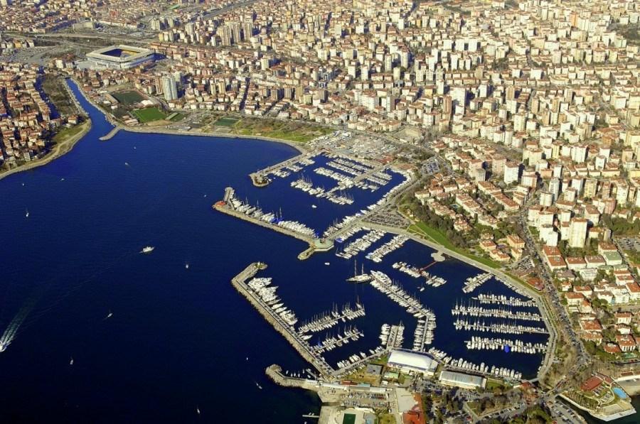
Kalamış Marina ()
Kadıköy contains 21 neighborhoods:
Kadıköy is a district on Istanbul’s Anatolian shore with an integrated transportation infrastructure encompassing road, sea, and rail systems.
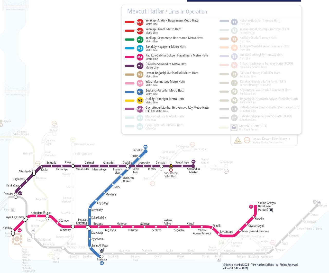
Metro Map (Metro İstanbul)
The metrobus line serves the following stations within Kadıköy: Söğütlüçeşme, Fikirtepe, and Acıbadem. Söğütlüçeşme functions as the first and last stop on the Anatolian side for the following metrobus routes:
Marmaray stations in Kadıköy include Bostancı, Suadiye, Erenköy, Göztepe, Feneryolu, Söğütlüçeşme, and Ayrılık Çeşmesi.
İETT provides bus services in Kadıköy through various bus routes.
City ferry services operated by Şehir Hatları form vital transportation links connecting Kadıköy to other regions.
Istanbul city ferry routes departing from Kadıköy include:
Bosphorus routes:
Princes’ Islands routes:
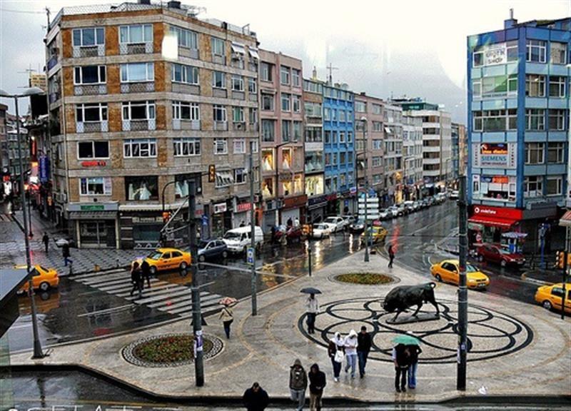
The Bull Statue in Kadıköy’s Altıyol was commissioned by Sultan Abdülaziz and created in 1864 in Paris by P. Rouillard and Thiebaut. Produced at a time when sculpture was still uncommon in the Ottoman Empire, the statue was displayed in palace gardens and private properties before being located in Harbiye between 1950 and 1969 and in front of the Kadıköy Municipality in 1969. In 1987, it was placed at its current location in Altıyol Square.【3】
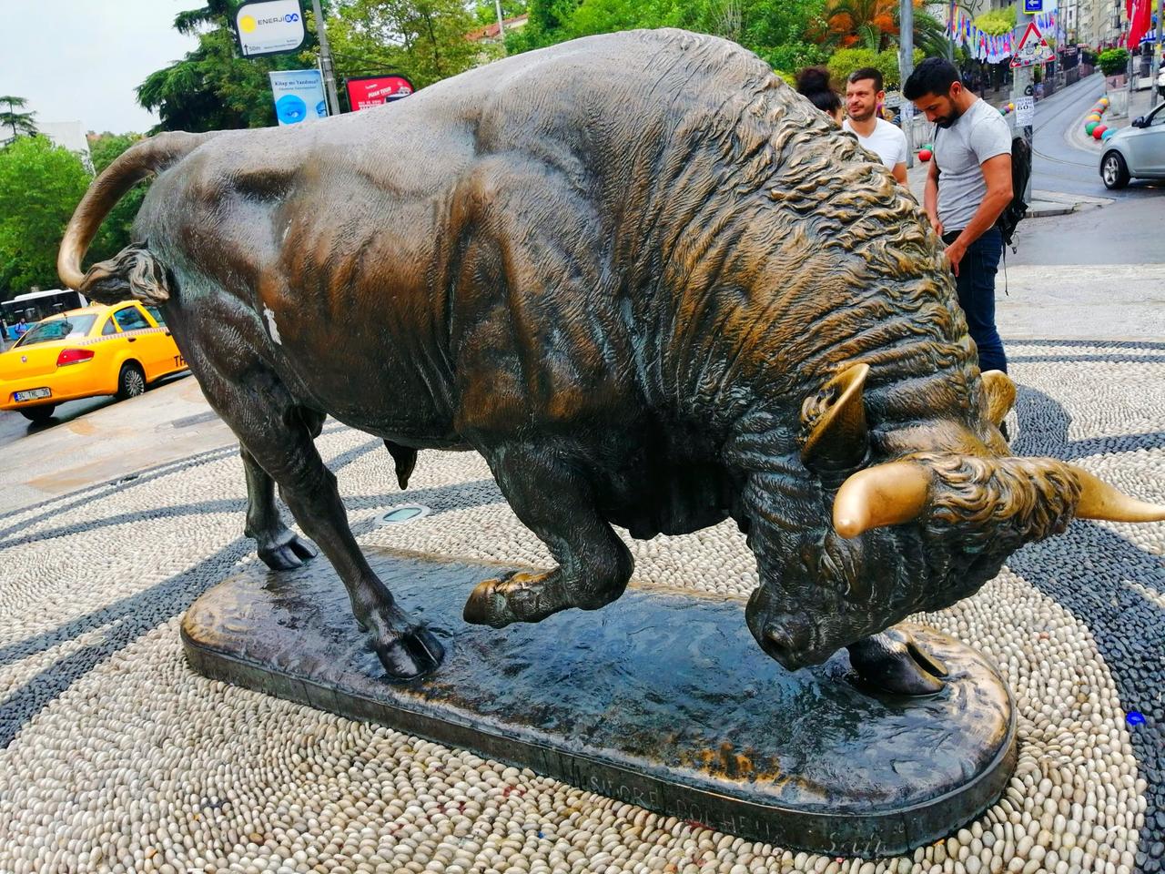
Kadıköy Bull Statue (Voylera)
The Istanbul Toy Museum was founded on 23 April 2005 by poet and writer Sunay Akın and his wife Belgin Akın. The collection, spanning from the 1700s to the present, is displayed in a historic mansion open to visitors. The museum offers a nostalgic experience for all age groups.【4】
Located in the Osmanağa neighborhood of Kadıköy, Istanbul, the church was constructed in 1694 with the permission of Metropolitan Gavril and restored in 1830 using funds collected from Russia, acquiring its present form.【5】
Haydarpaşa Train Station was constructed between 1906 and 1908 as the starting point of the Istanbul–Baghdad Railway and opened for service in 1908. It is named after Haydar Paşa, who contributed to the construction of Selimiye Barracks. Designed in a neoclassical style by two German architects, the five-story building is clad in light pink granite.
During the Ottoman period, the station served freight and passenger transport, and its importance grew as the railway network expanded into the depths of Anatolia, becoming the departure point for express trains to Anatolia. In 2010, a fire severely damaged much of the roof, and restoration works are ongoing.【6】
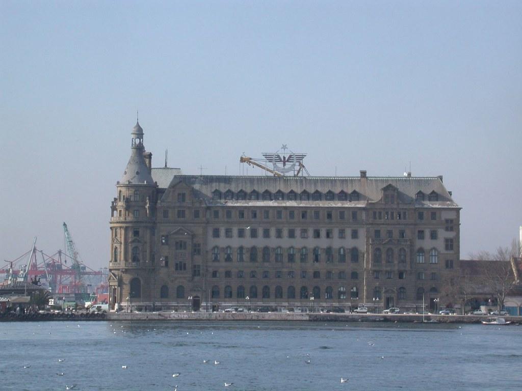
Haydarpaşa Train Station (Flickr)
Designed by architect Vedat Tek during the reign of Sultan Mehmed Reşad, the pier was constructed between 1916 and 1919. Damaged by a severe storm in the 1930s, the structure became unusable in 1986 due to declining passenger numbers. Restoration work began in 2000, and after being halted, the project was completed by the Istanbul Metropolitan Municipality in 2015 and reopened to the public.【7】
The pavilion was commissioned in the reign of Abdülhamid II by Münif Tahir Paşa from the Italian architect Rozette. After remaining vacant for many years, it was purchased in 1930 by Kazım Karabekir Paşa, who began living there with his family. The paşa established a small museum within the pavilion displaying family belongings.
The pavilion was closed in 1984 and restored by the Kazım Karabekir Foundation, established in 2002. It opened as a museum in 2005 and now presents original rooms and personal belongings of the paşa and his family to visitors.【8】
The Hasanpaşa Gasworks opened in 1892 and supplied Istanbul with lighting and fuel for 101 years. It was closed in 1993 due to technological obsolescence and environmental health concerns. After being used for a time as an İETT garage, the building was abandoned. After a prolonged struggle, it was restored. Müze Gazhane is a structure of significant local historical and public function value.【9】
The museum displays trophies, documents, and visual materials related to the club’s history. Opened in 2005 within the Şükrü Saracoğlu Stadium, it is free for visitors.【10】
Galip Paşa Mosque was built in Erenköy between 1898 and 1899 by Abdullah Galip Paşa. The structure is an example of late 19th-century Ottoman eclectic architecture.【11】
Commissioned by Ragıp Paşa in 1906 from architect Jasmund in Caddebostan, the pavilion is three stories above ground level with a total enclosed area of 2,700 square meters. It reflects late Ottoman architecture and is known for its ceiling decorations. Ragıp Paşa died here in 1920. Over time, the pavilion passed into the hands of different owners.【12】
Kadıköy hosts various cultural centers and art venues:
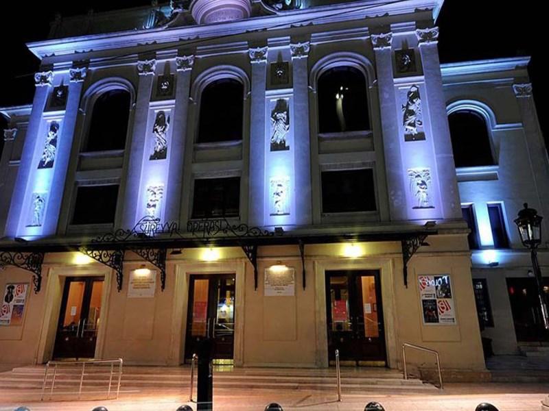
Süreyya Opera House (T.C. Kadıköy Kaymakamlığı)
Şükrü Saracoğlu Stadium, officially known as the Chobani Stadium Fenerbahçe Şükrü Saracoğlu Sports Complex, is the home ground of Fenerbahçe Sports Club. With a capacity of 47,834 spectators, it is Turkey’s fourth-largest stadium. Located on the eastern bank of Kurbağalı Dere where it flows into Kalamış Bay, on land known as Papazın Çayırı, the stadium is named after Şükrü Saracoğlu, who served as club president from 1934 to 1950 and secured the land for Fenerbahçe.
The structure has undergone several renovation phases. Most recently, between 1999 and 2006, it was gradually demolished and rebuilt as a modern facility.
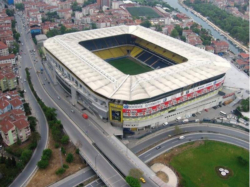
Şükrü Saracoğlu Stadium ()
Anadolu Ajansı. “Kadıköy’ün simgesi ‘Perili Köşk’ yeni sahibini bekliyor.” Accessed October 24, 2025.https://www.aa.com.tr/tr/kultur/kadikoyun-simgesi-perili-kosk-yeni-sahibini-bekliyor/2671025
Fenerbahçe Spor Kulübü. "Fenerbahçe Müzesi." Fenerbahçe Spor Kulübü. Accessed October 24, 2025.https://www.fenerbahce.org/muze
Flickr. "Haydarpasa Garı." Accessed October 24, 2025.https://www.flickr.com/photos/cybermacs/789603519/
Islam Ansiklopedisi. "Galip Paşa Camii." Islam Ansiklopedisi. Accessed October 24, 2025.https://islamansiklopedisi.org.tr/galib-pasa-camii
Kadıköy Belediyesi Culture and Arts Portal. "Culture Centers." Kadıköy Municipality Culture and Arts Portal. Accessed October 24, 2025.https://kultursanat.kadikoy.bel.tr/tr/kultur-merkezleri
Kadıköy Belediyesi. "Coğrafi Konum." Kadıköy Municipality. Accessed October 24, 2025.https://www.kadikoy.bel.tr/tr/cografi-konum
Kadıköy Belediyesi. "Fotoğraflarla Kadıköy." Accessed October 24, 2025.https://www.kadikoy.bel.tr/tr/fotograflarla-kadikoy
Kadıköy Belediyesi. “Kadıköy’ün Tarihçesi.” Kadıköy Municipality. Accessed October 24, 2025.https://www.kadikoy.bel.tr/tr/kadikoyun-tarihcesi
Kadıköy Belediyesi. “Unutulan Moda İskelesi Yıllar Sonra Kapılarını Açtı”. Accessed October 24, 2025.https://www.kadikoy.bel.tr/tr/haber-detay/unutulan-moda-iskelesi-yillar-sonra-kapilarini-acti-5641
Kadıköy Gazetesi. “Kadıköy’ün ‘Fransız’ Boğa’sı 148 yaşında”. Accessed October 24, 2025.https://www.gazetekadikoy.com.tr/yasam/kadiky039n-fransiz039-boga039si-148-yasinda
Kadıköy Municipality. "Belediye Meclisi." Kadıköy Belediyesi. Accessed October 24, 2025.https://www.kadikoy.bel.tr/tr/belediye-meclisi
Kâzım Karabekir Vakfı. “Kâzım Karabekir Müzesi Tarihçesi.” Kâzım Karabekir Vakfı. Accessed October 24, 2025.https://www.kazimkarabekirvakfi.org.tr/muze.php
Metro İstanbul. "Ağ Haritaları - İstanbul Metro Hatları Haritası." Metro İstanbul. Accessed October 24, 2025.https://www.metro.istanbul/YolcuHizmetleri/AgHaritalari
Metro İstanbul. "M4 Kadıköy-Sabiha Gökçen Havalimanı Metro Hattı." Metro İstanbul. Accessed October 24, 2025.https://www.metro.istanbul/Hatlarimiz/HatDetay?hat=M4
Metro İstanbul. "M8 Bostancı-Parseller Metro Hattı." Accessed October 24, 2025.https://www.metro.istanbul/Hatlarimiz/HatDetay?hat=M8
Metro İstanbul. "T3 Kadıköy-Moda Tramvay Hattı." Accessed October 24, 2025.https://www.metro.istanbul/Hatlarimiz/HatDetay?hat=T3
Müze Gazhane. "Hakkında." Accessed October 24, 2025.https://muzegazhane.istanbul/hakkinda/
T.C. Kadıköy Kaymakamlığı. "Fenerbahçe Şükrü Saracoğlu Stadyumu." Accessed October 24, 2025.http://www.kadikoy.gov.tr/fenerbahce-sukru-saracoglu-stadyumu-ilcemiz
T.C. Kadıköy Kaymakamlığı. "Fenerbahçe Şükrü Saracoğlu Stadyumu." Accessed October 24, 2025.http://www.kadikoy.gov.tr/fenerbahce-sukru-saracoglu-stadyumu-ilcemiz#gallery-4
T.C. Kadıköy Kaymakamlığı. “Kadıköy İlçemizin Tarihçesi.” T.C. Kadıköy Kaymakamlığı. Accessed October 24, 2025.http://www.kadikoy.gov.tr/kadikoy-ilce-tarihce#gallery-38
T.C. Kadıköy Kaymakamlığı. “Kadıköy’ün Kültür Beşiği Süreyya Operası.” Accessed October 24, 2025.http://www.kadikoy.gov.tr/kadikoyun-kultur-besigi-sureyya-operasi-ilcemiz#gallery-5
T.C.Kadıköy Kaymakamlığı Governorship. "Coğrafi Yapı." Accessed October 24, 2025.http://www.kadikoy.gov.tr/cografi-yapi
T.C.Kadıköy Kaymakamlığı Governorship. "Haydarpaşa Garı." Accessed October 24, 2025.http://www.kadikoy.gov.tr/haydarpasa-gari-ilcemiz
T.C.Kadıköy Kaymakamlığı Governorship. "Mahalli İdareler." T.C. Kadıköy District Governorship. Accessed October 24, 2025.http://www.kadikoy.gov.tr/mahalli-idareler
T.C.Kadıköy Kaymakamlığı Governorship. “Kadıköy İlçemiz.” T.C. Kadıköy District Governorship. Accessed October 24, 2025.http://www.kadikoy.gov.tr/ilcemiz
T.C.Kadıköy Kaymakamlığı Governorship. “Kadıköy İlçemizin Tarihçesi.” Accessed October 24, 2025.http://www.kadikoy.gov.tr/kadikoy-ilce-tarihce
T.C.Kadıköy Kaymakamlığı Governorship. “Kadıköy İlçemizin Tarihçesi.” Accessed October 24, 2025.http://www.kadikoy.gov.tr/kadikoy-ilce-tarihce#gallery-36
T.C.Kadıköy Kaymakamlığı Governorship. “Kadıköy İlçemizin Tarihçesi.” T.C. Kadıköy District Governorship. Accessed October 24, 2025.http://www.kadikoy.gov.tr/kadikoy-ilce-tarihce#gallery-22
T.C.Kadıköy Kaymakamlığı Governorship. “Kadıköy İlçemizin Tarihçesi.” T.C. Kadıköy District Governorship. Accessed October 24, 2025.http://www.kadikoy.gov.tr/kadikoy-ilce-tarihce#gallery-43
TCDD Taşımacılık. "Marmaray Günlük Tren Saatleri." Accessed October 24, 2025.https://www.tcddtasimacilik.gov.tr/marmaray/tr/gunluk_tren_saatleri
Türkiye Büyük Millet Meclisi. Accessed October 24, 2025.https://www5.tbmm.gov.tr/tutanaklar/KANUNLAR_KARARLAR/kanuntbmmc008/kanuntbmmc008/kanuntbmmc00801612.pdf
Türkiye İstatistik Kurumu. Accessed October 24, 2025.https://www.tuik.gov.tr/.
Voylera. "La Estatua del Toro, Kadıköy." Accessed October 24, 2025.https://voylera.com/es/story/64
İETT. "Hat/Durak Arama." İETT. Accessed October 24, 2025.https://www.iett.istanbul/RouteStation/Search
İETT. "Metrobüs Hatları." Accessed October 24, 2025.https://iett.istanbul/icerik/metrobus-hatlari
İstanbul Ansiklopedisi. "Ayia Efimia Rum Ortodoks Kilisesi." İstanbul Ansiklopedisi. Accessed October 24, 2025.https://istanbulansiklopedisi.org/handle/rek/5128
İstanbul Oyuncak Müzesi. “Hikayemiz.” İstanbul Oyuncak Müzesi. Accessed October 24, 2025.https://istanbuloyuncakmuzesi.com/pages/hikayemiz
Şehir Hatları. "Adalar Hatları." Şehir Hatları. Accessed October 24, 2025.https://sehirhatlari.istanbul/tr/seferler/ic-hatlar/adalar-hatlari-176
Şehir Hatları. "Boğaz Hatları." Accessed October 24, 2025.https://sehirhatlari.istanbul/tr/seferler/ic-hatlar/bogaz-hatlari-52
Şehir Hatları. "İç Hat Seferleri." Accessed October 24, 2025.https://sehirhatlari.istanbul/tr/seferler/ic-hatlar/istanbul-ici-hatlar-26
[1]
Türkiye İstatistik Kurumu, Erişim Tarihi 24 Ekim 2025, https://www.tuik.gov.tr/.
[2]
Türkiye Büyük Millet Meclisi, Erişim Tarihi 24 Ekim 2025, https://www5.tbmm.gov.tr/tutanaklar/KANUNLAR_KARARLAR/kanuntbmmc008/kanuntbmmc008/kanuntbmmc00801612.pdf
[3]
Kadıköy Gazetesi, “Kadıköy’ün ‘Fransız’ Boğa’sı 148 yaşında”, Erişim Tarihi 24 Ekim 2025, https://www.gazetekadikoy.com.tr/yasam/kadiky039n-fransiz039-boga039si-148-yasinda
[4]
İstanbul Oyuncak Müzesi, “Hikayemiz”, Erişim Tarihi: 24 Ekim 2025, https://istanbuloyuncakmuzesi.com/pages/hikayemiz
[5]
İstanbul Ansiklopedisi, “Ayia Efimia Rum Ortodoks Kilisesi”, Erişim Tarihi: 24 Ekim 2025, https://istanbulansiklopedisi.org/handle/rek/5128
[6]
T.C. Kadıköy Kaymakamlığı, “Haydarpaşa Garı İlçemiz”, Erişim Tarihi: 24 Ekim 2025, http://www.kadikoy.gov.tr/haydarpasa-gari-ilcemiz
[7]
Kadıköy Belediyesi, "Unutulan Moda İskelesi Yıllar Sonra Kapılarını Açtı", Erişim Tarihi 24 Ekim 2025, https://www.kadikoy.bel.tr/tr/haber-detay/unutulan-moda-iskelesi-yillar-sonra-kapilarini-acti-5641
[8]
Kâzım Karabekir Vakfı, “Kâzım Karabekir Müzesi Tarihçesi”, Erişim Tarihi: 24 Ekim 2025, https://www.kazimkarabekirvakfi.org.tr/muze.php
[9]
Müze Gazhane, “Hakkında”, Erişim Tarihi: 24 Ekim 2025, https://muzegazhane.istanbul/hakkinda/
[10]
Fenerbahçe Spor Kulübü, "Fenerbahçe Müzesi", Erişim Tarihi: 24 Ekim 2025, https://www.fenerbahce.org/muze
[11]
İslam Ansiklopedisi, “Galip Paşa Camii”, Erişim Tarihi: 24 Ekim 2025, https://islamansiklopedisi.org.tr/galib-pasa-camii
[12]
Anadolu Ajansı, "Kadıköy'ün simgesi 'Perili Köşk' yeni sahibini bekliyor”, Erişim Tarihi: 24 Ekim 2025, https://www.aa.com.tr/tr/kultur/kadikoyun-simgesi-perili-kosk-yeni-sahibini-bekliyor/2671025
Country | Türkiye | ||||||||
|---|---|---|---|---|---|---|---|---|---|
Region | Marmara | ||||||||
Province | İstanbul | ||||||||
Number of Neighborhoods | 21 | ||||||||
Population | 462.189 (TÜİK 2024) | ||||||||
Mayor | Mesut Kösedağı (CHP) | ||||||||
District Governor | Muhittin Pamuk | ||||||||
District Coordinates | 41°07′ 00″ N 29°54′00″ E | ||||||||
Elevation | 120 m | ||||||||
Area | 25.20 km² | ||||||||
History
Ancient Period
Roman and Byzantine Period
Ottoman Period
Republican Period
1950s and Beyond
Kadıköy from the 1990s to the Present
Geographical Structure
Transportation
Metro Lines
Tramway Lines
Metrobus Lines
Marmaray
Bus Lines
Maritime Transport
Historical and Cultural Heritage Sites in Kadıköy
Kadıköy Bull Statue
Istanbul Toy Museum
Ayia Efimia Greek Orthodox Church
Haydarpaşa Train Station
Moda Pier
Kazım Karabekir Paşa Museum
Müze Gazhane
Fenerbahçe Museum
Galip Paşa Mosque
Ragıp Paşa Pavilion
Culture and Art
Şükrü Saracoğlu Stadium