


This article was automatically translated from the original Turkish version.
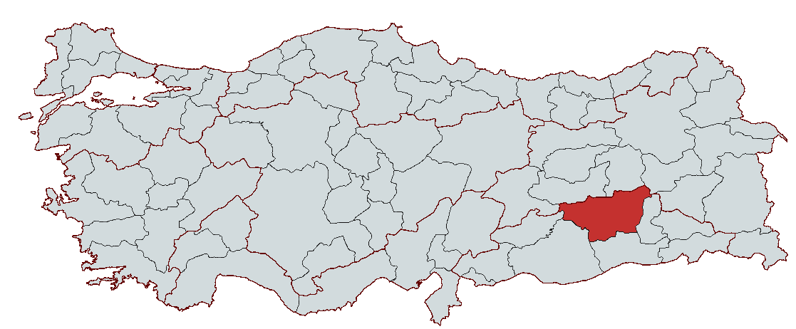
Diyarbakır
Country | Türkiye | ||||||||
|---|---|---|---|---|---|---|---|---|---|
Region | Southeastern Anatolia Region | ||||||||
Population | 1,833,684 (2023) | ||||||||
Area | 15,271 km² | ||||||||
Climate | Continental Climate | ||||||||
Important Structure | Diyarbakır Walls Hevsel Gardens Ulu Mosque Malabadi Bridge Zerzevan Castle | ||||||||
Governor | Hüseyin Aksoy (as of 2024) | ||||||||
Mayor | Ayşe Serra Bucak Küçük | ||||||||
Area Code(s) | 412 | ||||||||
License Plate Code | 21 | ||||||||
Diyarbakır is a historic and culturally rich city located in southeastern Türkiye, on the right bank of the Tigris River. Throughout history, it has served as a home to numerous civilizations and has been a crossroads of major trade routes. With its fertile lands irrigated by the Karacadağ and Tigris Valley, it holds significant importance in agriculture. Today, Diyarbakır, with its historical structures, cultural heritage, and growing economy, is one of the region’s key centers.
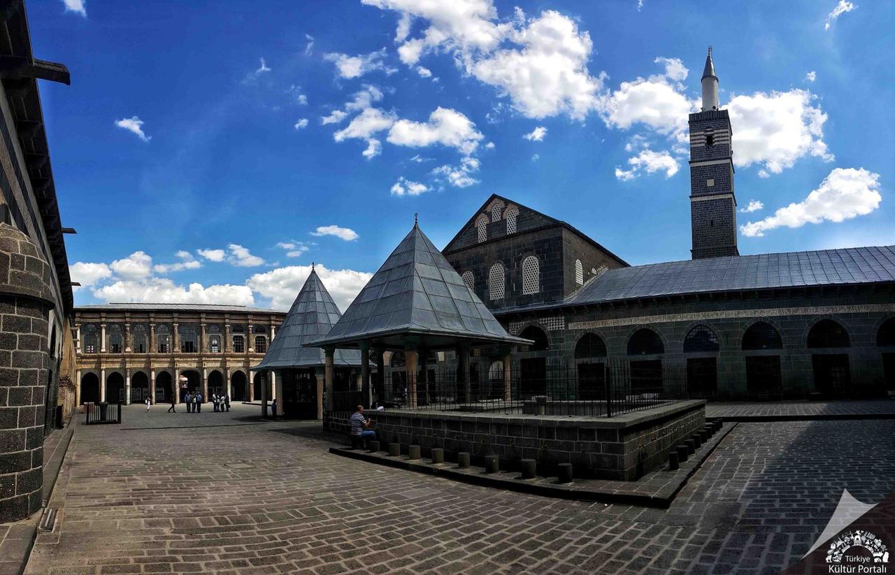
Ulu Cami (Photo: Ali Düzdemir, Türkiye Kültür Portalı)
The city’s earliest known name is Amida, as recorded in Assyrian sources. During the Roman and Byzantine periods, it was referred to as Amid, O’mid, Emid, and Amide. After the region was conquered by Muslim Arabs, it began to be called Diyar-ı Bekr, named after the Bekir bin Vâil tribe that settled there. During the Ottoman period, the city was known as Diyarbekir and officially adopted the name Diyarbakır in 1937.
Diyarbakır’s prehistoric past extends back to 10,000 BCE, as revealed by recent archaeological excavations. The Körtik Tepe and Çayönü digs show that this region is home to some of the earliest examples of agricultural village life. Research at Çayönü has demonstrated that its inhabitants transitioned from nomadic lifestyles to settled communities, domesticating wild wheat, lentils, sheep, and goats. During the Halaf Culture period (circa 5000 BCE), Diyarbakır and its surroundings became one of the major cultural centers of northern Mesopotamia.
Successively, the Hurrians, Mitanni, Hittites, Assyrians, Urartians, Medes, Persians, Alexander the Great, and the Seleucids ruled the region. Under Roman and Byzantine rule, Diyarbakır gained strategic importance as a frontier fortress against the Sassanian Empire to the east. In 349 CE, Byzantine Emperor Constantius II fortified the city with strong walls to defend against the Sassanians.
Diyarbakır was conquered in 639 CE by Islamic armies under Khalid ibn al-Walid and came under Muslim Arab control. During the Umayyad and Abbasid periods, the region frequently served as a battleground against Byzantine incursions and Kharijite revolts. Abbasid Caliph Mu'tazz bi-llah captured the city in 899 and strengthened its fortifications. In the 10th century, local dynasties such as the Hamdanids, Buyids, and Marwanids assumed control. The Marwanids, in the 11th century, established a strong administration in Diyarbakır, developing its infrastructure and constructing major works such as the Tigris Bridge.
Following the Battle of Manzikert in 1071, Diyarbakır came under Seljuk rule and was captured in 1085 by Sultan Malik-Shah. During the Seljuk period, the city was governed by local Turkish beyliks such as the Inalids, Nisanids, Hasankeyf Artuqids, and Mardin Artuqids. During this time, significant structures including the Ulu Camii, Mesudiye Medresesi, and Artuklu Köşkü were built.
In 1183, Saladin conquered Diyarbakır and brought it under Ayyubid rule. During this period, the city became an important cultural and scientific center. Reclaimed by the Ayyubids in 1232, it was occupied by the Mongols in 1259. In the 14th century, the Ilkhanids, Jalayirids, and Artuqids ruled the region. In 1401, Karayücelik Osman Bey captured Diyarbakır, enabling the Akkoyunlu to establish a strong regional administration. Under Uzun Hasan, Diyarbakır became one of the most important centers of the Akkoyunlu State.
Diyarbakır was conquered in 1515 by Bıyıklı Mehmed Pasha under Sultan Yavuz Selim and incorporated into Ottoman territory. It became the capital of the Diyarbekir Eyalet and one of the most important cities on the Ottoman eastern frontier. During the 16th century, under Ottoman administration, mosques, medreses, hans, and caravanserais were constructed, enhancing Diyarbakır’s economic and cultural significance.
Evliya Çelebi noted in the 17th century that Diyarbakır had 54 neighborhoods, large bazaars, and a bedesten with 1,008 shops. During the Ottoman era, silk weaving, leatherworking, coppersmithing, and jewelry-making were major commercial activities. The city also served as a key stopover for trade caravans coming from the east.
With the proclamation of the Republic, Diyarbakır became a province of the Republic of Türkiye in 1923 and officially adopted the name Diyarbakır in 1937. During the Republican period, major investments were made in infrastructure, transportation, education, and healthcare, leading to growth in industry and agricultural production.
In the early years of the Republic, Diyarbakır emerged as a major center for agriculture and animal husbandry. Starting in the 1950s, industrialization efforts began, modernizing agricultural production and driving economic development. From the 1980s onward, Diyarbakır experienced rapid growth due to migration movements, accelerating its urbanization process.
In recent years, investments in universities, cultural events, and tourism have established Diyarbakır as one of the region’s most important centers. The Diyarbakır Walls and Hevsel Gardens were inscribed on the UNESCO World Heritage List in 2015, recognizing them as internationally significant cultural heritage.
Diyarbakır is located in the central part of Southeastern Anatolia, at the northern edge of Mesopotamia. It borders Batman and Muş to the east, Siirt to the southeast, Şanlıurfa and Adıyaman to the west, Malatya to the northwest, Elazığ and Bingöl to the north, and Mardin to the south. The city is built on a vast basalt plateau at the foot of Karacadağ, approximately 100 meters above the Tigris River. The Diyarbakır Basin is shaped by the Tigris River and its tributaries running in an east-west direction. To the north lie the Southeastern Taurus Mountains, and to the south, the Karacadağ Volcanic Massif.
The province’s topography can be summarized as follows:
Diyarbakır has a continental climate with extremely hot and dry summers and cold, wet winters.
Diyarbakır’s natural vegetation is dominated by steppe (bozkır) plant species. Herbaceous plants green briefly in spring and then dry out.
The most important river in Diyarbakır is the Tigris River.
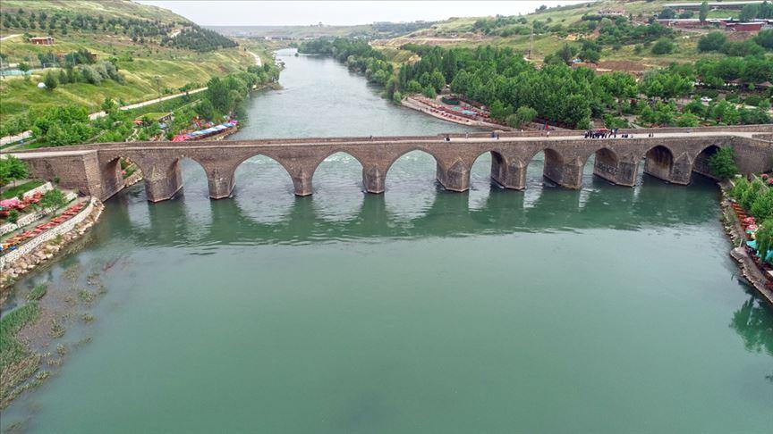
Tigris River (Source: Anadolu Ajansı)
Diyarbakır is a region rich in natural resources, including volcanic rocks, mineral deposits, and fertile agricultural land.
Minerals and Volcanic Rocks
Diyarbakır is Türkiye’s 12th most populous province, with a steadily increasing population over the years. As one of the economic and cultural centers of Southeastern Anatolia, Diyarbakır stands out due to rapid population growth and migration trends.
Diyarbakır’s population has shown continuous growth in recent years. According to TÜİK data, the population growth is as follows:
These figures indicate that Diyarbakır’s population has increased by approximately 50,000 people over the past five years. The main drivers of population growth are natural increase (high birth rates), rural-to-urban migration, and urbanization.
Diyarbakır is among the provinces with the highest population growth rates in Türkiye. Fertility rates are high: while the national average is 1.88 children per woman, Diyarbakır’s rate is 3.5 children. Migration from rural areas to urban centers continues. Particularly during the 1990s, large waves of migration occurred from rural areas to the city center of Diyarbakır. In recent years, Diyarbakır has experienced emigration to provinces such as Istanbul, İzmir, and Mersin. However, due to its high youth population, natural population growth continues.
Diyarbakır is one of Türkiye’s youngest provinces.
The urbanization rate in Diyarbakır is very high. The combined population of the central districts of Bağlar, Kayapınar, Sur, and Yenişehir is 1,141,865, representing approximately 62% of the province’s total population. The remaining 38% reside in the other 13 districts.
Throughout history, Diyarbakır has functioned as a bridge between Anatolia and Mesopotamia and has been one of the key junctions of trade routes. Thanks to its fertile lands, strategic location, and rich natural resources, it has remained an economically vibrant city. Agriculture, animal husbandry, and trade continued to form the backbone of the city’s economy during the Ottoman and Republican periods. Today, industry, mining, trade, and tourism are key sectors shaping Diyarbakır’s economy.
Diyarbakır is one of Türkiye’s largest provinces in terms of agricultural land, with approximately 650,000 hectares of cultivable area. Wheat, barley, lentils, rice, cotton, maize, and sunflower are the leading agricultural products. Additionally, Diyarbakır watermelon, known for its size and unique flavor, is one of Türkiye’s most famous agricultural products. Vegetable production has also increased in recent years. Irrigation investments under the Southeastern Anatolia Project (GAP) have significantly boosted agricultural output. Projects such as Atatürk Dam, Karakaya Dam, Batman Dam, and Dicle Dam have transformed dryland farming areas into irrigated farmland, increasing productivity.
Small-scale animal husbandry is widespread in Diyarbakır, with sheep and goat breeding holding particular importance. In recent years, large-scale animal husbandry has also expanded, with growth in dairy production and livestock farming. Poultry farming and beekeeping are also significant livelihood sources. Diyarbakır has more than 7,000 bee hives, and honey production is steadily increasing.
Diyarbakır is recognized as one of Türkiye’s major oil-producing regions. The first oil well in the city was drilled in 1961, and oil production continues under the management of Türkiye Petrolleri Anonim Ortaklığı (TPAO). Currently, approximately 16% of Türkiye’s total crude oil production comes from Diyarbakır. When combined with Batman and Şırnak, this highlights the region’s significance as a key energy source for Türkiye. Additionally, copper deposits are found in Ergani and lignite deposits in Hazro district. However, lignite reserves are not sufficient for large-scale production. Another important natural resource is Karacadağ Basalt. Due to its hardness, durability, and resistance to abrasion, this stone is widely used in construction and landscaping.
The industrial sector in Diyarbakır has developed significantly in recent years. Organized industrial zones (OSB) have promoted manufacturing and attracted investors. Key industries in the city include food processing, textiles, plastics, cement, agricultural machinery, livestock, dairy, and dairy products. Although private sector investment in industry has not yet reached desired levels, state-supported incentives continue to drive industrial growth in Diyarbakır.
Diyarbakır has historically been a crossroads of trade routes and remains a major hub for trade between the Middle East and western Türkiye. The city plays a significant role in exports to Iraq, Syria, and Iran. Small-scale traders and commercial establishments hold an important place in the city’s economy. Diyarbakır’s commercial life is centered on the sale of large-scale agricultural and livestock products, textiles, construction materials, and foodstuffs.
Diyarbakır occupies a strategic position in terms of transportation. The city is one of the most developed in the region in terms of road, air, and rail connectivity.
Diyarbakır, with its rich historical and cultural heritage, is among the world’s most significant cities. One of its most important heritage components is the Diyarbakır Walls and Hevsel Gardens, inscribed on the UNESCO World Cultural Heritage List in 2015. Built by the Romans in the 5th century and restored by successive civilizations, the Diyarbakır Walls reflect the city’s historical and cultural richness. The Hevsel Gardens, located along the Tigris River, have been used for agricultural production for thousands of years and represent a fertile oasis that illustrates the history of Diyarbakır’s agricultural and irrigation systems. In 2015, the Hevsel Gardens, together with the Diyarbakır Walls, were officially recognized as an internationally significant cultural heritage site.
The Diyarbakır Walls, resembling the silhouette of a carp, are considered one of the longest, widest, and most robust walls in the world after the Great Wall of China. Although the exact date of construction is unknown, it is believed to date back to the Hurrian period between 3000 and 2500 BCE. However, the walls acquired their current form during the reign of Roman Emperor Constantius II in 349 CE.
The Diyarbakır Walls consist of a total of 101 towers, including inner and outer fortifications. Notable towers include Dağ Kapı Burcu, Selçuklu Burcu, Ulu Beden Burcu, Yedi Kardeş Burcu, Nur Burcu, Keçi Burcu, Leblebi Kıran Burcu, and Fındık Burcu, each distinguished by inscriptions, reliefs, and architectural features. Towers are categorized into three types based on their plan: circular, square, and polygonal. The total perimeter of the walls, including the inner fortress, is approximately 5,800 meters.
There are a total of 34 gates in the walls, categorized as main gates, minor gates, and later additions. The outer walls have four main gates: Dağ Kapı (north), Urfa Kapı (west), Mardin Kapı (south), and Yeni Kapı (east). Inside the inner fortress, Saray Kapı and Küpeli Kapı open inward, while Oğrun Kapı and Fetih Kapı open outward. In later years, Tek Kapı and Çift Kapı were constructed to meet transportation needs.
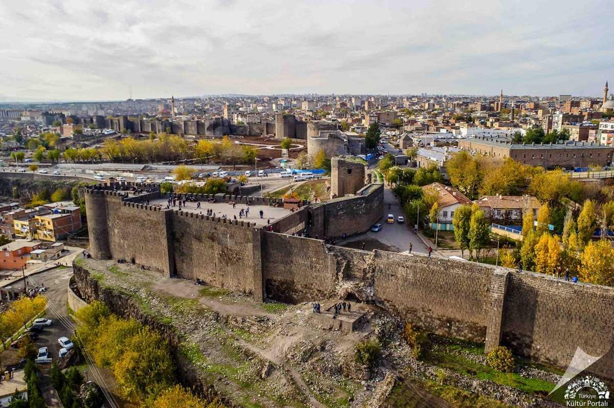
Diyarbakır Walls (Photo: Türkiye Kültür Portalı)
The Hevsel Gardens, located along the Tigris River, constitute an important ecosystem with fertile soils that have been used for agricultural production for thousands of years. Covering an area of approximately 700 hectares, the region has been recognized by UNESCO for its biodiversity and agricultural heritage. The Hevsel Gardens highlight the importance of agriculture and water resources in the region and hold immense cultural and economic value for Diyarbakır.
Located between Diyarbakır and Mardin, Zerzevan Castle is a military structure used as a frontier garrison during the Roman Empire. Strategically positioned to control a wide area, it served as a Roman frontier garrison. The castle’s history extends back to the Assyrian period and was also used during the Persian period, later becoming a settlement under the Eastern Roman Empire.
Inside the castle is a Mithraeum (Temple of Mithras), the most recently discovered Mithras temple along Rome’s eastern frontier. Zerzevan Castle is currently on UNESCO’s tentative World Heritage List.
The Malabadi Bridge, located in Diyarbakır’s Silvan district, is one of the largest stone bridges from the Middle Ages with the greatest arch span. It was constructed in 1147 by Artuqid ruler Hüsamettin Timurtaş. The bridge is approximately 150 meters long with an arch span of 38.6 meters. It is notable for its stonework and architectural details.
Ulu Camii
The Diyarbakır Ulu Camii is among the oldest mosques in Anatolia. It was established in 639 CE after the city’s conquest by Muslim forces, when the Mar Toma Church was converted into a mosque. Inspired by the architecture of the Umayyad Mosque in Damascus, it is regarded as the fifth holiest site in the Islamic world. The structure has undergone repairs and renovations during various Islamic dynasties. Its interior is adorned with fine stone craftsmanship and elegant examples of calligraphy art. A historic sundial in the courtyard is also notable. The courtyard also contains the Shafi’i and Hanafi sections and the Mesudiye Medresesi.
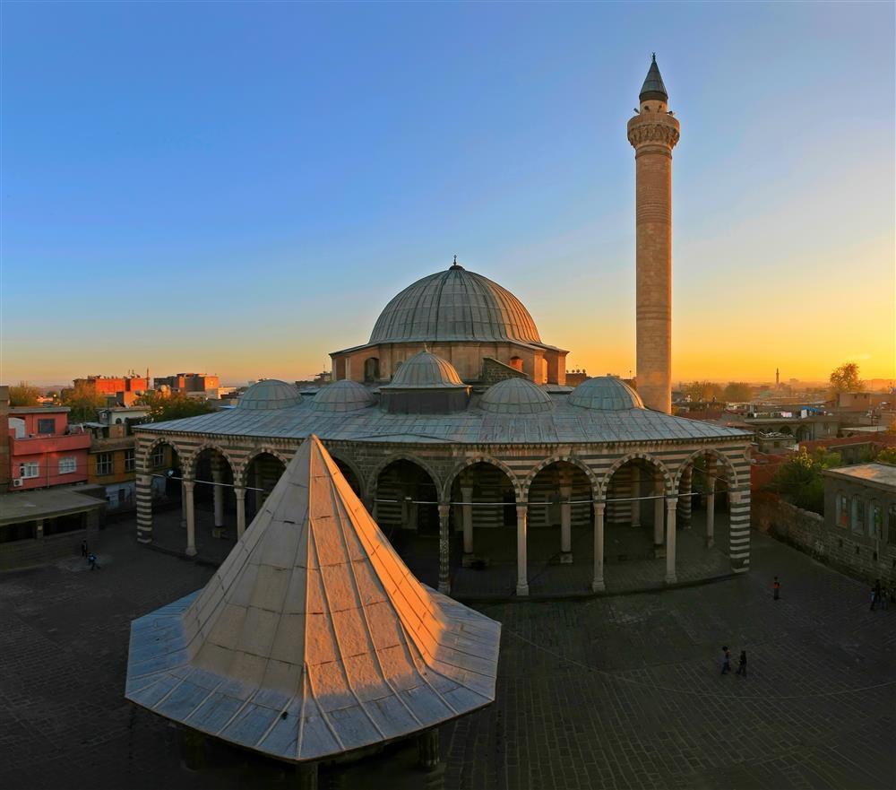
Behram Paşa Camii (Photo: Diyarbakır İl Kültür ve Turizm Müdürlüğü)
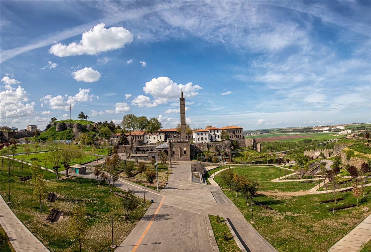
Area of Süleyman Paşa Camii and Companions’ Tombs (Photo: T.C. Diyarbakır Valiliği)
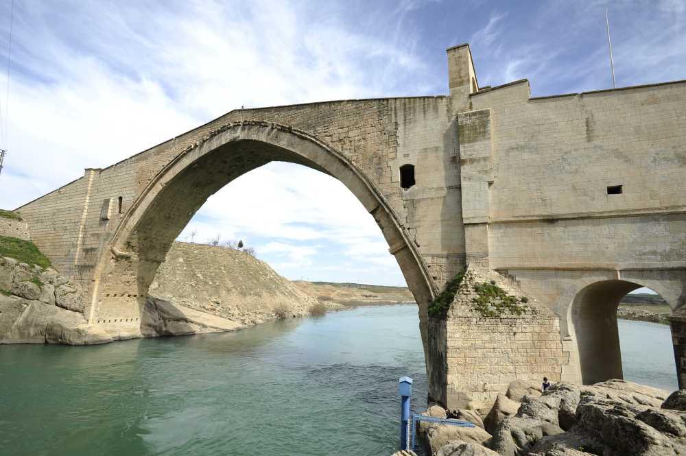
Malabadi Bridge (Photo: Diyarbakır İl Kültür ve Turizm Müdürlüğü )
Diyarbakır cuisine features a rich cultural heritage and distinctive local flavors. Notable local dishes include:
In addition, other regional delicacies widely consumed in the area include Cimili Tatlısı, Kaburga Dolması, Kağırdaklı Ekmek, Kemikli Kebap, Kenger Meftunesi, Lepik Köftesi, Mastava Aşı, Patlıcan Meftunesi, Simindirik Çorbası, Tavuk Eşkenesi, Tirit Yemeği, Örgü Peyniri, Karacadağ Rice, and Çermik Pepper.
Public administration in Diyarbakır is carried out by two main institutions: the governorship and the municipality. The governorship represents central government, while the municipality manages local services. The Diyarbakır Governorship is a central government body under the Ministry of Interior. The governor is appointed by the President of the Republic and is responsible for the overall administration of the province. On 19 September 2024, Hüseyin Aksoy was appointed as Governor of Diyarbakır by the Governorship Decree.
Diyarbakır Municipality serves as the local government body. The mayor, municipal council, and executive committee are responsible for planning and implementing local services. The mayor and municipal council members are elected by the public and serve as representatives of the local population. In the local elections held on 31 March 2024, Demokratik Emek Partisi (DEM) candidate Ayşe Serra Bucak Küçük was elected Mayor of Diyarbakır Metropolitan Municipality with 64.09% of the vote. In district elections, DEM won in Bağlar, Sur, Kayapınar, and Yenişehir districts; AK Party won in Çermik and Çınar districts; and HÜDA PAR won in Eğil district.
Coğrafya.gen.tr. "Diyarbakır Ekonomisi." Accessedhttps://www.cografya.gen.tr/tr/diyarbakir/ekonomi.html.
Diyarbakır Büyükşehir Municipality. "Coğrafi Bilgiler." Diyarbakır Metropolitan Municipality. Accessedhttps://www.diyarbakir.bel.tr/diyarbakir/genel-bilgiler/cografi-bilgiler.html.
Diyarbakır Kültür ve Turizm Derneği. "Diyarbakır Coğrafi Yapısı." Diyarbakır Kültür ve Turizm Derneği. Accessedhttps://diyarbakirkulturturizm.org/Info/Details/Diyarbakir-Cografi-Yapisi/56.
Diyarbakır İl Directorate of Agriculture and Forestry. "Coğrafya." Diyarbakır Provincial Directorate of Agriculture and Forestry. Accessedhttps://diyarbakir.tarimorman.gov.tr/Menu/31/Cografya.
Diyarbakır İl Directorate of Culture and Tourism. "Coğrafya." Diyarbakır Provincial Directorate of Culture and Tourism. Accessedhttps://diyarbakir.ktb.gov.tr/TR-56881/cografya.html.
Diyarbakır İli Promotion and Research Foundation (DİTAV). "Coğrafi Bilgileri." Diyarbakır Province Promotion and Research Foundation (DİTAV). Accessedhttps://www.ditav.org/index.php/diyarbakir/cografi-bilgileri.
Invest Diyarbakır. "Coğrafi Bilgiler." Invest Diyarbakır. Accessedhttps://www.investdiyarbakir.com/diyarbakir/cografi-bilgiler--307.
Ministry of Culture and Tourism of the Republic of Turkey. Photographs and Videos [JPG].Diyarbakır İl Directorate of Culture and Tourism. Accessed February 21, 2025.https://diyarbakir.ktb.gov.tr/TR-56932/fotograf-ve-videolar.html
Nüfusu.com. "Diyarbakır Nüfusu." Nüfusu.com. Accessedhttps://www.nufusu.com/il/diyarbakir-nufusu.
T.C. Ministry of Culture and Tourism. Diyarbakır Ulu Cami - Diyarbakır [JPG]. Türkiye Kültür Portalı. Accessed February 21, 2025.https://www.kulturportali.gov.tr/turkiye/diyarbakir/gezilecekyer/ulucam
T.C. Ministry of Culture and Tourism. Photographs and Videos [JPG].Diyarbakır İl Directorate of Culture and Tourism. Accessed February 21, 2025.https://diyarbakir.ktb.gov.tr/TR-56932/fotograf-ve-videolar.html
T.C. Ministry of Culture and Tourism.Diyarbakır Surları [JPG]. Türkiye Kültür Portalı. Accessed February 21, 2025.https://www.kulturportali.gov.tr/portal/diyarbakir-surlari
T.C.Diyarbakır Valiliği. Hz.Süleyman Camii and Companions' Graves [JPG]. Accessed February 21, 2025.http://www.diyarbakir.gov.tr/hz-suleyman-camii-ve-sahabe-kabirleri
TRT Haber. "Diyarbakır Yerel Seçim Sonuçları." TRT Haber. Accessedhttps://secim.trthaber.com/diyarbakir/yerel-secim-sonuclari.
Türkiye Cumhuriyeti Kalkınma Bakanlığı ve Karacadağ Kalkınma Ajansı. Diyarbakır İli Sanayi Profilinin Oluşturulması. 2013.
Türkiye İstatistik Kurumu (TÜİK). "CİP." Türkiye İstatistik Kurumu. Accessedhttps://cip.tuik.gov.tr/.
Ömer Yasin, Ergin. Dicle Nehri son 30 yılın en berrak görünümünde [JPG]. Anadolu Ajansı. Accessed February 21, 2025.

Diyarbakır
Country | Türkiye | ||||||||
|---|---|---|---|---|---|---|---|---|---|
Region | Southeastern Anatolia Region | ||||||||
Population | 1,833,684 (2023) | ||||||||
Area | 15,271 km² | ||||||||
Climate | Continental Climate | ||||||||
Important Structure | Diyarbakır Walls Hevsel Gardens Ulu Mosque Malabadi Bridge Zerzevan Castle | ||||||||
Governor | Hüseyin Aksoy (as of 2024) | ||||||||
Mayor | Ayşe Serra Bucak Küçük | ||||||||
Area Code(s) | 412 | ||||||||
License Plate Code | 21 | ||||||||
No Discussion Added Yet
Start discussion for "Diyarbakır (Province)" article
Etymology
History
Prehistoric Era and Early Settlements
Islamic Period and Turkish Rule
Ayyubid, Mongol, and Akkoyunlu Periods
Ottoman Period
Republican Era and Present Day
Geography
Location and Topography
Climate
Vegetation
Rivers and Dams
Natural Resources
Demographic Structure
Population Changes Over the Years
Population Growth Rate and Migration
Age and Gender Distribution
Urban and Rural Population Distribution
Population Distribution by District
Economy
Agriculture
Animal Husbandry
Mining and Natural Resources
Industry
Trade and Logistics
Transportation and Infrastructure
Culture and Tourism
UNESCO World Heritage Sites
Diyarbakır Walls
Hevsel Gardens
Zerzevan Castle
Malabadi Bridge
Mosques
Other Mosques
Churches
Tombstones and Medreses
Manors and Pavilions
Natural Sites
Poets, Writers, and Intellectuals from Diyarbakır
Manors and Pavilions
Bridges
Museums
Cuisine
Local Government