


This article was automatically translated from the original Turkish version.
+1 More
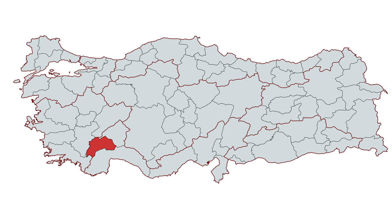
Burdur
Country | Türkiye | ||||||||
|---|---|---|---|---|---|---|---|---|---|
Region | Mediterranean | ||||||||
Population (Number) | 275826 | ||||||||
Area | 6883 km² | ||||||||
Elevation | 950 m | ||||||||
Climate | Continental climate and Mediterranean climate | ||||||||
Important Structure | Sagalassos Ancient City İnsuyu Cave | ||||||||
Governor | Tülay Baydar Bilgihan | ||||||||
Mayor | Ali Orkun Ercengiz | ||||||||
Area Code | 248 | ||||||||
License Plate Code | 15 | ||||||||
Burdur is a city located in the southwestern part of Türkiye, within the inland areas of the Mediterranean Region, and is part of the Lakes Region. Known for its natural beauty, historical heritage, and cultural richness, the city covers an area of 6,883 km² and has an average elevation of 950 meters. Its strategic position as a transition zone between the Mediterranean, Aegean, and Inner Anatolia Regions has enhanced its significance. The city is bordered by natural features: Burdur Lake and Karakuş Mountains to the north, Kuyucak and Dedegöl Mountains to the east, Acıgöl and Eşeler Mountains to the west, and exhibits a rugged terrain that draws attention.
Throughout history, Burdur has served as a home to many civilizations, with its history extending back to 7000 BCE. Archaeological excavations at Hacılar, Kuruçay, and Höyücek mounds demonstrate continuous human settlement since the Neolithic Age. During antiquity, the city was part of the Pisidia region and became one of the significant settlements during the Roman and Byzantine periods. Under the Seljuks and Ottomans, Burdur occupied a strategic position along trade routes and attained provincial status in 1923 with the proclamation of the Republic.
Burdur holds great potential for natural tourism due to its lakes, highlands, and mountains. Water sources such as Burdur Lake and Salda Lake stand out for their ecological diversity and tourist appeal. The city experiences a blend of continental and Mediterranean climatic characteristics, with hot and dry summers and cold, rainy winters. Its economy is based on agriculture, animal husbandry, and industry, and is particularly known for marble production, rose cultivation, and lavender farming.
Burdur’s history spans back to 7000 BCE. Archaeological excavations show that the region has been continuously inhabited since the Neolithic Age. Excavations at Hacılar, Kuruçay, and Höyücek mounds have revealed the presence of an advanced agricultural community during this period. Hacılar Mound is recognized as one of the key Neolithic centers, known for its pottery production and the cult of the mother goddess.
Throughout history, Burdur and its surroundings have come under the control of numerous civilizations. Around 2000 BCE, the region is believed to have been under Hittite rule. Following the decline of the Hittite Empire, the Phrygians and Lydians gained dominance in the area. After the Persian conquest of the Lydian Kingdom in the 6th century BCE, the region became part of the Persian Empire. During Alexander the Great’s campaign in Anatolia in 334 BCE, Burdur and its vicinity came under Macedonian control. After Alexander’s death, the region passed to the Seleucids and later to the Kingdom of Pergamon.
In 133 BCE, with the incorporation of the Kingdom of Pergamon into the Roman Empire, Burdur became part of the Roman Empire and was situated within the region of Pisidia. During the Roman period, ancient cities such as Sagalassos, Kremna, and Olbasa emerged as major settlement centers. Urban development progressed, roads and aqueducts were constructed, and the region’s commercial and agricultural capacity expanded. After the Roman Empire’s division in 395 CE, Burdur remained under Eastern Roman (Byzantine) rule, during which numerous churches and religious structures were built under Christian influence.
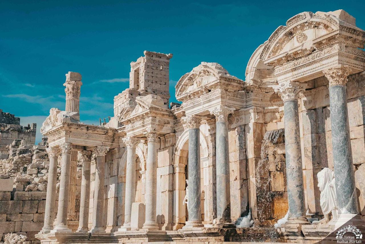
Antoninler Çeşmesi, Sagalassos Antik Kenti (https://www.kulturportali.gov.tr/turkiye/burdur/gezilecekyer/sagalassos-antik-kenti)
After the 1071 Battle of Manzikert, the Seljuk Turks began spreading across Anatolia, and Burdur was incorporated into Seljuk territories around 1075. As the Seljuk state weakened, the region came under the control of the Hamitoğulları Beylik and was annexed to the Ottoman Empire in 1391 during the reign of Yıldırım Bayezid. Under Ottoman rule, Burdur became an important center along trade routes and experienced economic growth, particularly in tanning and textile production.
In the late Ottoman period, Burdur became a district center in the 19th century and was attached to the Konya Vilayet. The city was severely damaged by a major earthquake in 1914 and briefly occupied by Italian forces between 1919 and 1921. However, after the War of Independence, it was reintegrated into the territory of the Republic of Türkiye. With the proclamation of the Republic in 1923, Burdur attained provincial status and has since become a city noted for its developing industry, cultural heritage, and natural beauty.
Burdur is located in the southwestern part of Türkiye, within the inland areas of the Mediterranean Region. Situated within the Lakes Region, Burdur forms a transition zone between the Mediterranean, Aegean, and Inner Anatolia Regions. The city is bordered by Isparta and Afyon to the east, Antalya to the south, Denizli and Muğla to the west. Burdur covers an area of 6,883 km² and has an average elevation of 950 meters.
Burdur’s surface features consist of mountains, plains, and highlands. Of the province’s terrain, 60.6% is mountainous, 19% consists of plains, 17.6% is rugged, and 2.7% comprises highlands. The city is surrounded by extensions of the Western Taurus Mountains: to the south by Boncuk Mountains, Elmalı Mountain, and Katrancık Mountain; to the east by Kuyucak and Dedegöl Mountains; to the north by Burdur Lake and Karakuş Mountain; and to the west by Acıgöl and Eşeler Mountains.
The highest mountain in Burdur is Kızılca Mountain, with an elevation of 2,598 meters. Other significant elevations include Akdağ at 2,276 meters, Kestel Mountain at 2,336 meters, and Eşeler Mountains at 2,254 meters.
The flat areas of Burdur are primarily located along lake shores and plains. The agriculturally significant plains of Bucak, Tefenni, Gölhisar, and Yeşilova are notable for their fertile soil structure.
Highlands occupy a wide area in the province. With elevations ranging from 1,200 to 2,200 meters, these highlands serve as important areas for animal husbandry. Areas such as Aziziye, Akdağ, Kırkpınar, Koca Yayla, and Eşeler Yaylası are known for their traditional highland pastoral culture.
Although Burdur lacks major rivers, it has numerous small streams and creeks. Most of these watercourses feed the lakes. The most important rivers are:
In addition, numerous smaller creeks such as Askeriye Creek, Çeltikçi Creek, Salda Creek, Armut Creek, and Tefenni Karamanlı Creek play a significant role in the region’s irrigation network.
Burdur, located within the Lakes Region, is home to numerous natural lakes. These lakes enhance ecological diversity and contribute significantly to the region’s natural beauty. The most important lakes in Burdur are:
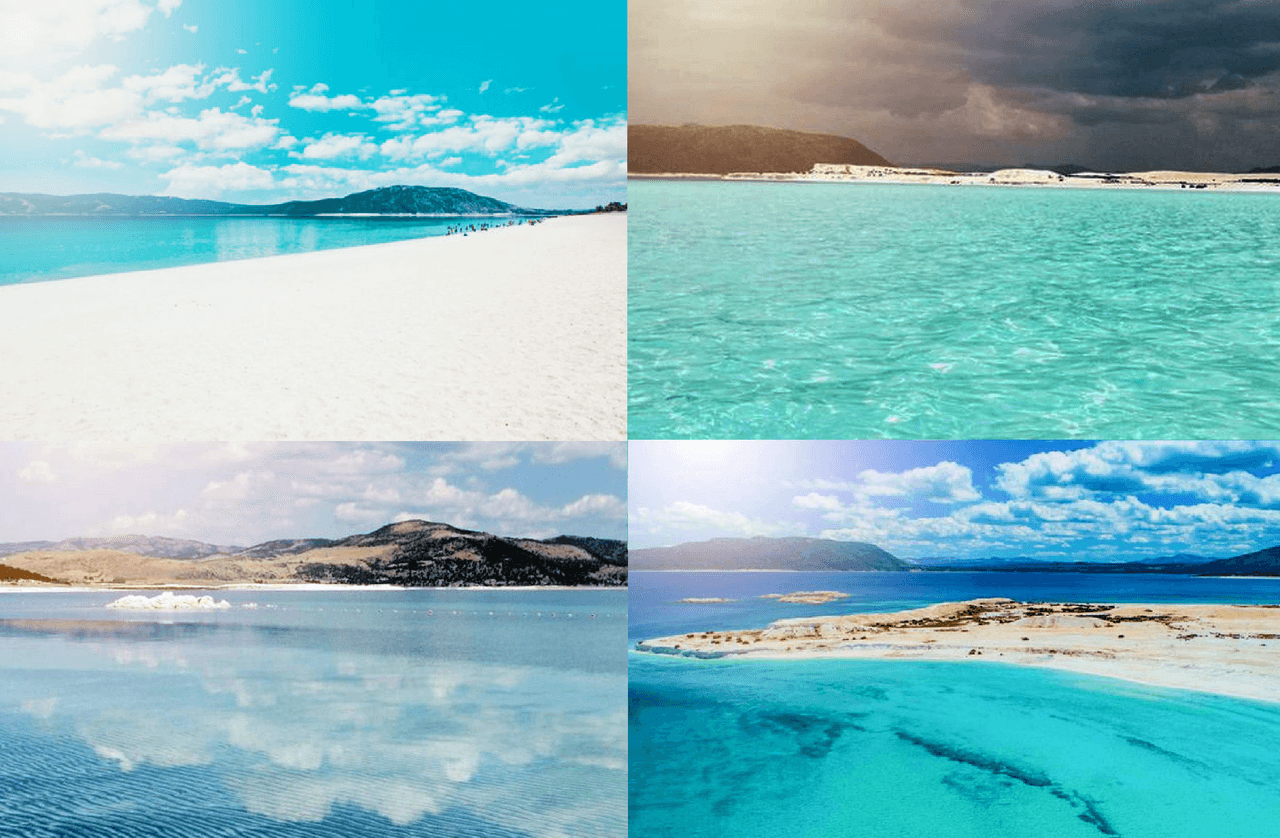
Salda Gölü (https://saldagolu.gov.tr/saldagolu/galeri.html)
Burdur’s lakes not only serve as vital water sources but also play a crucial role in maintaining the region’s ecological balance and tourism potential. Particularly Burdur and Salda Lakes are major attractions for both local residents and tourists.
Although Burdur is located within the Mediterranean Region, its elevation and position give it transitional characteristics between Mediterranean and continental climates. Generally, summers are hot and dry, while winters are cold and rainy.
Burdur’s high elevation results in lower temperatures compared to coastal areas. During summer months, temperatures can reach 30–35°C, while in winter they often fall below 0°C. Snowfall occurs occasionally during winter.
Precipitation patterns are irregular, with an annual average rainfall of 400–600 mm. The highest rainfall occurs in winter and spring, while summer months are typically dry. Burdur Lake and other water sources play a vital role in the region’s climatic balance. Additionally, due to its mountainous topography, local climate variations are observed, with higher elevations experiencing lower temperatures and greater precipitation.
As Burdur lies in the transition zone between Mediterranean and continental climates, its vegetation reflects characteristics of both. Generally, the province features forested areas, maquis communities, and steppe vegetation.
Burdur’s topography and climate conditions have enabled the development of forested areas in certain regions. Forests are concentrated mainly in higher elevations, where rugged and mountainous terrain dominates. Approximately 30% of the province’s land is covered by forests. Common tree species include:
In Burdur’s lowland areas and around lakes, maquis communities are shaped by Mediterranean climate influences. These areas are dominated by low shrubs and bushes. Common maquis species include:
In the plains and plateaus of Burdur, steppe vegetation dominates. Due to irregular rainfall and prolonged summer droughts, drought-resistant herbaceous plants and low shrubs are prevalent. Common species in these areas include astragalus (Astragalus spp.), oregano (Thymus spp.), wormwood (Artemisia spp.), and spurge (Euphorbia spp.).
Due to its diverse ecological conditions, Burdur hosts several endemic and rare plant species. Particularly in Tefenni, Altınyayla (Dirmil), and the Lakes Region, botanists have identified significant plant species. Some of these include:
Burdur’s vegetation, shaped by its lakes and mountains, exhibits great diversity. The natural vegetation, interwoven with agriculture and animal husbandry, significantly influences the province’s economic and ecological structure.
Burdur supports a rich natural habitat due to its lakes, mountains, and forested areas. Its geographical position as a transition zone between the Mediterranean and Inner Anatolia Regions enables the coexistence of diverse ecosystems, fostering a wide variety of wildlife.
Burdur is particularly significant for birdwatching. Wetland areas such as Burdur Lake, Salda Lake, and Yarışlı Lake serve as vital resting and feeding grounds for migratory birds. Burdur Lake is a habitat for the endangered white-headed duck (Oxyura leucocephala) and is recognized internationally as one of the most important bird areas.
Major bird species observed in Burdur include:
These bird species are primarily observed around wetlands, with some residing year-round and others visiting during migration periods.
Various mammal species inhabit Burdur’s forested and mountainous areas, particularly in higher elevations and rural regions where wildlife is abundant. Major mammals found in the province include:
These species primarily inhabit forested and mountainous areas. Predators such as the wolf, jackal, and fox play a vital role in maintaining the balance of wildlife.
Reptile species are common in Burdur’s hot and dry areas, particularly in rocky and shrubland habitats. Common species include:
Around wetlands, various frog and newt species are found. Species such as the grass snake (Natrix natrix) are also present around Salda Lake and Burdur Lake.
Several areas in Burdur have been designated as protected zones to conserve its rich fauna. These areas are of great importance for maintaining ecological balance and protecting endangered species. Major wildlife protection areas include:
These areas have been established to protect habitats of wild goats, raptors, and waterfowl.
Burdur’s fauna exhibits significant biological diversity thanks to wetlands provided by its lakes and natural habitats formed by mountains and forests. This richness enhances the region’s ecological importance and makes it an attractive destination for wildlife observers.
Burdur’s population has undergone various changes throughout history due to multiple factors. According to 2024 data, the province’s total population is 275,826. The majority of the population resides in urban centers and districts, while the rural population is gradually declining.
Burdur covers an area of 6,883 km² with a population density of approximately 40 people/km², which is lower than the national average. The population is relatively evenly distributed across districts, although Bucak district is the most populous.
The main districts of Burdur and their approximate populations are:
Regarding migration, it is known that during the early 20th century, immigrants from the Balkans and Caucasus settled in the region.
Burdur is one of the provinces with a relatively high education level, and its youth population ratio is slightly below the national average. While population growth is low in rural areas dependent on agriculture and animal husbandry, higher population concentration is observed in districts and the central city where industry and services have developed.
In recent years, Burdur has been among the provinces experiencing net population outflow. Particularly the youth population migrates to large cities due to educational and employment opportunities. Burdur residents moving to cities such as Istanbul, Antalya, İzmir, and Ankara have caused demographic shifts in the province. However, during summer and holiday seasons, temporary population increases occur due to the attraction of tourist sites such as Salda Lake.
Burdur’s population structure continues to evolve under the influence of economic, geographic, and sociocultural factors. Developments in industry and education will be key factors determining future population distribution and growth rates.
Burdur’s economy is based on agriculture, animal husbandry, industry, and mining. Its geographical location and climatic conditions are key factors shaping its economic structure. Burdur is a city with economic diversity, combining traditional agriculture and animal husbandry with a growing industrial sector.
Although Burdur does not have extensive agricultural land, agricultural production in its irrigated plains is a vital source of livelihood. Major agricultural products in the province include:
Burdur is one of Türkiye’s most important centers for rose and lavender production. Alongside Isparta, the region’s rose cultivation and rose oil industry hold a significant place in the provincial economy.
Animal husbandry plays a vital role in Burdur’s economic structure. Both small and large livestock farming are widespread, making the region one of the country’s key centers for milk and meat production. Burdur is among Türkiye’s provinces with the highest milk yield, thanks to its dairy production and processing facilities. Additionally, Burdur cheese and dairy products hold an important position in the regional economy.
The industrial sector is one of Burdur’s growing economic areas. Particularly the marble and stone processing industry is among the province’s most important industrial activities. Burdur is one of Türkiye’s largest marble production centers, with numerous marble quarries throughout the province. The marble extracted from Burdur is exported both domestically and internationally.
Burdur’s main industrial sectors include:
The Burdur Sugar Factory is one of the province’s largest industrial establishments. In addition, flour mills, animal feed plants, and food processing facilities are also present in the province.
The trade sector in Burdur has developed in relation to industry and agricultural production. Particularly trade in animal feed and dairy products based on animal husbandry is widespread. Burdur expands its economic activities by establishing commercial links with neighboring large cities. Its proximity to Antalya, Isparta, and Denizli contributes to increasing its trade volume.
The tourism sector is also gaining increasing importance in Burdur’s economy. Salda Lake, Sagalassos Ancient City, and the Burdur Archaeology Museum are key factors driving tourism revenue. Particularly in terms of nature and cultural tourism, Burdur is attracting increasing interest from both domestic and international tourists.
While Burdur’s economy remains based on industry and agriculture, it has diversified in recent years with the growth of tourism and services. Organized industrial zones and marble processing facilities are key drivers of the province’s economic growth. In the coming years, modernization of agricultural production, increased industrial investment, and developments in tourism are expected to further strengthen Burdur’s economy.
Burdur possesses significant tourism potential due to its natural beauty, historical heritage, and cultural values. Its location within the Lakes Region, its hosting of ancient cities, and its suitability for nature tourism make it an attractive tourist destination. In recent years, tourism has rapidly developed, particularly due to attractions such as Salda Lake and Sagalassos Ancient City.
Burdur stands out for its natural beauty. With its lakes, highlands, and mountains, it is a major center for nature tourism. Particularly due to its location within the Lakes Region, birdwatching and nature hiking are popular activities.
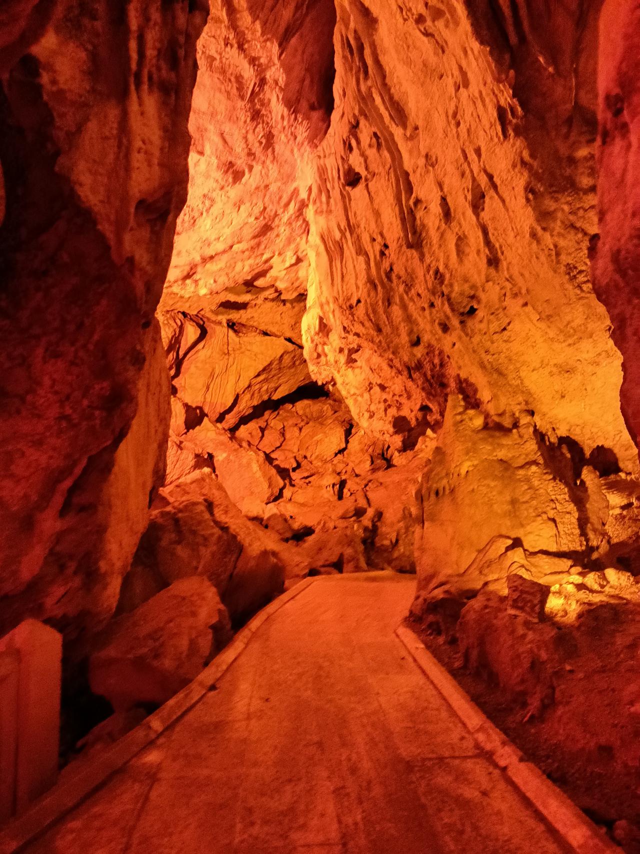
İnsuyu Mağarası (Fotoğraf: Meryem Şentürk Çoban)
Burdur has been home to numerous civilizations from antiquity to the present. The ancient cities in the region make Burdur a rich destination for historical and cultural tourism.
Burdur also attracts attention through its unique cultural values. Local folk dances, handicrafts, and cuisine enhance the province’s tourist appeal.
The Mayor of Burdur is Ali Orkun ERCENGİZ and the Governor of Burdur is Tülay BAYDAR BİLGİHAN.
The districts of Burdur are:
T.C. Burdur Valiliği Resmi İnternet Sayfası. Accessed February 14, 2025.http://www.burdur.gov.tr/
T.C. Ministry of Culture and TourismBurdur İl Directorate of Culture and Tourism Official Website. Accessed February 14, 2025.https://burdur.ktb.gov.tr/TR-70043/genel-bilgiler.html
T.C.Burdur Belediye Official Website. Accessed February 14, 2025.https://burdur.bel.tr/
Tuncel, Metin. "Burdur." *Türkiye Diyanet Vakfı İslâm Ansiklopedisi*. Accessed February 14, 2025.https://islamansiklopedisi.org.tr/burdur
Türkiye Kültür Portalı. "Sagalassos Antik Kenti-Burdur." Accessed February 14, 2025.
Türkiye İstatistik Institute Official Website. "Burdur." Accessed [Date].https://cip.tuik.gov.tr/
Burdur
Country | Türkiye | ||||||||
|---|---|---|---|---|---|---|---|---|---|
Region | Mediterranean | ||||||||
Population (Number) | 275826 | ||||||||
Area | 6883 km² | ||||||||
Elevation | 950 m | ||||||||
Climate | Continental climate and Mediterranean climate | ||||||||
Important Structure | Sagalassos Ancient City İnsuyu Cave | ||||||||
Governor | Tülay Baydar Bilgihan | ||||||||
Mayor | Ali Orkun Ercengiz | ||||||||
Area Code | 248 | ||||||||
License Plate Code | 15 | ||||||||
History
Geography
Landforms
Rivers
Lakes
Climate
Vegetation
Forested Areas
Maquis and Steppe Vegetation
Endemic and Rare Plants
Fauna
Bird Species
Mammals
Reptiles and Amphibians
Protected Areas and Wildlife
Population
Population Distribution and Density
Demographic Structure
Migration Trends
Economy
Agriculture and Animal Husbandry
Industry and Mining
Trade and Service Sector
Economic Development and Future Projections
Culture and Tourism
Nature and Ecotourism
Historical and Cultural Tourism
Cultural and Traditional Tourism
Administrative Structure
Districts