


This article was automatically translated from the original Turkish version.
+1 More
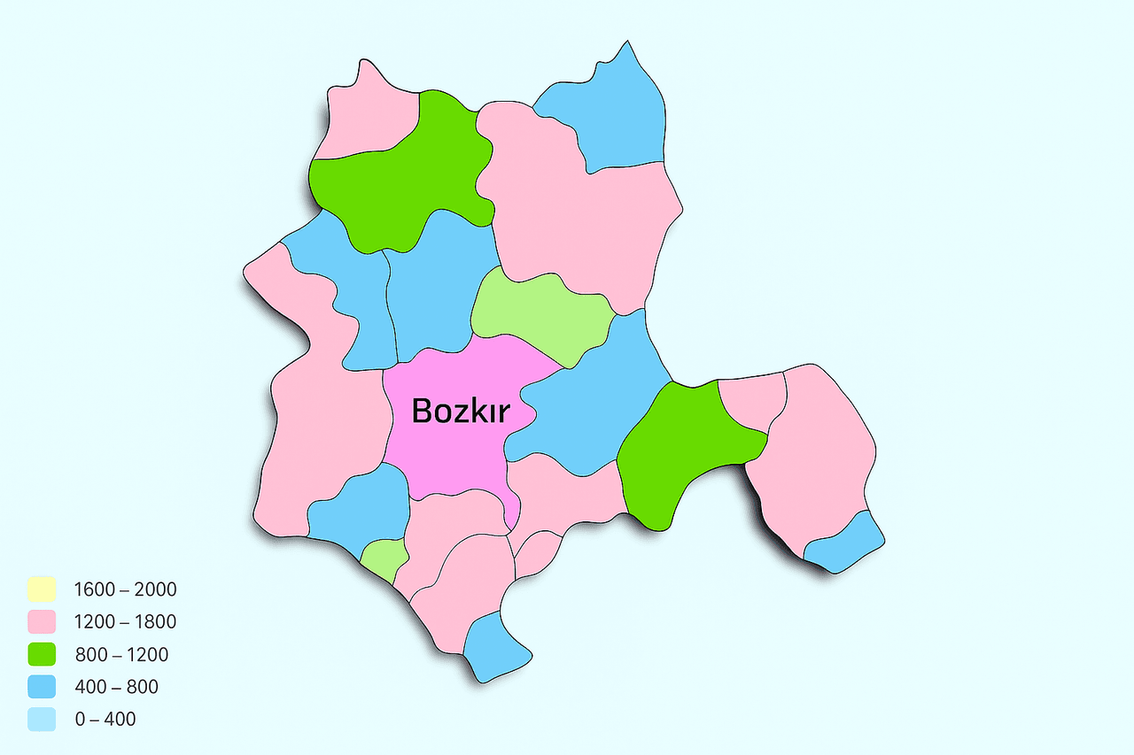
Bozkır (District)
Local Name | Steppe | ||||||||
|---|---|---|---|---|---|---|---|---|---|
Location | Konya Türkiye | ||||||||
Area | 1320 square kilometers | ||||||||
Elevation | 1200 | ||||||||
Population | 25.199 (TÜİK-2024) | ||||||||
Postal Code | 42630 | ||||||||
License Plate Code | 42 | ||||||||
Area Code | 0332 | ||||||||
Administrative Structure | District (attached to Konya Province), 52 neighborhoods | ||||||||
Climate | Continental | ||||||||
Neighboring Districts | Hadim, Ahırlı, Yalıhüyük, Güneysınır, Seydişehir | ||||||||
Bozkır, is a district located in the southern part of Konya Province within Türkiye’s Central Anatolia Region. Geographically, it borders the interior areas of the Mediterranean Region and features a mountainous and rugged terrain surrounded by extensions of the Taurus Mountains. It is approximately 116 kilometers from the provincial center and lies at an average elevation of 1,200 meters above sea level. This altitude contributes to the prevalence of a continental climate alongside a high-altitude plateau climate. The district is rich in natural vegetation, notable for its juniper, cedar, and black pine forests.
Administratively composed of 52 neighborhoods, Bozkır has maintained continuity in economic activities such as agriculture, small-scale livestock farming, and traditional crafts due to its historical position along Konya’s southern corridor. Although the district derives its name from the term “bozkır,” referring to the vast open plains in its surroundings, its topography is predominantly mountainous and plateau-like.
Table on the Neighborhoods of Bozkır
Bozkır and its surroundings have historically been among the oldest inhabited areas of Anatolia. Archaeological findings indicate human settlement in the region dating back to the 6th millennium BCE, during the Neolithic period. These early settlement traces reveal that Bozkır has served as a home to numerous civilizations throughout history. In antiquity, Bozkır and its environs lay at the heart of a region known as Isauria. The district’s earliest known name, Isaura Vetus (Old Isaura), refers to one of the most important cities of that era. Remains of this ancient city are situated on a strategic elevation now called Zengibar Castle, which functioned as both a military and administrative center. The name “Zengibar” is thought to derive etymologically from the words “Zen” (high) and “gibar” (castle).
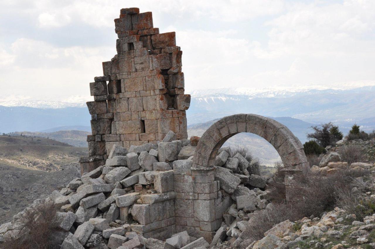
Zengibar Castle (Konya Bozkır District National Education Directorate)
The region was successively controlled during historical periods by the Hittites, Persians, and Hellenistic kingdoms. In the 1st century BCE, King Amyntas of Galatia incorporated Isauria into the Roman Empire. Following Amyntas’s death, the region came directly under Roman rule and attained provincial status. From this point onward, the region’s political and administrative structure became integrated into the central governance system of Rome, and the name Isauria emerged as a prominent regional identity in ancient sources.
After the Roman Empire split into Eastern and Western halves in 395 CE, Bozkır and its surroundings came under the control of the Eastern Roman Empire, known as Byzantium. During this period, the region was referred to in ancient sources as Leontopolis, a Greek term meaning “City of Lions.” This name likely arose due to the region’s mountainous terrain, its inaccessibility, and its formidable defensive castle systems. The designation also served as a metaphor for the local population’s warrior character and the area’s strategic military identity.
During the Byzantine era, Bozkır became an important center both administratively and militarily. Natural defensive advantages provided by structures such as Zengibar Castle facilitated Byzantine control over the region. It is also believed that Christianization intensified during this period, leading to the development of religious buildings and episcopal centers. The name Leontopolis remains one of the historical imprints left by this era in the region’s collective memory.
Following the Battle of Manzikert in 1071, Bozkır and its surroundings came under Seljuk control. The region’s strategic location and subterranean resources—particularly lead and lead-zinc mines—drew the attention of the Seljuks. During this period, Bozkır experienced economic and artisanal development. Local sources and oral traditions indicate that the area was known by names such as “Sırıstat,” “Sırıstad,” or “Seriustat” during this time.
Various interpretations exist regarding the origins of these names. One suggests that the phrase “Seri Usta” (Master Craftsman) gradually evolved in vernacular speech to become the region’s name, reflecting the abundance of skilled miners and artisans in the area. Another interpretation analyzes the term as “Sır-ı Usta,” implying that the name conveys technical knowledge and artisanal secrets related to mining. Both interpretations are noteworthy as they indicate that Bozkır was not merely a settlement but had transformed into a center of knowledge and production during this period. Furthermore, the region retained its importance during the Beylik Period following the decline of the Anatolian Seljuk State; although control shifted among local powers, mining and artisanal traditions continued uninterrupted.
During the Ottoman period, the physical geography of the region played a decisive role in place naming. Due to its expansive, treeless landscape dominated by grasslands, the area came to be known as “Bozkır.” This name not only reflects its physical appearance but also points to the nature of rural life and livelihood. In Ottoman archives, Bozkır is recorded not merely as a settlement but as a kaza—an administrative subdivision—recognized for its mines, livestock farming, and agricultural production.
The exploitation of mines containing lead and silver strengthened the region’s economic profile. These mines were also considered strategic resources by the state. One of the periods when Bozkır’s administrative importance increased was during the reign of Sultan Abdülmecid. During this time, Bozkır was granted the status of a sanjak, becoming an officially recognized center with its own flag. The fact that this sanjak’s banner is currently exhibited at the Konya Mevlana Museum highlights both the region’s historical value and its archival continuity. This position within the Ottoman administrative system demonstrates that Bozkır was recognized not only economically but also culturally and symbolically.
With the proclamation of the Republic of Türkiye, Bozkır became part of the newly restructured administrative system. However, this transition brought not only bureaucratic changes but also social and ideological fractures. The Bozkır Uprisings of 1920–1921 exemplify these tensions.
At the core of the uprising was the role played by Zeynel Abidin Efendi and his family, who had been sent to the region during the final years of the Ottoman Empire as religious guides and who wielded strong influence over the local population. This group was pivotal in the tensions between central authority and local religious leadership. The demand for a legal order based on Sharia law directly contradicted the Republic’s secularization goals. However, the uprising did not represent the entire population of Bozkır; a significant portion of the local populace remained distant from the movement and preferred to align with the Republican administration.
Ultimately, the uprising was swiftly suppressed through military intervention, and order was restored. This event is recorded as one of the most turbulent periods in Bozkır’s integration into modern Türkiye. In the years that followed, Bozkır transformed into a district aligned with central administration, benefiting from Republican reforms in education, health, and infrastructure.
Today, Bozkır stands out as one of Konya’s districts notable for both its cultural heritage and rural production. Having hosted various civilizations throughout history, the district attracts attention through its archaeological sites. Excavations around Zengibar Castle have uncovered significant remains from the Hellenistic and Roman periods. In this regard, Bozkır has become a center of interest not only for history enthusiasts but also for academic circles and those involved in tourism.
Zengibar Castle, with its architectural structure and strategic location, is referred to as “Konya’s Ephesus.” Meanwhile, Bozkır maintains a vibrant local economy based on agriculture and livestock farming. In addition to staple crops such as barley, wheat, and chickpeas, small-scale livestock farming and beekeeping are widespread. Furthermore, traditional crafts such as woodworking, weaving, and stonemasonry continue to be practiced and contribute to the local economy. In this way, Bozkır endures as both a historical heritage site and a productive Anatolian district.
Located within the boundaries of Bozkır District in Konya Province, Zengibar Castle is situated at an elevation of 1,800 meters near the summit of Asar Mountain. The castle was built atop the ancient settlement known as Isaura Vetus. This confirms that the structure is not merely a medieval fortress but a multi-layered archaeological site.
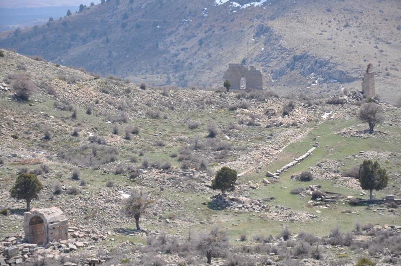
Zengibar Castle (Bozkır Municipality)
The area where the castle stands lies at the heart of the mountainous region known in antiquity as Isauria. Settlement history extends back to the 1st millennium BCE. The site is believed to have been used during the Hittite, Persian, Roman, and Byzantine periods, with particularly notable architectural remains from the Roman era. Research in the area has uncovered defensive walls, paved stone roads, water cisterns, and public buildings. These structures reveal both the strategic defensive function of the settlement and its civil architectural features.
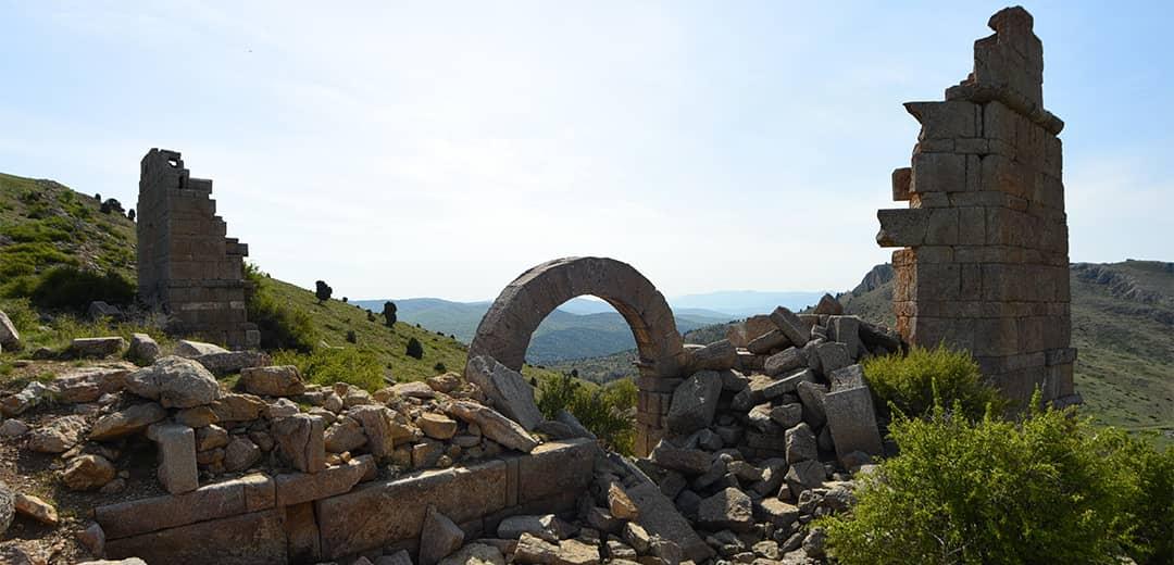
Zengibar Castle (Go Konya, Konya Metropolitan Municipality)
Surface surveys and archaeological excavations at Zengibar Castle and its surroundings are of great importance for understanding the region’s historical geography and urban development. The settlement serves as a key source for studying regional power struggles, defensive architecture, and Roman stonemasonry.
The mosque located in Hisarlık Neighborhood of Bozkır District, Konya Province, is dated to the late 13th century based on an inscription from 1282. The structure exhibits architectural features characteristic of the late Seljuk and early Ottoman periods.
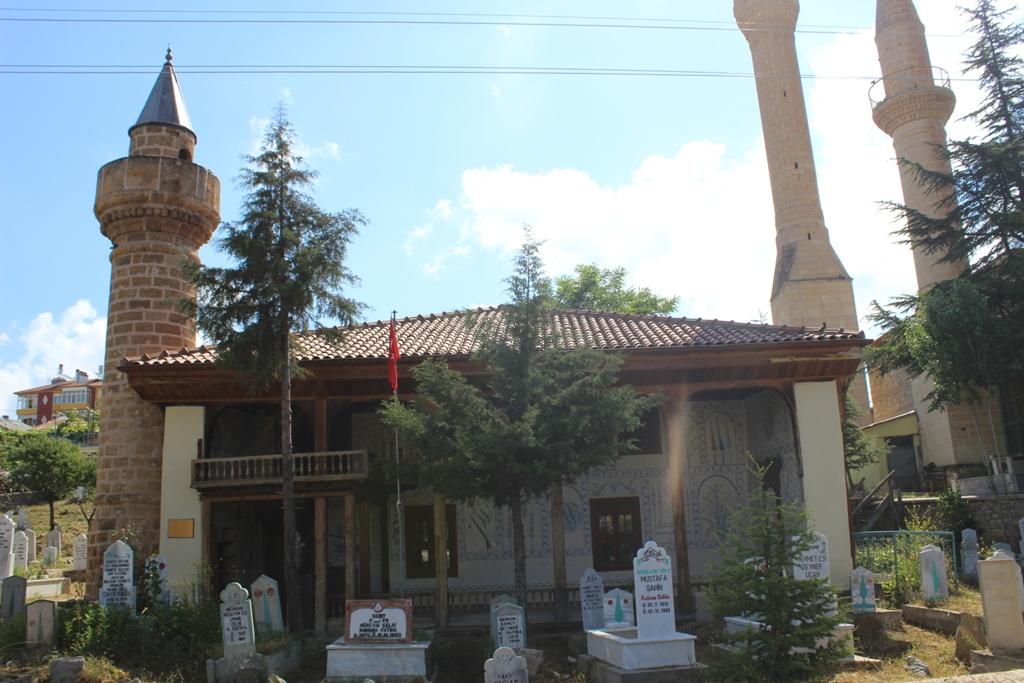
Hisarlık Mosque Exterior (Bozkır Municipality)
Wood is prominently used in the mosque’s architecture. The wooden craftsmanship on the ceiling and minbar is particularly noteworthy for reflecting the artistic sensibilities of the period. The limited number of fresco-like decorations inside the space are considered a rare feature among mosques in the region.
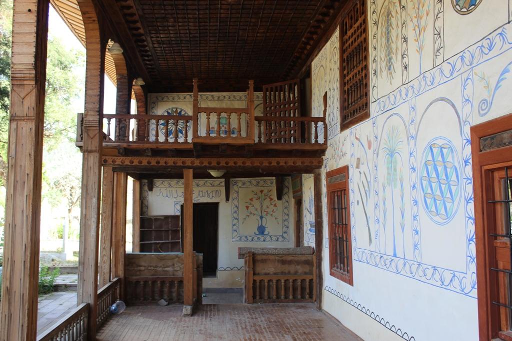
Hisarlık Mosque Courtyard (Bozkır Municipality)
The structure has been registered in the inventory of the Ministry of Culture and Tourism as a “Protected Immovable Cultural Asset.” It holds a place among the region’s historical buildings due to its demonstration of continuity in religious architecture and its inclusion of original elements documenting local artistic production.
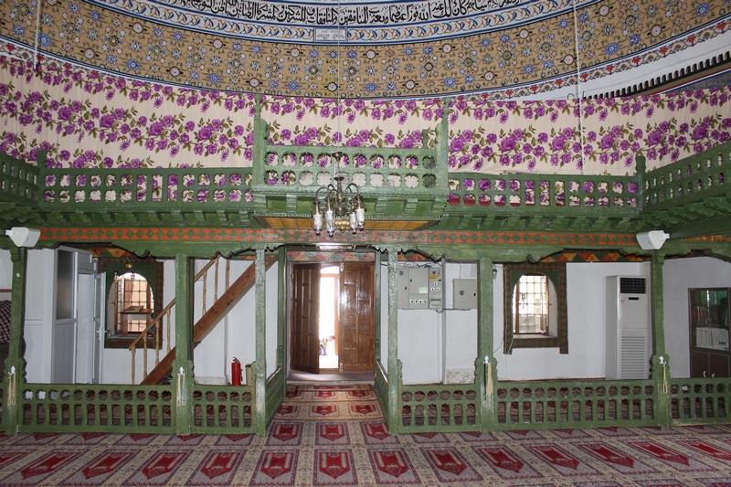
Hisarlık Mosque Interior (Bozkır Municipality)
Located in Üçpınar Neighborhood of Bozkır District, Konya Province, the mosque is dated to 1816 based on inscriptions and oral sources. The structure acquired its popular name “Kurşunlu Camii” (Lead-Covered Mosque) due to the lead cladding on the exterior surface of its main dome.
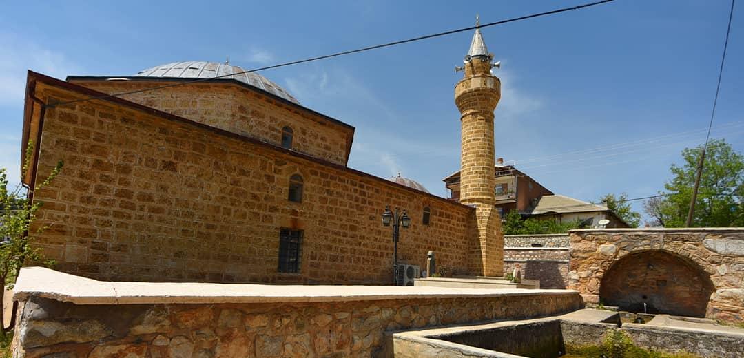
Üçpınar Lead-Covered Mosque Exterior - Go Konya, Konya Metropolitan Municipality
The mosque’s plan resembles classical Ottoman mosque architecture, with its central dome being particularly distinctive. The exterior facade adopts a simple architectural style, while decorative elements inside are applied sparingly. The use of lead cladding was chosen both to enhance structural durability and to provide protection against climatic conditions.
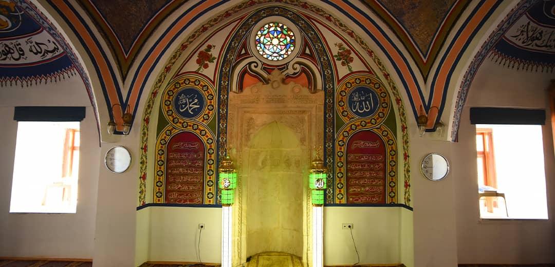
Üçpınar Lead-Covered Mosque Interior (Go Konya, Konya Metropolitan Municipality)
The mosque remains open for worship and is preserved as part of the local cultural heritage. It is regarded as one of the representative examples of rural religious architecture from the late Ottoman period.
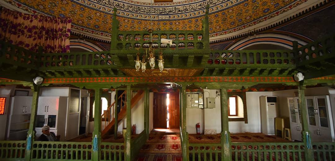
Üçpınar Lead-Covered Mosque Interior (Go Konya, Konya Metropolitan Municipality)
Located within the boundaries of Bozkır District over the Çarşamba Stream, the stone bridge exhibits architectural features and construction techniques similar to 13th-century Seljuk-era works. The bridge has a total length of 21 meters and a width of 3.85 meters. Constructed from cut stone, it features a single pointed arch.
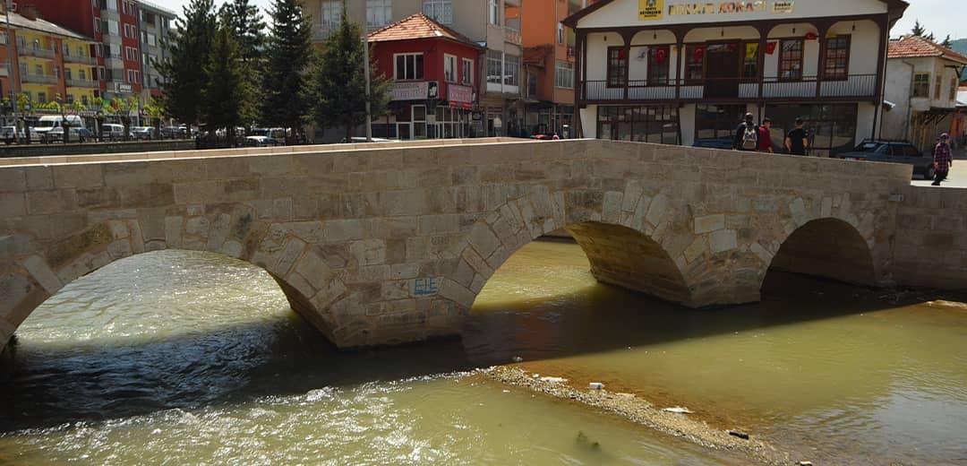
Çarşamba Bridge (Go Konya, Konya Metropolitan Municipality)
Historically, the bridge ensured continuity of transportation and trade in the region, serving as a vital transit point between Bozkır and surrounding settlements. It was restored in 2016 under the supervision of the General Directorate of Monuments and Museums and is currently registered as a “Protected Immovable Cultural Asset.”
Bozkır, as a district of Konya Province, hosts various government institutions that ensure the effective delivery of public services at the local level. Below is a list of the main government institutions located in Bozkır District.
Selçuk University Bozkır Vocational School
Anatolian High Schools
Vocational and Technical Anatolian High Schools
The table below presents the population changes in Bozkır District from 1965 to 2024.
Population Changes in Bozkır by Year
Anadolu Ajansı. "Isaura Antik Kentinin Sırları Gün Yüzüne Çıkartılmayı Bekliyor." Accessed May 31, 2025.https://www.aa.com.tr/tr/kultur-sanat/isaura-antik-kentinin-sirlari-gun-yuzune-cikartilmayi-bekliyor/1882613.
Bozkır Belediyesi. "Tarihçe." Accessed May 31, 2025.https://www.bozkir.bel.tr/icerik/tarihce
Bozkır Kaymakamlığı. "Tarihi Selçuklu Köprüsü." Accessed May 31, 2025.http://www.bozkir.gov.tr/tarihi-selcuklu-koprusu.
Bozkırlılar Derneği. "Bozkır Tarihi." Accessed May 31, 2025.https://bozder.bozkir.org.tr/2010/10/bozkr-tarihi.html.
Doğanay, Osman, ed. *Zengibar Kalesi Araştırmaları - 2.* Arkeoloji ve Sanat Yayınları, Istanbul, 2023. Accessed May 31, 2025.https://www.researchgate.net/publication/378031508_Zengibar_Kalesi_Arastirmalari_2
GoKonya Tanıtım Promotion Platform). "Bozkır İlçesi." Accessed May 31, 2025.https://gokonya.com/tr/bozkir.
Nüfusu.com. "Bozkır Nüfusu." Accessed May 31, 2025.https://www.nufusu.com/ilce/bozkir_konya-nufusu.
T.C. Ministry of National Education,Bozkır İlçe National Education Directorate. "Bozkır Tarihi." Accessed May 31, 2025.https://bozkir.meb.gov.tr/www/bozkir-tarihi/icerik/588
Turkiye İstatistik Kurumu (TÜİK). "Bölgesel İstatistikler." Accessed May 31, 2025.https://www.tuik.gov.tr/.

Bozkır (District)
Local Name | Steppe | ||||||||
|---|---|---|---|---|---|---|---|---|---|
Location | Konya Türkiye | ||||||||
Area | 1320 square kilometers | ||||||||
Elevation | 1200 | ||||||||
Population | 25.199 (TÜİK-2024) | ||||||||
Postal Code | 42630 | ||||||||
License Plate Code | 42 | ||||||||
Area Code | 0332 | ||||||||
Administrative Structure | District (attached to Konya Province), 52 neighborhoods | ||||||||
Climate | Continental | ||||||||
Neighboring Districts | Hadim, Ahırlı, Yalıhüyük, Güneysınır, Seydişehir | ||||||||
History
Byzantine Period: Leontopolis (City of Lions)
Seljuk and Beylik Periods
Ottoman Period: The Origin of the Name Bozkır
Early Republican Period and the Bozkır Uprisings
Bozkır Today
Historical and Tourist Sites
Zengibar Castle (Ancient City of Isaura)
Hisarlık Neighborhood Mosque
Üçpınar Lead-Covered Mosque
Historic Bozkır Çarşamba Bridge (Seljuk Bridge)
Government Institutions
Administrative Institutions
Judicial Institutions
Educational Institutions
Universities
High Schools
Middle Schools
Primary Schools
Health Institutions
Social Service Institutions
Other Institutions
Population