This article was automatically translated from the original Turkish version.
+1 More
Location | İznik District Bursa Province Selçuk Neighborhood | ||||||||
|---|---|---|---|---|---|---|---|---|---|
Distance from Shore | 50 m | ||||||||
Depth | 2-3 m | ||||||||
Main Findings | Glass vessel and lighting element fragments Coin groups Various tomb types Cross-shaped objects and bronze crosses with reliquary characteristics Ceramics Jewelry and clothing accessories Connecting elements Iron and bronze nails | ||||||||
Archaeologist Who Discovered the Area | Prof. Dr. Mustafa Şahin | ||||||||
Type | Site Area Three-aisled basilica | ||||||||
Functions | Saint Neophytos Martyrdom Site Necropolis area Early Christian period basilica | ||||||||
Width | Approximately 18.61 m | ||||||||
Historical Layers | Early and Middle Byzantine Late Antiquity Late Hellenistic – Early Roman Late Byzantine | ||||||||
North Aisle Width | Approximately 3.32 m | ||||||||
South Aisle Width | Approximately 3.15 m | ||||||||
Apse Diameter | Approximately 6.85 m | ||||||||
Length | Approximately 41.32 m | ||||||||
Central Aisle | Approximately 20.03 × 7.95 m | ||||||||
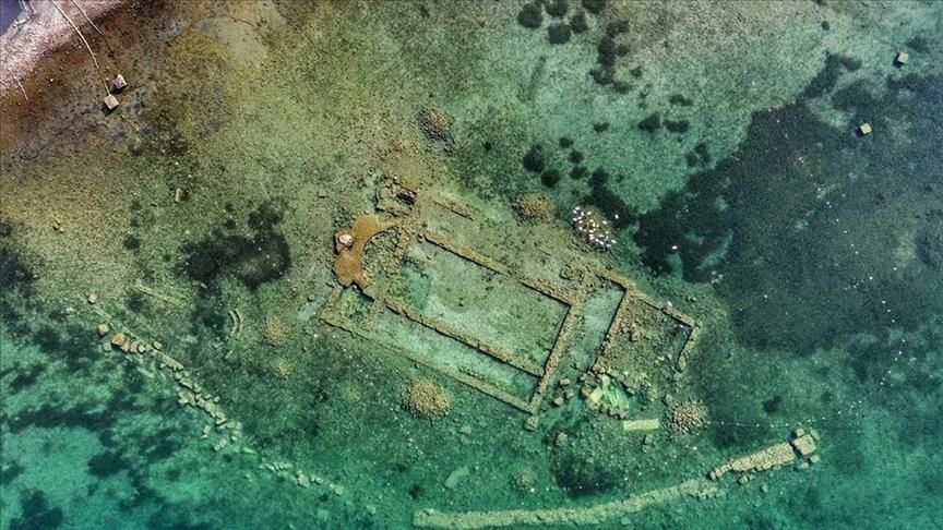
The İznik Basilica, is a submerged early Christian church of basilican plan, preserved underwater approximately 50 metres from the shore of Lake İznik and at a depth of 2–3 metres, within the boundaries of Selçuk neighbourhood, İznik district, Bursa Province. The structure lies just outside the lake-facing section of the ancient city walls of Nicaea, situated in the transitional zone between the city’s land walls and the lakeshore, aligned parallel to the shoreline. This positioning reveals that the building was directly integrated into both the urban layout and the topography of the lakeshore.
The remains were identified in February 2014 by Professor Dr. Mustafa Şahin during aerial photographic surveys conducted in İznik and its surroundings. Prominent wall traces on the lake surface, forming a rectangular shape parallel to the shore, prompted on-site verification; subsequently, underwater investigations were initiated under the authority of the Ministry of Culture and Tourism, on behalf of Uludağ University. Following the announcement of the discovery, various reports appeared in national and international media; the existence of a submerged basilica along the shores of Lake İznik emerged as a new research topic within the context of early Christian architecture and underwater archaeology.
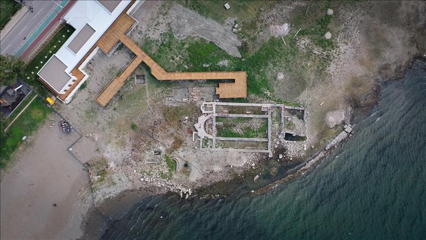
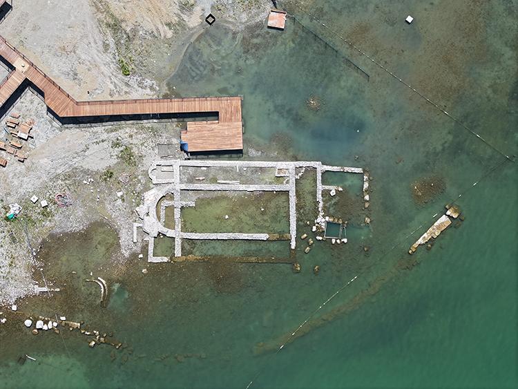
Current Condition of the İznik Basilica (Anadolu Ajansı)
The area where the remains are located is associated with the site where Saint Neophytos, believed to have been martyred in the early Christian period, suffered torture and death near the lakeshore. It is stated that after Christianity was officially permitted, a church dedicated to the saint was constructed in this area. Current archaeological evidence suggests that the underwater basilica may be linked to this tradition and could have functioned as a sacred site dedicated to Saint Neophytos.
Following the discovery, surface underwater surveys were conducted first, followed by systematic underwater excavations. Under the leadership of the İznik Museum Directorate and with scientific guidance from Uludağ University, floating platforms were established on the lake; specialized underwater archaeology equipment including diving operations, snuba systems, centrifugal pumps, and sieving units were employed. This enabled the controlled removal of sediment from the lakebed, in situ documentation of architectural remains, and detailed recording of small finds.
Research revealed that the basilica’s plan, nave arrangement, apse position, and associated architectural elements are largely traceable; additionally, coins, ceramics, and other small artifact groups recovered from the site have become primary sources for determining the building’s chronology and phases of use. The Lake İznik Basilica, through these characteristics, constitutes a critical example both for understanding the Christian-era topography of İznik and for the development of underwater archaeology practices in Türkiye.
The Lake İznik Basilica is situated on the northeast shoreline of Lake İznik, in the southeastern part of the Marmara Region, approximately 20–30 metres beyond the lakeside section of modern İznik’s defensive walls. The architectural remains extend parallel to the shore, averaging 50 metres from the current shoreline. In this section of the lake, depth varies between 2 and 3 metres; the calm and relatively shallow water allows the remains to be clearly visible on the lakebed.
Lake İznik formed on a tectonic depression. This depression, aligned parallel to the southern branch of the North Anatolian Fault, has undergone continuous geomorphological changes due to earthquakes throughout historical periods. The ancient settlement of Nicaea on the eastern shore was directly affected by this seismic activity; geological evidence supports that the lakeshore line advanced or retreated at different times during antiquity. Measurements of the lakebed indicate particularly significant sediment accumulation along the northeast shore, suggesting that the historical shoreline was likely located further inland than it is today.
The geomorphology of the area where the basilica is located is closely related to fluctuations in lake level and earthquake-induced subsidence. Chronologies of settlements around the lake and records in ancient sources indicate that the lake’s water level varied by at least several metres during historical periods.
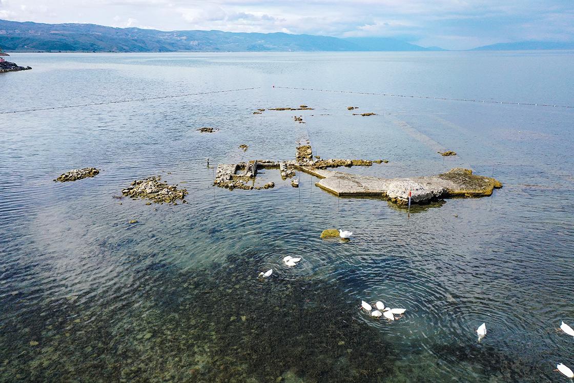
Close-up View of the İznik Basilica (Anadolu Ajansı)
The submergence of the basilica is likely linked to a powerful seismic event during the Late Antiquity or the Middle Ages. The earthquake of 740 CE, documented in Byzantine sources as having caused extensive destruction in Nicaea, is considered one of the primary events responsible for the building’s submersion under lake waters.
The hydrological structure of the lake’s surroundings also directly affects the preservation conditions of the remains. Lake İznik is a closed basin; there are no significant current systems beyond surface runoff from small streams and groundwater. Consequently, thick layers of mud and fine sediment accumulate on the lakebed, preserving the basilica’s wall fragments largely within this soft sediment layer. The sediment cover has surrounded most of the wall masonry, slowing erosion and contributing significantly to the relatively good state of preservation of the remains for underwater archaeology.
Bathymetric measurements around the remains show that the lakebed gently slopes downward toward the northwest. This slope highlights the plateau-like shallow area where the structure is located. The irregular distribution of stone blocks farther from the building suggests that long-term water movement and microscopic landslides on the lakebed have partially altered the remains’ original positions.
From a natural environment perspective, the shoreline where the basilica is located corresponds to a point near the eastern gate of ancient Nicaea. It is presumed that a small harbor or pier structure existed where the road from this gate reached the lakeshore. In this context, the basilica’s proximity to the shore is argued to have had not only religious significance but also a connection to the city’s waterborne access. The location of this sacred structure in the northeastern sector of the lake marks a transitional zone between land and water routes within the urban topography of Nicaea.
The remains of the Lake İznik Basilica were identified in February 2014 during aerial photographic surveys led by Professor Dr. Mustafa Şahin. While documenting ancient settlement traces in İznik and its vicinity, a rectangular structure silhouette was noticed just beneath the lake surface near the shore; wall traces running parallel to the shoreline indicated the possible preservation of architectural remains on the lakebed. Subsequent on-site inspections confirmed the presence of foundation remains of a basilican church approximately 50 metres from the lakeshore and at a depth of 2–3 metres. In the same year, the American Archaeological Institute’s periodical Archaeology included these remains in its list of the “Top 10 Discoveries of 2014,” thereby registering the structure in international literature.
In the initial phase following the discovery, an underwater archaeological research project was launched under the authority of the Ministry of Culture and Tourism, on behalf of Uludağ University. The primary objectives during this period were to document the current condition of the remains, produce plans and profiles, and determine the preservation conditions of the structure on the lakebed. A floating platform was established on the lake; underwater diving operations allowed observation of wall traces, architectural blocks, and cultural fill surrounding the structure. Combined underwater photographic and video recordings with measurements enabled the establishment of the building’s general plan layout, and for the first time, detailed documentation of wall thicknesses, nave, apse, pastophoria, and nartex-atrium arrangements.
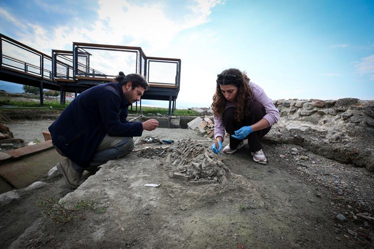
A Frame from Excavation Work (Anadolu Ajansı)
The 2015 season is highlighted as the period when systematic underwater excavations began. During this phase, controlled removal of sediment from the lakebed, stratigraphic excavation in selected trenches, and limited excavation to deeper levels within the nave and around the apse yielded the first archaeological stratigraphic data. These efforts enabled the study of the basilica not only at the plan level but also in terms of its phases of use; the recovery of coins, ceramics, and various small finds alongside architectural remains provided foundational evidence for discussing the building’s chronology.
The 2016 season was marked by an increase in both the scope and intensity of underwater excavations. Excavation reports from this season reveal the prominence of necropolis data in trenches opened in the naos and adjacent areas. A series of brick tombs were identified adjacent to and aligned with the southern wall of the nave; these tombs were numbered KM-01, KM-02, KM-03, etc. The excavation and documentation of these tombs demonstrated that the basilica functioned not only as a church but also as a burial ground, indicating that interior space and cemetery use were integrated within the same structural framework.
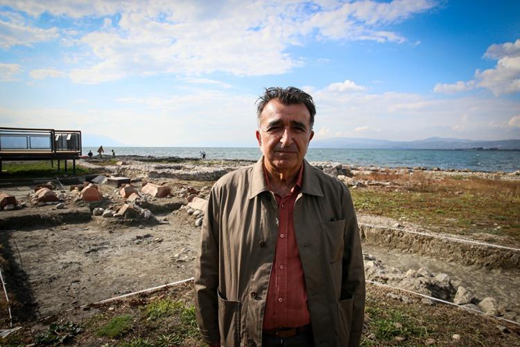
Professor Dr. Mustafa Şahin, Discoverer of the İznik Basilica (Anadolu Ajansı)
In subsequent years (2017 and 2018), underwater excavation and documentation work continued with new trenches opened both within the naos and around the apse and pastophoria. Reports indicate that findings such as the exposure of stylobat lines defining the nave divisions, identification of in situ column bases, and documentation of parapet slabs and opus sectile floor fragments clarified the building’s architectural design. During this period, observations regarding wall masonry, floor coverings, and tomb typologies began to accumulate, indicating different construction phases.
During the 2019 and 2020 seasons, intensive work was carried out in trench 12A, located particularly in the northeast sector of the basilica. Sediment on the lakebed was systematically removed using centrifugal pumps and sieving units down to elevations between –1.27 and –1.57 metres; during this process, a significant quantity of wooden fragments, nails, various metal finds, bronze coins, and ceramic sherds were recovered. In the same trench, fragments of human skulls were found beneath the stone fill, adding to the evidence suggesting that the area continued to be used for burial or secondary use in later periods.
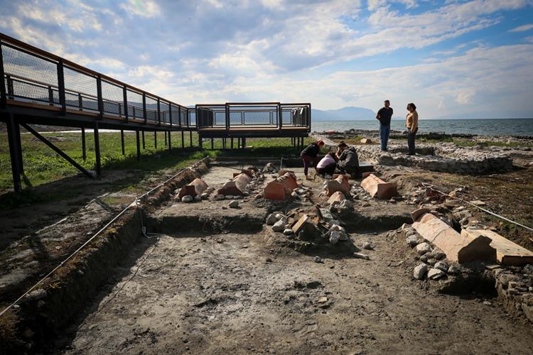
Excavation Work Around the Basilica (Anadolu Ajansı)
The 2021 season report marks a new phase in the excavation history. Under the authorization issued by the General Directorate of Cultural Heritage and Museums of the Ministry of Culture and Tourism on 18 May 2021, excavation leadership was assumed by the İznik Museum Directorate, under the responsibility of Ahmet Türkmenoğlu and museum expert Nazan Canverdi, with scientific support from Uludağ University, Bursa. The team included, alongside underwater archaeologists, researchers from other disciplines such as anthropologist Dr. Songül Alparslan-Rodenberg, endowing the excavation with an interdisciplinary character, particularly for the evaluation of anthropological and biological data. During this season, depth reduction work continued in previously identified trenches, and wooden elements and finds associated with tombs were documented.
Overall, each excavation season since the 2014 discovery and preliminary documentation has highlighted a different aspect of the structure. In the early years, the focus was on determining the plan layout and recording architectural remains; during the 2015 and 2016 seasons, internal burial practices and the necropolis area came to the fore; and during the 2019–2020 and 2021 seasons, deeper trenches revealed a complex history of use represented by wooden, metal, and human remains. Thus, the structure has been documented both as an early Christian basilica and as an underwater archaeological site characterized by long-term use and subsequent processes within the lake environment.
The Lake İznik Basilica features a three-nave basilican church plan oriented east-west. The central structure measures approximately 41.32 metres in length and 18.61 metres in width from exterior to exterior. The central nave is 20.03 metres long and 7.95 metres wide. The north nave is approximately 3.32 metres wide, while the south nave is 3.15 metres wide, indicating that the south nave is slightly narrower than the north nave. Wall thicknesses average around 1 metre.
At the eastern end of the naos, there is a main apse with a circular interior plan and a polygonal exterior wall form. The diameter of the apse is approximately 6.85 metres. On either side of the main apse are pastophoria chambers; the width of the southern chamber is recorded as approximately 4.06 metres. Initial assessments identified this space as a diaconicon, but excavations in 2017 revealed the presence of another apse within it. Within the southern pastophorion, a sarcophagus measuring 1.97 metres in length and 0.70 metres in width was found adjacent to the southern wall. Thus, at the eastern end, liturgical or monumental arrangements are evident not only in the main apse but also in the side chambers.
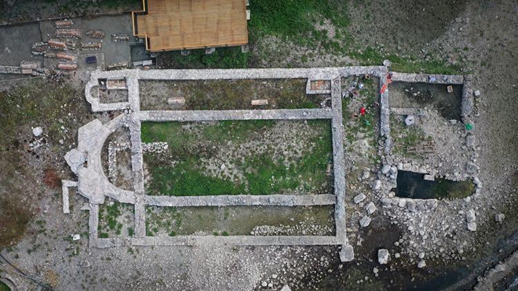
Architectural Structure of the İznik Basilica (Anadolu Ajansı)
To the west of the naos, a nartex and, in front of it, a three-unit atrium are arranged sequentially toward the western facade of the structure. The southern wall of the atrium is set slightly inward compared to the nartex wall. This arrangement produces a three-unit courtyard design on the western facade and a more dynamic facade design with a slightly recessed wall line on the south. The three-unit atrium indicates a layout emphasizing the central axis, with side sections related to entrance and circulation areas; the sequential positioning of the nartex and atrium creates a multi-layered entrance system on the basilica’s western facade.
The division of the interior space into naves was achieved through stylobates and rows of columns rising upon them. Excavations at the western end of the north stylobate yielded detailed data on the supporting system defining the nave division. After removal of the rubble fill, the stylobate plane was exposed at approximately +476 elevation; four column bases of Attica Type B were identified at the upper elevation of +506. It is understood that the spaces between the column bases were later closed with rubble stone walls. The slabs, slab bases, and upper fragments recovered from this area indicate that high parapet slabs were used to define the nave division, emphasizing the nave boundaries not only through column rows but also through vertical surfaces.
Two distinct types of column capitals were identified between the columns: Corinthian and Ionic–impost capitals. The use of different capital types within the same structure suggests that different supporting element types were preferred for the lower floor and a possible gallery level. The “high” arrangement of the nave division parallels solutions known in early Byzantine churches, both in terms of visual permeability between spaces and the overall structural design. On the north and south sides of the stylobate, at approximately +469 elevation, white limestone plaster coatings were identified; these coatings formed part of the high-quality floor covering material used in the naves.
Location Map of the Basilica (Anadolu Ajansı)
Opus sectile flooring is a significant architectural feature in the structure. In certain areas, large sectile pieces arranged diagonally intersecting, with smaller square and triangular pieces filling the gaps, form a geometric pattern. This arrangement, particularly in areas near the naos and nave divisions, can be interpreted as floor designs that reinforce spatial hierarchy. During excavation and documentation, these opus sectile floors were recorded using three-dimensional laser scanners and subsequently covered with geomembrane and fine sand layers for protection.
Overall, the architectural design of the Lake İznik Basilica is defined by a three-nave basilican plan, a circular interior and polygonal exterior main apse with adjacent pastophoria chambers at the east, a nartex–atrium ensemble at the west, stylobates and column rows defining the nave division, high parapet slabs, the use of two distinct types of column capitals, and rich opus sectile floorings. These architectural features demonstrate that the structure re-creates a classical basilican church schema within the specific topography of the Lake İznik shoreline, both in its dimensions and detailed interior layout.
The area where the Lake İznik Basilica is located appears not as a narrow parcel for the construction of a single church but as a broad cultural layer containing superimposed settlement and usage traces from different periods. Excavation trenches opened during underwater investigations reveal that both architectural remains and ceramic, coin, and small artifact groups allow the site’s chronology to be traced through several main phases.
The earliest finds beneath and around the basilica’s architectural remains on the lakebed indicate that the area was in use from the Late Hellenistic and Early Roman periods. In particular, in trench 12A opened in the atrium section, evidence dating to the 1st century BCE was recovered at a depth of approximately –1.97 metres. The discovery of a bronze coin minted in Prusa ad Olympum in the name of the proconsul of Bithynia–Pontus, C. Papirius Carbo, suggests that this lakeshore area was in use no later than around 62–59 BCE. Late Hellenistic ceramic fragments found at the same level confirm that this dating is not coincidental and indicate continuous activity in this sector from the 1st century BCE onward.
Although no architectural plan from this early phase has yet been identified, the coins and ceramics demonstrate that the lakeshore was used as a functional area connected to the city. Whether this area served as a pier, warehouse, workshop, or other function during this period remains unclear; however, the density of Hellenistic–Roman finds indicates that the location of the basilica was previously part of a shoreline zone integrated into the daily life of the city.
The earliest data pertaining to the basilica itself emerge from the combined analysis of architectural features and coins dated to the late 4th and early 5th centuries. The three-nave plan, the circular interior and polygonal exterior apse form, side chambers adjacent to the apse at the east, and the nartex–atrium sequence at the west are consistent with the classical basilican church typology of Late Antiquity. The column bases, parapet slabs, and opus sectile arrangements in the flooring indicate, both architecturally and decoratively, a period between the 4th and 5th centuries.
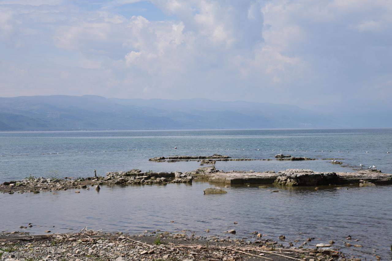
Close-up View of the İznik Basilica (Anadolu Ajansı)
Among the coins recovered within the naos and particularly in layers associated with tombs, examples from the reign of Emperor Valens (364–378 CE) indicate that the church was in use by at least the second half of the 4th century. When evaluated together with architectural features, these findings suggest a framework in which the basilica was likely constructed during the final quarter of the 4th century and early 5th century, following the official imperial acceptance of Christianity.
The assumption that the building is associated with the cult of Saint Neophytos is consistent with this chronology. According to Christian tradition, Neophytos, who was martyred at a young age, was killed near the lakeshore, and a church was later built in his honor at this location. This narrative supports placing the basilica’s initial construction phase within Late Antiquity, when martyr cults became widespread; however, no inscription or direct documentary evidence confirming this association has yet been identified.
Excavations have revealed interventions differing from the original masonry in terms of stone craftsmanship and binding material, including later-added walls and closures of certain openings. For example, a wall cutting across the stylobat line defining the nave division was constructed in a later phase. The partial filling of spaces between column bases with rubble stone suggests that the original nave division, defined by column rows, was later transformed into a more enclosed arrangement.
Such interventions demonstrate that the church was not abandoned shortly after its initial use but underwent repairs and reorganizations in different periods. Relationships between wall masonry, floor coverings, and tomb placements imply that new liturgical arrangements were introduced and the functions of certain spaces changed. The apse identified within one of the pastophoria chambers indicates that these side spaces were increasingly emphasized liturgically over time.
A detailed century-by-century chronology for these phases has not yet been fully established; however, evaluation of ceramic and coin finds suggests that the church functioned as an active place of worship during the Early Byzantine period (approximately 6th–7th centuries), and that emphasis gradually shifted toward burial functions in subsequent centuries.
Artifact groups from the Middle and Late Byzantine periods reveal that the interior and surrounding areas of the structure were used for an extended period as a necropolis. Brick-tiled tombs adjacent to the southern wall of the naos, burials extending up to the bema wall, and multiple individuals found within single tombs indicate that the interior of the basilica gradually transformed into an intensive burial area. A significant portion of the coins found in these tombs date to the 11th–13th centuries.
Metal crosses found in the upper layers, particularly those in the Latin cross form with hollow interiors, align with the proposed dating range of the 10th–12th centuries. Such objects are commonly found in Byzantine contexts associated with burial settings and areas linked to saint relics. The discovery of a similar cross at the Lake İznik Basilica suggests that the structure retained its association with saintly sanctity and monumental character in its later phases.
Upper sediment layers consisting of irregular stone piles, broken architectural blocks, and disordered human bones indicate that planned use of the structure weakened in its final phases. The earthquake of the 8th century, known to have severely affected Nicaea, is cited in literature as one of the primary events linked to the basilica’s submersion under lake waters. When considered together with tectonic movements along the lakeshore, fluctuations in water level, and earthquake-induced subsidence, the collapse and submersion of the structure can be explained as the result of multiple geological events.
The nature of the fill observed in the atrium area and surrounding trenches suggests that the structure was not simply left to collapse naturally but underwent a degree of controlled burial. The presence of large stone fragments and dense sediment layers above levels containing Late Medieval coins and relic crosses indicates that, at a certain point, the area was deliberately covered over alongside its use as a cemetery.
At the current stage of underwater excavations, the chronology of the Lake İznik Basilica can be summarized as follows: continuous use along the lakeshore beginning in the 1st century BCE and continuing through the Roman period; construction of a three-nave basilica in Late Antiquity and its function as a place of worship during the Early Byzantine period; followed by an increasingly intensive necropolis function during the Middle and Late Byzantine centuries; and finally, the structure’s collapse and partial burial under lake waters, accompanied by deliberate fill layers. This timeline remains open to further refinement through future excavations and analyses.
The architecture of the Lake İznik Basilica demonstrates that the interior space was designed with liturgical function as a primary concern. The east-west oriented three-nave layout, with an apse and adjacent side chambers at the east and a nartex–atrium sequence at the west, suggests a clear spatial definition of the separation between the congregation and the clergy. This arrangement creates a structure that guides movement and transitions during worship and emphasizes the hierarchy between the sacred area and the congregational space.
The apse at the eastern end of the naos is the most privileged area liturgically. This section, with its circular interior form housing the bema, must have functioned as the sacred space where the altar stood and the clergy gathered. The bema wall separating the apse from the nave and the parapet slabs identified along the nave boundaries indicate that the clergy and congregation were physically and visually separated during worship to a certain degree. When considered together, the column bases, parapet fragments, and floor coverings reveal that the eastern end was not a freely accessible area for ordinary congregants but a space reserved for clergy performing specific liturgical duties.
The side chambers on either side of the apse suggest a layout consistent with the diaconicon and prothesis functions common in early Christian churches. The discovery of a small apse and a sarcophagus adjacent to the southern wall within the southern pastophorion indicates that this space was not merely a service area but also served as a monumental sacred chamber. The sarcophagus here strengthens the impression that this space was associated with the relics of a saint or a locally venerated individual; thus, this area likely functioned both as a space for liturgical preparations and for commemorative rituals.
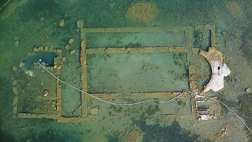
The İznik Basilica Underwater (Anadolu Ajansı)
The width of the central nave was deliberately maintained, making it decisive for the congregation’s positioning during worship. The broad central nave emphasizes the main axis extending from the entrance to the apse and forms the central area where the congregation gathered during rites. The side naves were likely used for more controlled movement, circulation, and secondary functions. The opus sectile floorings identified in the naves are interpreted as elements enhancing the visual impact of areas considered liturgically significant; these geometrically patterned floors elevate the symbolic representation of the space and provide a symbolic backdrop distinguishing the sacred area from mundane spaces.
The sequential arrangement of the nartex and the three-unit atrium in front of it on the western side of the structure indicates a graduated transition scheme liturgically. The atrium may have functioned as an area where the congregation gathered before entering the church, where ceremonial processions were organized on certain days, or where catechumens waited before baptism. The nartex, positioned as the final threshold before entering the main worship space, controlled the orderly entry of worshippers and served as an intermediate space for those partially participating in worship according to church discipline. Thus, the internal organization of this church along the lakeshore, progressing from west to east, reflects a gradual transition from the secular to the sacred.
The relationship between the interior space of the basilica and burial practices is also crucial for understanding its liturgical function. Tombs, particularly concentrated along the southern wall of the naos and extending up to the bema wall, demonstrate that the worship area also functioned as a necropolis. Tombs located close to the bema and apse suggest that the deceased held a status different from other congregants; such burials in the Byzantine world were typically reserved for clergy, local elites, or individuals associated with saint cults. The simultaneous use of the space for worship and burial reveals a practice that linked liturgical rituals with commemorative cults.
Written and oral traditions associating the structure with Saint Neophytos raise the possibility that the basilica functioned as a martyrion. In a church believed to have been built in memory of a saint martyred on the lakeshore, it would be expected that large congregations gathered along the shore during feast days dedicated to the saint, commemorative rituals were held at the saint’s tomb or relics, and icons and relics were carried in processions. The crosses and relic-carrying objects recovered during underwater excavations, even without direct inscriptions, imply that the space continued to serve as a significant worship center connected to the saint cult.
When evaluated together, these data reveal that the liturgical layout of the Lake İznik Basilica — defined by the sacred area of the apse and bema, the possible service and commemorative functions of the pastophoria chambers, the naves designated for the congregation, and the west-facing nartex–atrium sequence — outlines the internal organization of a sacred urban space on the lakeshore. The structure holds a critical position in the Christian-era religious topography of İznik, functioning simultaneously as a church for regular worship, an integrated burial ground, and a probable center of saint cult.
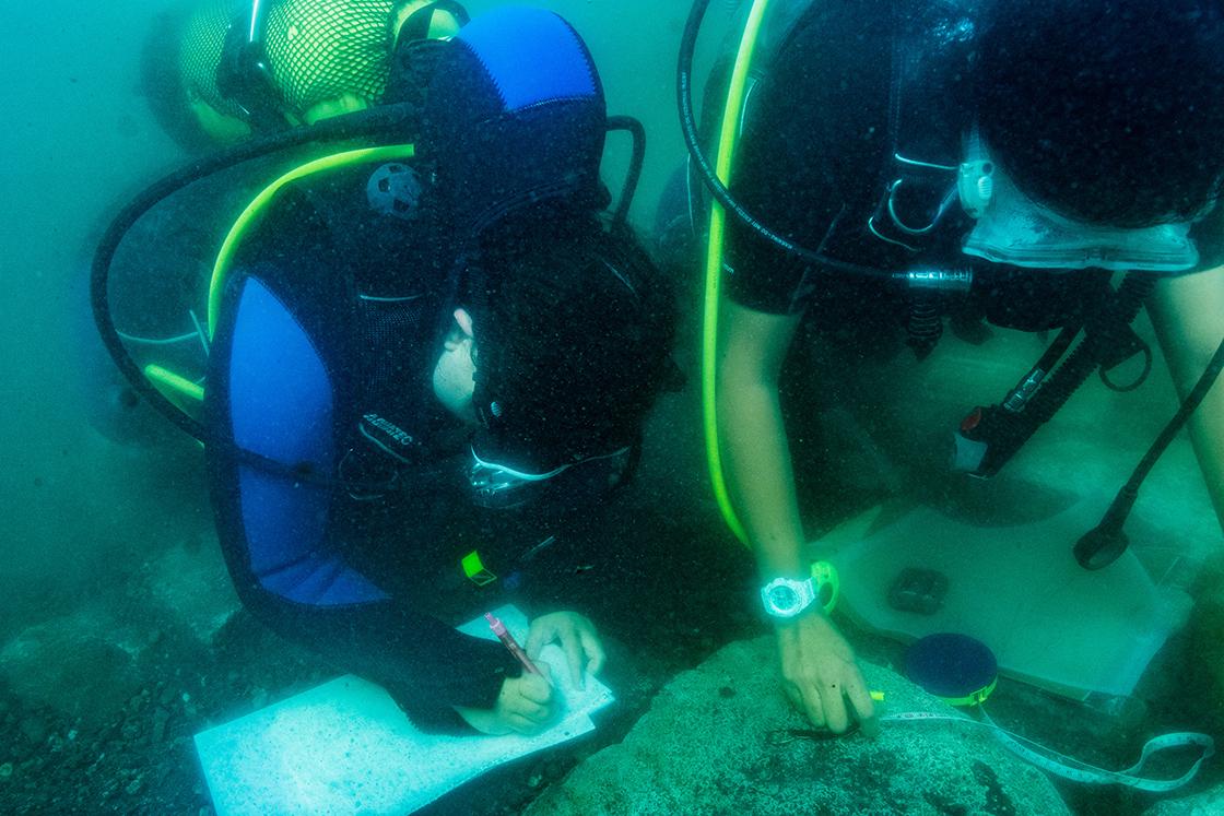
The İznik Basilica Remaining Underwater (Anadolu Ajansı)
Underwater excavations at the Lake İznik Basilica have revealed that the structure was not only used as a place of worship but also as a long-term burial ground. Particularly concentrated tombs within the naos, along the southern wall and near the bema, constitute a prominent example of the practice of intramural burial. A significant portion of these tombs date to later periods than the basilica’s initial use — specifically the Middle and Late Byzantine centuries — suggesting that the basilica transformed into a necropolis while continuing its liturgical function or after this function had weakened.
Tombs aligned side by side along the southern wall of the naos, constructed with brick tiles, form one of the most prominent areas of burial density. These rectangular tombs were lined with bricks on the sides, filled with earth inside, and covered with another layer of brick tiles. During excavation, these tombs were labeled with codes such as KM-01, KM-02, KM-03; in some cases, the remains of multiple individuals were found within a single tomb. This indicates that the tombs were reopened over time for family or group burials, demonstrating that the same location was repeatedly chosen for interment.
Some burials located very close to the bema wall are particularly significant in terms of hierarchy within the church. Proximity to the altar and apse in Byzantine burial tradition is typically associated with individuals of high status, such as clergy or local elites. The arrangement and positioning of tombs near the bema line in the Lake İznik Basilica suggest that those buried here held a different status within the congregation. Similarly, the sarcophagus identified within one of the pastophoria chambers stands out as a special burial example potentially associated with a saint or a venerated individual; such tombs imply that the space served not merely as a general burial area but as a focal point with strong memorial and sacred functions.
The tomb typology reveals the diversity of burial customs. Alongside brick-tiled tombs, stone sarcophagi, sarcophagus-type burials, and simpler secondary burials identified within fill layers have also been found. In some tombs, skeletons retain their anatomical articulations, indicating primary burials; in others, bones are clustered, suggesting secondary reorganizations following earlier burials. This pattern demonstrates that those interred within the church were not limited to a single period but belonged to a long-term burial tradition spanning multiple centuries.
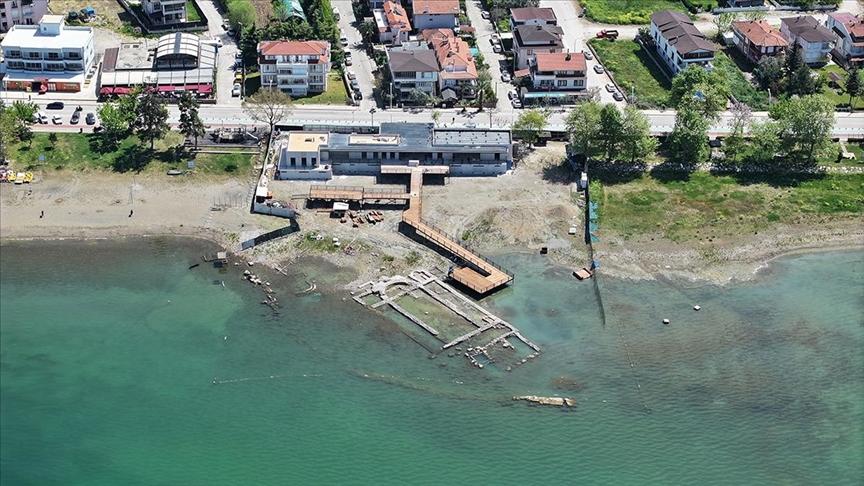
Drone View of the İznik Basilica (Anadolu Ajansı)
Anthropological examinations help interpret not only the spatial distribution of tombs but also the demographic characteristics of the deceased. The presence of child burials alongside adult burials in some tombs suggests that the church served a broad segment of the congregation, not merely a specific social group. Although details regarding gender and age distribution are limited due to the preservation state of the skeletons, the burial of individuals from different age groups within the same spatial unit strengthens the impression that the intramural cemetery was used on a familial or communal basis.
Artifacts recovered from the tombs provide additional information about burial rituals. In some burials, bronze or copper coins, small cross-shaped objects, simple jewelry pieces, and occasionally glass beads or pendants have been found. Coins help narrow the dating of burials and indicate the practice of placing money with the deceased as part of burial rites. Cross-shaped objects and relic-carrying crosses can be interpreted as elements clearly affirming the Christian identity of the burial. The rarity of rich or ornate grave goods suggests that the area functioned as a local congregational cemetery rather than a “prestige necropolis.”
The orientation of the burials is another notable feature. In many tombs within the church, heads were generally oriented west–east, with faces turned toward the east. This orientation reflects a widespread Byzantine practice associated with the belief in resurrection; the east, symbolically regarded as the direction of Christ’s return, imbued the practice of burying the deceased with their faces turned eastward with symbolic meaning.
The use of the basilica as a necropolis progressed alongside its abandonment. Irregular stone piles and disordered bone fragments found in upper sediment layers, alongside Late Medieval coins, indicate that the cemetery organization deteriorated over time, with some tombs being reopened or the burial area subjected to later interventions. Particularly, the nature of fill in the atrium and surrounding areas reveals that scattered burials or displaced skeletal fragments may also have been present in the vicinity of the structure; this suggests that the immediate surroundings of the church were also considered part of the burial area.
The small finds recovered from the Lake İznik Basilica demonstrate that the site possesses a multi-layered character not only architecturally but also in terms of daily life, worship practices, and long-term use. Ceramics, coins, glass and metal objects, and liturgically significant small artifacts contribute both to refining the chronology and to understanding the functions the site assumed during different phases.
Ceramic finds constitute the largest group among artifacts recovered during excavation and survey work. Ceramics from different trenches vary in production techniques, fabric properties, glazes, and decoration types, reflecting a broad chronological span from the Late Hellenistic period through the Middle and Late Byzantine centuries.
In early layers, particularly in the atrium and lower levels of the structure, fragments of tableware and storage vessels from the Late Hellenistic and Early Roman periods are prominent. These vessels, characterized by thick walls and often reddish or light brown fabrics, indicate that the lakeshore area was in active use before the basilica’s construction, supporting daily activities. This group includes vessels with glazed interiors, simple forms, as well as fragments with ribbed bodies and profiled rims.
In layers associated with the basilica’s construction and active use during Late Antiquity and Early Byzantine periods, higher-quality tableware, cooking vessels, and lamps become prominent. Thin-walled, well-fired, often red-glazed fragments with incised or relief decoration reflect the table culture of this era. Some examples feature interior glazing and simple geometric ornamentation. Alongside everyday vessels, fragments of oil lamps provide clues about the church’s lighting system; examples with cross motifs and simple symbols on the handle and disc sections can be directly linked to Christian iconography.
In upper layers associated with the Middle and Late Byzantine periods, the proportion of glazed ceramics increases. Glazed fragments in green, yellow, and brown tones, with fine glaze surfaces and combined incised-painted decoration techniques, represent the typical Byzantine ceramic repertoire of this era. These vessels are found mixed within tomb fills and surrounding sediment layers, serving as burial offerings, everyday utensils, or fill material.
Coins constitute the most important group of small finds for establishing the basilica’s chronology and distinguishing its phases of use. Coins recovered from various trenches provide a chronological sequence documenting both pre-basilica usage and the basilica’s operation during Late Antiquity and the Byzantine periods.
In lower levels, particularly in sondages within the atrium area, bronze coins dated to the 1st century BCE have been identified. These coins, associated with the administration of Bithynia–Pontus, indicate that the lakeshore area was an active zone even before and during the early Roman period. When evaluated alongside ceramic data, these finds support the interpretation that the shoreline was an integral part of urban activity prior to the basilica’s construction.
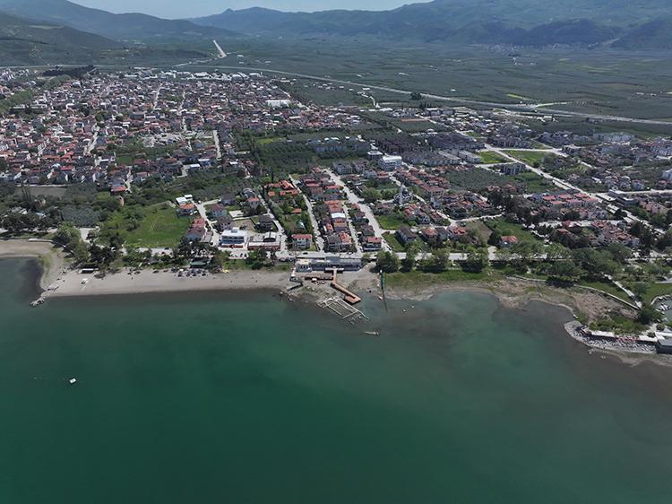
Distant View of the Basilica (Anadolu Ajansı)
In layers associated with the basilica’s construction and early use, coins dated to the late 4th and early 5th centuries are prominent. Bronze coins from the reign of Emperor Valens and his successors suggest that the church was functional during these centuries. Most of these coins were recovered within the naos and around the apse, sometimes in association with tombs; this indicates that burial activities were already present from the early phases of the church’s use.
In upper layers, particularly within tomb fill layers in the naos, Byzantine coins dated to the 10th–13th centuries are found. Some of these late-period coins were recovered in burial contexts, while others were found mixed within fill. The presence of coins placed with the dead in some burials indicates the continuation of classical Christian burial customs. At the same time, these late-date coins demonstrate that the basilica was used as a necropolis for a long time and remained visited well before its submersion under water.
Although glass finds are numerically more limited compared to ceramics and coins, they provide important insights into usage patterns. Glass fragments recovered from various trenches include pieces of drinking vessels, small bottles or bowls, and fragments of lighting elements. Some glass fragments exhibit thickened edges and junctions indicating the presence of hanging or footed lamps. The color of the glass is predominantly greenish or bluish, consistent with Early Byzantine production characteristics.
Metal finds exhibit a wider variety. Bronze and iron nails, various-sized fasteners, and structural components trace the remains of wooden superstructures and construction elements that have since dissolved in the lake environment. Particularly, a large concentration of nails and metal fragments recovered in trench 12A suggests that significant amounts of wood were used in the upper structure and that these wooden elements were preserved for a long time within the lakebed sediment.
Among metal objects of daily use are simple brooches, small rings and hooks, likely belonging to belts or clothing accessories. Some of these were found in burial contexts, while others were found mixed within fill. Metal jewelry items found in tombs indicate that the deceased were buried with their personal belongings; however, the rarity of elaborate, high-craftsmanship metal objects suggests a relatively modest material culture consistent with the overall character of the site.
Some small finds recovered from the Lake İznik Basilica can be directly linked to liturgical functions and the saint cult. Foremost among these are cross-shaped objects and relic-carrying fragments. One of the most striking finds is a bronze cross in the Latin cross form, featuring a hollow interior compartment and designed as a two-part object. Such crosses, with hollow bodies and lid-like closures, were commonly used in the Byzantine world to carry protective relics or small saintly fragments.
The discovery of such a relic cross within the church, in a location associated with a tomb or sacred area, supports the interpretation that the structure was connected to a saint cult. When considered alongside the traditional narrative associating the basilica with Saint Neophytos, this liturgical object suggests that the basilica was not merely a local congregational church but also a sacred site with martyrdom characteristics.
Among liturgical objects, smaller crosses, simple decorative crosses, and possible metal accessories used during worship are also present. Some of these were used directly in liturgy, while others were likely worn as jewelry or personal protective items. The presence of the cross motif on ceramic lamps and stone/plastic fragments further demonstrates that Christian symbolism was prominently reflected in the material culture of the structure.
Overall, the small finds vividly reflect the historical transformations experienced by the Lake İznik Basilica: Hellenistic–Roman vessels and coins document early shoreline use; Late Antique and Early Byzantine ceramics and coins reflect the basilica’s construction and worship phase; and Late Byzantine coins, glazed vessels, and tomb finds represent the period when the necropolis function became dominant.
The area where the Lake İznik Basilica is located represents a shoreline strip immediately outside the lake-facing section of the ancient city walls of Nicaea. The lakeside section of the city walls had a more tranquil topography compared to the land walls; this shoreline line became one of the city’s outward-facing faces, serving both defensive and transportation purposes. The basilica’s location approximately 50 metres from the shore suggests that, at the time of its construction, the structure was designed as a direct extension of the lakeshore; the current underwater condition is the result of later geomorphological processes.
Nicaea became one of the region’s most important cities from the Hellenistic period onward. During the Roman Empire, it developed administratively and economically, functioning as a regional center with its wall system, main streets, and public buildings. During this period, the lakeshore was likely equipped with small-scale piers, storage areas, and facilities related to water activities. The line where the basilica is located lies on an outer band parallel to the city’s lakeside wall; this band served as a transitional zone, both opening the city to the water and accommodating sacred structures and cemeteries beyond the walls.
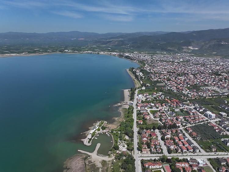
The Lakeshore Where the Basilica is Located (Anadolu Ajansı)
During Late Antiquity and the Byzantine periods, Nicaea’s urban fabric acquired a new religious topography with the rise of Christianity; churches, chapels, and martyrion structures became concentrated within and near the city walls. The basilica on the lakeshore became part of this new topography. The basilica’s orientation toward both the city and the lake suggests that it was situated at a point where land and probable water routes intersected, thus forming a sacred focal point connected not only to urban circulation but also to movement across the lake.
During the Ottoman period, İznik adopted an Islamic identity; new religious structures (mosques, prayer halls) became dominant in the urban fabric. In this period, early Christian structures along the lakeshore were largely erased from the surface; the Lake İznik Basilica continued to exist as a hidden cultural layer beneath the lakebed. Underwater excavations have made visible the archaeological traces of this long-term transformation process through architectural remains and sediment layers.
Nicaea became one of the most important cities in early Christian history at the imperial level. The councils held in the city and its episcopal organization elevated Nicaea beyond a local center to become a focal point in theological debates and church governance. In this context, churches and other Christian structures in İznik were not merely places of worship for local congregations but also areas through which decisions and movements accepted across the empire were disseminated.
The Lake İznik Basilica constitutes a unique example within this broader Christian topography due to its location on the lakeshore. The traditional narrative associating the structure with Saint Neophytos, who was martyred at a young age, has elevated the basilica from a city church to a sacred site with martyrdom characteristics. Considering the relationship between martyr cults and urban space during the Early Christian and Early Byzantine periods, the construction of such a structure on the lakeshore reflects a tangible connection between saint cults and urban space in Nicaea.
When evaluated alongside other churches and monasteries in the city, the exact status of the Lake İznik Basilica within the Nicaea episcopal organization remains undetermined; however, the basilica’s architectural scale, interior layout, and necropolis function suggest that it may have served not only a narrow congregation but a broader urban population. The intensity of intramural burials, long-term use, and liturgical objects suggest that this structure on the lakeshore may have become a focal point for both worship and commemorative practices in Christian-era İznik.
In terms of its plan schema and interior layout, the Lake İznik Basilica largely corresponds to the three-nave basilican church typology widespread in Anatolia and the Eastern Mediterranean during Late Antiquity and the Early Byzantine periods. The east-west oriented three-nave arrangement, the circular interior apse at the east, the side pastophoria chambers, and the nartex and atrium at the west constitute the fundamental elements of this common schema. The use of column rows, parapet slabs, and rich floor coverings for nave division reflects a hierarchical interior arrangement consistent with contemporary churches.
However, the fact that the basilica is directly located on the lakeshore and now lies underwater distinguishes it among regional examples. Although churches built along coasts or lakeshores in Anatolia are known, the existence of a well-preserved underwater basilica of this scale makes the Lake İznik Basilica a unique example in both underwater archaeology and the study of sacred structures related to shoreline topography. The basilica’s intact architectural form preserved on the lakebed has contributed underwater data to regional basilica typology studies.
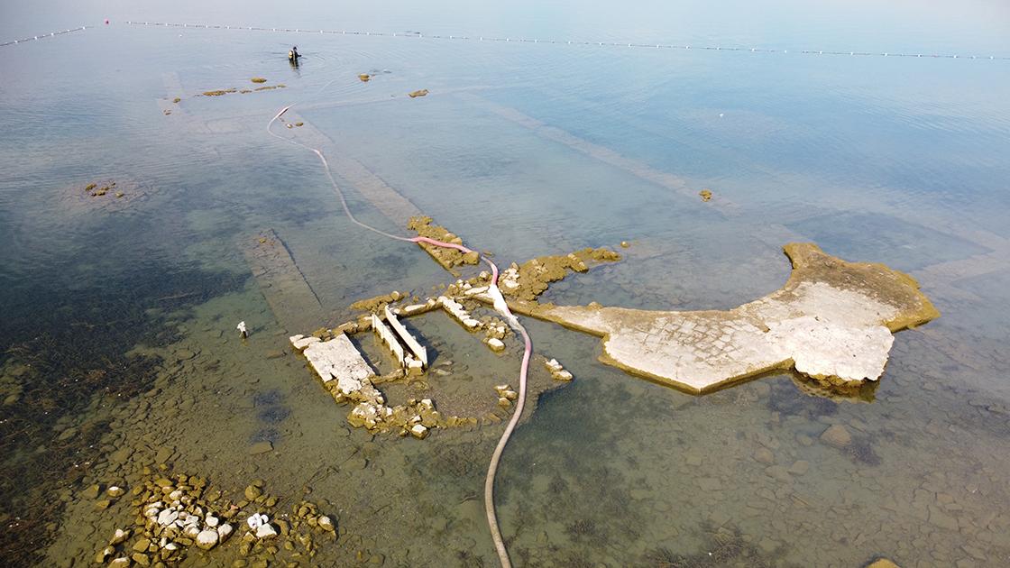
Basilica During Excavation Work (Anadolu Ajansı)
From a regional perspective, the Lake İznik Basilica must be evaluated in connection with other early Christian centers in Bithynia and its surroundings. The cities, episcopal networks, rural churches, and monastery complexes in the region formed a Christian geography through numerous structures built during similar periods. İznik occupied a central position within this network; the basilica on the lakeshore became one of the spatial manifestations of the city’s central position.
From an imperial perspective, the chronological and architectural data obtained from the Lake İznik Basilica illustrate how martyr cults, urban necropolises, and coastal settlements transformed between Late Antiquity and the Middle Byzantine period. In its early phase, the emphasis was on worship and martyrdom; in subsequent centuries, the necropolis function intensified; and in its final stage, it became a cultural layer preserved under lake waters due to geomorphological processes and earthquake effects. Thus, the Lake İznik Basilica serves both as a concrete example of Nicaea’s role in Christian history and as a research area where coastal and underwater archaeology are integrated; it has become an important data source for regional and imperial evaluations.
Work conducted at the Lake İznik Basilica has employed a specialized methodological framework adapted for underwater archaeology from the outset. Floating platforms anchored on the lake surface served both as the divers’ entry and exit point and as the operational area for measurements, recording, and artifact recovery. Thus, a controlled working environment was established, relatively independent of daily wave movements and shoreline traffic.
On the excavation site, diving operations were the primary method. Divers used air supply lines connected to surface snuba systems, eliminating the need for frequent surfacing to change tanks. In the lake environment, where visibility was sometimes limited, divers followed designated lines and reference points; excavation trenches were defined using a grid system tied to a coordinate framework. Each trench was recorded with elevation measurements and translated into plan and section drawings; underwater measurements were cross-checked using surface methods.
The sediment on the lakebed was systematically removed using centrifugal pumps connected to hose systems. Divers directed hoses to suction fine sediment and fill from designated trenches, transporting them to surface sieving units. Here, sieves with varying mesh sizes were used; clay, silt, and finest particles were returned to the water, while ceramics, glass, metal, and small bone fragments were retained on the sieves. Thus, systematic detection of small finds, which might otherwise be lost under low visibility conditions, became possible.
For documenting architectural remains, classical underwater measurement techniques were combined with photogrammetry and three-dimensional laser scanning. Wall traces, column bases, parapet slabs, sarcophagi, and nave floor coverings were photographed from multiple angles; these images were combined in software to generate three-dimensional models. Particularly, the opus sectile floors and delicate architectural elements were documented in three dimensions immediately after exposure during excavation, establishing a foundation for future reconstruction and virtual visualization studies.
During excavation seasons, a phased approach was applied to the exposure of human remains to prevent loss of anthropological and biological data. Bones were documented in situ without disturbance; after photographic and drawing records were made, they were carefully removed piece by piece. During this process, small supports and baskets were used to prevent bones from shifting or mixing, accounting for the buoyancy of water and sediment movement. Similar sensitivity was applied to wooden finds; visible wooden fragments were photographed and drawn after slight removal of surrounding fill, and those deemed necessary were removed in block form.
The conservation conditions of the Lake İznik Basilica are directly linked to the dynamics of the lake ecosystem. Fluctuations in lake level, changes in water temperature, and wave erosion along the shoreline are among the primary factors exerting long-term pressure on the architectural remains. Particularly, stone blocks and wall traces near the shore are more affected by sediment and sand movement caused by wind-driven surface waves.
Biological activity on the lakebed also constitutes a significant conservation concern. Algae, aquatic plants, and shellfish have adhered to both stone surfaces and wooden and metal finds. Over time, thick biological layers have made it difficult to read surface details and, in some cases, have accelerated the fragmentation of stone surfaces by creating micro-environments. Therefore, during excavation seasons, areas with dense biological deposits were identified; limited and controlled cleaning was performed
Audiovisual Sources
Ercengiz, A., A. S. Yumbul, Ş. Aktaş, and Mustafa Şahin. “2014 Yılının En Önemli 10 Keşfinden Biri: Aziz Neophytos Bazilikası.” 10. Ulusal Sualtı Hekimliği ve Hiperbarik Tıp Toplantısı. İstanbul, 2017. Accessed November 27, 2025.https://uludag.edu.tr/dosyalar/arkeoloji/mustafa/aziz_neophytos_bazilikasi.pdf
Köksal, Saliha Nur. "İznik Gölü'ndeki 1600 yıllık bazilika metaverse ortamında gezilebilecek." Anadolu Ajansı. Accessed November 27, 2025.https://www.aa.com.tr/tr/bilim-teknoloji/iznik-golundeki-1600-yillik-bazilika-metaverse-ortaminda-gezilebilecek/2960319.
Musei Vaticani. "Sistine Chaphel." Musei Vaticani. Accessed November 27, 2025.https://www.museivaticani.va/content/museivaticani/en/collezioni/musei/cappella-sistina/storia-cappella-sistina.html
Raddato, Carole. "Basilica of Saint Neophytos, probably built shortly after the Ecumenical Council of AD 325, but became submerged by the lake after an earthquake of AD 740, and was only rediscovered in 2014, Lake İznik, Turkey." *Flickr.* Accessed November 27, 2025.https://www.flickr.com/photos/carolemage/53467516937/in/photostream/
Research Works
Yılmaz, Büşra Nur. "İznik Gölü'ndeki bazilika, Papa 14. Leo'nun ziyareti için hazırlanıyor." Anadolu Ajansı. Accessed November 27, 2025.https://www.aa.com.tr/tr/kultur/iznik-golundeki-bazilika-papa-14-leonun-ziyareti-icin-hazirlaniyor/3721608.
Yılmaz, Büşra Nur. "İznik Gölü'ndeki bazilikanın 13. yüzyılda gömülerek terk edildiği ortaya çıktı." Anadolu Ajansı. Accessed November 27, 2025.https://www.aa.com.tr/tr/kultur-sanat/iznik-golundeki-bazilikanin-13-yuzyilda-gomulerek-terk-edildigi-ortaya-cikti/2380119.
Şahin, Mustafa, and A. Bilir. “Underwater Survey in Lake Iznik – 2015.” In North Meets East: Aktuelle Forschungen zu antiken Haefen III, 75–84. Hamburg, 2016. Accessed November 27, 2025.
Şahin, Mustafa, and M. R. Fairchild. “Nicea’s Underwater Basilica.” Biblical Archaeology Review 44, no. 6 (2018): 30–38. Accessed November 27, 2025.https://uludag.edu.tr/dosyalar/arkeoloji/mustafa/biblical_archaeology_iznik.pdf
Şahin, Mustafa, and S. Gündüz. “Underwater Excavation in Lake Iznik – 2015.” In North Meets East: Aktuelle Forschungen zu antiken Haefen III. Hamburg, 2016. Accessed November 27, 2025.https://uludag.edu.tr/dosyalar/arkeoloji/mustafa/2016_north_meets_east_iii.pdf
Şahin, Mustafa. “Bazilika Kilise’nin Scyphate Sikkeleri.” TINA Denizcilik Arkeoloji Dergisi 17 (2021): 44–59. Accessed November 27, 2025.https://uludag.edu.tr/dosyalar/arkeoloji/mustafa/scyphate_sikkeler.pdf
Şahin, Mustafa. “Birinci Ekümenik Konsil İznik Gölü’ndeki Bazilikada Mı Toplandı?” Bursa’da Zaman 18 (April 2016): 46–51. Accessed November 27, 2025.https://uludag.edu.tr/dosyalar/arkeoloji/mustafa/bursada_zaman_18.pdf
Şahin, Mustafa. “Neue Forschungen und Ausgrabungen in der Basilika des İznik Sees.” Asia Minor Studien 96 (Bonn, 2020): 93–106. Accessed November 27, 2025.https://uludag.edu.tr/dosyalar/arkeoloji/mustafa/nicaea_sahin.pdf
Şahin, Mustafa. “Sistine Salonu’nda Yer Alan Fresko Işığında Toplantı Mekanının Yeri.” In Bursa Atlası, edited by A. Sınar Uğurlu and S. Kırlı, pp. 2–28. Bursa, 2022. Accessed November 27, 2025.https://uludag.edu.tr/dosyalar/arkeoloji/mustafa/1_1_mustafa_sahin_3_28_syf.pdf
Şahin, Mustafa. “Underwater Excavation at the Basilica Church in İznik Lake – 2019.” International Journal of Environment and Geoinformatics 9, no. 2 (2022): 71–80. Accessed November 27, 2025.https://uludag.edu.tr/dosyalar/arkeoloji/mustafa/underwater_excavation_at_the_basilica_church_in_iznik_lake.pdf
Şahin, Mustafa. “İznik Gölü Bazilika Kalıntısı Sualtı Yüzey Araştırması – 2015.” TINA Denizcilik Arkeoloji Dergisi 4 (2015): 32–51. Accessed November 27, 2025.https://uludag.edu.tr/dosyalar/arkeoloji/mustafa/tina_4.pdf
Şahin, Mustafa. “İznik Gölü Bazilika Kalıntısında Sualtı Araştırmaları Başlıyor.” TINA Denizcilik Arkeoloji Dergisi 3 (2015): 69–70. Accessed November 27, 2025.https://uludag.edu.tr/dosyalar/arkeoloji/mustafa/tina_3.pdf
Şahin, Mustafa. “İznik Gölü Bazilika Kazıları – 2016.” TINA Denizcilik Arkeoloji Dergisi 6 (2016): 64–79. Accessed November 27, 2025.https://uludag.edu.tr/dosyalar/arkeoloji/mustafa/tina_6.pdf
Şahin, Mustafa. “İznik Gölü Bazilika Kazısı 2015.” In 38. Uluslararası Kazı, Araştırma ve Arkeometri Sempozyumu III, 23–27 Mayıs 2016, Edirne, 435–450. Ankara, 2017. Accessed November 27, 2025.
Şahin, Mustafa. “İznik Gölü Bazilika Sualtı Kazıları 2017–2018 Ön Rapor.” In 41. Kazı Sonuçları Toplantısı – 3, 443–462. Ankara, 2019. Accessed November 27, 2025.https://uludag.edu.tr/dosyalar/arkeoloji/mustafa/7358941kazi3pdf.pdf
Şahin, Mustafa. “İznik Gölü Bazilikal Kilisesi Sualtı Kazıları 2019–2020.” In 2019–2020 Yılı Kazı Çalışmaları, Volume 3, edited by A. Özme, pp. 341–350. Ankara, 2022. Accessed November 27, 2025.https://uludag.edu.tr/dosyalar/arkeoloji/mustafa/bazilika2020_2021.pdf
Şahin, Mustafa. “İznik Gölü Bazilikal Kilisesi Sualtı Kazıları 2021.” In 42. Uluslararası Kazı, Araştırma ve Arkeometri Sempozyumu, 23–27 Mayıs 2022, Denizli, 159–172. Ankara, 2023. Accessed November 27, 2025.https://uludag.edu.tr/dosyalar/arkeoloji/mustafa/bazilika_2021.pdf
Şahin, Mustafa. “İznik Gölü Bazilikası Sualtı Kazıları 2016–2019: Hipotezler ve Elde Edilen Veriler.” In Türkiye’de Sualtı Arkeolojisi, edited by H. Öniz, pp. 55–62. İstanbul, 2022. Accessed November 27, 2025.https://uludag.edu.tr/dosyalar/arkeoloji/mustafa/iznik_golu_bazilikasi_sualti_kazilari_2016_2019_hipotezler_ve_elde_edilen_veriler.pdf
Şahin, Mustafa. “İznik Gölü Sualtı Yüzey Araştırması ve Bazilika Kalıntısı Üzerine İlk Düşünceler.” In Türkiye’de Bizans Çalışmaları – Yeni Araştırmalar, Farklı Eğilimler, edited by K. Durak, N. Necipoğlu, and T. Uyar, pp. 19–30. İstanbul, 2022. Accessed November 27, 2025.https://uludag.edu.tr/dosyalar/arkeoloji/mustafa/bazilika_2022.pdf
Şahin, Mustafa. “İznik Gölü’ndeki Bazilika Kalıntısı İlk Olarak Ne Zaman Keşfedildi?” Bursa Günlüğü 9 (March–April–May 2020): 66–71. Accessed November 27, 2025.https://uludag.edu.tr/dosyalar/arkeoloji/mustafa/bursa1.pdf
Şan, Cem. "İznik, bazilika kalıntısının çevresinde yapılması planlanan ayine hazırlanıyor." Anadolu Ajansı. Accessed November 27, 2025.https://www.aa.com.tr/tr/kultur/iznik-bazilika-kalintisinin-cevresinde-yapilmasi-planlanan-ayine-hazirlaniyor/3545288.


Location | İznik District Bursa Province Selçuk Neighborhood | ||||||||
|---|---|---|---|---|---|---|---|---|---|
Distance from Shore | 50 m | ||||||||
Depth | 2-3 m | ||||||||
Main Findings | Glass vessel and lighting element fragments Coin groups Various tomb types Cross-shaped objects and bronze crosses with reliquary characteristics Ceramics Jewelry and clothing accessories Connecting elements Iron and bronze nails | ||||||||
Archaeologist Who Discovered the Area | Prof. Dr. Mustafa Şahin | ||||||||
Type | Site Area Three-aisled basilica | ||||||||
Functions | Saint Neophytos Martyrdom Site Necropolis area Early Christian period basilica | ||||||||
Width | Approximately 18.61 m | ||||||||
Historical Layers | Early and Middle Byzantine Late Antiquity Late Hellenistic – Early Roman Late Byzantine | ||||||||
North Aisle Width | Approximately 3.32 m | ||||||||
South Aisle Width | Approximately 3.15 m | ||||||||
Apse Diameter | Approximately 6.85 m | ||||||||
Length | Approximately 41.32 m | ||||||||
Central Aisle | Approximately 20.03 × 7.95 m | ||||||||
Location, Natural Environment, and Geomorphological Context
Discovery, Research, and Excavation History
Architectural Definition and Plan Schema
Construction Phases and Chronology
Pre-Basilica Usage
First Construction Phase: Late Antiquity
Repairs, Reorganizations, and Middle Byzantine Phases
Late Period Usage, Necropolis Function, and Abandonment
Liturgical Layout and Religious Function
Necropolis and Burial Practices
Small Finds and Material Culture
Ceramic Finds
Coin Finds
Glass and Metal Objects
Special Liturgical Objects
İznik City, Christian History, and Regional Context
Historical Development of İznik and Lakeshore Settlement
Christian History and İznik
Regional and Imperial Evaluation
Conservation, Management, and Underwater Archaeology Methods
Underwater Archaeology Methods
Conservation Issues and Risks