


This article was automatically translated from the original Turkish version.
+1 More
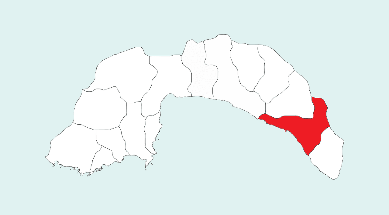
Alanya (District)
Foundation | In antiquity (Korakesion), district status: 1871 | ||||||||
|---|---|---|---|---|---|---|---|---|---|
Area | 1.598 km² | ||||||||
Notable Places | Alanya Castle Damlataş Cave Dim River Cleopatra Beach | ||||||||
Climate | Mediterranean climate | ||||||||
Population (2024) | 361.873 | ||||||||
Mayor | Osman Tarık Özçelik | ||||||||
District Governor | Fatih Ürkmezer | ||||||||
Historical and tourist center, Alanya is a coastal district of Antalya province. Located approximately 154 km from the city center of Antalya, it is built on a small peninsula along the Mediterranean coast and the surrounding plain. To the north lie the Taurus Mountains and to the south the Mediterranean Sea. The district center developed at the foot of a hill rising about 250 meters above sea level (Alanya Peninsula). The oldest known name of Alanya in antiquity was Korakesion; during the Byzantine period it was known as Kalonoros (beautiful mountain). In 1221, after its conquest by Seljuk Sultan I. Alâeddin Keykubad, the city was renamed Alâiye in honor of the new ruler. During the Republican era, the district’s name was officially changed to Alanya by a decision published in the Official Gazette in 1933, and this name gained official status following the visit of Atatürk in 1935. Today, with a population of approximately 360,000, Alanya is one of the most populous districts in Türkiye and an important tourism center.
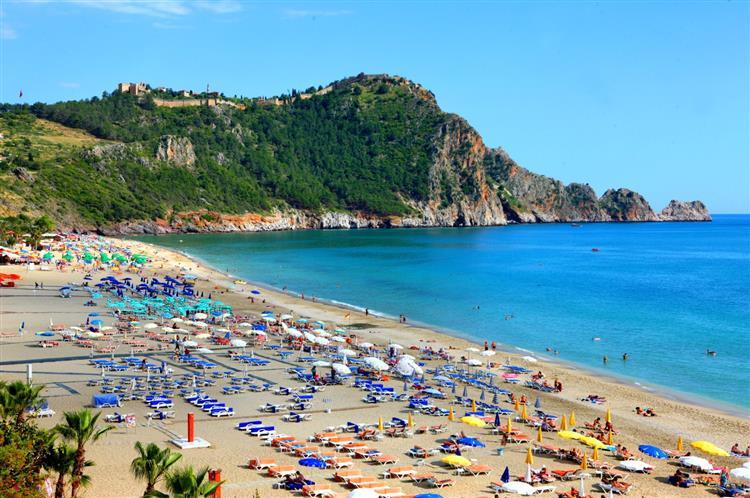
Damlataş Beach (Alanya Municipality)
Archaeological findings show that settlement in Alanya and its surroundings dates back to the Upper Paleolithic period. In antiquity, the region emerged as a port city between Pamphylia and Cilicia, known as Korakesion. In the 2nd century BC, Korakesion became a refuge for pirates but retained its importance after coming under Roman rule. At the beginning of the Middle Ages, the city remained under Byzantine administration and was known as Kalonoros, becoming a strategic point in Eastern Mediterranean trade. In 1221, Seljuk Sultan I. Alâeddin Keykubad besieged and captured Kalonoros Castle, incorporating the city into Seljuk territory. The Sultan renamed the city Alâiye after his title and commissioned the construction of a winter palace, a shipyard, and fortifications. During the Seljuk period, Alâiye became one of the region’s busiest ports; Sultan Keykubad and subsequent sultans frequently spent the winter months there, effectively using the city as a winter capital. Structures such as Alâiye Castle, its palace complex, Kızılkule, and the shipyard were built during this era.
With the decline of the Seljuk state at the end of the 13th century, the city briefly came under the control of the Kingdom of Cyprus, but the Karamanids soon established dominance in the region. In 1293, Karamanoğlu Mecdüddin Mahmud Bey captured the city and had the Friday sermon delivered in the name of the Mamluk Sultan. The famous traveler Ibn Battuta, who visited Alâiye in 1333, noted that its inhabitants were Turkmen and that administration was under Karamanoğlu Bey Yusuf. In 1366, a naval attack by King Pierre of Cyprus with a fleet of twenty-two ships was repelled by the resistance of the city’s population and the intervention of the Karamanoğlu bey.
During the Ottoman expansion in Anatolia, Alâiye surrendered to Ottoman forces commanded by Gedik Ahmed Paşa in 1471 and became part of the Ottoman administration. Initially a sanjak under the Karaman Eyalet, Alâiye was briefly attached to the Cyprus Beylerbeylik after the conquest of Cyprus in the 16th century but was later reintegrated into the Anatolian provincial system. In the early 19th century, Alâiye was a kazas under the Adana Eyalet; in 1868 it was attached to the Antalya (Teke) sanjak and acquired the status of a district of Antalya. In the early years of the Republic, the district appeared as a small coastal town, and its name was officially changed to Alanya in 1933. Mustafa Kemal Atatürk visited Alanya in 1935 and endorsed the new name.
Alanya district consists of a narrow coastal plain along the Mediterranean coast and the Taurus Mountain range immediately to the north. The district’s total area is approximately 1,600 km². It borders Gazipaşa to the east, Manavgat to the west, and Gündoğmuş district and Konya province to the north via extensions of the Taurus Mountains. The Alanya Plain was formed by alluvial deposits from rivers such as Oba Çayı and Dim Çayı. The Alanya Peninsula, extending into the Mediterranean and encircled by walls approximately 6.5 km in length, is the district’s iconic landmark. The city center is located at the foot of this peninsula and on the plain to its west. Alanya is connected to Antalya by road, approximately 154 km away. Additionally, air travel is possible via Gazipaşa Alanya Airport, located 45 km from the district center.
The Mediterranean climate dominates the district; winters are mild and rainy, while summers are long, hot, and dry. The average annual temperature is around 20°C and annual rainfall is approximately 1,000 mm. Frost is rare even along the coast during winter. Summer months extend over roughly eight months, during which sea water temperatures average above 25°C.
As of 2024, the population of Alanya district is 361,873. Males constitute 50.7% and females 49.3% of the population. Population growth accelerated notably from the second half of the 20th century. The district’s population, which was approximately 3,000 in 1880, declined to 4,727 by 1927 but surpassed 10,000 again by 1960 and reached 28,773 by 1985. In the following decade, Alanya experienced intense migration and grew rapidly; today, with a population exceeding 360,000, it is the most populous district in Antalya. According to TÜİK data, residents from all 81 provinces of Türkiye live in Alanya. Approximately 43% of the district’s population is registered in Antalya’s population records, while the remainder are registered in other provinces. Alanya is also a district with a significant foreign resident population. According to 2024 TÜİK data, 36,465 foreign nationals reside in the district. The largest foreign communities are from Russia, Ukraine, Germany, and Kazakhstan. The high proportion of foreign residents has led to the formation of a multilingual and multicultural social structure.
Alanya’s economy is primarily based on tourism, agriculture, and construction. Thanks to its mild climate and fertile plains, agricultural production in the region is diverse; traditionally, citrus fruits, cotton, and especially banana cultivation hold significant importance. Alanya, the leading producer of bananas in Türkiye, also grows avocado, a tropical fruit. In recent years, greenhouse farming has become widespread, with banana greenhouses and protected vegetable cultivation employing modern agricultural techniques. The industrial sector is limited and mainly focused on processing agricultural products and producing construction materials. The service sector dominates the district’s economy. Tourism, in particular, has grown rapidly since the 1980s and now provides the majority of employment. Hundreds of hotels, restaurants, and tourism facilities operate in the district, and the population doubles during the summer season. The construction and real estate sectors are also active due to their connection with tourism.
Alanya is one of Türkiye’s leading tourism destinations due to its natural beauty and historical heritage. Its iconic landmarks include Alanya Castle, Kızılkule, and the Seljuk Shipyard. In terms of natural attractions, Alanya is renowned for its long beaches and caves. Kleopatra Beach, Damlataş Cave, Dim Cave, and Sapadere Canyon are among the district’s foremost attractions.
Cultural events such as the annual Alanya International Tourism and Art Festival and Jazz Days add value to the district. Alanya cuisine features local dishes such as nohutlu hibeş, ülübü yemeği, ilibada sarması, and laba dolması, as well as unique sweets made with bananas and citrus marmalades. The district’s multicultural structure is also reflected in its cuisine, offering international variety.
Alanya Belediyesi. “İlçemiz Hakkında.” Accessed April 19, 2025.https://www.alanya.bel.tr
Alanya Kaymakamlığı. "Alanya’nın Tarihi." Accessed April 19, 2025.https://www.alanya.gov.tr
Ministry of Culture and Tourism. "Culture Portal: Alanya." Accessed April 19, 2025.https://www.kulturportali.gov.tr
Türkiye Diyanet Vakfı İslam Ansiklopedisi. "Alanya." Accessed April 19, 2025.https://islamansiklopedisi.org.tr/alanya
Türkiye İstatistik Institute (TÜİK). "Adrese Dayalı Nüfus Kayıt Sistemi (ADNKS) 2024." Accessed April 19, 2025.https://data.tuik.gov.tr
Alanya (District)
Foundation | In antiquity (Korakesion), district status: 1871 | ||||||||
|---|---|---|---|---|---|---|---|---|---|
Area | 1.598 km² | ||||||||
Notable Places | Alanya Castle Damlataş Cave Dim River Cleopatra Beach | ||||||||
Climate | Mediterranean climate | ||||||||
Population (2024) | 361.873 | ||||||||
Mayor | Osman Tarık Özçelik | ||||||||
District Governor | Fatih Ürkmezer | ||||||||
History
Geography and Climate
Population and Demographics
Economy
Tourism, Culture and Cuisine