`lightning` Related Article Results
Difference Between Lightning and Thunder
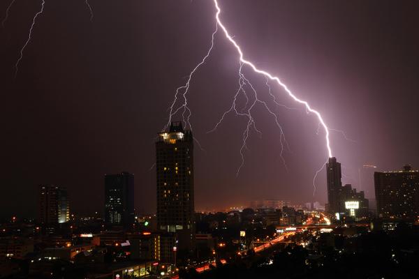
First, it is important to understand that both phenomena are the result of the same fundamental process. The primary cause is electrical discharge in the atmosphere. Intense air movements within storm clouds (cumulonimbus) cause ice crystals and water droplets to rub against each other, accumulating enormous amounts of electric charge. The upper parts of the cloud typically become positively charged (+), while the lower parts become negatively charged (–). This imbalance seeks to neutralize itse
EN
Harun Olçay

Why Do Lightning Bolts Form Different Shapes in the Sky?
Lightning takes on different forms in the sky depending on its point of origin and the direction of electric charge movement. Lightning between clouds and the ground is typically vertical, while intracloud and intercloud lightning spreads horizontally or in a network-like pattern. This variation arises from the distribution of electric charges within and around the clouds.Lightning is a highly orderly process resulting from the restoration of electrical balance in the atmosphere. These phenomena
EN
Mehmet Bağcı

What is Oraj?
Oraj is a weather phenomenon meaning thunderstorm. It refers to situations in which lightning suddenly flashes in the sky, a loud thunderclap is heard, and heavy rain begins. Oraj occurs when electrical charges accumulated within clouds are suddenly discharged.How Does Oraj Form?For an oraj to form, certain specific conditions must be present in the atmosphere. When the Earth’s surface heats up, the moist air above it also warms and begins to rise. This rising moist air encounters the colder lay
EN
Kasım Emre Anıl
 Li
LiLightning Flashes
Lightning flashes occur due to the sudden and powerful discharge of a large electrical potential difference between a cloud or between a cloud and the ground. Lightning is typically observed within or around cumulonimbus clouds, which are storm clouds. During the discharge, the temperature of the air rises above 30,000 °C, transitioning into a plasma state and producing a brilliant flash of light along with a powerful sound burst (thunder).Physical and Electrical Properties of Lightning FlashesT
EN
Ahmet Burak Taner

TUSAŞ Şimşek
The ŞİMŞEK High-Speed Target Aircraft System is a project initiated in 2009 by Turkish Aerospace Industries Inc. (TUSAŞ) to meet the training requirements of Türkiye’s air defense units. The system is designed to simulate the flight characteristics of hostile aircraft and guided munitions for use in surface-to-air and air-to-air missile training exercises.Developed using TUSAŞ’s own resources and supported by TEYDEB, the project builds on the experience gained from the Turna Target UAV System pr
EN
Mete Düztürk

Clouds
When you look up at the sky, you see clouds drifting like pure white cotton. But are these clouds actually cotton? No! Clouds are special atmospheric phenomena composed of water droplets and ice crystals.🔍 How Do Clouds Form?It all begins with air! As air warms, it rises upward. This air carries water vapor. As it rises, the air cools, causing the water vapor to condense into tiny droplets and form clouds. This process is called condensation.But water vapor alone is not enough. There must be ti
EN
Elif Laçin

TUSAŞ Super Lightning
Süper Şimşek is a modular unmanned aerial vehicle (UAV) system developed indigenously by Turkish Aerospace Industries (TUSAŞ), capable of performing missions at high subsonic speeds. Initially designed as a "target aircraft" for training and testing air defense systems, the platform has evolved into a multirole operational system through the integration of capabilities in munition carriage, electronic warfare, and swarm technology.Technical Specifications and Performance ParametersSüper Şimşek i
ENMete Düztürk