


This article was automatically translated from the original Turkish version.
+1 More
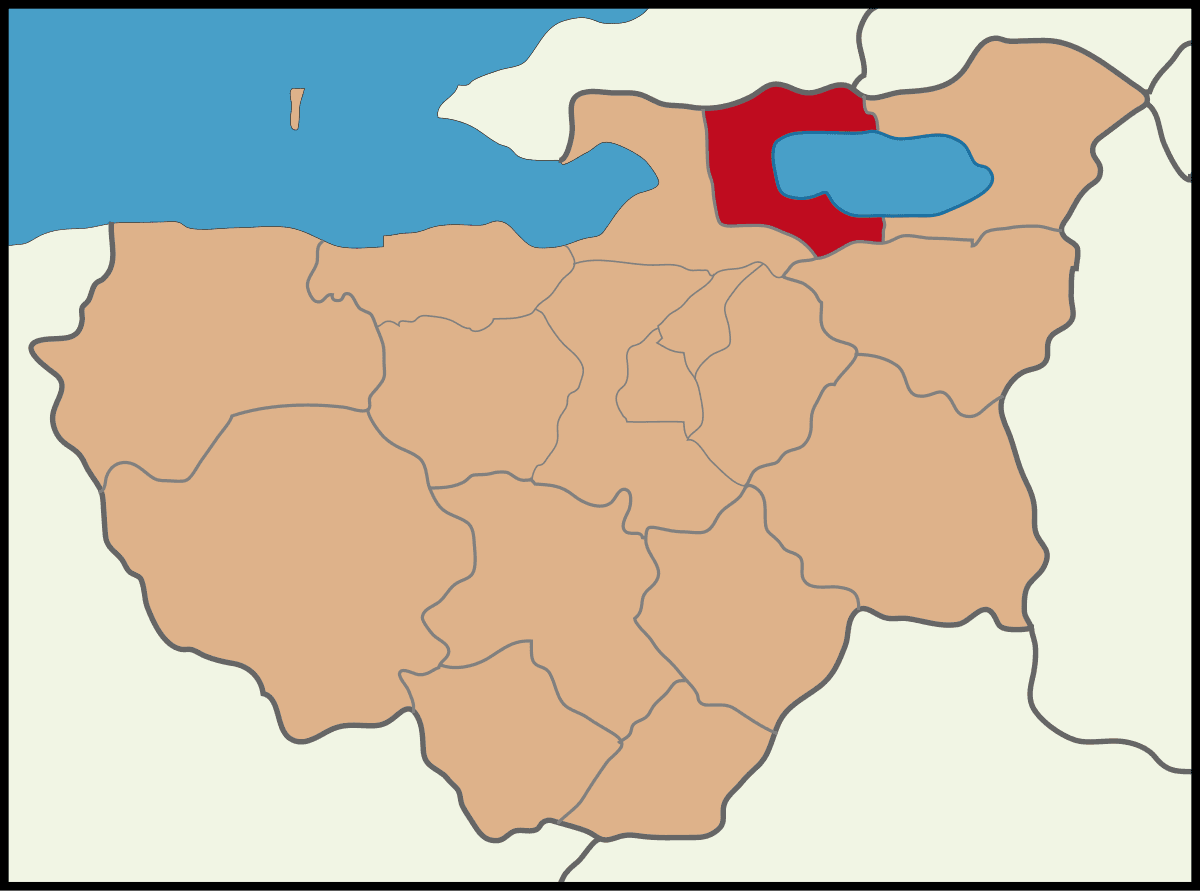
Orhangazi
Province | Bursa | ||||||||
|---|---|---|---|---|---|---|---|---|---|
Area | 476 km² | ||||||||
Elevation | 125 metres | ||||||||
Population (2024) | 82.111 (TÜİK 2024 ADNKS) | ||||||||
Climate | Mediterranean/Continental Transitional Climate | ||||||||
Neighboring Districts | Yenişehir Gemlik İznik | ||||||||
Cultural Activities | Orhangazi Olive Festival | ||||||||
Mayor | Bekir Aydın (as of 2024) | ||||||||
District Governor | Zafer Karamehmetoğu (as of 2024) | ||||||||
Orhangazi is a district of Bursa, located west of the İznik Gölü in the southern part of the Sea of Marmara. Formerly known as Pazarköy, Orhangazi is situated on a fertile plain along the shores of the İznik Gölü. To its north lies the province of Yalova, to its west Gemlik, to its south Yenişehir, and to its east the district of İznik. The district, surrounded by the Samanlı Mountains to the north and the Katırlı Mountains to the south, has a basin-like shape. Located 45 kilometers from the city center of Bursa, the area is approximately a 40-minute drive from Bursa.
The district is one of the key junctions along the Bursa-Istanbul Road. Winters are cool and summers mild, characteristic of its climate. Orhangazi stands out due to its strategic location between the İznik Gölü and the Gemlik Gulf in northeastern Bursa, its branded agricultural production centered on Gemlik olives, its rich history dating back to Orhan Gazi, the second Ottoman sultan, and its growing industrial infrastructure. With a population exceeding 80,000, it is a dynamic district.
Orhangazi is one of the oldest settlement sites in Anatolia. Excavations at the Ilıpınar Höyüğü in the Topselvi neighborhood of Orhangazi have revealed that the first human settlement in the district dates back 8,000 years.
The earliest known inhabitants of Orhangazi were the Bitinians; the region came under Roman administration in 74 BC. The settlement, later known as Basilinapolis, became part of the Byzantine Empire in 395.
Between 1085 and 1097, the region came under the control of the Anatolian Seljuk State. In 1097, the town and its surroundings were plundered by Crusaders. From 1024 to 1261, it fell under the rule of the Byzantine Empire of Nicaea.
In 1332, the region was conquered by Orhan Bey and incorporated into Ottoman territory. Orhan Bey built a mosque and a bathhouse in his name and settled local Turkish tribes in the area. This settlement, then called Pazarköy, was administratively subordinate to İznik at the time.
In 1879, Pazarköy became a subdistrict center. In 1893, it was elevated to the status of a district center under Bursa Province and adopted the name Orhangazi in 1913.
During the War of Independence, the district suffered under Greek occupation and experienced its darkest and most unfortunate period. The occupation lasted from 1920 to 1922. On September 10, 1922, Greek forces withdrew from the district. Having burned and destroyed much of the area, the district center was relocated for two years to the village of Gürle.
Orhangazi, which remained a small settlement for a long time after its founding, experienced rapid development following the increasing importance of the Bursa-Yalova highway and later with the opening of the Istanbul-İzmir motorway and the Osmangazi Bridge.
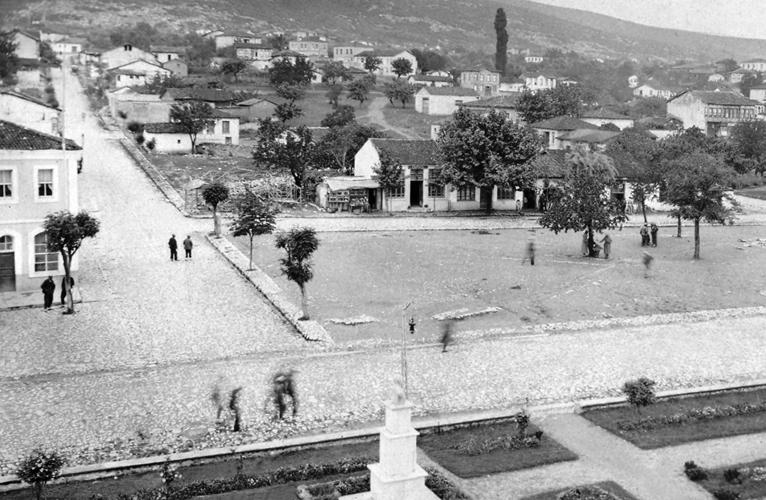
Bir Zamanlar Orhangazi (Orhangazi Belediyesi)
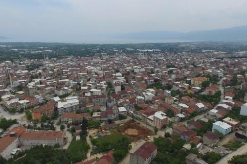
Orhangazi Kuş Bakışı Görünümü (Orhangazi Belediyesi)
The İznik Gölü is the foremost natural attraction within Orhangazi’s boundaries. As Turkey’s fifth largest lake, it stands out for its tranquil atmosphere and lush green surroundings. Water sports such as sailing, rowing, and canoeing are practiced along its shores, especially favored by nature enthusiasts and campers on weekends. Watching the sunset along the lake’s edge during summer months offers an unforgettable experience for both locals and tourists. Additionally, amateur fishing events held on the lake provide an alternative for those seeking to spend time immersed in nature.
Keramet Thermal Springs, located approximately 10 kilometers from the district center, make a significant contribution to regional health tourism through their natural thermal sources. The spring water maintains a constant temperature of around 30 °C throughout the year and is traditionally believed to benefit various ailments, from skin conditions to rheumatism. In addition to bathing in the limestone natural pools, the surrounding green areas are ideal for picnics and day trips. Keramet attracts both domestic and regional tourists, even during winter months, thanks to its warm waters.
Trekking and mountain sports are practiced on the Katırlı and Samanlı Mountains. Additionally, Gürle Mountain is highly suitable for paragliding, and festivals and competitions are regularly organized there.
In Orhangazi’s social life, the Orhangazi Olive Festival, held annually in November, is one of the most important cultural events. Since its inception in 1978, the festival has been continuously organized and serves as a major platform reflecting the district’s olive-growing tradition and agricultural identity. During the festival, events such as the “Olive Beauty” contest, olive oil-based cuisine competitions, local product exhibitions, folk dance performances, and concerts take place. Additionally, the “Olive-Themed Photography Competition,” open to amateur and professional photographers, aims to establish an aesthetic connection between art and nature. The festival is not merely an agricultural celebration but also a reflection of Orhangazi’s historical and cultural identity.
Orhangazi’s cuisine features a natural and healthy dietary culture centered on olive oil, thanks to the high volume of Gemlik-type olive production. Classic Aegean-Mediterranean dishes such as olive oil-stewed artichokes, stuffed grape leaves, and stuffed zucchini flowers are commonly found on Orhangazi tables. In addition, freshwater fish from the İznik Gölü, such as carp and tench, are served grilled or steamed, adding distinctive flavors to local meals.
Orhangazi Belediyesi. "Fotoğraf Galerileri." Accessed April 24, 2025.https://orhangazi.bel.tr/fotograflar.
Orhangazi Belediyesi. "Orhangazi Tarihi." Accessed April 24, 2025.https://orhangazi.bel.tr/sayfa/orhangazi-tarihi.
Orhangazi Belediyesi. "İklim." Accessed April 24, 2025.https://orhangazi.bel.tr/sayfa/iklim.
Turkiye Statistical Institute (TÜİK). "Adrese Dayalı Nüfus Kayıt Sistemi (ADNKS) Sonuçları, 2024." Accessed April 24, 2025.https://data.tuik.gov.tr/Bulten/DownloadIstatistikselTablo?p=mrUHYGTWyI7m1gItx3gEMDRQQ0yKBoK%2FY4%2F7PGKKmePr6h55u6PVE825fke17fBi.

Orhangazi
Province | Bursa | ||||||||
|---|---|---|---|---|---|---|---|---|---|
Area | 476 km² | ||||||||
Elevation | 125 metres | ||||||||
Population (2024) | 82.111 (TÜİK 2024 ADNKS) | ||||||||
Climate | Mediterranean/Continental Transitional Climate | ||||||||
Neighboring Districts | Yenişehir Gemlik İznik | ||||||||
Cultural Activities | Orhangazi Olive Festival | ||||||||
Mayor | Bekir Aydın (as of 2024) | ||||||||
District Governor | Zafer Karamehmetoğu (as of 2024) | ||||||||
No Discussion Added Yet
Start discussion for "Orhangazi (District)" article
History
Geography and Climate
Nature and Health
Festivals and Cultural Events
Local Cuisine