


This article was automatically translated from the original Turkish version.
+1 More
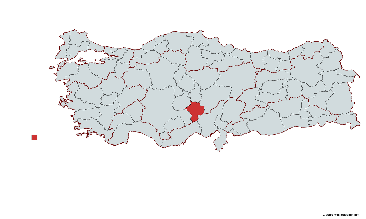
Niğde
Country | Türkiye | ||||||||
|---|---|---|---|---|---|---|---|---|---|
Region | Central Anatolia Mediterranean Regions | ||||||||
Population (Number) | 372.708 | ||||||||
Districts | Altunhisar, Bor, Çamardı, Çiftlik, Ulukışla | ||||||||
Governor | Cahit Çelik | ||||||||
Mayor | Emrah Özdemir | ||||||||
Area Code(s) | 388 | ||||||||
License Plate Code | 50 | ||||||||
Surface Area | 731.200 km2 | ||||||||
Niğde Province is located in the southeastern part of Türkiye's Anatolia Region. The city, at an elevation of 1,229 meters, is one of the region's significant settlement centers with a population of 372,708 according to 2023 data.
The history of Niğde extends back to the Hittite period. The region known as "Nahita" has settlement traces dating as far back as 5000 BCE. In addition to the Hittites, the Assyrians, Phrygians, and Medes ruled the area. During the Persian period (546 BCE), the region came under satrapal administration and was incorporated into the Hellenistic Cappadocia Kingdom following Alexander the Great’s conquest of Anatolia. In 17 BCE, the region was annexed by the Roman Empire.
When the Roman Empire split in 395, Niğde remained within Byzantine territory. During this period, the city of Tyana (Kemerhisar) became a major center. From the 7th century onward, the region suffered Arab raids, and Tyana was largely destroyed in 931. One of the important remains from the Byzantine era is the Gümüşler Monastery.
Following the Battle of Manzikert in 1071, Niğde came under Seljuk rule. During the reign of II. Kılıç Arslan, the city became an important center and was adorned with structures such as the Alaaddin Mosque (1223) and Hüdavent Hatun Tomb (1312). After the Battle of Köse Dağ in 1243, Niğde fell under Mongol invasion and came under Ilkhanid administration. In 1357, the Karamanids assumed control.
Niğde was incorporated into Ottoman territory during the reign of Yıldırım Bayezid, but after the Battle of Ankara in 1402, it reverted to Karamanid control. Ultimately, in 1471, it was definitively brought under Ottoman rule by Fatih Sultan Mehmet. During the Ottoman period, it remained as a district center within the Karaman Eyalet. According to 16th-century tax registers, the city had 29 mahalles and a population of approximately 4,000 to 5,000. In the 19th century, Niğde developed through its orchards and gardens, with trade and craftsmanship coming to the fore.
With the proclamation of the Republic, Niğde attained provincial status in 1923. The city gained significant commercial and social momentum after the railway opened in 1933. During the 1960s, it continued to grow through the construction of official buildings, expansion of educational institutions, and industrial investments. Niğde University, established in 1992 (now Ömer Halisdemir University), has made a major contribution to the province’s development.
Niğde lies between 37°10' and 38°58' north latitudes and 33°10' and 35°25' east longitudes. It borders the provinces of Aksaray, Nevşehir, Mersin, Adana, Kayseri, and Konya. Geographically, it forms the southern boundary of the Mediterranean Region with the Bolkar Mountains and Aladağlar. The districts of Çamardı and Ulukışla lie within the Mediterranean Region.
The northern and eastern parts of the province have a rugged structure, while the central, southern, and western areas exhibit a flatter topography. The Niğde Massif in the north averages 2,000 meters in elevation and features peaks reaching up to 2,700 meters. Demirkazık Peak (3,734 m) is the highest point in the region. The Aladağlar, located in the east and reaching 3,734 meters in height, are bounded by the Ecemiş Fault and feature steep cliffs. The central and western areas, covered with volcanic rocks, lie at elevations of 1,000 to 1,200 meters, with this elevation increasing toward the south, reaching 1,500 meters near Başmakçı Village. Important elevations include Hurç Mountain (2,887 m), Karabel Hill (2,014 m), and Koyak Hill (2,396 m). The northern and eastern parts have a rugged structure, while the southern and western parts have a flatter topography. Demirkazık Peak (3,734 m) is one of the highest points in the region.
Due to low rainfall, steppe and steppe vegetation are widespread throughout the province. Forested areas are limited and occur mainly on the higher slopes of the Taurus Mountains, Hasan Mountain, and Melendiz Mountains. In lowland areas, steppe plants, shrubs, and drought-resistant grasses are common.
Niğde has a continental climate with hot, dry summers and cold, snowy winters. The annual average temperature is 10°C, with the highest recorded temperature at 37.7°C (July) and the lowest at -21°C (January).
The prevailing winds in the province are the Poyraz from the north, the Lodos from the southwest, and the Kıble from the east. In particular, the Poyraz wind lowers temperatures during the winter months, while the Lodos wind raises temperatures during the spring months.
The annual average precipitation in Niğde is 0.9 mm, with the highest rainfall occurring in April (78.5 mm) and the lowest in July (0.2 mm). Precipitation during winter months generally falls as snow, while in spring it occurs as rain.
In 19th-century censuses, approximately 10,385 people lived in the city, and this number increased during the Ottoman period. After the proclamation of the Republic, population growth continued, with railway construction and industrial investments contributing to this increase.
According to 2024 data, Niğde’s total population is 372,708. The female population is 186,509 and the male population is 186,199.
Niğde’s economy is based on agriculture, animal husbandry, and industry. The Niğde Central Organized Industrial Zone, the Bor Leather Organized Industrial Zone, and the Birko Koyunlu A.Ş. carpet factory form the foundation of the city’s industrial infrastructure.
Apple trees are the most numerous in Türkiye in Niğde, which also contributes approximately 25% of the country’s potato production. Additionally, the Bor Leather Organized Industrial Zone and the Niğde Central Organized Industrial Zone are among the province’s key industrial centers. The Birko Koyunlu A.Ş. carpet factory and traditional handicrafts hold an important place in the city’s commercial life. Particularly, Niğde carpets have found buyers in international markets.
Niğde, besides being an important center in agriculture, animal husbandry, and industry, also attracts attention through its tourism potential and historical richness. With educational and infrastructure developments since the Republican era, the city continues to be one of the key points of regional development. Located within the Cappadocia region, Niğde draws attention through its archaeological sites and natural beauty. It has also achieved significant progress since the Republican period in education, culture, and public works. With major transformations in its population and economic structure, the city will continue to be one of the important centers of regional development in the future.
Niğde has local anonymous folk songs.
Anonymous folk song titled “Niğde Bağları.” Performed by İlhan SANCAKTAROĞLU. Rhythm, Saz, and Vocals: Recep ADIYAMAN. Mix Mastering: Çağdaş ÖZMEN. https://nigde.ktb.gov.tr/TR-291405/nigde-turkuleri.html
The main legends associated with the Niğde region are as follows:
Niğde is a city noted for its historical and natural beauty. Its location within the Cappadocia Region enhances its tourism appeal. Historical sites such as the Gümüşler Monastery and the Ancient City of Tyana significantly increase the region’s visitor potential. Thermal springs, mountain and winter tourism opportunities, rich historical fabric, and archaeological sites are among the elements that make Niğde a potential tourism center. The city’s main rivers include Ecemiş River and Uluırmak.
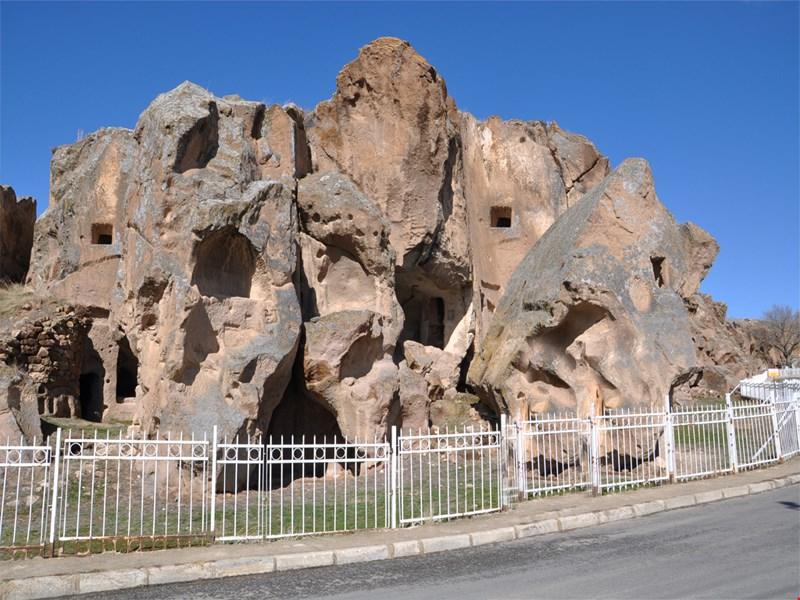
Gümüşler Monastery (http://www.nigde.gov.tr/gumusler)
Niğde’s tourist and cultural sites include:
These tourist and cultural sites reflect Niğde’s historical richness and natural beauty.
Niğde, with an area of 731,200 km2 , has five districts, 29 municipalities, 23 towns, and 131 villages. The current mayor is Emrah Özdemir.
Niğde has five districts:
The current governor is Cahit Çelik. The governors of Niğde in chronological order are as follows:
Asım Bey 23.10.1924 - 09.03.1925
Salih Cemal GÜLEN 19.03.1925-06.11.1925
Hüsnü Bey 14.11.1926-20.09.1931
Sakıp BEYGO 20.09.1931-27.05.1933
Ziya Bey 27.05.1933-20.11.1936
Faik ÜSTÜN 22.11.1936-11.07.1939
İsmail Sefa APAYDIN 29.07.1939-25.05.1942
Fevzi GÜREL 08.06.1942-19.06.1942
Hamit ONAT 01.07.1942-23.03.1943
Raşit DEMİRTAŞ 04.05.1943-10.06.1944
Ahmet Niyazi MERGEN 24.12.1944-06.02.1947
Yahya Ömer ERYETKİN 30.02.1947 -28.07.1949
Tevfik KUTLAR 29.07.1949-16.06.1950
Saadettin ERTÜRK 28.07.1950-17.05.1951
Hasip KOYLAN 18.05.1951-16.02.1953
Taki GÜRKÖK 08.06.1953-15.06.1956
Sedat TULGA 16.06.1956-25.09.1956
Hilmi İNANÇ 29.09.1956-19.05.1958
Hayrettin NAKİPOĞLU 31.07.1958-03.02.1959
Mahmut Nedim EVLİYA 20.02.1959-27.05.1960
Ahmet ÖCAL 27.05.1960-13.06.1960
Niyazi TOKER 13.06.1960-25.10.1960
Dündar EGEL 27.10.1960-13.05.1961
Vefik KİTAPÇIGİL 17.06.1961-05.07.1963
İbrahim ÖZTÜRK 05.07.1963-27.01.1966
Enver KAZANOĞLU 28.01.1966-18.09.1970
Hüseyin ÖĞÜTCEN 18.09.1970-28.06.1971
Selami CELAYİR 30.06.1971-19.07.1975
Zekeriya ÇELİKBİLEKLİ 21.07.1975-13.02.1978
E. Berki KOÇOĞLU 15.02.1978-06.12.1979
Behçet GÜLER 10.12.1979-10.09.1980
İlhan SÖZGEN 12.09.1980-25.10.1980
Bedri NAZLIOĞLU 26.10.1980-06.09.1982
Ünal ÖZGÖDEK 20.09.1982-29.02.1988
Ahmet ÖZYURT 29.02.1988-14.08.1991
Tuncer PERÇİNLER 19.08.1991-21.02.1992
Muammer GÜLER 27.02.1992-27.09.1993
Zeki ŞANAL 27.09.1993-24.06.1994
Mevlüt ÇETİNKAYA 01.07.1994-15.04.1996
Adil YAZAR 17.04.1996-04.10.1999
Refik Arslan ÖZTÜRK 05.10.1999-07.02.2003
Gündüz BEDER 11.02.2003-10.12.2007
Sebahattin ÖZTÜRK 12.12.2007-04.10.2009
Alim BARUT 04.10.2009-06.08.2013
Necmeddin KILIÇ 15.08.2013-01.06.2016
Ertan PEYNİRCİOĞLU 01.06.2016-29.06.2017
Yılmaz ŞİMŞEK 30.06.2017- 18.05.2022
Mustafa KOÇ 18.05.2022-09.08.2023
Cahit ÇELİK 17.08.2023-
Niğde Belediyesi. "Başkan."
Oflaz, Mustafa. "Niğde." Türkiye Diyanet Vakfı İslam Ansiklopedisi, Volume 33. Istanbul: 2007, pp. 92-95.
T.C. Ministry of Agriculture and ForestryNiğde İl Directorate of Agriculture and Forestry. "Niğde'yi Tanıyalım".https://nigde.tarimorman.gov.tr/Menu/10/Nigdeyi-Taniyalim
T.C. Ministry of Culture and TourismNiğde İl Directorate of Culture and Tourism. "Kültür." Accessed [insert date if available].https://nigde.ktb.gov.tr/TR-74701/kultur.html
T.C. Niğde Valiliği. "Görev Yapmış Valilerimiz." Accessed [Date].http://www.nigde.gov.tr/gorev-yapmis-valilerimiz1
T.C.Niğde Valiliği website. "Tarihçe." Accessed [insert date].http://www.nigde.gov.tr/tarihce1
T.C.Niğde Valiliği. "İlçelerimiz." Accessed [Date].http://www.nigde.gov.tr/ilcelerimiz
Türkiye İstatistik Kurumu. "Niğde." Accessed [Date].https://cip.tuik.gov.tr/
Özkarcı, Mehmet. "Niğde (Mimari)." Türkiye Diyanet Vakfı İslam Ansiklopedisi, Volume 33. Istanbul: 2007, pp. 95-98.

Niğde
Country | Türkiye | ||||||||
|---|---|---|---|---|---|---|---|---|---|
Region | Central Anatolia Mediterranean Regions | ||||||||
Population (Number) | 372.708 | ||||||||
Districts | Altunhisar, Bor, Çamardı, Çiftlik, Ulukışla | ||||||||
Governor | Cahit Çelik | ||||||||
Mayor | Emrah Özdemir | ||||||||
Area Code(s) | 388 | ||||||||
License Plate Code | 50 | ||||||||
Surface Area | 731.200 km2 | ||||||||
The History of Niğde
Ancient Age
Byzantine Period
Seljuk Period
Ottoman Period
Republican Period
Geography
Landforms
Vegetation
Rivers
Lakes
Climate
Winds
Precipitation Regime
Population
Economic and Social Structure
Culture
Folk Songs
Legends
Traditional Handicrafts
Historical and Cultural Tourism
Administrative Structure
Districts
Governors