This article was automatically translated from the original Turkish version.
+1 More
Mayor(s) | Volkan Şeker | ||||||||
|---|---|---|---|---|---|---|---|---|---|
Area(s)(Text) | 2.988 km² | ||||||||
Climate(s) | Mediterranean Climate | ||||||||
Elevation(s)(Text) | 300 m | ||||||||
Province(s) | Mersin | ||||||||
Historical Name | Claudiopolis | ||||||||
District | Mut | ||||||||
District Governor | İhsan Emre Aydın | ||||||||
Geographical Location(s) | Southern Slopes of the Taurus Mountains Göksu Valley | ||||||||
Mut is a district of Mersin Province in Türkiye’s Mediterranean Region. It is located 165 km from the provincial center. The district covers an area of 2,988 km² and has an elevation of 300 meters. Within its boundaries lie the Alahan Monastery and remnants from the Roman and Byzantine periods, highlighting the region’s historical significance. Geographically situated on the southern slopes of the Central Taurus Mountains, Mut features a mountainous and rugged terrain.
Although the Mediterranean climate prevails in the district, continental climate characteristics also influence the inland areas. Summers are hot and dry while winters are mild and locally rainy. This climatic structure enables diverse agricultural activities. Olive, apricot and citrus production are particularly widespread. Mut is one of Türkiye’s major centers for table olives and apricots.
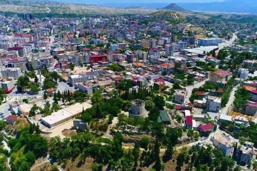
View of Mut district. (Mut Municipality)
The history of the district extends back to the 2000s BCE. It has been under the rule of various civilizations including the Hittites, Assyrians, Persians, Romans, Byzantines, Seljuks and Ottomans. During the Roman period it was known as Claudiopolis. Mut was captured by the Karamanids in 1225 and incorporated into Ottoman territory in 1473.
Mut district lies in the Göksu River valley on the southern foothills of the Taurus Mountains. The district features a combination of plains and mountainous areas. The Göksu River is the most important watercourse in the district. The Mediterranean climate prevails with hot dry summers and warm rainy winters.
According to the Turkish Statistical Institute’s 2023 data, the population of Mut district is 62,546. The majority of the population resides in the district center.
The district’s economy is based on agriculture and animal husbandry. Olive, apricot, almond, citrus and grape production are the main agricultural activities. Mut olive and Mut apricot are registered with geographical indication status. Small-scale animal husbandry and beekeeping are also among the economic activities carried out in the district.
The Alahan Monastery, built in the 5th century CE, is listed on UNESCO’s Tentative World Heritage List. The Karacaoğlan Tomb preserves the memory of the folk poet Karacaoğlan. Other historical structures in the district include Mut Castle, Alaaddin Mosque and Ballı Church.
Mersin Valiliği. "Mut." Accessed July 6, 2025. http://www.mersin.gov.tr/mut
Mersin İl Kültür ve Turizm Müdürlüğü. "Mut." Accessed July 6, 2025. https://mersin.ktb.gov.tr/TR-73145/mut.html
Mut Belediyesi. "Tarih." Accessed July 6, 2025. https://mut.bel.tr/sayfa/tarih
Mut Kaymakamlığı. "Nüfus ve Coğrafi Yapı." Accessed July 6, 2025. http://mut.gov.tr/nfus-ve-cografi-yapi
Mut Ticaret of Commerce and Industry. "Coğrafi Yapı." Accessed July 6, 2025. https://www.muttso.org.tr/Mut/Co%C4%9FrafiYap%C4%B1/tabid/17437/Default.aspx
Paintmaps. "Şehir Haritası Grafiği." Accessed July 6, 2025. https://paintmaps.com/tr/harita-grafikleri/sehir-haritasi-grafigi
Turkiye İstatistik Kurumu (TÜİK). "Adrese Dayalı Nüfus Kayıt Sistemi Sonuçları, 2023." Accessed July 6, 2025. https://www.tuik.gov.tr/
Mayor(s) | Volkan Şeker | ||||||||
|---|---|---|---|---|---|---|---|---|---|
Area(s)(Text) | 2.988 km² | ||||||||
Climate(s) | Mediterranean Climate | ||||||||
Elevation(s)(Text) | 300 m | ||||||||
Province(s) | Mersin | ||||||||
Historical Name | Claudiopolis | ||||||||
District | Mut | ||||||||
District Governor | İhsan Emre Aydın | ||||||||
Geographical Location(s) | Southern Slopes of the Taurus Mountains Göksu Valley | ||||||||
History
Geography and Population
Economy
Culture and Tourism
