


This article was automatically translated from the original Turkish version.
+2 More
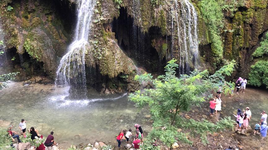
Kuzalan Falls
Location | Dereli Türkiye Giresun | ||||||||
|---|---|---|---|---|---|---|---|---|---|
Geological Feature | Travertine formations are observed. The rocks in the region consist of Paleozoic granites and granodiorites. | ||||||||
Kuzalan Waterfall is a waterfall located in the Black Sea Region of Türkiye, within the province of Giresun. It has a height of approximately 20 metres. The waterfall flows from a slope featuring travertine formations over the Aksu Stream. The travertines in the region formed through the precipitation of dissolved calcium carbonate from groundwater. Kuzalan Waterfall lies within the boundaries of the Kuzalan Waterfall Nature Park. The area is studied for its geomorphological structure, hydrological characteristics, and ecosystem.
Kuzalan Waterfall is situated within the boundaries of Dereli district in the province of Giresun, in Türkiye’s Black Sea Region. It is located approximately 700 metres south of Kuzalan Village, which is affiliated with Alancık Village. The distance from the provincial centre of Giresun is approximately 45 kilometres. The area lies along the Giresun-Dereli highway, surrounding the Aksu Stream valley. Geomorphologically and hydrologically, this area belongs to the interior zones of the Black Sea coastal belt and is notable for its steep valley structure.
Access to Kuzalan Waterfall is provided via the Giresun-Dereli highway. The road is suitable for vehicle traffic and follows the natural landscape of the valley. Paths leading to the waterfall have been planned with care to preserve the natural environment. Additionally, walking trails and nature routes in the area offer visitors various access alternatives.
The region primarily consists of Paleozoic granites and granodiorites. The valley and surrounding area of the Aksu Stream have been shaped by erosion and weathering of these hard rock formations. The area from which the waterfall flows is a slope rich in travertine deposits. Travertines form when dissolved calcium carbonate in groundwater emerges to the surface and precipitates, constituting a significant geological feature. These travertines are regarded as indicators of the region’s hydrogeological structure.
Kuzalan Waterfall and its surroundings exhibit geomorphological forms resulting from the interaction of the valley floor, slopes, and streams. The waterfall has a height of approximately 20 metres and was formed by the Aksu Stream flowing over a steep, travertine-covered cliff. The valley gradient, slope morphology, and stream regime directly influence the waterfall’s appearance and formation process. The area also shows clear signs of intense erosion.
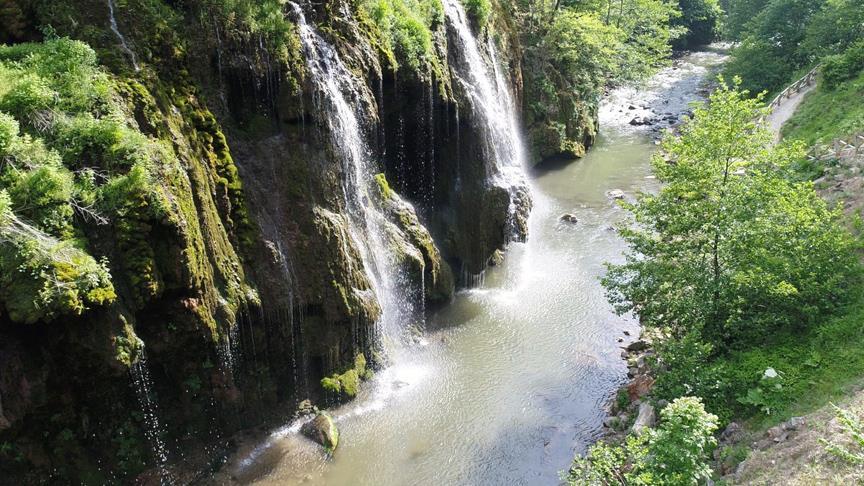
Kuzalan Şelalesi (Anadolu Ajansı)
Kuzalan Waterfall lies within the Black Sea climate zone. The annual average temperature is approximately 13.6 °C. The hottest month is July, with an average temperature of 22.2 °C, while the coldest month is January, with an average temperature of 5.1 °C. The average annual precipitation is 1235.2 mm, distributed relatively evenly throughout the year. November is the wettest month. The region has high humidity, which positively influences the diversity of its flora and fauna.
Class VII and VIII lands are common in the nature park and surrounding areas. This classification indicates limited suitability for agricultural production and high erosion risk. Soils are generally shallow, stony, and highly eroded. The most prevalent soil type is grey-brown podzolic soil. These soils are found in areas covered by forests, pastures, and partially by hazelnut orchards.
The area around Kuzalan Waterfall features a mixed vegetation type comprising both broadleaf and coniferous trees. Important plant communities include fir, beech, silver birch, black alder, wild cherry, wild hazelnut, and pure rhododendron species. Some individual trees are of monumental size and age. This floral diversity demonstrates the botanical value of the area. The region is suitable for botanical tours and nature studies.
The area is home to a wide variety of mammal, bird, reptile, rodent, and fish species. Among mammals are bear, roe deer, hare, wolf, fox, badger, pine marten, wildcat, and weasel. Bird species include crow, goshawk, sparrowhawk, golden eagle, buzzard, tawny owl, and nightjar, as well as wood pigeon, lesser spotted woodpecker, grey wagtail, crane, swan, duck, chaffinch, rock dove, partridge, and quail. Reptiles include the common European adder and the grass snake. Rodents such as mice and squirrels are widespread. Natural populations of brown trout, rainbow trout, carp, and barbel have been observed in the Aksu Stream and its tributaries.
Kuzalan Village is the nearest settlement to the waterfall. The name of the village means “area left in shadow,” reflecting its geographic position within the valley where sunlight exposure is limited. During summer months, the population increases temporarily due to seasonal activities such as hazelnut harvesting. In winter, the population declines significantly.
Within the boundaries of the nature park, there are two historic wooden watermills. These mills were constructed using a log-cabin system, with “hartama” roofing. These structures represent architectural examples of traditional rural life and livelihood in the region. Historically, the mills were used to grind produce from maize cultivation.
Kuzalan Waterfall and its surroundings provide opportunities for recreational activities such as nature walking, wildlife observation, birdwatching, and photography. The area also offers suitable environments for scientific research in disciplines including flora, fauna, geology, and hydrology. In this regard, it holds potential for ecotourism initiatives.
Kuzalan Waterfall lies within the boundaries of the Kuzalan Waterfall Nature Park, which was designated for the conservation of natural resources and sustainable use. The park’s management follows nature conservation principles with the aim of preserving ecosystem integrity.
Kuzalan Waterfall (Youtube/Giresun)
Dereli Kaymakamlığı. "Kuzalan Tabiat Parkı." Dereli Kaymakamlığı Resmi Web Sitesi. Accessed May 17, 2025.http://www.dereli.gov.tr/kuzalan-tabiat-parki
Giresun İl Directorate of Culture and Tourism. "Kuzalan Şelalesi ve Mavi Göl Tabiat Parkı." Giresun Provincial Directorate of Culture and Tourism Official Website. Accessed May 17, 2025.https://giresun.ktb.gov.tr/TR-184100/kuzalan-selalesi-ve-mavi-gol-tabiat-parki.html
Sezer, İbrahim. “Kuzalan Şelalesi Tabiat Parkı'nın Coğrafi Özellikleri ile Ekoturizm ve Rekreasyon Olanakları.” ResearchGate, 2017. Accessed May 17, 2025.https://www.researchgate.net/profile/Ibrahim-Sezer/publication/322050949_Kuzalan_Selalesi_Tabiat_Parki'nin_Cografi_Ozellikleri_Ile_Ekoturizm_Ve_Rekreasyo/links/62ae2f3923f3283e3af26df0/Kuzalan-Selalesi-Tabiat-Parkinin-Cografi-Oezellikleri-Ile-Ekoturizm-Ve-Rekreasyo.pdf
Yetgin, Gültekin. “Doğaseverlerin Uğrak Noktası Kuzalan Tabiat Parkı.” Anadolu Ajansı. Accessed May 17, 2025.https://www.aa.com.tr/tr/turkiye/dogaseverlerin-ugrak-noktasi-kuzalan-tabiat-parki/1236645
YouTube. "Kuzalan Tabiat Parkı - Giresun." Video, 4:32. Accessed May 17, 2025.https://www.youtube.com/watch?v=NWszMJfKilo

Kuzalan Falls
Location | Dereli Türkiye Giresun | ||||||||
|---|---|---|---|---|---|---|---|---|---|
Geological Feature | Travertine formations are observed. The rocks in the region consist of Paleozoic granites and granodiorites. | ||||||||
Location
Geological Features
Geomorphological Structure
Climate Characteristics
Soil Structure
Vegetation (Flora)
Animal Life (Fauna)
Human Environment
Cultural Features
Recreational and Scientific Use
Conservation Status