


This article was automatically translated from the original Turkish version.
+2 More
The Kula Volcanoes are located within the boundaries of Manisa province in western Anatolia, Türkiye. This area, situated on a plateau at an elevation of approximately 600–700 meters, is notable for its Quaternary-aged young volcanic rocks, volcanic cones, basaltic lava flows, maars【1】, hornitos【2】, and lava tubes. The region is one of Türkiye’s most significant areas from both geoscientific and geomorphological perspectives and includes the Kula-Salihli Geopark, Türkiye’s first and only UNESCO-recognized geopark.
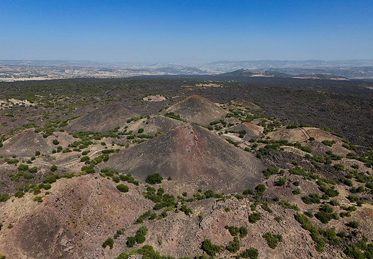
Kula Volcanic Hills (Anadolu Ajansı)
Geographically, the area lies within the Selendi Basin, situated between the Gediz and Simav graben systems. It extends across a plateau with an approximate elevation of 600–700 meters, bordered by the Gediz River to the north and the Alaşehir-Salihli (Gediz) Graben to the south. The volcanic formations are aligned parallel to the trend of these grabens, particularly in a northwest-southeast direction.
Geologically, the region is under the influence of the extensional tectonic regime of the Aegean. The Kula Volcanic Area is located between the metamorphic basement rocks of the Menderes Massif and the İzmir-Ankara Zone. Volcanism is driven by alkali basaltic magmas originating from the mantle, generated as a result of crustal thinning. These magmas reached the surface along fracture systems, producing lava flows, volcanic cones, and maars.
The surfaces on which volcanic activity occurred are primarily underlain by Paleozoic metamorphic rocks【3】, ophiolitic melanges【4】, and Neogene sediments【5】. The earliest volcanic deposits are represented by the Ahmetler and Ulubey formations, which consist of conglomerate【6】, sandstone, and lacustrine limestone units, with localized baked zones.
The tectonic structures controlling the development of Kula volcanism are associated with NW-SE trending fault systems. Volcanism along these fractures allowed lavas to reach the surface, forming various volcanic structures. Surface features such as cinder cones, spatter cones, and maars emerged as a result of these processes. The lavas predominantly exhibit ‘a’a’ flow characteristics, with secondary volcanic features such as hornitos and lava tubes observed locally.
The volcanic field spans an area approximately 30–35 kilometers long and 10–15 kilometers wide, extending from the center of Kula district to the Demirköprü Dam. Volcanic activity in this region occurred in three distinct phases, each represented by lava and pyroclastic【7】 deposits at different stratigraphic levels. The geological and geographical characteristics of the Kula Volcanic Area directly reflect the relationship between the regional volcanism and the tectonic regime.
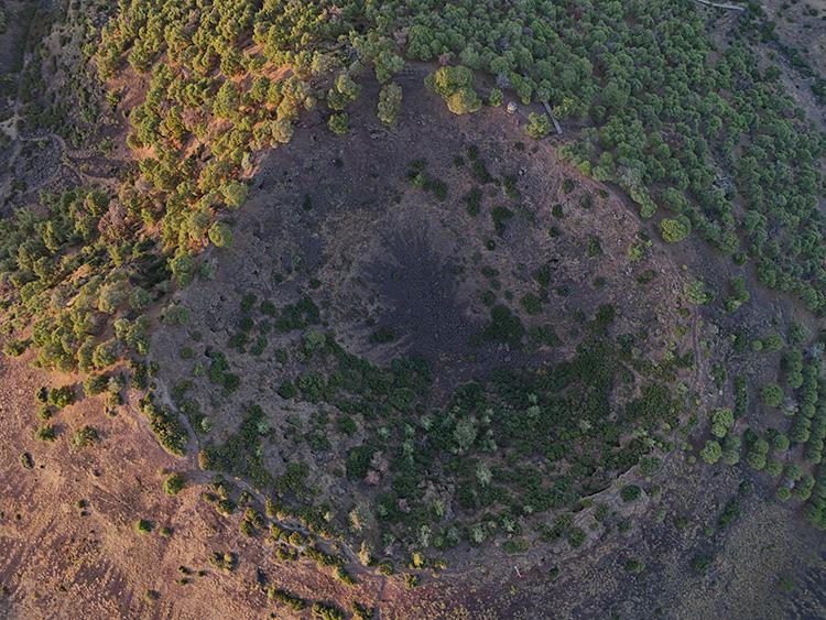
Divlit Crater (Anadolu Ajansı)
The Kula volcanic field is one of the youngest and most active volcanic areas in Türkiye during the Quaternary period. It is characterized by numerous volcanic cones, basaltic lava flows, maars, and pyroclastic deposits formed during multiple phases of volcanic activity. The region holds a unique position in Türkiye for its ability to represent different stages of volcanism geologically.
The volcanic process is divided into three main phases. The first phase, the Burgaz Phase, dates from approximately 1.94 to 0.99 million years ago and is represented by plateau basalts with well-developed columnar jointing, following weak explosive eruptions that produced cinder and ash layers. These lavas are dark-colored and massive, displaying well-preserved cooling columns at the surface. The second phase, the Elekçitepe Phase, occurred between approximately 300,000 and 50,000 years ago. During this period, monogenetic volcanism produced cinder cones and large-volume basaltic lava flows. Additionally, phreatomagmatic【8】 eruptions generated maar-type volcanoes and layered sedimentary structures known as ‘base surge’ deposits around them. The third and youngest phase, the Divlittepe Phase, dates from 25,000 to 4,000 years ago and is represented by clearly distinguishable ‘a’a’-type basaltic lava flows. These lavas are characterized by a broken, blocky, and porous surface, and the currently well-preserved volcanic cones also belong to this phase.
Approximately 80 cinder cones, 8 spatter cones, 5 maars, and 6 tumuli have been identified in the Kula Volcanic Area. These structures are of cinder and spatter type and exhibit varying morphological characteristics depending on their degree of erosion. Most cinder cones have gentle slopes, while some display double-crater structures on their flanks. Surface features such as hornitos and lava tubes are also common among the lava flows. Hornitos are small conical elevations formed by gas escape through the lava surface and provide important insights into lava flow dynamics.
Petrographically, the basalts in the region are alkaline in character and primarily composed of clinopyroxene, olivine, hornblende, plagioclase, and feldspathoid phenocrysts. Volume calculations indicate that cinder cones have an average basal diameter of 556 meters and a height of 45 meters, with a median volume of approximately 5.4 million cubic meters. The total volume of all volcanic products is estimated at about 5.9 km³, providing significant information on the size of eruption centers, eruption styles, and flow directions.
Kula volcanism is directly linked to extensional tectonic movements in western Anatolia. The region lies between the Menderes Massif and the İzmir-Ankara Suture Zone, where mantle-derived magmas ascended through fracture systems to form these volcanic fields. The sodium-rich composition of Kula basalts differs from the generally potassium-dominated volcanic series of western Anatolia, a feature associated with the rapid movement of the Aegean microplate over the African Plate.
The geological and volcanological diversity of the Kula Volcanic Area is of great importance not only for representing recent volcanic activity but also as a unique natural laboratory where petrographic, morphological, and tectonic features can be observed together.
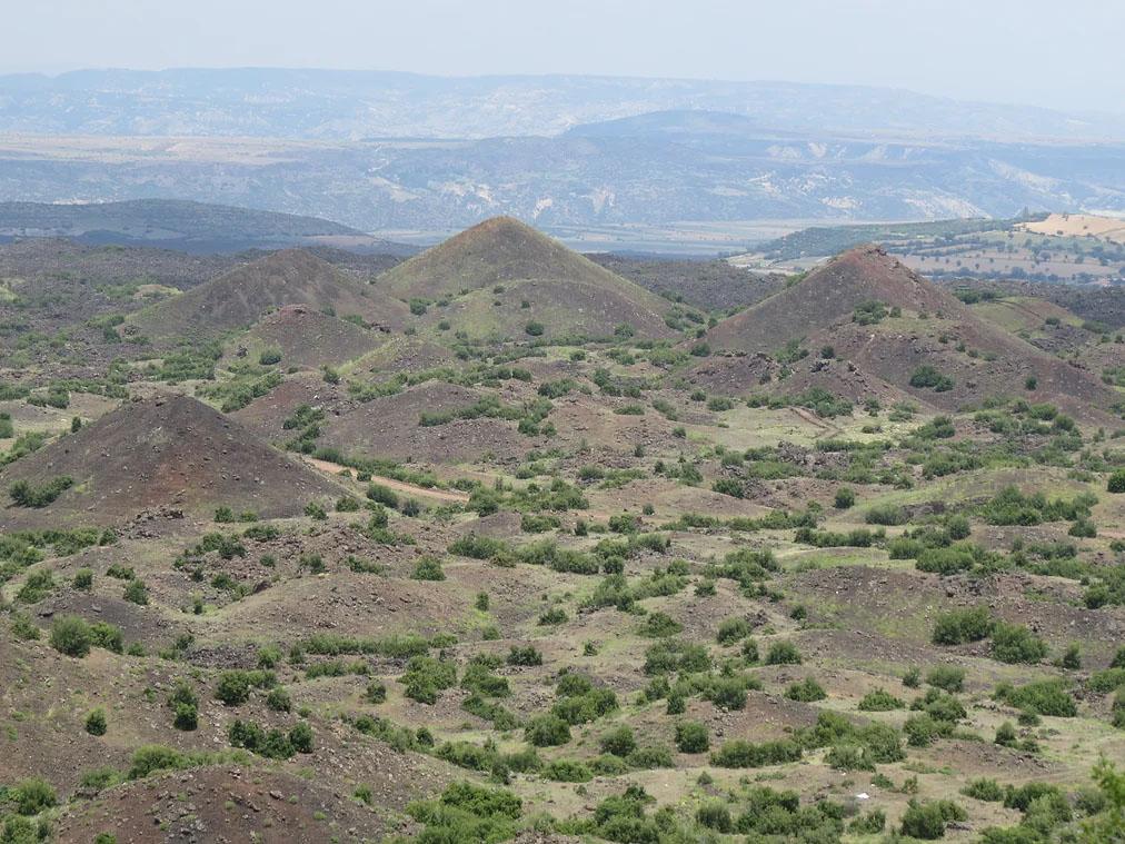
Volcanic Hills in Kula (MTA)
In antiquity, the region was referred to by Strabo as “Katakekaumene” (Burnt Land), indicating that volcanic activity was observed during historical periods. Additionally, prehistoric human footprints and handprints have been found on lava flows. Radiometric dating indicates these impressions date to the Bronze Age (3000–1200 BCE).
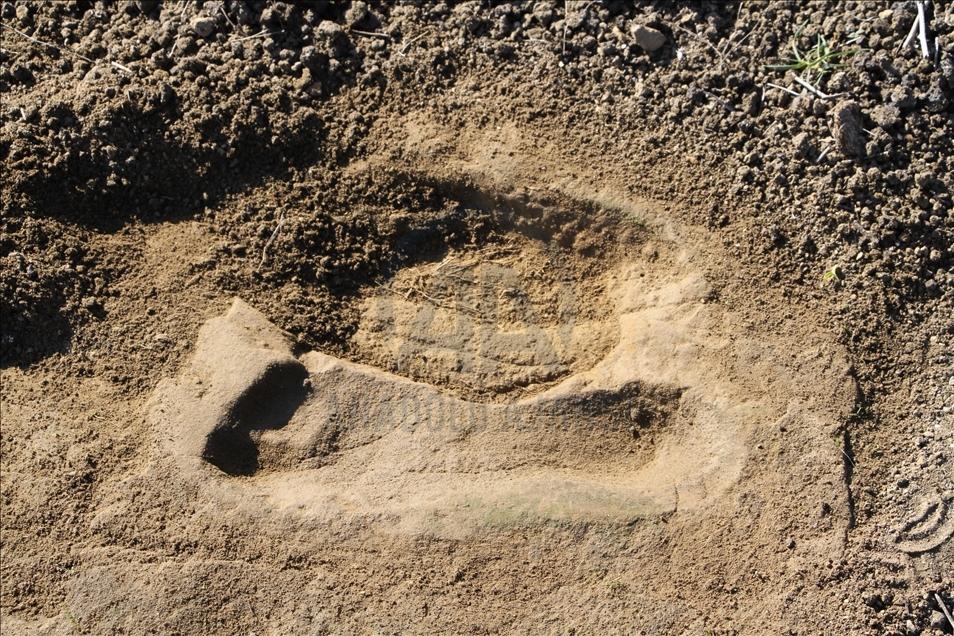
Found Footprint (Anadolu Ajansı)
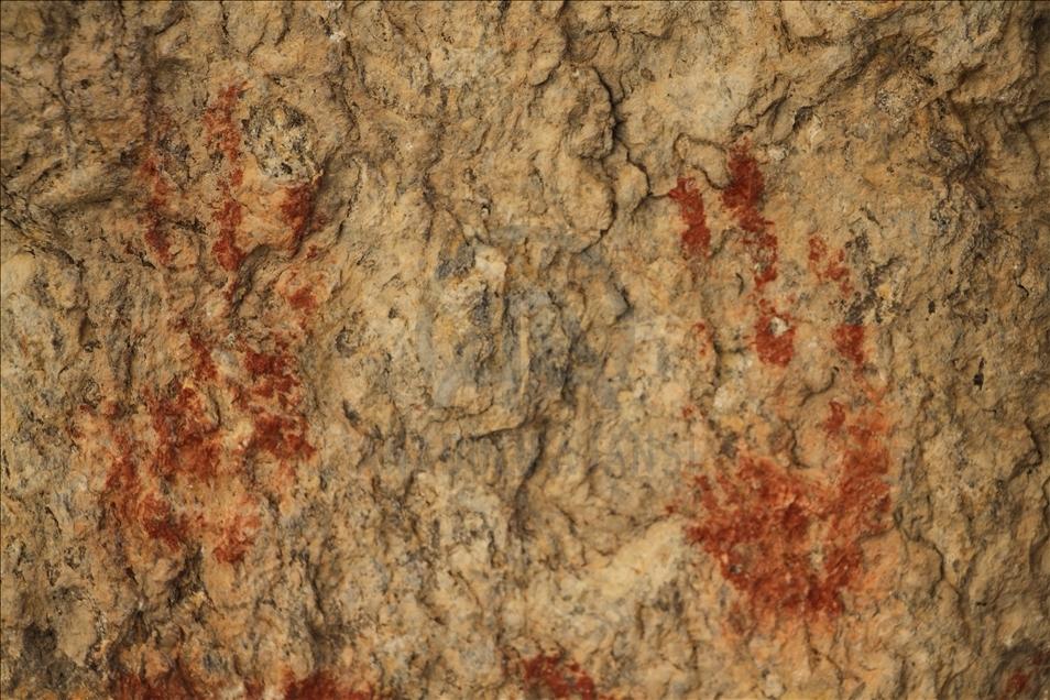
Found Footprint (Anadolu Ajansı)
In 2013, Kula was designated a UNESCO Global Geopark, becoming Türkiye’s first region to receive this status. The Kula-Salihli Geopark, covering approximately 930 km², represents not only its geological heritage but also the historical, cultural, and economic values of local communities at an international level.
The UNESCO Global Geopark status is awarded under a program aimed at conserving geologically significant areas, promoting their sustainable development, and raising awareness for scientific, educational, and cultural purposes. Launched in 2004 and formally integrated into UNESCO’s scientific programs in 2015, this designation seeks to support not only natural heritage but also local development visions.
The Kula-Salihli Geopark represents an important process in world history through its young volcanic structures. It offers an exemplary model through management plans for their conservation and through social, cultural, and economic projects developed in collaboration with local communities. The geopark area is not merely a nature conservation zone; it is also a site for scientific research, environmental education, and the sustainable promotion of nature-based tourism.
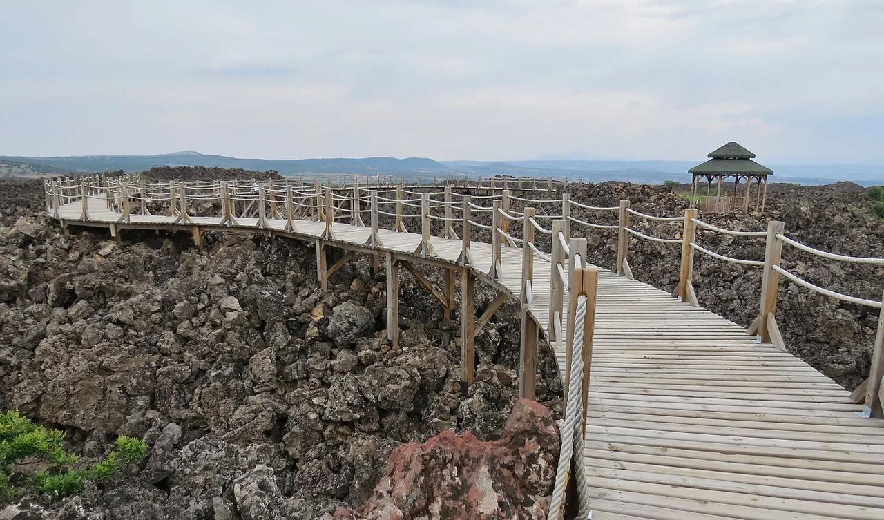
Kula Geopark Area (MTA)
Kula is one of the few areas in the world to have continuously recorded volcanic activity since the Early Pleistocene. Its multi-layered geological structure, extending from Paleozoic metamorphic rocks to prehistoric lava flows, serves as an important resource for academic research and earth science education. Kula, where human-nature interactions have been observed since antiquity, sheds light on cultural continuity through prehistoric footprints and historical descriptions.
Anadolu Ajansı. "Manisa'da 5 kilometre derinlikte keşfedilen magma odasında püskürme riski tespit edildi." Accessed April 24, 2025.Accessed adresi
Anadolu Ajansı. "Manisa'daki jeopark alanında ayak izi ve küllerin geçmişi araştırıldı." Accessed April 24, 2025.Accessed adresi
Aytaç, Ahmet Serdar, and Tuncer Demir. "Kula UNESCO Global Jeoparkı’nda Yerbilimleri ve Jeomiras Açısından Uluslararası Öneme Sahip Üç Yeni Jeosit Önerisi." *Mediterranean Journal of Humanities* 9, no. 2 (2019): 125–140.Accessed adresi
Ercan, Tuncay, and Önder Öztunalı. "Kula volkanizmasının Özellikleri ve İçerdiği 'Base Surge' Tabaka Şekilleri." Türkiye Jeoloji Kurumu Bülteni 25 (1982): 117–125.
Koçman, Asaf. "Yanık Ülke'nin Doğal Anıtları: Kula Yöresi Volkanik Oluşumları." Ege Coğrafya Dergisi 13 (2004): 5–15.Accessed adresi
Maden Tetkik ve Arama Genel Müdürlüğü. "Kula Volkanik Alanı." MTA. Accessed April 24, 2025.https://www.mta.gov.tr/turkvolc/tr/kula
Tokçaer, Murat, Samuele Agostini, and Mehmet Yılmaz Savaşçın. "Geotectonic Setting and Origin of the Youngest Kula Volcanics (Western Anatolia), with a New Emplacement Model." *Turkish Journal of Earth Sciences* 14, no. 2 (2005): 145–166.https://journals.tubitak.gov.tr/earth/vol14/iss2/2/
Türkiye Kültür Portalı. "Kula Volkanları - Manisa." Accessed April 24, 2025.https://www.kulturportali.gov.tr/turkiye/manisa/gezilecekyer/kula-volkanlari
Ulusoy, İnan, M.A. Sarıkaya, A.K. Schmitt, E. Şen, M. Danışık, and E. Gümüş. "Volcanic Eruption Eye-Witnessed and Recorded by Prehistoric Humans." *Quaternary Science Reviews* 212 (2019): 187–198.https://doi.org/10.1016/j.quascirev.2019.03.030
[1]
Jeolojik zaman cetvelinde en son ve en güncel dönemdir.
[2]
Patlamalı volkanik faaliyetlerle oluşan geniş ve çökük kraterlerdir.
[3]
Lav akıntıları üzerinde oluşan küçük koni biçimli gaz bacaları veya lav kabartılarıdır.
[4]
Önceden oluşmuş kayaçların yüksek sıcaklık, basınç ve/veya kimyasal etkilere maruz kalması sonucu yapı, doku ve/veya mineral bileşimlerinin değişmesiyle oluşan kayaçlardır.
[5]
Farklı yaş ve kökene sahip kaya parçalarının düzensiz biçimde bir araya gelerek oluşturduğu heerojen kaya topluluğudur.
[6]
Jeolojik zaman ölçeğinde üçüncül dönem içinde yer alır. Yaklaşık 23 milyon yıl önce başlayıp, 2.58 milyon yıl önce sona ermiştir.
[7]
İri taneli, çakıl boyutundaki taşların doğal bir çimento ile birbirine bağlanması sonucu oluşan tortul bir kayaç türüdür.
[8]
Volkanik patlamalar sırasında atmosfere fırlatılan ve daha sonra yere düşen katı veya yarı erimiş malzemeleri tanımlar.

Geographical and Geological Position
Volcanic Features
Historical and Cultural Context
UNESCO Global Geopark Status
Scientific and Cultural Significance