


This article was automatically translated from the original Turkish version.
+2 More
Karatepe-Aslantaş Açık Hava Müzesi is located within the boundaries of Kızyusuflu Village, Kadirli District, Osmaniye Province in southern Türkiye. It is situated 30 kilometers from the center of Osmaniye Province, 22 kilometers from the center of Kadirli District, and 130 kilometers from the center of Adana Province. The museum is built on a peninsula along the Ceyhan River, on the eastern shore of the Aslantaş Dam Lake, north of Karatepe at an elevation of 638 meters. In 1958, under Article 25 of Law No. 6831 on Forests and with the approval of the Ministry, an area of 7,715 hectares was declared a National Park. It is Türkiye’s first open-air museum.
Karatepe was constructed during the Late Hittite Period (8th century BCE) by King Azatiwata of the Kingdom of Adanawa as a frontier fortress against northern tribes. The fortress was known as Azatiwataya. It was captured and destroyed around 725–720 BCE by the Assyrian King Shalmaneser V or in 680 BCE by Esarhaddon.
The remains of Karatepe were accidentally discovered in 1946 by shepherds from Saimbeyli and reported to Naci Kum, Director of the Adana Museum, by teacher Ekrem Kuşçu. Excavations began in 1946 under the leadership of German archaeologist Prof. Dr. Helmuth Theodor Bossert and Halet Çambel. From 1952 onward, restoration and conservation work led by Halet Çambel ensured that the remains were preserved and displayed in situ. This approach established the first example of open-air museum practice in Türkiye.
The Karatepe-Aslantaş Fortress measures 195 meters from east to west and 375 meters from north to south. It is enclosed by double walls 2 to 4 meters thick. The height of the walls ranges from 4 to 6 meters. The walls are constructed of dry, mortarless stones filled with rubble and earth. The fortress is fortified by a total of 34 rectangular towers, 28 of which have been identified.
Inside the fortress are two monumental gates, one in the southwest and the other in the northeast. Both gates are built in a T-shape. Between them lies an open passageway, beyond which stands a monumental wooden gate that rotates on basalt pivot stones; passage through this gate leads to the courtyard and side chambers.
At the southwest gate, two lion statues made from broken fragments stand outside, while inside the gate, a three-meter-tall statue of the Storm God rests on a bull pedestal. The inner walls of the gate feature carved reliefs and bilingual inscriptions in the Phoenician alphabet and Hittite hieroglyphs.
At the northeast gate, two sphinxes with human heads and lion bodies face each other, along with a relief of the Sun God. This gate also contains bilingual inscriptions placed opposite each other.
Two large structural remains, believed to have been part of a palace, and storage pits have been found on the hilltop.
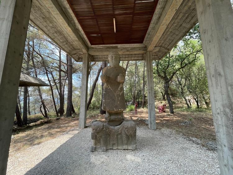
Osmaniye Arslantaş Açık Hava Müzesi (Anadolu Haber Ajansı)
The inscriptions at Karatepe-Aslantaş are written in Phoenician (alphabetic) and Luwian (Anatolian hieroglyphic) scripts and represent the longest known bilingual texts to date. These inscriptions have played a crucial role in deciphering the Hittite hieroglyphic writing system. For this reason, the Karatepe inscriptions are often compared to the Rosetta Stone, which aided in the decipherment of Egyptian hieroglyphs.
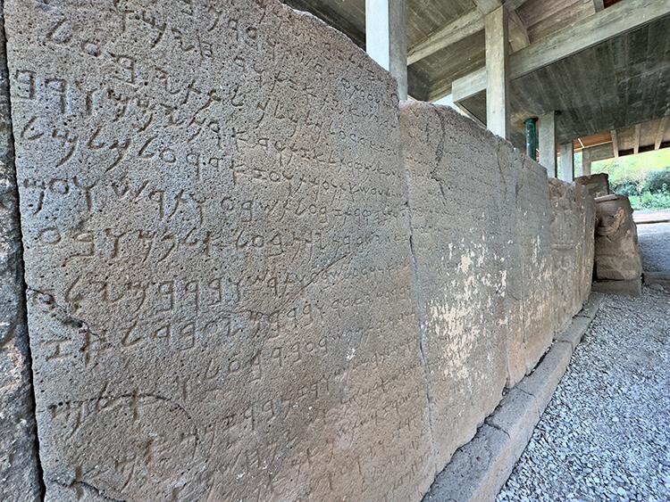
Osmaniye Antik kenti ( Anadolu Haber Ajansı )
Excavations were conducted in 1947 by Bossert and Bahadır Alkım. Restoration and conservation work began in 1952 under the leadership of Halet Çambel. Permanent protective shelters were constructed over the structures in 1957. Work resumed in 1987, during which damaged artifacts were re-erected. Because the remains were preserved in situ, the site was developed as an open-air museum. Additionally, an indoor museum section was opened in 2007.
Karatepe-Aslantaş National Park is located in the Mediterranean Region, on gently undulating terrain at the foothills of the Taurus Mountains where the Çukurova plain begins. The park includes the Aslantaş Dam and the Ceyhan River. The park area is surrounded by various streams including Hillik Creek, Kırağı Creek, Kışla Creek, and Kaplan Creek.
The significant hills within the national park are:
This peninsula, surrounded by the dam lake, possesses both natural and cultural landscape value due to its rich flora and natural forest cover.

Osmaniye Arslantaş Açık Hava Müzesi (Anadolu Haber Ajansı )
Access to the Karatepe-Aslantaş Open-Air Museum is provided via asphalt roads. The museum is connected to the provinces of Adana and Osmaniye and is visited daily by both domestic and international tourists, especially during the summer months.
The Karatepe-Aslantaş Archaeological Site was added to the UNESCO World Heritage Tentative List in 2020.
Ministry of Culture and Tourism of the Republic of Türkiye. "Karatepe Aslantaş Open-Air Museum." Türkiye Kültür Portalı. Accessed May 10, 2025.https://www.kulturportali.gov.tr/turkiye/osmaniye/gezilecekyer/karatepe-aslantas-acik-hava-muzesi
Osmaniye Valiliği. "Karatepe Müzesi." Accessed May 10, 2025.http://osmaniye.gov.tr/karatepe-muzesi.
Osmaniye İl Directorate of Culture and Tourism. "Karatepe -Aslantaş Açık Museum." Accessed May 10, 2025.https://osmaniye.ktb.gov.tr/TR-161049/karatepe—aslantas-acik-hava-muzesi.html
Republic of Türkiye Ministry of Culture and Tourism. “Osmaniye Karatepe Aslantaş Örenyeri.” Turkish Museums. Accessed May 10, 2025.https://www.turkishmuseums.com/museum/detail/2218-osmaniye-karatepe-aslantas-orenyeri/2218/1
T.C. Kültür ve Turizm Bakanlığı. "Karatepe Aslantaş Açık Hava Müzesi." Müze.gov.tr. Accessed May 10, 2025.https://muze.gov.tr/muze-detay?sectionId=OKA01&distId=MRK

No Discussion Added Yet
Start discussion for "Karatepe Arslantaş Open-Air Museum" article
History
Architectural Features and Structures
Inscriptions and Linguistic Significance
Excavation and Conservation Activities
Natural Environment and National Park Status
Access and Visitation
UNESCO Tentative List