


This article was automatically translated from the original Turkish version.
+1 More
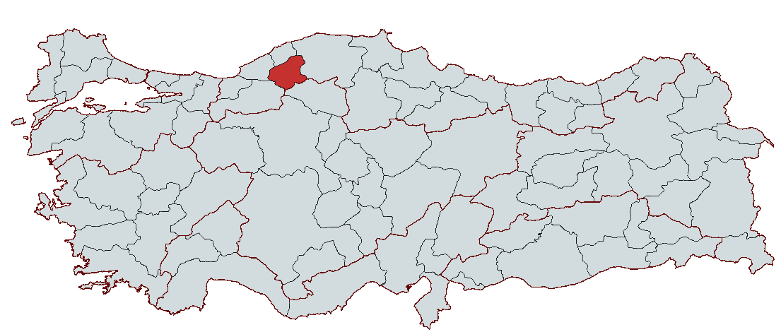
Karabük
Country | Türkiye | ||||||||
|---|---|---|---|---|---|---|---|---|---|
Region | Western Black Sea Region | ||||||||
Population | 250.478 | ||||||||
Area | 760 km² | ||||||||
Climate | Black Sea Climate | ||||||||
Important Structure | Cinci Han and Hamam Hadrianapolis Ancient City Safranbolu Houses İzzet Mehmet Paşa Camii | ||||||||
Area Code(s) | 370 | ||||||||
License Plate | 78 | ||||||||
Governor | Mustafa Yavuz | ||||||||
Mayor | Özkan Çetinkaya | ||||||||
Karabük is a city located in the Western Black Sea Region of Western Karadeniz Bölgesi and has grown rapidly due to industrialization. It became an industrial center with the establishment of Kardemir Iron and Steel Factory in 1937, Türkiye’s first major industrial initiative, and attained provincial status in 1995, becoming Türkiye’s 78th province. Throughout history, Karabük, situated within the region of Paphlagonia, has been home to various civilizations from the Hittites to the Byzantines and from the Ottomans to the present day. Safranbolu, like other cultural heritage sites on the UNESCO World Heritage List, preserves its historical fabric and stands out for its cultural heritage. Karabük also possesses tourism potential through its natural beauty, canyons, and caves. The city, with its extensive forest areas, has an advanced economic structure based on forest products, iron and steel industry, and education. With the opening of Karabük University, the city has experienced growth in terms of education and student population and holds an important position as a center where industry, culture, and nature tourism converge.
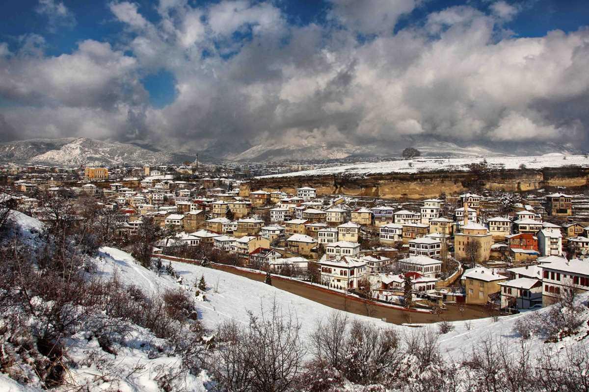
Safranbolu Houses
Karabük derives its name from the geographical characteristics of the area. The word Karabük is formed by the combination of “kara” and “bük,” meaning “black shrubland place.” Throughout history, the city has hosted various civilizations and, with the industrialization drive of the 20th century, became one of Türkiye’s most important industrial cities.
Although numerous höyük and tumuli from prehistoric periods have been found in and around Karabük, no systematic archaeological excavation has been conducted in these areas. However, surface surveys indicate that the region’s history extends back to the Early Bronze Age (circa 2500 BCE). In particular, the village of Yazıboy in Eskipazar district stands out as one of the oldest settlement sites in the region.
In antiquity, Karabük and its surroundings came under the rule of the Phrygians, Hellenistic kingdoms, and the Roman Empire after the Hittites. During the Hittite period, Eflani was one of the most important settlements in the region. Hittite sources refer to the town as “Haluna.” During the Phrygian period, Kışlaköy in Ovacık district became a significant settlement. In the Hellenistic period, the Kingdom of Bithynia used the region as a base to defend against the Roman Empire.
During the Roman period, Karabük and its surroundings became an important settlement and trade center. The most important Roman cities in the region were Hadrianapolis and Kimistene, located within the boundaries of today’s Eskipazar district. Hadrianapolis, one of the most significant Roman settlements in Western Black Sea Region, is notable for its mosaics and church remains.
Roman dominance in the region continued after the foundation of the Byzantine Empire in 395 CE. In the 10th century, the Byzantine Empire resettled various peoples in Anatolia to counter population loss. During this period, Turkic tribes such as the Pechenegs, Cumans (Kipchaks), and Uzes, who had adopted Christianity, were relocated to the Karabük region. As a result of this settlement policy, areas such as Eskipazar and Eflani began to undergo Turkification during the Byzantine era.
After the Battle of Manzikert in 1071, the Seljuk commander Emir Karatekin captured Çankırı in 1082 and took control of the cities in and around Karabük. In 1084, Eflani and Safranbolu came under the control of the Anatolian Seljuk State. With the weakening of the Anatolian Seljuk State, the region fell under the rule of the Candaroğulları Beylik. The Candaroğulları were especially influential in Safranbolu and its surroundings. In 1392, Ottoman Sultan Yıldırım Bayezid incorporated the territories of the Candaroğulları into the Ottoman Empire, bringing Karabük and its surroundings under Ottoman rule.
During the Ottoman period, Karabük continued as a village under Safranbolu. In the 17th century, Safranbolu became one of the key centers of the Ottoman economy due to its location along major trade routes and developed into a significant settlement. Safranbolu became particularly renowned for its Ottoman wooden architecture and gained fame for its traditional Turkish houses. Karabük, however, remained a small village during this period. However, as the Ottoman Empire expanded its trade routes, economic activity increased in Safranbolu and its surroundings, and Karabük gradually began to gain importance.
Karabük’s destiny changed fundamentally during the Republican era. With the opening of the Ankara-Zonguldak railway in 1935, Karabük emerged from being a small village and acquired a strategic position in terms of transportation. On 3 April 1937, under the industrialization policy of Mustafa Kemal Atatürk, İsmet İnönü laid the foundation stone of the Karabük Iron and Steel Factory. This facility, Türkiye’s first integrated iron and steel plant, is regarded as one of the most important steps in the country’s heavy industry initiative. With the establishment of the iron and steel plants, Karabük rapidly expanded, attracted migration, and became one of Türkiye’s major industrial cities. As the population grew, Karabük Municipality was established on 25 June 1939, and on 3 March 1953, Karabük gained district status under Zonguldak Province. On 6 June 1995, a decree published in the Official Gazette merged the districts of Ovacık and Eskipazar from Çankırı and Eflani, Safranbolu, and Yenice from Zonguldak to form Karabük Province, making it Türkiye’s 78th province.
Today, Karabük continues as one of Türkiye’s important cities due to its industry, historical fabric, and natural beauty. In particular, the Kardemir Iron and Steel Factory continues to shape the city’s economic and social structure. In addition, Safranbolu, with its Ottoman-era architecture, has been included in the UNESCO World Heritage List and has gained significant importance in tourism.
Karabük is a city located in the Western Black Sea Region of Türkiye that has developed rapidly alongside industrialization. Its location, landforms, climate, and natural resources give it both strategic and natural significance.
Karabük lies between 41° 11' and 41° 34' north latitudes and 32° 04' and 33° 06' east longitudes. Located in the northwestern part of Türkiye, Karabük is situated in the inland areas of the Western Black Sea Region.
The city center is situated at approximately 270 meters above sea level and features a rugged terrain.
Karabük’s climate exhibits characteristics of the intersection between the Black Sea and continental climates. The northern regions near the Western Black Sea coast experience a milder and wetter climate due to Black Sea influence. In the inland and higher altitude areas, the continental climate dominates, with hot and dry summers and cold, snowy winters.
The annual average temperature is around 13–14°C. Summer temperatures can reach 30°C, while winter temperatures can drop to -10°C. Although rainfall distribution is irregular, precipitation is higher in autumn and winter. Snowfall commonly occurs between December and March.
Karabük’s landforms are highly diverse and generally consist of mountains, plateaus, and valleys.
The elevation at the city center is approximately 270 meters, while in districts such as Yenice, Eflani, and Ovacık, elevations reach up to 1,500 meters.
Karabük is particularly rich in underground resources, especially iron ore and forest areas.
Although Karabük’s agricultural land is relatively limited, it is a rich city in terms of forest products and industrial raw materials.
Karabük has numerous rivers, with the Filyos River and its tributaries being the most significant. The main water sources are:
Although there are no large-scale dams in the city, small reservoirs exist to meet agricultural irrigation and drinking water needs.
Although Karabük is located near the North Anatolian Fault Line, it is not classified as a first-degree earthquake zone. However, due to its proximity to the Kastamonu and Zonguldak regions in Western Black Sea, it faces a moderate earthquake risk. Although no major destructive earthquakes have occurred in Karabük throughout history, earthquakes in neighboring provinces have been felt in the city. Due to the solid ground structure in Karabük, major damages are rarely observed. Karabük stands out as a city with diverse climate and geographical structure, rich underground resources, and low earthquake risk.
Karabük’s economic structure consists of various sectors including industry, trade, agriculture, forestry, and tourism. The city industrialized and developed its growth based on the Kardemir Iron and Steel Factory, Türkiye’s first major heavy industry investment. In addition, Safranbolu’s cultural heritage supports tourism, extensive forested areas provide opportunities for forestry and wood industries, and agricultural activities remain a livelihood source in rural areas.
Karabük’s industry is built around iron and steel production and related secondary industries. KARDEMİR, Türkiye’s first iron and steel factory, is the main pillar of the city’s economy.
KARDEMİR was established in 1937 and remains one of Türkiye’s most important iron and steel producers. After privatization in 1995, KARDEMİR continues to directly employ 4,111 people and remains the locomotive of the city’s economy. In addition to KARDEMİR, more than 45 small and medium-sized iron and steel production facilities operate in the city’s industrial zones.
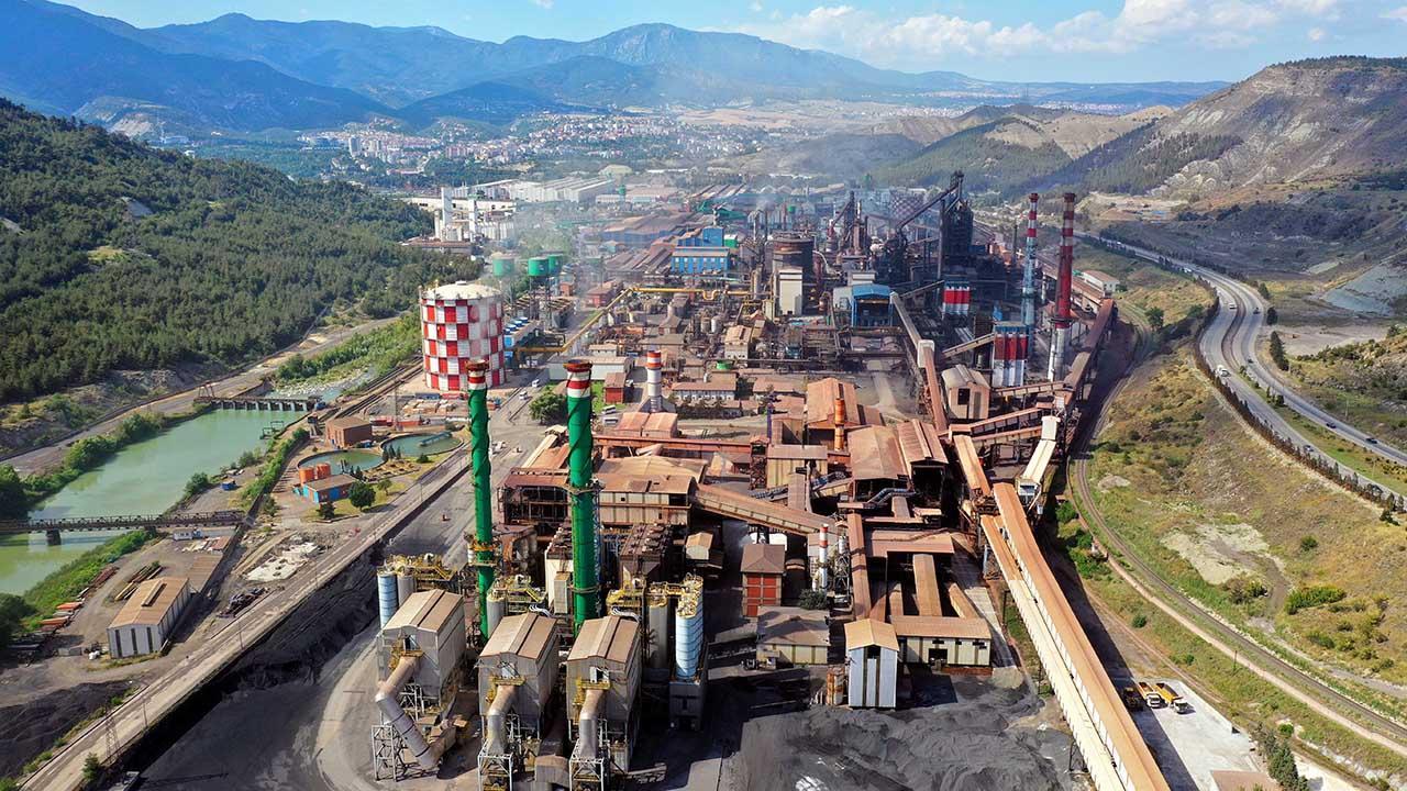
Karabük Iron and Steel Factory (Source: AA)
Karabük has two Organized Industrial Zones (OIZ) and three Small Industrial Sites supporting industrial development.
Karabük is a city where industry and trade are closely intertwined. Trade in raw materials and by-products related to iron and steel production holds a significant place.
Twenty-two point four percent of Karabük’s area is agricultural land. Although agriculture constitutes a small part of the city’s economy, it remains a vital livelihood source for rural populations.
According to TÜİK’s official data, Karabük Province’s population has shown a gradual increase in recent years. Based on the most recent data (2022–2023), the total population of Karabük Province is approximately 250,000 to 255,000. About 75–77% of this population resides in urban settlements (e.g., Karabük Central District), while the remainder lives in rural areas (districts such as Eflani, Eskipazar, Ovacık, Safranbolu, and Yenice). With a total area of approximately 4,142 km², the population density is around 60 people per km².
The province consists of six districts (Karabük Central, Eflani, Eskipazar, Ovacık, Safranbolu, and Yenice). Following industrialization, particularly with the establishment of Kardemir, Türkiye’s first iron and steel factory, significant migration occurred toward the center, attracting young and educated labor. This situation led to the emergence of a young and dynamic population structure in the province. Gender distribution is generally balanced, with nearly equal male and female ratios. However, in some districts, particularly more rural areas (e.g., Ovacık), population decline has been observed, a result of internal migration toward urban centers.
Administratively, Karabük consists of six districts.
Karabük’s cultural and natural heritage holds significant tourism potential. Safranbolu, after being included in the UNESCO World Heritage List, has become a major contributor to the tourism economy.
Thanks to tourism, sectors such as accommodation, restaurant management, handicrafts, and souvenir trade have developed.
Karabük is an important logistics center due to its railway and road connections to Ankara and Zonguldak.
Karabük’s economy is largely based on industry. KARDEMİR and its related iron and steel industries constitute the largest share of the provincial economy, while tourism, forestry, and services enhance economic diversity. Agriculture and livestock, although relatively small-scale, continue to serve as livelihood sources in rural areas. With industrial investments, tourism development, and strengthened transportation infrastructure, Karabük’s economy has significant future growth potential.
Karabük’s infrastructure has developed in parallel with its industrialization and urbanization, advancing in areas such as modern transportation, education, health, and energy. The city’s infrastructure was initially shaped to meet the needs of the iron and steel industry, and in recent years has expanded into a broader structure due to university development and tourism growth.
Karabük’s intra-city transportation varies due to differences between newly developed urban areas and older settlements.
Intra-city transportation is provided by minibuses and private municipal buses. Special routes have been established for student transportation following the establishment of Karabük University. Regular minibus services operate between Safranbolu and other districts.
Karabük is connected by road to major cities such as Istanbul and Ankara. Integrated into the national transportation network via the D-755 Highway and the Gerede-Ankara Motorway, roads in inland areas have been widened and modernized.
Regular bus services connect Karabük to Ankara, Istanbul, Kastamonu, Zonguldak, and Bolu. The bus terminal is located in the city center, with transportation provided by minibuses and taxis.
Karabük is located on the Ankara-Zonguldak railway line, one of Türkiye’s major rail networks. Due to iron and steel production, rail transport plays a vital role in freight movement. The train station, located 2 km from the city center, provides direct access to Ankara and Zonguldak.
Karabük has no airport. The nearest airport is Ankara Esenboğa Airport (240 km away). Regular bus services connect Safranbolu and Karabük to the airport for travel to Ankara and Istanbul.
With the establishment of Karabük University (KBÜ) in 2007, Karabük has strengthened its educational infrastructure and become an important educational center in the region.
With a capacity of 52,771 students, it is the largest educational institution in the region. It serves with 955 academic and 459 administrative staff. The modern campus is equipped with a library, laboratories, sports halls, and student dormitories. It is notable for departments such as the Faculty of Technology, Faculty of Engineering, and Faculty of Health Sciences.
There are 195 schools in Karabük. 37,255 students receive education in 2,133 classrooms. There are 14 private schools, 9 driver training courses, 14 various courses, and 6 special rehabilitation centers.
Vocational high schools oriented toward industry are widespread in Karabük. Institutions providing technical education to train personnel for the iron and steel industry are present.
Karabük has improved health services in the region and established a significant infrastructure primarily through public health services.
Karabük Education and Research Hospital (serves as a State Hospital). Private hospitals and medical centers (e.g., Özel Medikar Hospital). Family health centers and district health clinics are available. Health services have been strengthened with academic support from the university hospital.
Thermal sources in Karabük and Safranbolu are being developed for health tourism. Healthy living centers and alternative medical practices using natural products are becoming widespread.
As an industry-based city, Karabük has high energy demands, and infrastructure projects are implemented in integration with industry.
Karabük has strengthened its electricity infrastructure to meet industrial needs. Natural gas infrastructure is largely completed in the city center.
The city has water treatment facilities. Waste management and recycling projects are increasingly widespread.
Since the 1950s, unplanned urbanization has occurred in Karabük due to increasing migration, but in recent years urban transformation projects have brought modern urban planning to the forefront.
Urban transformation projects are being implemented by TOKİ in neighborhoods such as Cevizlidere, Fatih, and Soğuksu. Transformation and infrastructure improvement works continue in areas with high concentrations of informal settlements.
Karabük’s infrastructure has developed through an industry-based urbanization model and is supported by modern transportation, education, and health facilities. Railway and road connections are strong, health infrastructure is adequate, and energy and urban transformation projects are progressing. Karabük University and Safranbolu’s tourism potential have accelerated the modernization and expansion of infrastructure. In the coming years, industrial investments and urban transformation projects are expected to further enhance the city’s infrastructure.
Karabük cuisine is a rich culinary tradition reflecting the traditional cuisine of Western Black Sea, with traces of Ottoman and Turkmen culinary influences. In particular, Safranbolu cuisine, influenced by its location on the historic Silk Road, offers a wide variety of dishes. The city’s cuisine reflects traditional Anatolian cuisine based on agriculture and livestock, consisting of nutritious and filling dishes made from local herbs, cereals, and meat products.
Soups hold an important place in Karabük cuisine. Nutritious and filling soups, often consumed in winter, are based on cereals and legumes.
In Karabük cuisine, meat dishes are typically prepared with lamb and beef. Kebab varieties and pot dishes reflect Black Sea culinary influences.
Karabük cuisine is rich in dough dishes, typically prepared as oven dishes.
Vegetable dishes are widely consumed in Karabük cuisine, especially during winter months.
Desserts hold an important place in Karabük cuisine, with Safranbolu’s famous desserts attracting particular attention.
Karabük cuisine offers a rich flavor world blending Ottoman, Turkmen, and Black Sea culinary traditions. Cereals, vegetables, meat dishes, and especially saffron-based flavors form the core components of its cuisine. The culinary culture, combined with Safranbolu’s tourism identity, offers unique contributions to traditional Turkish cuisine through dishes such as saffron pilaf, safranlı zerde, and bükme.
Karabük possesses significant cultural and architectural heritage from the Paphlagonia region. The city contains numerous artifacts from the Roman, Byzantine, Seljuk, and Ottoman periods. In particular, the district of Safranbolu resembles an open-air museum with its Ottoman-era houses, mosques, caravanserais, baths, and bazaars. Safranbolu, listed on the UNESCO World Heritage List, is recognized as one of the world’s best-preserved cities due to its preserved Ottoman architecture.
Hadrianapolis is an important settlement from the Roman period, known as “Paphlagonia Hadrianapolis.” The ancient city lies within the boundaries of Budaklar, Büyükyaylalar, Çaylı, and Beytarla villages in Eskipazar district. Three Early Byzantine churches are located within the settlement. The site features church mosaics, rock tombs, and cisterns. The mosaics depict the four rivers of paradise (Phison, Geon, Euphrates, Tigris) according to Christian belief. Hadrianapolis is an archaeological center offering important insights into early Christianity in the Black Sea region.
Located near Safranbolu district in Karabük, Bulak Cave is one of the largest caves in the Black Sea region.
Of its 6.5 km length, 380 meters are open to tourism. Inside, there are underground rivers, lakes, waterfalls, and stalactite-stalagmite formations. Registered as a natural heritage site, it is open to visitors.
Cinci Han was built in 1645 by Karabaşzade Hüseyin Efendi (Cinci Hoca). Due to its location on the Silk Road, it served as an important accommodation for merchants. In the 20th century, it was restored and began operating as a hotel, restaurant, and café. It is a two-story structure with 63 rooms.
Built in 1661 by Grand Vizier Köprülü Mehmet Paşa. It has a square plan and follows traditional Ottoman mosque architecture. The mosque courtyard features a şadırvan and a sundial. Restoration was completed in 2019 and it reopened for worship.
Built in 1796 by Ottoman Grand Vizier İzzet Mehmet Paşa. Designed as a smaller model of the Nuruosmaniye Mosque. Its interior, featuring calligraphy, mihrab, and minbar, is notable. The tughra of Sultan III. Selim is located inside the mosque.
The İncekaya Water Channel was built in the 18th century by Grand Vizier İzzet Mehmet Paşa. It is 116 meters long and 60 meters high. Constructed to meet Safranbolu’s water needs, it now lies above Tokatlı Canyon and serves as a tourist attraction.
Built in the 17th century by Cinci Hüseyin Hoca, it is one of the important examples of Ottoman bath architecture. It has separate sections for women and men. It belongs to the cross-vaulted bath group and was built in the name of Cinci Hoca’s mother, Hamide Hatun. It currently operates actively.
Yemeniciler Arastası, the traditional commercial center of Safranbolu, was a bazaar during the Ottoman period specializing in shoemaking and leatherwork. Adjacent to Köprülü Mehmet Paşa Mosque, it consists of 48 wooden shops. Built according to the traditional guild system, it has been restored and now functions as a tourist bazaar.
Safranbolu is one of the best-preserved examples of Ottoman civil architecture and is listed on the UNESCO World Heritage List. There are 1,457 registered Ottoman mansions. It reflects the finest examples of traditional Turkish housing architecture. Wooden carvings, stone foundations, and gabled roofs are distinctive features.
Yörük Village is a small-scale model of Safranbolu and was declared a protected site area in 1997. It is one of the most important representatives of Yörük culture in Anatolia. Wooden mansions built in accordance with Ottoman architecture are present. Traditional Turkish houses such as the Sipahioğlu Mansion are open to visitors.
One of Safranbolu’s most famous natural beauties, formed by erosion of limestone layers. It features a walking trail approximately 9 km long. Inside, the İncekaya Water Channel and Crystal Glass Terrace are located.
Located along the Karabük-Yenice road, Şeker Canyon is suitable for outdoor sports. It features steep cliffs 100–250 meters high. It is ideal for rafting, camping, rock climbing, and bicycle tours. Karabük possesses a rich historical heritage extending from antiquity to the Ottoman period. In particular, Safranbolu district is recognized as one of the best-preserved Ottoman cities in both Türkiye and the world, serving as an important cultural heritage site. With its ancient ruins, Ottoman-era bazaars, caravanserais, mosques, and natural beauties, Karabük is a city where history and nature are intertwined.
Karabük’s administration has been conducted by governors and municipal mayors in line with Türkiye’s administrative structure since 1923. After attaining provincial status in 1995, Karabük has been governed by governors representing the central government and municipal mayors leading local administration.
When Karabük attained provincial status in 1995, it was formed by merging districts separated from Çankırı and Zonguldak provinces. Since then, the Karabük Governorship has been managed by governors appointed by the Ministry of Interior.
The municipal organization in Karabük was established on 25 June 1939. In 1941, Karabük was a sub-district under Safranbolu district; it gained district status in 1953 and became Türkiye’s 78th province in 1995. Municipal administration developed alongside urbanization and expanded significantly with industrialization following the establishment of Kardemir. Urban planning, housing projects, and infrastructure works have been carried out by municipalities in response to industrialization.
In the 2024 local elections, AK Party candidate Özkan Çetinkaya won the mayoral position with 33.71% of the vote and assumed office. Prior to the election, MHP’s Rafet Vergili, who held the mayoral position, received 26.28% of the vote and came in second. In other districts of Karabük, Hüsnü Akın of MHP won in Eflani, Serkan Cıva of AK Party in Eskipazar, Ahmet Şahin of AK Party in Ovacık, Elif Köse of CHP in Safranbolu, and Şekip Sertaş Karakaş of AK Party in Yenice.
Karabük Belediyesi. "Resmi Web Sitesi." Accessed February 17, 2025.https://www.karabuk.bel.tr/default.asp.
Karabük Valiliği. "Resmi Web Sitesi." Accessed February 17, 2025.http://www.karabuk.gov.tr/.
Türkiye Diyanet Vakfı İslam Ansiklopedisi. "Karabük." Accessed February 17, 2025.https://islamansiklopedisi.org.tr/karabuk.
Türkiye Kültür Portalı. "Karabük Genel Bilgiler." Accessed February 17, 2025.https://www.kulturportali.gov.tr/turkiye/karabuk.
Karabük
Country | Türkiye | ||||||||
|---|---|---|---|---|---|---|---|---|---|
Region | Western Black Sea Region | ||||||||
Population | 250.478 | ||||||||
Area | 760 km² | ||||||||
Climate | Black Sea Climate | ||||||||
Important Structure | Cinci Han and Hamam Hadrianapolis Ancient City Safranbolu Houses İzzet Mehmet Paşa Camii | ||||||||
Area Code(s) | 370 | ||||||||
License Plate | 78 | ||||||||
Governor | Mustafa Yavuz | ||||||||
Mayor | Özkan Çetinkaya | ||||||||
History
Prehistoric and Ancient Periods in Karabük
Byzantine and Pre-Turkish Period
Seljuk and Beylik Periods
Ottoman Period
Republican Era and Industrialization
Geographical Structure
Location and Boundaries
Climate
Landforms
Natural Resources and Minerals
Rivers and Dams
Seismic Activity
Economic Structure
Industry and Production
Karabük Iron and Steel Industry
Organized Industrial Zones (OIZ) and Small Industrial Sites
Trade and Service Sector
Agriculture and Livestock
Main Agricultural Products
Livestock and Forestry
Demographic Structure
Districts
Tourism and Cultural Economy
Elements Contributing to Tourism Economy
Transportation and Logistics
Infrastructure
Intra-City Transportation
Public Transportation
Road Network
Inter-City Transportation
Road
Railway
Air
Universities and Educational Infrastructure
Karabük University (KBÜ)
Primary and Secondary Education
Vocational and Technical Education
Health Infrastructure
Hospitals and Health Facilities
Health Tourism
Energy and Infrastructure Projects
Electricity and Natural Gas
Water and Waste Management
Urbanization and Urban Transformation
New Settlement Areas
Urban Transformation Projects
Cuisine
General Characteristics of Karabük Cuisine
Traditional Dishes
Soups and Starters
Meat Dishes and Kebabs
Dough and Cereal Dishes
Vegetable and Legume Dishes
Desserts and Saffron Use
Traditional Beverages
Historical Structures
Ancient Structures
Hadrianapolis Ancient City (Eskipazar)
Bulak / Mencilis Cave (Safranbolu)
Historical Structures from the Ottoman Period to the Present
Cinci Han (Safranbolu)
Köprülü Mehmet Paşa Mosque (Safranbolu)
İzzet Mehmet Paşa Mosque (Safranbolu)
Water Channels and Historical Fountains
İncekaya Water Channel (Safranbolu)
Baths and Bazaars
Cinci Hamam (Safranbolu)
Yemeniciler Arastası (Safranbolu)
Traditional Ottoman Houses and Urban Heritage
Safranbolu Houses
Yörük Village
Natural and Historical Sites
Tokatlı Canyon
Şeker Canyon
Administration
Governorship
Municipal Administration