


This article was automatically translated from the original Turkish version.
+1 More
Greece, as of 2025, has concrete its planning process by publishing its first official National Marine Spatial Plan. This plan is a binding document demonstrating compliance with the obligations set forth under the European Union’s Marine Spatial Planning Directive. The published map clearly defines the spatial allocation of activities within the country’s maritime jurisdiction areas and provides a visual representation of the national marine strategy.
Greece is located in the eastern part of the Mediterranean Sea, within a complex maritime geography characterized by a large number of islands. Consequently, the country has long needed comprehensive marine planning to regulate its maritime jurisdiction areas, protect natural resources, and coordinate maritime sectors. The European Union’s Directive 2014/89/EU on Marine Spatial Planning has obligated member states including Greece to establish a national MSP system.
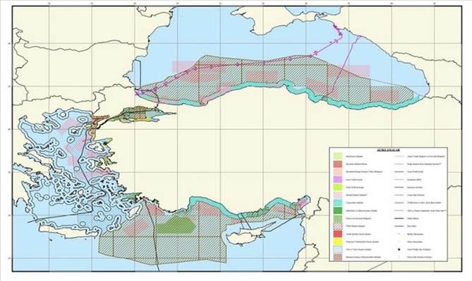
Greece’s Marine Spatial Plan (Protothema).
The core principles adopted by Greece in its MSP process are as follows:
Under this framework, the strategic objectives identified include increasing investments in marine energy, promoting sustainable fishing practices, planned expansion of tourism infrastructure, enhancing the effectiveness of marine protected areas, and ensuring the safety of maritime transport routes.
Greece’s official map covers three main marine regions: the Aegean Sea, the Ionian Sea and the Sea of Crete. Within these regions, areas allocated to different types of activities are distinguished by color codes and supported by technical data. The map has been made accessible through digital platforms and publicly shared.
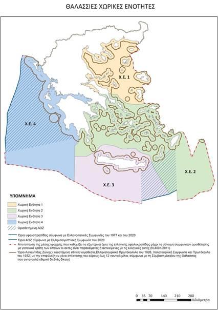
Zoned areas within the Marine Spatial Plan. (Protothema)
The main categories highlighted in the above map are as follows:
Greece’s MSP process has not been limited to environmental sustainability and economic development goals; it has also acquired a geopolitical dimension. Disputes with Türkiye over maritime jurisdiction in the Aegean Sea have directly linked MSP to foreign and security policy. In this context, Greece has presented its official Marine Spatial Plans not merely as reflections of environmental or economic objectives but as instruments mapping its sovereignty claims.
The official MSP map published in 2025 was strongly rejected by Türkiye and triggered international political debates. The map treats the maritime jurisdiction of islands as fully sovereign and includes planning zones in areas very close to Türkiye’s coastlines.
Türkiye considers this map contrary to its continental shelf rights and the principles of international maritime law. In diplomatic notes, Türkiye has stated that it does not recognize these arrangements due to its non-participation in the United Nations Convention on the Law of the Sea (UNCLOS).
When developing its MSP map, Greece assumed that all its islands are entitled to a continental shelf and exclusive economic zone. This understanding is consistent with the 1982 United Nations Convention on the Law of the Sea (UNCLOS), to which Greece is a party. However, Türkiye is not a party to the convention and does not recognize the relevant provisions.
Türkiye’s position holds that islands cannot generate maritime jurisdiction areas equivalent to those of mainland territory. In particular, the proximity of islands to each other and to Türkiye’s coasts in the Aegean Sea complicates the delimitation issue both technically and legally. This situation has led Türkiye to perceive Greece’s MSP map as an attempt to de facto define maritime jurisdiction areas.
Anadolu Agency. "Greece Discloses Its Official Maritime Spatial Planning Map." Anadolu Agency, April 16, 2025.https://www.aa.com.tr/en/europe/greece-discloses-its-official-maritime-spatial-planning-map/3540121.
Anadolu Agency. "Greece Discloses Its Official Maritime Spatial Planning Map." April 16, 2025.https://www.aa.com.tr/en/europe/greece-discloses-its-official-maritime-spatial-planning-map/3540121.
Greek Reporter. "Greece Unveils Its First Maritime Spatial Planning Framework." Greek Reporter, April 16, 2025.https://greekreporter.com/2025/04/16/greece-unveils-first-maritime-spatial-planning-framework/.
Greek Reporter. "Turkey Rejects Greece’s Maritime Spatial Planning." Greek Reporter, April 17, 2025.https://greekreporter.com/2025/04/17/turkey-rejects-greece-maritime-spatial-planning/.
Keep Talking Greece. "Maritime Spatial Planning: Greece and Turkey Present Competing Maps, Marine Parks Included." Keep Talking Greece, April 16, 2025.https://www.keeptalkinggreece.com/2025/04/16/msp-greece-turkey-mapsmarine-parks/.
New Greek TV. "Maritime Spatial Planning: How Athens 'Reads' Turkey’s Reaction." New Greek TV, April 17, 2025.https://www.newgreektv.com/news-in-english-for-greeks/greece/item/37486-maritime-spatial-planning-how-athens-reads-turkey-s-reaction.
Protothema. "After Greece, the Turks Also Presented a Map for Maritime Spatial Planning – They Are Splitting the Aegean in Two." Protothema English, April 16, 2025.https://en.protothema.gr/2025/04/16/after-greece-the-turks-also-presented-a-map-for-maritime-spatial-planning-they-are-splitting-the-aegean-in-two/.
Protothema. "From the 'Seville Map' to Marine Parks – What the Announcement of the Maritime Spatial Planning Means for Greece." Protothema English, April 16, 2025.https://en.protothema.gr/2025/04/16/from-the-seville-map-to-marine-parks-what-the-announcement-of-the-maritime-spatial-planning-means-for-greece/.
Protothema. "Greek-Turkish Map Clash Sparked by Marine Spatial Planning in the Aegean – Gerapetritis’ Message on The Hague." Protothema English, April 16, 2025.https://en.protothema.gr/2025/04/16/greek-turkish-map-clash-sparked-by-marine-spatial-planning-in-the-aegean-gerapetritis-message-on-the-hague/.
Protothema. "KYSEA: Two Scenarios of Turkey’s Reaction to the Maritime Spatial Plan on the 'Table' – Athens’ Assessments." Protothema English, April 16, 2025.https://en.protothema.gr/2025/04/16/kysea-two-scenarios-of-turkeys-reaction-to-the-maritime-spatial-plan-on-the-table-athens-assessments/.
Protothema. "Maritime Spatial Planning: How Athens 'Reads' Turkey’s Reaction – 'We Are Closing Pending Issues Without Communication Flares'." Protothema English, April 17, 2025.https://en.protothema.gr/2025/04/17/maritime-spatial-planning-how-athens-reads-turkeys-reaction-we-are-closing-pending-issues-without-communication-flares/.
Republic of Türkiye Ministry of Foreign Affairs. "No: 84, 16 April 2025, Regarding the 'Maritime Spatial Plan' Declared by Greece." April 16, 2025.https://www.mfa.gov.tr/no_-84_-yunanistan-in-ilan-ettigi-deniz-mekansal-planlamasi-hk.en.mfa
Stamford Advocate. "Greece Announces Plans on Maritime Use, Irking Neighboring Turkey." April 16, 2025.https://www.stamfordadvocate.com/news/world/article/greece-announces-plans-on-maritime-use-irking-20278958.php.
eKathimerini. "Greece Finalizes Marine Spatial Planning, Releases Official Map." eKathimerini, April 16, 2025.https://www.ekathimerini.com/politics/foreign-policy/1267174/greece-finalizes-marine-spatial-planning-releases-official-map/.

No Discussion Added Yet
Start discussion for "Greece's Marine Spatial Planning (MSP)" article
Greece’s Thematic Objectives
Characteristics and Scope of the Map
MSP as a Geopolitical Tool
MSP Tension Between Greece and Türkiye