`unesco-world-heritage` Related Article Results
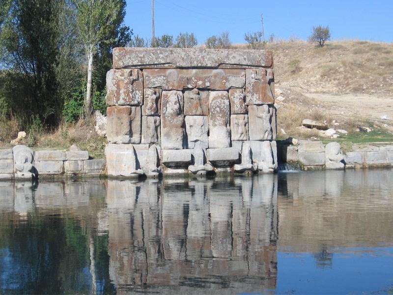
Eflatunpınar Hittite Water Monument
Eflatunpınar Hittite Water Monument is an archaeological structure dated to the final quarter of the 13th century BCE, located within the boundaries of Sadıkhacı Village in the Beyşehir district of Konya Province, Türkiye. It is believed to have been constructed during the reign of the Hittite Great King Tudhaliya IV. The monument is regarded as one of the most significant open-air sacred sites of the Hittite period due to its architectural design, reliefs, and water system.
EN
Ahsen Güneş
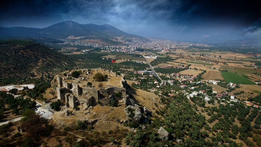
Beçin Castle and Archaeological Site
Beçin Castle and Archaeological Site is located within the boundaries of Beçin Village, approximately 5 kilometers south of the Milas district in Muğla Province. Beçin, accessible via the Milas-Ören road, is situated on a flat plateau about 200 meters above the Milas Plain, dominating the surrounding landscape. Archaeological remains from various periods are found at the foot of the steep northern slope of the castle and around its perimeter.Beçin Castle.(AA)" image-alternate="" image-element-fo
EN
Bilge Öztürk
 Ke
KeKeçi Bastion
Keçi Bastion is an important part of the fortification system within the boundaries of Diyarbakır. It rises on a naturally carved rock mass in the southeastern section of the city walls, east of the Mardin Gate. Its strategic location provides a commanding view of the city’s natural and historical landmarks, including the Tigris River, Hevsel Gardens, the Ten-Eyed Bridge, and Kırklar Mountain. Structurally, the tower is quite large and is considered the largest and oldest tower on the Diyarbakır
EN
Meltem Saraç
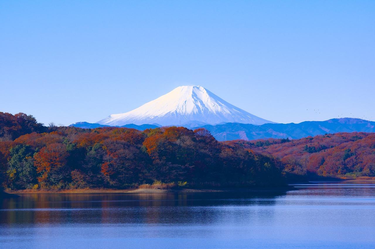
Mount Fuji
Mount Fuji (Japanese: 富士山, Fujisan) is the highest peak in Japan, standing at 3,776 meters. It is located in central Honshu Island, approximately 100 kilometers southwest of Tokyo. Known for its symmetrical conical shape, this stratovolcano is snow-capped for about half the year. Mount Fuji has long been recognized for its aesthetic and spiritual significance, both by the Japanese people and international observers.Geological FormationMount Fuji is a geologically young volcano that formed appro
EN
Ömer Faruk Bilcan
ÇaÇavuşin Church
Çavuşin Church is located at the entrance of Çavuşin Village, part of Avanos district in Nevşehir, situated on the Göreme-Avanos road approximately 2.5 kilometers from Göreme. The church is carved into natural rock and built in two levels: the lower floor consists of monk cells, while the upper floor serves as the worship area. The original natural staircase to the upper floor has collapsed and is now accessed by a later-added iron staircase. The church features a single nave with a barrel vault
EN
Melike Saraç

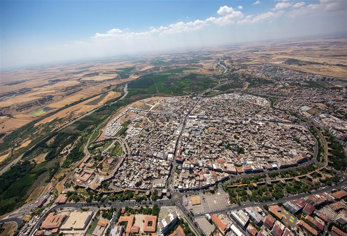
Diyarbakır Fortress and Havsel Gardens
Diyarbakır Castle and Hevsel Gardens is a two-component cultural landscape located within the boundaries of Diyarbakır Province in Türkiye. At the 39th UNESCO World Heritage Committee Meeting held in Bonn Germany in 2015, the Diyarbakır Castle and Hevsel Gardens Cultural Landscape was inscribed on the UNESCO World Heritage List as Türkiye’s 14th heritage site. Listed under number 1488, the site has been recognized under cultural criteria (i), (iii) and (v).Diyarbakır Castle and WallsDiyarbakır C
EN
Neriman Çalışkan
Afyonkarahisar Ulu Camii
Afyonkarahisar Ulu Camii was commissioned by Sâhipataoğlu Nusretiddin Hasan during the Anatolian Seljuk period between 1272 and 1277 for Emir Hâc Bey el-Neccar. Construction began in 671 AH and was completed in 676 AH. The structure is an original example of the group of Seljuk-era mosques with wooden columns and flat ceilings, and over time it has also been known as "Cami-i Kebir" and "Hocabey Camisi."The mosque is located in the center of Afyonkarahisar, within the boundaries of Tac Ahmet Maha
ENNeriman Çalışkan
Aizanoi Ancient City
Time TravelThe ancient city of Aizanoi, located in the Çavdarhisar district of Kütahya, has stood for more than 2,000 years and derives its name from the mythological hero Azan. According to legend, Azan was the son of the water nymph Erato and King Arkas. That is why Aizanoi is rich in both legends and authentic historical structures.Where?Aizanoi is situated approximately 50 kilometers from the city center of Kütahya, built along both banks of the Penkalas (Kocaçay) River. While exploring the
EN
Hikmet Can Urhan
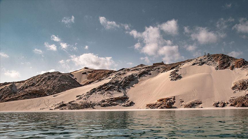
Socotra Island
Socotra Island is the largest of the Socotra Archipelago, located at the intersection of the northwestern Indian Ocean, the Gulf of Aden and the Arabian Sea, consisting of four main islands and two rocky islets. Strategically positioned south of mainland Yemen and east of the Horn of Africa, the island has hosted one of the planet’s most unique and undisturbed ecosystems due to its millions of years of isolation. Owing to its high proportion of endemic species, the area was inscribed on the UNES
EN
Emirhan Polat
Diyarbakır Walls
The Diyarbakır Walls are a historical defensive structure enclosing the city of Diyarbakır in southeastern Türkiye. The walls consist of two sections: the Inner Citadel and the Outer Citadel, and are believed to have originated from the Inner Citadel, which formed the earliest settlement core of the city on its northeastern side. Although no exact date is known for the construction of the walls, various sources generally date their origin to the mid-4th century. However, it is believed that the
EN
Mehmet Tahir Özbey